Gulf of Fonseca: Central America’s Coastal Treasure
The Gulf of Fonseca is an inlet of the Pacific Ocean nestled along the coasts of El Salvador, Honduras, and Nicaragua. This picturesque body of water, renowned for its ecological diversity, historical significance, and economic importance, is a critical maritime hub in the region.


 towers above sandy beaches along the Gulf of Fonseca at the SE tip of El Salvador - via Wikimedia Commons")
Exploring the Gulf of Fonseca: Nature, Culture, and History
The Gulf of Fonseca is a stunning inlet of the Pacific Ocean nestled along the coasts of three Central American countries: El Salvador, Honduras, and Nicaragua. This picturesque body of water, renowned for its ecological diversity, historical significance, and economic importance, is a critical maritime hub in the region. Encompassing a mix of pristine beaches, lush mangroves, and vibrant marine life, the Gulf of Fonseca is a testament to Central America's natural beauty and cultural richness.
Geography and Physical Features
Location and Boundaries
The Gulf of Fonseca covers an area of approximately 3,200 square kilometers (1,235 square miles) and stretches about 74 kilometers (46 miles) from north to south and 50 kilometers (31 miles) from east to west. El Salvador borders it to the northwest, Honduras to the northeast, and Nicaragua to the southeast. The Gulf is characterized by its broad, shallow waters, interspersed with numerous islands and islets, creating a complex and dynamic coastal ecosystem.
Islands and Islets
One of the most striking features of the Gulf of Fonseca is its array of islands, each with unique charm and significance. Notable islands include:
- Isla del Tigre (Honduras): Known for its conical volcanic peak, Isla del Tigre offers stunning panoramic views and a glimpse into the region's volcanic past.
- Isla Zacate Grande (Honduras): This island is larger and more populated, featuring a mix of rural communities and natural landscapes.
- Isla Meanguera (El Salvador): This popular tourist destination boasts beautiful beaches and tranquil waters.
- Isla Meanguerita (El Salvador): Often visited in conjunction with Isla Meanguera, this smaller island is known for its pristine natural beauty.
- Isla de Amapala (El Salvador): This island is another volcanic formation with rich historical and cultural significance.
Coastal Features
The Gulf's coastline blends sandy beaches, rocky shores, and extensive mangrove forests. These mangroves play a crucial role in maintaining the region's ecological balance by providing habitat for various species of fish, birds, and other wildlife. The estuaries and tidal flats along the coast are essential for the reproductive cycles of many marine organisms, making the Gulf of Fonseca a vital nursery for marine biodiversity.
Ecological Significance
Biodiversity
The Gulf of Fonseca is a biodiversity hotspot, home to a wide range of flora and fauna. Its waters teem with diverse marine life, including fish, crustaceans, and mollusks. The mangrove forests and estuaries support various bird species, such as pelicans, herons, and egrets, as well as reptiles like crocodiles and iguanas. The interconnected ecosystems within the Gulf create a rich tapestry of life that is both intricate and resilient.
Conservation Efforts
Given its ecological importance, several conservation initiatives have been established to protect the Gulf of Fonseca's natural resources. These efforts include the creation of protected areas and reserves, sustainable fishing practices, and community-based conservation programs. Regional cooperation among El Salvador, Honduras, and Nicaragua is crucial for successfully implementing these initiatives, as the health of the Gulf's ecosystem transcends national boundaries.
Historical and Cultural Significance
Pre-Columbian History
The Gulf of Fonseca has a long history of human settlement dating back to pre-Columbian times. Indigenous peoples, such as the Lenca and Chorotega, inhabited the region, relying on its rich natural resources for sustenance and trade. Archaeological sites and artifacts found in the area provide valuable insights into the ancient cultures that once thrived along the Gulf's shores.
Colonial Era
During the colonial era, the Gulf of Fonseca played a significant role in the Spanish conquest and colonization of Central America. The Gulf's strategic location made it an important maritime route for the transportation of goods and people. The Spanish established settlements and forts along the coast, many of which still bear the architectural remnants of this period. These historical landmarks testify to the region's colonial past and enduring influence on the local culture.
Modern-Day Cultural Landscape
Today, the cultural landscape of the Gulf of Fonseca is a vibrant mosaic of traditions, languages, and customs. The coastal communities in El Salvador, Honduras, and Nicaragua celebrate their rich cultural heritage through festivals, music, dance, and cuisine. The fusion of indigenous, African, and European influences is evident in the region's cultural expressions, making the Gulf of Fonseca a unique and dynamic cultural corridor.
Economic Importance
Fishing and Aquaculture
The Gulf of Fonseca is a vital economic resource for the surrounding communities, with fishing and aquaculture being the primary livelihoods for many residents. The Gulf's waters are abundant with various fish species, including snapper, grouper, and shrimp, essential for local consumption and export. Sustainable fishing practices and aquaculture initiatives are being promoted to ensure the long-term viability of these industries while protecting the marine environment.
Tourism
Tourism is another significant economic driver in the Gulf of Fonseca region. The area's natural beauty, rich biodiversity, and cultural heritage attract visitors from around the world. Popular tourist activities include island hopping, bird watching, hiking, and exploring historical sites. Developing eco-tourism initiatives aims to provide economic opportunities for local communities while promoting environmental conservation.
Maritime Trade
The Gulf of Fonseca's strategic location along the Pacific coast makes it an important hub for maritime trade in Central America. The ports of La Unión in El Salvador, San Lorenzo in Honduras, and Corinto in Nicaragua facilitate the movement of goods and commodities, contributing to the regional economy. Investments in port infrastructure and regional cooperation are essential for enhancing the Gulf's role in international trade.
Challenges and Future Prospects
Environmental Threats
Despite its ecological and economic importance, the Gulf of Fonseca faces several environmental threats. These include pollution from agricultural runoff and industrial activities, deforestation of mangrove forests, and overfishing. Climate change poses additional risks, such as rising sea levels and increased frequency of extreme weather events. Addressing these challenges requires local, national, and regional coordinated efforts.
Regional Cooperation
The future of the Gulf of Fonseca depends on effective regional cooperation among El Salvador, Honduras, and Nicaragua. Collaborative initiatives for environmental protection, sustainable development, and conflict resolution are essential for ensuring the Gulf's long-term health and prosperity. Strengthening regional institutions and fostering cross-border partnerships will be crucial for achieving these goals.
Conclusion
The Gulf of Fonseca is a remarkable example of Central America's natural beauty and cultural richness. Its diverse ecosystems, historical significance, and economic potential make it a vital asset for the region. As efforts to protect and sustainably develop the Gulf continue, the harmonious coexistence of human activity and natural preservation will ensure that future generations can enjoy and benefit from this coastal gem. The Gulf of Fonseca, with its unique blend of nature, history, and culture, remains a testament to Central America's enduring spirit and resilience of Central America.
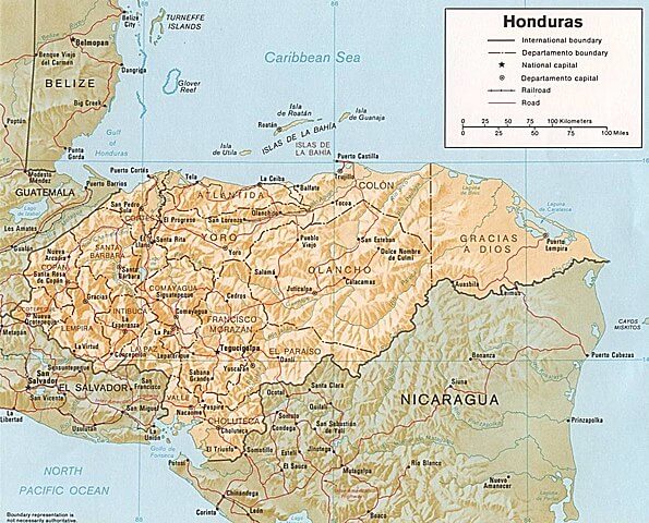
Map showing the position of the Gulf of Fonseca (bottom left) to Honduras, El Salvador, and Nicaragua.