Uruguay: Natural Landscape
Uruguay, located on the southeastern Atlantic coast of South America's Southern Cone, is known for its unique natural beauty and ecological diversity. It boasts a surprisingly wide range of ecosystems, primarily characterized by its expansive grasslands, known as the Pampas.
 https://www.flickr.com/photos/ciat/6809968788")
 https://www.flickr.com/photos/bombeador/33763909743")

, via Wikimedia Commons")
 https://www.flickr.com/photos/bombeador/29227376452")


 https://www.flickr.com/photos/davidalmeida/8076188640")
 https://www.flickr.com/photos/marcelocampi/26080691025")
 https://www.flickr.com/photos/bombeador/31546253233")
 https://www.flickr.com/photos/gravitywave/6967475")
The Natural Landscape of Uruguay: A Tapestry of Coastal Beauty, Grasslands, and Biodiversity
Uruguay, nestled on the southeastern Atlantic coast of South America's Southern Cone, is a country of unique natural beauty and ecological diversity. Situated between Brazil to the north and east and Argentina to the west, Uruguay occupies 176,215 square kilometers (68,037 square miles), ranking as the second-smallest country in South America after Suriname. Additionally, Uruguay encompasses around 2,600 square kilometers (1,004 square miles) of inland water, further enhancing its geographical diversity and contributing to the country's varied ecosystems and natural resources.
Coastline and Rivers: Lifelines of Uruguay's Geography
Uruguay's coastline stretches 660 kilometers (410 miles) along the Atlantic Ocean, fostering rich coastal ecosystems and playing a vital role in shaping the nation's climate, economy, and cultural identity. The oceanic influence is evident in Uruguay's maritime economy, fishing industry, tourism, and unique coastal habitats, ranging from sandy beaches to rocky outcrops.
The Uruguay River, forming the western border with Argentina, is historically significant and serves as a major waterway for trade, recreation, and agriculture. On the northern and eastern borders, the Jaguarão or Yaguarón River delineates Uruguay's frontier with Brazil, creating a natural boundary that not only aids in irrigation and supports local wildlife but also underscores the country's geopolitical positioning within the Southern Cone.
Biodiversity: The Wealth of Uruguay's Flora and Fauna
While modest in size, Uruguay supports a surprisingly diverse range of ecosystems, dominated by expansive grasslands known as the Pampas. These plains are critical habitats for numerous bird species, small mammals, and reptiles. Uruguay ranks 83rd on the Global Biodiversity Index, indicating a rich variety of plant and animal life. The country is home to approximately 409 bird species, 50 amphibian species, 725 fish species, 107 mammal species, 79 reptile species, and nearly 3,000 species of vascular plants.
Although Uruguay's biodiversity is not as extensive as that of neighboring Brazil or Argentina, its grasslands and wetlands sustain vital species and ecosystems that enrich the country's natural landscape. These ecosystems support a broad spectrum of wildlife and play an essential role in maintaining soil health and water quality, directly impacting agriculture, one of Uruguay's main economic sectors.
Conservation Efforts: Safeguarding Uruguay's Natural Heritage
Uruguay has made notable strides in conservation, establishing a comprehensive network of national parks, reserves, and protected landscapes across the country. This network includes notable sites such as the Bioma Pampa-Quebradas del Norte Biosphere Reserve, known for its unique grassland ecosystems, and Cabo Polonio National Park, famous for its unspoiled beaches, dunes, and wildlife.
Among Uruguay's international conservation efforts is the Ramsar-recognized Bañados del Este y Franja Costera Biosphere Reserve, a critical wetland area that supports countless species and acts as a natural filter for surrounding waterways. This designation reflects Uruguay's commitment to protecting these sensitive ecosystems while balancing sustainable development goals. Despite its proactive conservation approach, Uruguay faces challenges, such as habitat loss due to urban expansion and invasive species that threaten native plants and animals. Efforts to balance environmental preservation with development underscore Uruguay's dedication to sustaining its biodiversity for future generations.
Climate: A Humid Subtropical Landscape with Seasonal Variation
Uruguay's climate, classified as humid subtropical (Cfa) according to the Köppen climate system, remains relatively consistent across the country. The temperate zone location contributes to mild seasonal changes, supported by Uruguay's water-rich landscape, which moderates temperature extremes and sustains high humidity levels. Seasonal transitions are distinct: spring brings cool, windy, wet conditions, followed by warm, comfortable summers. Autumns are mild, while winters, though not severe, are cool and damp.
Without significant geographic barriers such as mountains, Uruguay experiences high winds and rapid weather shifts, especially when atmospheric fronts or storms move across the region. This absence of topographical obstructions allows weather patterns to sweep across the country, resulting in quick and sometimes drastic changes in temperature and precipitation. As a result, Uruguay's climate is generally mild but also dynamic, with seasonal variability that shapes daily life and agricultural practices.
Uruguay's Grasslands: The Heart of the Pampas
The grasslands, or Pampas, are Uruguay's most extensive biome, representing both an ecological treasure and a backbone of the national economy. This vast stretch of fertile plains supports a variety of native species and is ideal for agriculture and livestock grazing. The Pampas contribute to Uruguay's prominence as a leading producer of beef and wool, which remain staples of the economy. Besides their agricultural value, the grasslands offer a rich habitat for species such as the pampas fox, armadillo, and capybara, along with migratory birds like the white stork and rufous-collared sparrow. Grassland conservation is vital for sustaining Uruguay's biodiversity, as these ecosystems play a crucial role in water retention, carbon storage, and maintaining soil health.
Rivers, Wetlands, and Lagoons: Vital Water Ecosystems
Beyond the coastline, Uruguay is home to a network of rivers, wetlands, and lagoons that sustain diverse aquatic species and are crucial for the water supply. The Río Negro, Uruguay's longest river, traverses the country and provides essential water resources for irrigation and hydroelectric power. In the east, the Laguna Merín (Merín Lagoon), one of the largest freshwater lagoons in South America, serves as a sanctuary for birdlife and a significant site for fish breeding, supporting both wildlife and local communities. Wetland areas, especially coastal regions, buffer against erosion and flooding, showcasing Uruguay's interconnectedness between terrestrial and aquatic ecosystems.
Forests and Woodlands: Small but Significant Green Spaces
Uruguay's natural forests are modest in size but ecologically significant. Found primarily along riverbanks and in some coastal regions, native tree species include the ombú, laurel, and espinillo, which contribute to the biodiversity of local flora and fauna. The introduction of eucalyptus and pine for commercial forestry has been a significant development in recent decades. While these plantations have economic value, they pose challenges to native ecosystems by altering water tables and competing with native species. Sustainable forestry practices are gaining attention as Uruguay works to balance economic growth with environmental stewardship.
The Challenge of Environmental Preservation
While rich and diverse, Uruguay's natural landscape faces environmental challenges, particularly urban expansion, pollution, and climate change. Deforestation, habitat fragmentation, and introducing invasive species, such as the wild boar, disrupt native ecosystems. Moreover, industrial agriculture and livestock farming exert pressure on water resources and soil quality. However, Uruguay's commitment to sustainable practices, illustrated through initiatives like organic agriculture and renewable energy projects, underscores a national effort to mitigate environmental degradation and preserve the natural landscape for future generations.
Conclusion: A Nation of Natural Beauty and Commitment to Conservation
Uruguay's natural landscape is a unique mosaic of grasslands, rivers, wetlands, and coastal ecosystems. Uruguay's geography and biodiversity are central to shaping its cultural identity and economy, from the fertile Pampas to the vibrant coastlines and protected natural reserves. Uruguay demonstrates its dedication to preserving this rich natural heritage through extensive conservation efforts and sustainable practices. As a small yet ecologically significant nation, Uruguay is a beacon of balance between environmental stewardship and economic development, showcasing its commitment to protecting the natural beauty and diversity that define its landscape.
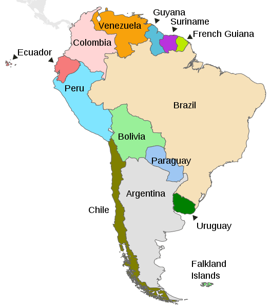
Map depicting the countries on the continent of South America
Natural Geography of Uruguay
Topography
Uruguay's relief features are not well defined. Much of the countryside consists of a gently rolling plain that represents a transition from the almost featureless Argentine pampas in the west to the hilly uplands of southern Brazil in the east.
Flat plains flank the country on its southern, eastern, and western perimeters. The Atlantic coastal plain is sandy and marshy, often hosting lagoons and shallow tidal lakes. The shore areas (littorals) of the Río de la Plata and the Uruguay River are somewhat broader and merge gradually into the hilly interior. The remaining three-quarters of the country is a rolling plateau marked by ranges of low hills that become more prominent in the north as they merge into the highlands of southern Brazil. However, elevations in these hilly areas seldom exceed 200 m (650 ft) asl.
Uruguay has no mountain ranges. The Grande Range is a hill range that extends southward from the Brazilian border, almost to the Atlantic seaboard in the south. Here, it is bisected by the Sierra Carape hill range. Cerro Catedral, the highest point in the country at an elevation of 514 m (1,686 ft), is located here. The Cuchilla de Haedo (Haedo Range) is a low range of hills in the north-northwest of the country. The Bioma Pampa-Quebradas del Norte Biosphere Reserve is located on its east side. It comprises a mosaic of different ecosystems, including a primary forest with a subtropical jungle.
Streams and rivers sculpt the countryside, consisting of four river basins, or deltas: the Río de la Plata Basin, the Uruguay River, and the major internal river, the Río Negro. Several lagoons are found along the country's Atlantic coast. These lagoons, which are half-freshwater and half-saltwater, are often separated from the ocean by just a thin strip of sand and are home to much of the country's wildlife. In addition, the Bañados del Este y Franja Costera wetland and Biosphere Reserve are located in the east.
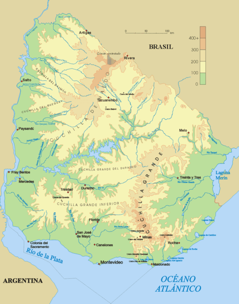
Topographical map of Uruguay.
Geographic Regions
The country may be divided into four general regions based on social, economic, and geographical factors:
- Atlantic Coast / Bañados del Este
- Río de la Plata
- Central Interior
- Northern Interior
Atlantic Coast / Bañados del Este
The Atlantic Coast region stretches east of Montevideo and south of the country. It includes a string of small seaside towns, including the major resort of Punta del Este. The inland portion includes many small farms and truck gardens that grow vegetables and produce for the larger cities and resorts.
Located in southeast Uruguay, the Bañados del Este Biosphere Reserve harbors a remarkable complex of ecosystems, including white sand beaches, dunes, and lagoons along the Atlantic coast. This variety of habitats is home to a rich diversity of wildlife and remains almost intact on land and at sea.
Río de la Plata
The Greater Montevideo region has over half of Uruguay's population and is known for its well-preserved historical sites and colonial towns like Colonia del Sacramento. The agricultural and dairying area stretches west along the Río de la Plata from Montevideo. The littoral or coastal zone is to the north along the Uruguay River, a somewhat more developed region than the interior. Here, soils are alluvial and more fertile, favoring crop production and modest-sized farms.
Central Interior
The Central Interior region features rolling hills and pastures, which account for most of the productive land. Sheep rearing on medium-sized farms is concentrated in the west and south.
Northern Interior
The Northern Interior region is a land of ranches, cattle, and horses. Large cattle ranches (estancias) are concentrated in the north and east, and citrus growing is found in the west.
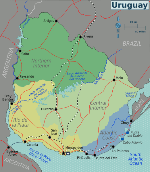
Map depicting the general regions of Uruguay.
Islands and Archipelagos.
Uruguay is a country with a relatively short coastline and no significant archipelagos. However, it does have a few islands and islets along its coast. Here are some of the notable islands in Uruguay:
Isla de Flores: Located in the Uruguay River, near Paysandú, this island is known for its historical significance and natural beauty.
Isla de Lobos: Situated in the Atlantic Ocean, this small island is known for its large colony of South American sea lions. It's a protected area and can be visited via authorized boat tours.
Isla de las Gaviotas: Found near Punta del Este, this island is known for its birdlife and is often visited for birdwatching.
Isla Gorriti: Located off the coast of Punta del Este, Isla Gorriti is a popular tourist destination. It features sandy beaches and recreational facilities.
Isla Timoteo Domínguez: Situated in the Uruguay River near Fray Bentos, this island is known for its history and is accessible by boat.
Isla Rasa: This small island is located near Carmelo and is known for its natural beauty.
Islote de Colastiné: A small islet in the Uruguay River near Paysandú.
Islas de Torres: A group of small islands in the Río Negro, near the city of Mercedes.
Bodies of Water
Due to its compact size and geographical features, Uruguay has limited bodies of water. While Uruguay's bodies of water may not be as extensive as some of its neighboring countries, they still play essential roles in its geography, economy, and cultural identity. The Río de la Plata and the Atlantic coastline provide critical connections to the sea, facilitating trade and tourism. At the same time, the Uruguay River and the freshwater lagoons contribute to regional biodiversity and water resources.
See more: Water Bodies of Uruguay
Natural Regions
Ecological Regions
The country's entire land area is part of the Uruguayan savanna, also known as the Brazilian-Uruguayan savanna, a subtropical grassland and savanna ecoregion. The Uruguayan savanna is critically endangered, and only a few small isolated patches of intact habitat remain. Cattle ranching, one of the main pillars of Uruguay's national economy, has severely altered the whole ecoregion.
Administrative Divisions
Uruguay is divided into 19 administrative departments, each with its capital city. Each department has a legislature and chief executive.
See more: Cultural Landscape of Uruguay
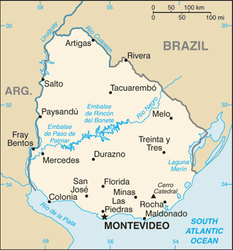
CIA map of Uruguay.