The Uruguay River: A Vital Waterway of South America
The Uruguay River is a significant fluvial system in South America. It stretches from its headwaters in Brazil's coastal range to its confluence with the Río de la Plata. As a natural boundary between Brazil, Uruguay, and Argentina, the river plays a crucial role in the region's geography, economy, and ecology.


 https://www.flickr.com/photos/flissphil/5313240551")

 https://www.flickr.com/photos/90963248@N00/3044153297")

Flowing Borders: The Course and Impact of the Uruguay River
The Uruguay River is a significant fluvial system in South America. It stretches approximately 1,600 kilometers (1,000 miles) from its headwaters in Brazil's coastal range to its confluence with the Río de la Plata. As a natural boundary between Brazil, Uruguay, and Argentina, the river plays a crucial role in the region's geography, economy, and ecology. An exploration of the Uruguay River reveals its origins, course through diverse landscapes, ecological significance, and role in regional development.
Geographic Origin and Course
The Uruguay River begins in southern Brazil, with its primary headstream, the Pelotas River, originating in the Serra Geral at an elevation of 1,800 meters (5,900 feet) above sea level. The Pelotas River flows northeast for about 450 kilometers (280 miles) before meeting the Canoas River, at which point it takes the name Uruguay. The river initially flows westward through Brazil, marking part of the boundary between Brazil and Argentina, before turning southwestward and eventually southward near the Brazil/Argentina/Uruguay border tripoint.
Tributaries and Confluence
The river's most significant tributary is the Río Negro, which originates in southern Brazil and flows through Uruguay for approximately 500 kilometers (300 miles) before joining the Uruguay River about 100 kilometers (62 miles) north of its confluence with the Río de la Plata. The Uruguay and Paraná Rivers converge to form the vast Río de la Plata estuary, one of the most critical water bodies in South America, influencing the region's climate, economy, and ecology.
Drainage Basin and Hydrology
The Uruguay River's drainage basin covers an area of 365,000 square kilometers (141,000 square miles), encompassing parts of Brazil, Uruguay, and Argentina. The river's hydrology is influenced by seasonal rainfall patterns, with significant fluctuations in water levels throughout the year. The river's primary economic use is hydroelectric power generation, with major dams such as the Salto Grande Dam on the lower Uruguay and the Itá Dam further upstream in Brazil harnessing the river's flow.
Ecological Significance
The Uruguay River basin supports diverse ecosystems, ranging from subtropical forests to wetlands. These habitats are home to numerous species of fish, birds, and other wildlife, many of which are endemic to the region. Compared to the sediment-laden Paraná River, the river's clear waters contribute to distinct ecological conditions, supporting different species and environmental processes. The Uruguay River also plays a crucial role in the regional hydrological cycle, influencing groundwater recharge, soil moisture, and local climate patterns.
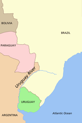
Uruguay River location map.
Moconá/Yucumã Falls
One of the Uruguay River's most unusual features is the Moconá Falls, the Yucumã Falls in Brazil. Located on the border between Argentina and Brazil, this submarine canyon is visible only when water levels are low, revealing a series of cascading waterfalls. The falls are unique due to their longitudinal orientation, parallel to the river's flow, and can reach up to 12 meters (40 feet) in height. However, they are often submerged and appear as rapids when water levels rise, making them visible for only about 150 days each year.
Economic and Human Impact
The Uruguay River is integral to the region's economy, primarily through hydroelectric power generation. The Salto Grande Dam, located near Concordia in Argentina and Salto in Uruguay, is one of South America's most significant hydroelectric projects. In addition to power generation, the river supports agriculture, fishing, and transportation, providing livelihoods for communities along its banks.
Several international bridges cross the river, facilitating trade and transportation between Argentina, Uruguay, and Brazil. These include the Integration Bridge, Paso de los Libres-Uruguaiana International Bridge, Salto Grande Bridge, General Artigas Bridge, and Libertador General San Martín Bridge. These crossings are vital for regional connectivity and economic integration.
Conclusion
The Uruguay River is a dynamic and vital waterway in South America, shaping the geography, ecology, and economy of the region it traverses. From its origins in Brazil's highlands to its confluence with the Río de la Plata, the river is crucial in defining the borders between nations, supporting diverse ecosystems, and driving economic development. Its unique features, such as the Moconá/Yucumã Falls, add to its significance as a natural wonder and a symbol of the interconnectedness of the region's natural and human landscapes.
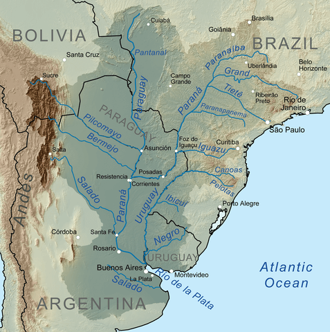
Map depicting the Uruguay River within the Río de la Plata Basin.