Peru: Natural Landscape
Peru, a South American country on the western coast, is famous for its diverse landscapes, including the Andes Mountains and the Amazon rainforest. Its natural beauty complements a rich cultural heritage, with arid coastal deserts and lush rainforests supporting exceptional biodiversity.
, https://www.flickr.com/photos/cifor/35742787281")
 https://www.flickr.com/photos/neilspicys/2348881979")


")


, https://www.flickr.com/photos/rod_waddington/8642623276")
The Natural Landscape of Peru
Peru, a South American country with breathtakingly diverse landscapes, occupies a central position along the continent's western coast. Renowned for its stunning geography, which ranges from the rugged Andes Mountains to the vast Amazon rainforest, Peru's natural beauty is as varied as its rich cultural heritage. From the arid coastal deserts along the Pacific Ocean to towering peaks and verdant rainforests, the country's landscapes support exceptional biodiversity and cultural history. Bordered by Ecuador and Colombia to the north, Brazil to the east, Bolivia to the southeast, and Chile to the south, Peru serves as a bridge for various ecological and cultural regions.
Geographical Regions and Ecosystems
The Coast: A Landscape of Desert and Desert-Oasis Valleys
Stretching 2,400 kilometers (1,500 miles) along the Pacific, Peru's coastline is a narrow but diverse strip featuring arid deserts, coastal valleys, and a few fertile regions nourished by rivers originating in the Andes. This desert coast is home to unique ecosystems and protected areas, such as the Paracas National Reserve, where marine life thrives, and desert landscapes meet the Pacific in stunning contrasts. Due to the cool Humboldt Current, Peru's coast has a subtropical desert climate with mild temperatures and sparse rainfall, contributing to its unique flora and fauna.
The Andes: Towering Peaks and Sacred Valleys
The Andes Mountains cut through the heart of Peru, creating a dynamic landscape marked by dramatic mountain ranges, fertile valleys, and high-altitude plains. This region includes some of the highest peaks in the world, such as Huascarán, which reaches an elevation of 6,768 meters (22,205 feet). The Andes support diverse climates, from temperate valleys to frigid alpine tundra at higher altitudes, and are a treasure trove of biodiversity, harboring unique species adapted to high-elevation conditions. Terraced agriculture and irrigation systems developed by the Inca are still visible here, particularly in the Sacred Valley, where traditional farming practices endure.
The Andes are the cradle of Incan civilization and remain a region steeped in cultural and spiritual significance. Ancient cities like Machu Picchu and Cusco are UNESCO World Heritage Sites, drawing millions of visitors each year. The Andes also host unique ecosystems like páramo grasslands and cloud forests, which are critical habitats for a variety of plant and animal species, some of which are found nowhere else in the world.
The Amazon Rainforest: A Biodiversity Hotspot
The eastern part of Peru descends into the Amazon basin, one of the world's richest and most complex ecosystems. This lush rainforest region, covering over 60% of the country, is home to diverse wildlife, including jaguars, giant otters, pink river dolphins, and an astonishing array of bird and plant species. Peru's Amazon Basin is among the world's most biodiverse regions, hosting over 2,000 species of birds, 500 mammals, and numerous amphibians, reptiles, and insects. Manú National Park and Tambopata National Reserve are among the protected areas that support both the local biodiversity and indigenous communities.
Biodiversity: A Global Ecological Treasure
Peru ranks among the world's top megadiverse countries, with ecosystems that vary from deserts and mountains to rainforests and marine environments. The country boasts 84 of the 103 known ecosystems and 28 of the world's 32 climates, according to the Global Biodiversity Index, which ranks Peru as the seventh most biodiverse country globally. Peru's species count is impressive: 1,861 bird species, 655 amphibians, 1,583 fish, 490 mammals, 510 reptiles, and nearly 20,000 vascular plants. This biodiversity is attributed to Peru's varied geography, climate zones, and ecosystems, creating distinct habitats that support a wide range of life forms.
Despite its rich biodiversity, Peru faces several environmental challenges, including deforestation, illegal mining, and habitat loss. Conservation efforts are crucial to preserving the delicate ecosystems that make Peru a biological hotspot and ensuring that this natural wealth remains for future generations.
Conservation Efforts
Peru has taken significant steps toward conserving its ecosystems and biodiversity, establishing a network of national parks, reserves, and protected areas to safeguard vulnerable species and habitats. Manú National Park, for instance, covers nearly 1.5 million hectares (3.7 million acres) and protects an astonishing range of habitats, from lowland rainforests to high-elevation cloud forests. In the southern Amazon region, Tambopata National Reserve serves as a sanctuary for numerous wildlife species and promotes sustainable tourism and research.
However, conservation challenges persist, including illegal deforestation, poaching, and the encroachment of agricultural lands into protected areas. Peru's National System of State-Protected Natural Areas (SINANPE) coordinates conservation initiatives, but balancing preservation with economic development remains a delicate task. The Peruvian government collaborates with indigenous communities and international organizations to address these issues, ensure conservation strategies, and respect cultural heritage and local livelihoods.
Climate Zones: A Land of Contrasting Weather Patterns
Peru's location along the equator and diverse topography create a range of climate zones with three primary regions: the coast, the Andes, and the Amazon Basin.
Coastal Climate
Peru's coastal region, influenced by the Humboldt Current, has a subtropical desert climate with mild temperatures year-round, ranging from 18 to 26°C (64 to 79°F). Rainfall is minimal, with most areas receiving less than 250 mm (10 in) annually. From December to April, the rainy season brings light and sporadic rainfall. Coastal cities like Lima experience misty winters and dry summers, providing a unique climate for the region.
Andean Climate
The climate of the Andes varies significantly with altitude. In the lower valleys, temperatures range between 10 and 20°C (50 to 68°F), while high-altitude regions experience colder conditions, with temperatures averaging from 5 to 10°C (41 to 50°F). Rainfall is more frequent in the Andes, with annual precipitation ranging from 500 to 1,000 mm (20 to 40 in) in most areas and reaching over 1,000 mm (40 in) at higher altitudes. The rainy season lasts from October to April, nourishing the terraced landscapes and sustaining highland communities.
Amazon Climate
The Amazon basin has a tropical rainforest climate, characterized by high temperatures and humidity throughout the year, with averages ranging from 25 to 30°C (77 to 86°F). Rainfall is abundant, with most areas receiving over 2,000 mm (80 in) of precipitation annually, supporting dense vegetation and rich biodiversity. The rainy season from October to April is critical for the Amazon's ecosystems, replenishing rivers and flooding wetlands that sustain diverse species.
Volcanism: Peru's Fiery Peaks
Peru is located within the Pacific Ring of Fire, a zone of high tectonic activity responsible for the country's volcanic landscape. Peru's active and dormant volcanoes are primarily situated in the southern Andes, shaping the natural landscape and local communities.
Active volcanoes in Peru include:
- Ubinas: Located in southern Peru, Ubinas is one of the country's most active volcanoes, with frequent eruptions over recent decades.
- Sabancaya: This stratovolcano has increased activity, producing ash plumes and frequent eruptions.
- Misti: Near the city of Arequipa, Misti is an active stratovolcano closely monitored for its potential impact on local communities.
- Tutupaca: Situated in the Tacna region, Tutupaca has a history of eruptions affecting its surroundings.
Dormant volcanoes, like Huaynaputina and Coropuna, are also prominent features of Peru's landscape and hold potential for geothermal energy development, an area under exploration as a sustainable energy source.
Conclusion: Peru's Diverse Natural Heritage
Peru's natural landscape is a mosaic of ecosystems and climates that support unparalleled biodiversity. From the deserts of the coast to the soaring Andes and the lush Amazon rainforest, the country's varied geography forms the backbone of its environmental and cultural identity. Efforts to preserve these diverse ecosystems are essential as Peru navigates development challenges, climate change, and environmental protection. By recognizing the importance of its natural treasures, Peru safeguards its ecological legacy but sustains its cultural heritage, making it a land of breathtaking beauty and immense ecological significance.
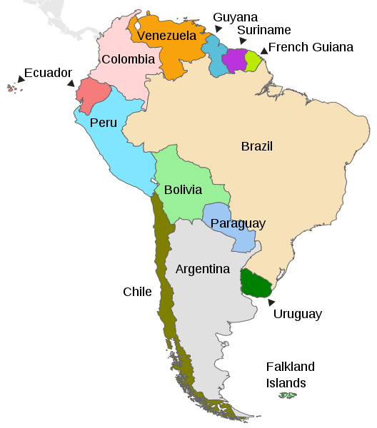
Map depicting the countries on the continent of South America.
Natural Geography of Peru
Geographic Regions
Peru is traditionally described as three broad longitudinal regions. Each region comprises a different topography and sharply contrasting environment, thus forming the country's major terrestrial regions.
La Costa: The arid Costa, or coastal region, in the west
La Sierra: The rugged Sierra, or the Peruvian Andes, in the middle
La Selva: The wet and forested Amazonia, or jungle region, in the east
Three broad climatic regions can be readily distinguished, paralleling the three main geographic regions: coastal desert, mountain highland, and tropical forest.
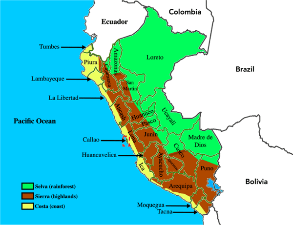
Map of Peru, showing its three geographical regions and 25 departments.
Coastal Plain (La Costa)
The coastal region of Peru is a bleak, often rocky desert that runs the entire length of the country, from Ecuador in the north to Chile in the south. The landscape is punctuated by many rivers and streams that descend through steep, arid mountains in the east and empty into the Pacific Ocean in the west.
The coastal plain can be divided into three parts: north, central, and south. Generally speaking, the level of coastal land diminishes from north to south.
North: In the northern region, the plain is typically about 30 - 50 km (20 - 30 mi) wide, with a maximum width of more than 140 km (90 mi) in the Sechura Desert.
Central: The central coastal region is narrower than the northern region and is characterized by rough hills extending from the Andes to the ocean's shores.
South: From Nazca southward to the Chilean border, the coast is lined mainly by low mountains with narrow valleys near the ocean.
Evidence of plant life is relatively rare in the barren desert of coastal Peru. However, Lomas (a mix of grasses and other herbaceous species) are common where coastal fog is heavy. In the north coast region, some parts of the desert are covered by epiphytes or by stands of sapote or algarroba (mesquite).
The most important feature of the coast is the enormous number of birds, marine mammals, and fish in the coastal waters. These include anchovies, Corvina (sea bass), tuna, swordfish, and marlin. In addition, sea lions thrive in isolated parts of the coast. Birdlife is heavy on islands off the coast. The most important bird species are pelicans, cormorants, gannets, and gulls. In addition, Humboldt penguins, an endangered species, are found as far north as the Ballestas Islands near the Paracas Peninsula.
Coastal Desert Climate: From the Peruvian-Ecuadoran border south to northern Chile, the west coast of Peru has one of the Earth's driest climates. The Andes Mountains block rain-bearing winds from the Amazon Basin. Because of this, air masses moving toward the coast produce little rainfall, and northward-flowing cold water off the coast (the Humboldt Current) contributes little moisture to surface air masses. Temperatures in this coastal desert are not hot, however. Average temperatures in Costa range from 19 °C (66 °F ) in winter to 22 °C (72 °F ) in summer. Despite its dryness, some parts of the coastal region receive sufficient moisture from winter fogs (locally known as garúa) to support some vegetation.
Andean Highlands (La Sierra or Los Montañas)
The Sierra Highlands natural region, containing the Peruvian Andes, is Peru's commanding feature—hundreds of permanently glaciated and snowcapped peaks tower over the valleys. The region includes the Altiplano plateau and the country's highest peak, the 6,768-meter (22,205-foot) Huascarán.
Several mountain groups are found within the region of the Andean highlands, including the Cordillera Negra, Cordillera Blanca, Cordillera del Cóndor, Cordillera Huayhuash, Cordillera Vilcanota, and Cordillera de Vilcabamba.
The Sierra contains the headwaters of the streams that flow to the Pacific Ocean and the Amazon basin. In the south, several rivers cross the Altiplano in Peru to empty into Lake Titicaca, the world's highest navigable body of water. The Andes' steep, desiccated Pacific flank supports only a sparse population in villages at infrequent springs and seepages. In contrast, tropical forests blanket the eastern side of the Andes. The most populous highland ecological zones lie between these extremes: the intermontane valleys, the higher uplands, and the grassy Puna-Altiplano plateau.
In northern Peru, slopes are relatively gentle. The Andes Mountains in central Peru are higher and more rugged. The ranges of the central zone form challenging barriers to movement. In southern Peru, the character of the Andes changes to that of a high plateau region; this is the Altiplano, with vast tablelands.
Two plant communities characterize the Peruvian highlands: puna grasslands at higher elevations and a mixture of native and introduced species at lower elevations. The Puna has an abundance of forage grasses and is home to the llama, alpaca, vicuña, and guanaco, which are native to the region. In addition, several species of eucalyptus have replaced native tree species.
Mountain Climates: The Sierra exhibits various climates that vary according to latitude, elevation, local winds, and rainshadow effects. Generally, temperatures decrease as elevation increases, and rainfall decreases from north to south and east to west. Snow falls in the Sierra at higher elevations; many peaks have permanent snow.
Amazonia (La Selva)
The western slopes of the Peruvian Andes merge with the forested tropical lowlands of the Amazon basin to form the region known as Amazonia or La Selva (the jungle), which occupies more than 60% of Peru's area. In addition, dense cloud forests are found in the zone immediately adjacent to the Andes.
The region's physiography is characterized by rolling hills and level plains extending eastward to the borders of Colombia, Brazil, and Bolivia. Elevations are uniformly low, ranging from about 1,000 m (3,300 ft) at the eastern edge of the Andes to about 80 m (206 ft) above sea level along the Amazon River at the Peru-Brazil border.
Great rivers characterize Amazonia. The Amazon River's headwaters rise in several places in the Peruvian Andes, and one of its main branches, the Ucayali, originates in southern Peru. These tributaries, including the Marañón, Huallaga, and Ucayali, flow northward in deep valleys before turning east to join the Amazon.
Heavy tropical forest growth covers the eastern slopes of the Andes and the Amazon plains. As a result, the forests have a broad assortment of hardwood and softwood species that produce various forest products. These forests and waters provide habitat for thousands of plant, insect, and animal species. The region's mammals include the jaguar, capybara, tapir, and several monkey species. In addition, there is a vast and colorful variety of bird and fish life. Reptiles and insects are abundant.
Tropical Forest Climate: Hot, humid conditions characterize the Amazonia climate of eastern Peru. Rainfall throughout the region is high, with precipitation typical throughout the year. There is minimal seasonal temperature variation.
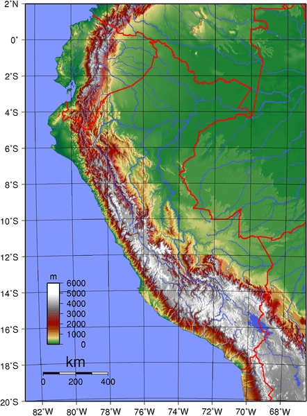
Topographic map of Peru.
Mountain Ranges
Peru hosts a diverse and awe-inspiring array of mountain ranges that form part of the more extensive Andes mountain range. These ranges stretch from north to south, shaping the country's topography and providing a home to unique ecosystems and cultural heritage.
See more: Mountain Ranges of Peru
Islands and Archipelagos
Peru is known for its diverse landscapes, including islands scattered along its Pacific coastline and lakes. While not as renowned for its islands and archipelagos as some other countries, Peru has several notable ones contributing to its biodiversity and cultural diversity.
See more: Islands and Archipelagos of Peru
Bodies of Water
Peru is blessed with many diverse bodies of water, including rivers, lakes, lagoons, gulfs, and bays. These water bodies are crucial for ecosystems and vital for sustaining livelihoods, supporting agriculture, and promoting tourism in this diverse and geographically rich country.
See more: Water Bodies of Peru
Administrative Divisions
Peru has been divided administratively into 25 regions (formerly known as departments) subdivided into provinces, except for the Lima Province, which does not belong to a region. One hundred ninety-six provinces are further subdivided into districts.
See more: Cultural Landscape of Peru
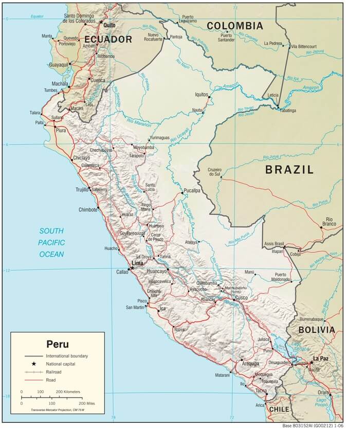
Peru physiographic map.
Natural Regions
Peru's biodiversity can be organized into four main biomes:
- Amazon
- Andean Highlands
- Drylands
- Tropical and Subtropical Dry Broadleaf Forest
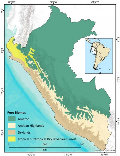
Map of Peru and its four biomes.
Ecological Regions
The following is a list of terrestrial ecoregions in Peru, as defined by the World Wide Fund for Nature (WWF). Peru is in the neotropical realm. Ecoregions are classified by biome type—the major global plant communities determined by rainfall and climate.
Tropical and subtropical moist broadleaf forests
Eastern Cordillera Real montane forests
Peruvian Yungas
Solimões-Japurá moist forests
Southwest Amazon moist forests
Ucayali moist forests
Tropical and subtropical dry broadleaf forests
Montane grasslands and shrublands
Deserts and xeric shrublands
Mangroves
Gulf of Guayaquil-Tumbes mangroves
Piura mangroves
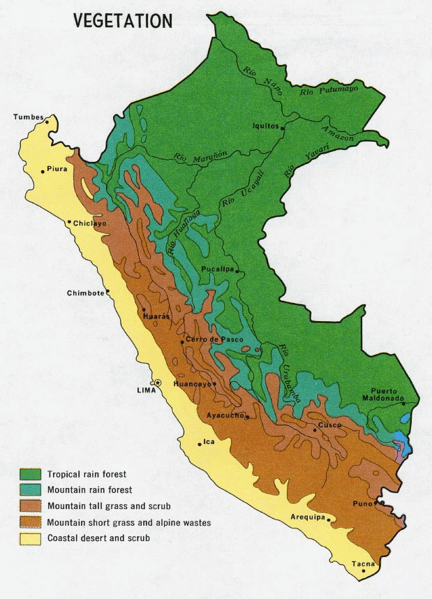
Vegetation map of Peru.