Várzea Forests: Seasonal Floodplain Ecoregions of the Amazon
Várzea forests, part of the expansive Amazon biome, represent one of the planet's most dynamic and complex ecosystems. These floodplain forests, shaped by river levels' annual rise and fall, encompass a rich tapestry of habitats, including dense forests, grasslands, lakes, and floating meadows.
")
")
")

")

Várzea Forests: The Dynamic Seasonal Floodplain Ecoregions of the Amazon
Várzea forests, part of the expansive Amazon biome, represent one of the planet's most dynamic and complex ecosystems. These floodplain forests, shaped by river levels' annual rise and fall, encompass a rich tapestry of habitats, including dense forests, grasslands, lakes, and floating meadows. Spanning vast areas along the Amazon River and its tributaries, these ecosystems are crucial to the region's ecological health and support an incredible diversity of life.
Seasonal Flooding and Hydrological Patterns
At the heart of várzea ecosystems lies the seasonal rhythm of flooding, driven by the rainfall cycles of the Amazon. Whitewater rivers, laden with nutrient-rich sediment from the Andes, swell during the rainy season, causing water levels to rise by as much as 10 to 15 meters (33 to 50 feet). This periodic inundation transforms the landscape, submerging large portions of forest and creating temporary aquatic habitats. The hydrological pulse of the Amazon dictates the life cycles of the plants and animals that inhabit these várzea forests, making these regions a model of ecological resilience and adaptation.
Distinct Ecoregions within the Várzea
The vastness of the Amazon ensures that várzea forests are not monolithic. They vary significantly across the basin, with each region displaying distinct ecological characteristics. For instance, the Iquitos várzea in the upper Amazon experiences less severe flooding than the Purus várzea in the central basin. At the same time, the Marajó várzea, located at the river's mouth, contends with the additional influence of ocean tides. The Monte Alegre and Gurupá várzea regions in the lower Amazon are similarly unique, each shaped by specific flood patterns and topographical features. Together, these distinct ecoregions contribute to the overall complexity and biodiversity of the Amazon.
Diverse Habitat Components
Várzea forests are far more than just forests. About 75% of the landscape is covered by dense canopy forests, but the remaining 25% consists of grasslands, swamps, lakes, and flooded fields, all contributing to the overall mosaic of habitats. This variety stems from the way flooding interacts with topographical variations in the region. Lower areas are flooded for longer periods, giving rise to aquatic environments, while higher areas experience only seasonal submersion, allowing for more traditional forest ecosystems to thrive. This interplay between water and land creates highly productive zones that support a wide range of species.
Ecological Productivity and Breeding Grounds
Várzea forests are among the most productive ecosystems in Amazonia. The annual influx of nutrient-rich waters replenishes the soil, making the várzea ideal for supporting plant growth. This nutrient influx, in turn, provides critical breeding grounds for various species, including fish, birds, mammals, and reptiles. The whitewater floods enable fish to migrate into the submerged forests, where they feed on fruits and other resources. Many species take advantage of this seasonal bounty, making the várzea a vital part of the Amazon's overall ecological health.
Adaptations for Survival in a Flooded World
To survive the dramatic seasonal fluctuations, the flora and fauna of várzea ecosystems have developed unique adaptations. Trees in these regions often possess specialized root systems that allow them to tolerate prolonged periods of submersion. Some fish species have evolved to exploit the submerged forests as breeding and feeding grounds, while animals such as jaguars and monkeys are known to navigate these flooded environments in search of food. Birds, like macaws and parrots, take advantage of the abundant fruit trees that flourish in these nutrient-rich environments. The diverse survival strategies of the region's wildlife underscore the remarkable adaptability of the várzea ecosystem.
Aquatic Advantage for Reproduction
Seasonal flooding provides a critical advantage for aquatic species, particularly fish, by creating vast new areas for reproduction. As waters rise and flood the forest floor, fish can migrate into areas ordinarily inaccessible during the dry season, where they feed on the abundant fruits and seeds that fall from trees. Additionally, the flooded forests offer some protection from predators, which are often confined to smaller, drier areas. This natural ebb and flow of water is central to many aquatic species' reproductive cycles, ensuring the várzea ecosystem's ongoing vitality.
Iquitos Várzea
The Iquitos várzea is a distinctive ecoregion characterized by flooded forests lining the rivers in Brazil, Peru, and Bolivia, situated west of the Amazon biome. The forest experiences seasonal flooding, reaching heights of up to 7 meters (23 feet), courtesy of whitewater rivers carrying nutrient-rich sediment from the Andes.
The meandering rivers contribute to a dynamic and ever-changing landscape. Oxbow lakes, marshes, levees, and bars intermingle with grasslands, shrubs, and forests in various stages of succession. During extended flood periods, fish venture into the woods, driven by the quest for fruit amidst the submerged terrain.
Navigable rivers crisscross the region, making the forest accessible. However, this accessibility has also exposed the area to extensive deforestation. Timber extraction and the creation of pastures for livestock have left their mark on this ecologically sensitive region.
Encompassing the low, seasonally inundated river basins of the upper Amazon, Ucayali, Marañón, and Madre de Dios in Peru and Bolivia, this ecoregion includes several smaller tributaries to the Amazon in Peru and the upper Juruá and Purus rivers in Brazil.
Most of the Iquitos várzea revolves around the expansive seasonally flooded plain in northeastern Peru, where the Marañon and Ucayali rivers converge to form the Amazon. The Pacaya and Simiria rivers cut through this plain, creating a diverse and intricate landscape.
Iquitos, a major urban center, sits at an elevation of 100 meters (328 feet). The overall topography is characterized by flat terrain with micro-undulations resulting from the meandering course of the rivers.
The Iquitos Varzea is not merely a snapshot of seasonal inundation but a nuanced interplay of water dynamics, landscape complexity, and human impact. As accessibility and deforestation pose challenges, this ecoregion's delicate balance underscores the importance of sustainable practices to preserve its ecological integrity.
Flora and Fauna
Within the Iquitos Varzea ecoregion, characteristic trees such as the buriti palm and Jessenia batuaua define the landscape. Along the water's edge, shrubs bearing the camu-camu fruit thrive amidst seasonal flooding. The understory is adorned with the dominance of Heliconia and ginger, accompanied by the presence of palms and epiphytes.
This ecoregion is a haven for over 225 mammalian species, showcasing the richness of its aquatic and terrestrial habitats. Marine wonders like the boto, manatee, and giant otter find their home here. Other noteworthy mammals include Goeldi's marmosets, Andean night monkeys, monk sakis, spiny rats, and at least four opossum species.
The Iquitos Varzea hosts a staggering 624 bird species, making it an integral part of the Upper Amazon-Napo lowlands Endemic Bird Area. Within this avian tapestry, nine species stand out as endemic restricted-range birds, featuring unique inhabitants such as the Cocha antshrike, black-tailed antbird, and white-masked antbird.
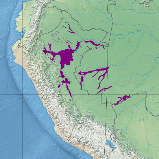
Map depicting the location of the Iquitos várzea (in purple).
Purus Várzea
The Purus Varzea is a region of flooded forests situated in the central part of the Amazon Basin. This area is characterized by vegetation that has adapted to endure floods of up to 12 meters (39 feet), which persist for about eight months.
Though mammal diversity is relatively lower, the ecosystem harbors various fish and bird species. Ground-dwelling mammals often migrate to higher ground during the flood season to cope with the inundation.
The Purus Varzea faces multiple threats, including logging, cattle farming, over-fishing, and mercury pollution from gold mining. These human-induced pressures challenge the region's ecological balance, necessitating conservation efforts.
Flora and Fauna
The avifauna is notable, boasting over six hundred thirty bird species. However, the habitat's frequent flooding influences the diversity of terrestrial mammals, which is comparatively more minor. Two narrow endemic primates inhabit this region: the white uakari monkeys (Cacajao calvus calvus) and blackish squirrel monkeys (>Saimiri vanzolinii). The largest snake globally, the great anaconda (>Eunectes murinus), also lives here.
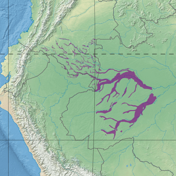
Map depicting the location of the Purus várzea (in purple)
Monte Alegre Várzea
The Monte Alegre várzea is a distinctive ecological region characterized by seasonal flooding in the lower Amazon basin characterized by seasonal flooding. Located in Brazil, this várzea extends along the Amazon River and its tributaries, contributing to the intricate mosaic of landscapes that define the Amazon biome.
This várzea is situated downstream along the Amazon River, encompassing portions of the lower basin. It is part of the broader Amazon biome, renowned for its unparalleled biodiversity and unique ecological dynamics.
The defining feature of the Monte Alegre várzea is its seasonal flooding. The region experiences a cyclical rise and fall of water levels, influenced by the annual rainy and dry seasons. During the wet season, water levels can surge significantly, transforming the landscape into a vast flooded area expanse.
The Monte Alegre várzea is a diverse habitat comprising flooded forests and open areas such as grasslands and meadows that become inundated during the wet season. This ecosystem variety contributes to the overall richness of the region's flora.
Similar to other várzea ecosystems, the Monte Alegre várzea faces conservation challenges. Human activities, including deforestation, agriculture, and infrastructure development, threaten the delicate balance of this flooded ecosystem. Conservation efforts are crucial to ensure the sustained health of the Monte Alegre várzea and its unique biodiversity.
Flora and Fauna
Biodiversity is exceptionally high in this flooded forest along the lower Amazon. In terms of avifauna, there are 681 reported bird species, including red-shouldered macaws (Ara nobilis), sun parakeets (Aratinga solstitialis) and green-rumped parrotlets (Forpus passerinus). Over two hundred species of mammal are found here, including jaguars (Panthera onca), ocelots (Leopardus pardalis), tapirs (Tapirus terrestris), and several primate species.
The vegetation in this várzea showcases a mix of plant species adapted to periodic inundation. Trees with specialized root systems, aquatic vegetation, and adaptable understory plants contribute to the ecological tapestry. The seasonal flooding provides essential nutrients, making the Monte Alegre várzea a productive breeding ground for various species of fish, birds, mammals, and reptiles.
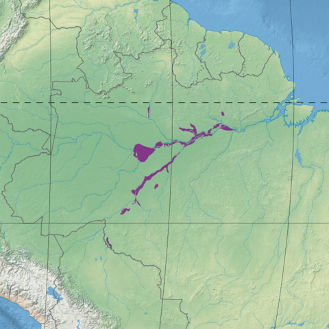
Map depicting the location of the Monte Alegre várzea (in purple).
Gurupa Várzea
The Gurupa várzea is a notable ecoregion within the Amazon biome characterized by lush forests and seasonal flooding along the Amazon River. The ecoregion draws its name from the Ilha Grande de Gurupá, an alluvial island located at the mouth of the Amazon.
Extending along the lower Amazon River from the Tapajós River mouth to the Xingu River mouth, the Gurupa várzea covers an expansive area totaling 984,195 hectares (2,432,000 acres). Positioned strategically between the Tapajós-Xingu moist forests to the south and the Uatuma-Trombetas moist forests to the north, it also neighbors the upstream Monte Alegre várzea and the downstream Marajó várzea along the Amazon.
The flooded forests of the Gurupa várzea showcase the remarkable adaptability of its resident species. During seasonal and tidal fluctuations, trees, grasses, and shrubs gracefully endure partial submersion underwater for extended periods, attesting to the resilience of the ecosystem.
In response to the cyclic floods, animals and fish exhibit synchronized movements to and from the area, capitalizing on the abundant fruits produced by the resilient trees. This dynamic interaction fosters diverse resident species within these tropical savannas, including notable inhabitants like the scaled spinetail.
The Gurupa várzea plays a crucial role within the larger Amazon biome, acting as a transitional zone between different moist forest ecoregions. Its position along the lower Amazon River makes it a vital hub for ecological processes, influencing the biodiversity and adaptability of the surrounding landscapes.
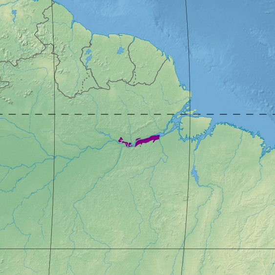
Map depicting the location of the Gurupa várzea (in purple).
Marajó Várzea
The Marajó várzea ecoregion unfolds as a distinctive landscape of sedimentary islands and floodplains at the mouth of the Amazon River in eastern Brazil. This unique area experiences bi-daily flooding, courtesy of ocean tides pushing river waters onto the land, resulting in the proliferation of numerous islands across the region.
The ecoregion's flooded terrain is a vital habitat for diverse ecosystems, twice daily inundated by ocean tides. This constant ebb and flow creates a dynamic environment that supports fruit-eating fish, aquatic mammals, birds, and other fauna. The absence of protected areas places this region under imminent threat from activities such as cattle and water buffalo ranching, logging, and fruit plantations.
The Marajó Várzea is a natural reservoir for nutrient-rich soils carried downstream by the Amazon River. The twice-daily tidal flooding influences the region's topography and its ecological characteristics. Consequently, vegetation in this area tends to be shorter than the surrounding regions, with a lower diversity of plant species, while palms take center stage. However, the fauna diversity is notably richer, with avifauna standing out with around 540 species.
Despite its ecological significance, the Marajó Várzea faces considerable threats, primarily from human activities. Cattle and water buffalo ranching, coupled with large-scale commercial logging, pose imminent challenges to the ecological balance of this ecoregion. The absence of protected areas exacerbates these threats, necessitating urgent attention to safeguard the unique biodiversity within this tidal floodplain.
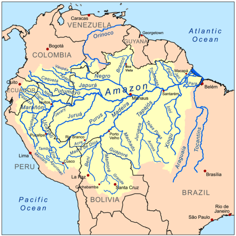
Map of the Amazon River Basin.