Tocantins-Araguaia River System: A Comprehensive Overview of Brazil's Central Fluvial Network
The Tocantins-Araguaia River system in central Brazil is one of the country's most vital and extensive fluvial networks. Though commonly mistaken as a tributary of the Amazon River, this system is distinct and unique, with its complex hydrological dynamics and significant ecological importance.

 https://www.flickr.com/photos/internationalrivers/5643599291")


 https://www.flickr.com/photos/nasa2explore/29644721758")
The Tocantins-Araguaia Watershed: Balancing Development and Conservation in Central Brazil
The Tocantins-Araguaia River system in central Brazil is one of the country's most vital and extensive fluvial networks. Though commonly mistaken as a tributary of the Amazon River, this system is distinct and unique, with its complex hydrological dynamics and significant ecological importance. The river flows northward from the Brazilian Highlands, eventually emptying into the Atlantic Ocean through the Pará River, a distributary channel of the Amazon River delta. The Tocantins-Araguaia system, encompassing an expansive drainage basin of approximately 767,000 square kilometers (296,000 square miles), represents about 7.5% of Brazil's national territory. It is crucial in the country's water resource management, energy production, and biodiversity conservation.
The Tocantins-Araguaia River System: Geographic and Hydrological Features
The Tocantins-Araguaia River system is formed by two primary rivers, the Tocantins and the Araguaia, which together create a watershed that spans multiple Brazilian states, including Tocantins, Goiás, Mato Grosso, Pará, Maranhão, and the Federal District. The system is characterized by its elongated configuration, with altitudes generally ranging between 350 to 500 meters (1,150 to 1,650 feet), though some areas reach elevations exceeding 1,000 meters (3,280 feet).
The Tocantins River, flowing for approximately 2,640 kilometers (1,640 miles), originates in the Serra dos Pireneus and travels through diverse landscapes, including the states of Goiás and Tocantins. The river's course is marked by steep bluffs and broad valleys composed of sand and clay, remnants of great sandstone plateaus. Despite its length, the Tocantins River is of limited use for navigation due to frequent interruptions by rapids and waterfalls.
The Araguaia River, nearly equal in length to the Tocantins, extends for approximately 2,627 kilometers (1,632 miles). Originating in the Serra dos Caiapós, the Araguaia flows northward and parallels the Tocantins River before their confluence. Along its journey, the Araguaia River creates Bananal Island, the world's largest fluvial island, which is a critical ecological zone featuring blackwater river channels, oxbow lakes, and flooded forests.
Tocantins-Araguaia Basin: A Key Hydrological Region
The Tocantins-Araguaia Basin, also known as the Araguaia-Tocantins watershed, covers a vast area of central Brazil and is the second-largest basin in the country in terms of energy production. The basin's geography is dominated by flat, broad valleys and steep bluffs, with river channels deeply incised into the landscape. The basin extends across several Brazilian states and is divided into the Tocantins-Araguaia hydrographic region for water resource management.
The Tocantins River basin alone spans approximately 2,500 kilometers (1,550 miles) from its source in the Serra Dourada to its mouth in Marajó (Pará) Bay. The basin's configuration is predominantly elongated, with elevations typically varying between 300 to 600 meters (980 to 1,970 feet) above sea level, providing diverse habitats and ecosystems.
Ecological Significance: Biodiversity and Endemic Species
The Tocantins-Araguaia Basin is ecologically significant, encompassing regions of the Amazon biome and home to a rich diversity of flora and fauna. The middle and lower river basins fall within the Xingu-Tocantins-Araguaia moist forests ecoregion, a crucial part of the Amazon Rainforest. However, the Araguaia River itself is not a tributary of the Amazon River, which adds to the uniqueness of this ecosystem.
The lower reaches of the Tocantins River serve as a natural barrier between two major ecoregions: the Tocantins-Araguaia-Maranhão moist forests to the east and the Xingu-Tocantins-Araguaia moist forests to the west. This barrier effect prevents species dispersal between these regions, resulting in a high degree of endemism.
The basin is home to several large aquatic mammals, such as the Amazonian manatee, the Araguaia river dolphin (Inia araguaiaensis), and the tucuxi (Sotalia fluviatilis). The presence of large reptiles, including the black caiman (Melanosuchus niger), spectacled caiman (Caiman crocodilus), and the yellow-spotted river turtle (Podocnemis unifilis), further highlights the basin's ecological importance.
Fish diversity in the Tocantins-Araguaia Basin is equally impressive, with over 350 species documented, over 175 of which are endemic to the region. The most species-rich families include Characidae (tetras and allies), Loricariidae (armored catfish), and Rivulidae (South American killifish). While most species are of Amazonian origin, some also show connections with the Paraná and São Francisco river systems, reflecting the basin's complex biogeographical history.
Human Impact and Conservation Challenges
The Tocantins-Araguaia River system is integral to the livelihoods of millions who rely on its waters for agriculture, fishing, transportation, and hydroelectric power. The river system's vast potential for energy production has led to the construction of several major dams, such as the Tucuruí and Serra da Mesa dams, which have significantly altered the river's flow and impacted the surrounding ecosystems.
While essential for regional development, these dams pose challenges to conservation efforts. The alteration of natural flow regimes has disrupted fish migration patterns, reduced sediment transport, and affected the biodiversity of aquatic and riparian habitats. Moreover, the expansion of agriculture and deforestation in the basin further threatens the delicate balance of these ecosystems.
Conservation efforts in the Tocantins-Araguaia Basin are crucial for preserving its unique biodiversity and maintaining the ecological services it provides. Protecting critical habitats, such as the Bananal Island wetlands and the lower Tocantins River floodplains, is vital for the survival of many endemic species and the basin's overall health.
Conclusion
The Tocantins-Araguaia River system is a vital component of Brazil's central fluvial network, with immense ecological, hydrological, and economic significance. From its origins in the Brazilian Highlands to its discharge into the Atlantic Ocean, the system supports diverse ecosystems, including unique fish species, mammals, and reptiles. The Tocantins-Araguaia Basin's rich biodiversity, coupled with its role in energy production and water resource management, underscores the need for sustainable development and conservation strategies to ensure the long-term health of this critical river system.
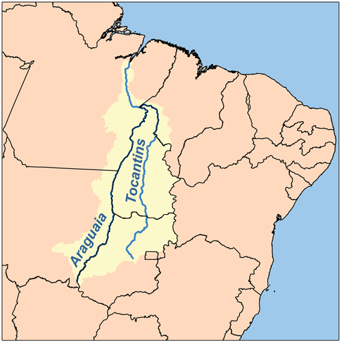
Map depicting the Araguaia-Tocantins watershed.