
The Madeira River: From the Bolivian Lowlands to the Amazon
The Madeira River forms in Bolivia where the Beni and Mamoré meet, then flows north along the Brazilian border and across Rondônia and Amazonas to the Amazon. One of the Amazon's two largest tributaries, it carries enormous loads of Andean sediment, supports migratory fish, and now runs through two giant hydroelectric dams.


The Madeira River: Andean Waters, Falls, and Dams on the Amazon's Great Southern Tributary
The Madeira River drains much of Bolivia, southeastern Peru, and southwestern Brazil, then joins the Amazon about 145 kilometers (90 miles) east of Manaus. The river proper is about 1,450 kilometers (900 miles) long, but it is usually measured with its main headstream, the Mamoré, bringing the total to roughly 3,250 to 3,380 kilometers (2,020 to 2,100 miles). By water volume, it is one of the two largest tributaries of the Amazon; by sediment, it is probably the largest, because its upper basin reaches deep into the Andes.
Formation and Course
The Madeira begins at Villa Bella, Bolivia, where the Beni and Mamoré rivers meet. The Beni and Mamoré are major rivers in their own right: the Beni drains a basin of about 282,000 square kilometers (109,000 square miles) with a mean flow near 9,300 cubic meters per second (328,000 cubic feet per second). Further upstream, the Madre de Dios River rises in the Peruvian Andes and joins the Beni near Riberalta, so the Madeira system reaches into both Peru and Bolivia. The Mamoré collects water from the eastern slopes of the Bolivian Andes and then crosses the wetlands of the Beni lowlands, where it receives the Guaporé, also called the Iténez.
From Villa Bella, the Madeira flows north for about 100 kilometers (60 miles) as the border between Bolivia and Brazil. Below the Abunã River, it turns northeast and runs entirely through Brazil, crossing Rondônia and Amazonas. Its main tributaries there include the Jamari, Ji-Paraná, Manicoré, and Aripuanã; near the mouth, a distributary channel feeds the marshy islands known as Tupinambaranas. Published lengths for the stretch within Brazil vary, which is one reason the river is often described with a range of figures.
Basin and Flow
The basin covers about 1.38 million square kilometers (533,000 square miles), shared mainly by Bolivia and Brazil, with a smaller part in Peru. Just below its formation, the Madeira already carries a mean flow of about 18,000 cubic meters per second (640,000 cubic feet per second). By the time it reaches the Amazon, the average has risen to about 31,200 cubic meters per second (1.1 million cubic feet per second), with recorded extremes from about 2,350 to 52,800 cubic meters per second (83,000 to 1.86 million cubic feet per second). It contributes between 13 and 15 percent of the Amazon's total flow, depending on the study.
The upper basin includes the Llanos de Moxos, a seasonally flooded plain of the Beni Savanna where raised fields and causeways record centuries of human water management. Summer rains, mostly from November to April, swell the Andean rivers and flood these plains, and the pulse then travels downstream into Brazil.
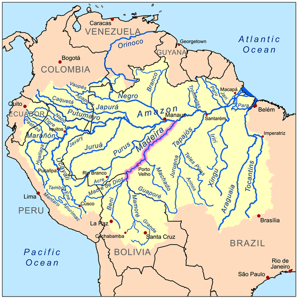
Map depicting the Amazon River drainage basin with the Madeira River highlighted.
Sediment and Whitewater
The Madeira is a classic whitewater river, muddy and rich in nutrients, because the Andes erode quickly. Measurements from a ten-year monitoring program put its suspended sediment load near the Amazon at about 430 million metric tons per year (about 474 million US tons), and the Andean part of the basin alone is estimated to produce about 640 million metric tons per year. Some estimates suggest the Madeira may supply up to half of the sediment that the Amazon delivers to the Atlantic. Several of its tributaries, such as the Aripuanã and Ji-Paraná, run clear, and others, such as the Manicoré, run black, so the river is a mosaic of water types where they meet.
Floods and Droughts
Water levels at Porto Velho swing widely. In March 2014, heavy rain in the Bolivian headwaters sent the river to a record of about 19.7 meters (65 feet), more than 2 meters (7 feet) above the previous high of 1997, and floods displaced thousands of people in Rondônia. A decade later, the opposite extreme arrived. In the drought of 2023 and 2024, the river fell below 1.1 meters (3.6 feet) and then, on September 23, 2024, to a record low of 25 centimeters (about 10 inches) at Porto Velho, the lowest since measurements began in 1967. The port there suspended operations for the first time, and barge traffic, fuel supplies, and communities that depend on the river were disrupted.
Rapids, Railway, and Navigation
Ocean-going vessels can travel up the Madeira from the Amazon as far as the Santo Antônio falls near Porto Velho, a distance of more than 1,000 kilometers (620 miles). Above that point lay 19 falls and rapids that blocked navigation for about 360 kilometers (225 miles) up the Madeira and Mamoré. To bypass them, Brazil built the Madeira-Mamoré Railroad between 1907 and 1912, a 365-kilometer (227-mile) line from Porto Velho to Guajará-Mirim, promised to Bolivia in the Treaty of Petrópolis in 1903, when Bolivia ceded the territory of Acre to Brazil. Thousands of workers died of disease, accidents, and violence during its construction, and estimates range from several thousand to more than 6,000. The railroad was abandoned in 1972, after the Trans-Amazonian Highway and later roads made it redundant.
Today, the river is a major freight route for grain and fuel to and from Porto Velho, and its low-water season, generally from June to November, restricts vessel draft.
Peoples and the Rubber Era
The basin is among the most linguistically diverse parts of the Amazon, with Indigenous peoples speaking Arawakan, Tupian, Panoan, and Chapacuran languages as well as several isolates. Some groups in Rondônia, including those near the Uru-Eu-Wau-Wau territory, live in areas under pressure from mining and land invasions. The rubber boom, which lasted from the late 1800s to about 1912, drew migrants, merchants, and rubber tappers into the valley, and it devastated Indigenous populations such as the Harakbut of the Madre de Dios. Later colonization, cattle ranching, and soybean farming expanded from Rondônia and the Bolivian lowlands, while Porto Velho, now a city of roughly 460,000 people, grew up around the river port and the railroad.
Fish and Wildlife
The basin's fish count ranges from about 750 to more than 900 species, making it one of the richest freshwater systems on Earth. Giant catfish such as the dourada (Brachyplatystoma rousseauxii) and the piramutaba (Brachyplatystoma vaillantii) travel more than 3,000 kilometers (1,900 miles) from the Amazon estuary to spawn in the Andean headwaters of the Madeira system, and their offspring drift back down to the sea. The forests and wetlands shelter the jaguar (Panthera onca), giant otter (Pteronura brasiliensis), and Amazon river dolphin (Inia geoffrensis), and the valley's traditional livelihoods include fishing and gathering Brazil nuts (Bertholletia excelsa) and rubber from the rubber tree (Hevea brasiliensis). The wider setting is described in the articles on the Amazon Basin and Amazônia.
The Madeira Dams
Two large run-of-the-river dams now stand on the Madeira near Porto Velho. Santo Antônio, at the city, has an installed capacity of about 3,570 megawatts, and Jirau, roughly 100 kilometers (60 miles) upstream, has 50 turbines of 75 megawatts each for a total of 3,750 megawatts. Environmental licenses were issued in 2007, Jirau's construction began in December 2008, and Jirau began generating power between 2013 and 2016. A transmission line carries the power across more than 2,000 kilometers (1,200 miles) to southeastern Brazil. The Santo Antônio reservoir drowned the Teotônio and Santo Antônio falls, and plans for two more dams, one on the Bolivian border and one inside Bolivia, have not been built.
The dams were controversial from the start. Fish ladders were installed, but biologists warned that migratory catfish might not be able to climb them or return downstream, and studies since then have found changes in fisheries yields on the floodplain and along tributaries as far upstream as Bolivia's Ichilo River. Critics also pointed to the sediment trapped behind the dams, the displacement of riverside families, and the labor conditions during construction.
Gold Mining and Mercury
Gold mining has long been part of the Madeira's history. Mining in the river channel near Porto Velho dates to the 1970s and was banned in 1991, but a large fleet of dredges returned in 2021, when a state decree regulating mining in rivers encouraged a rush. In 2023 and 2024, federal agencies destroyed 1,222 dredges in Amazonas, 800 of them on the Madeira, including 459 in August 2024 alone, 100 of which were in Indigenous territories. Satellite images showed about 130 new dredges on the river between Novo Aripuanã and Humaitá in January 2025, and in June 2026 federal police and Ibama destroyed 29 more in Rondônia.
Dredging stirs up sediment and releases mercury, which miners use to separate gold. Brazil produces no mercury of its own, and prosecutors estimate that about 185 metric tons of mercury of unknown origin were used in the country's gold mines between 2018 and 2022, with smuggling routes passing through Riberalta in Bolivia and Madre de Dios in Peru. Mercury moves up the food chain into the fish that riverside people eat.
Outlook
The Madeira ties together the Andes, the Bolivian wetlands, and the central Amazon, and the effects of changes anywhere along the river can travel a long way. Its future depends on how hydroelectric operations treat migratory fish and sediment, whether illegal mining can be controlled at its source, and how well Bolivia, Brazil, and Peru coordinate in a basin that is rapidly warming, with more severe floods and droughts. The river also connects to cities such as Manaus, which lies just downstream on the Amazon, and the way it is managed will shape the water, food, and energy of millions of people.
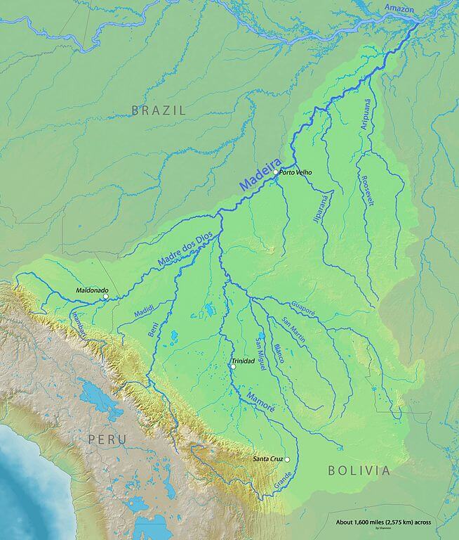
Map depicting the Madeira River watershed in Brazil, Bolivia, and Peru.