The Tapajós River: A Lifeline in the Heart of the Amazon
The Tapajós River, one of the major tributaries of the Amazon River, is a vital watercourse in Brazil. It flows predominantly north/northeast through the Amazon Rainforest. One of the largest clearwater rivers in the world, it plays a crucial role in the hydrology, ecology, and economy of the Amazon Basin.

 via Wikimedia Commons")


 https://www.flickr.com/photos/flavioeiro/3824177951/")

The Tapajós and Its Tributaries: Guardians of Amazonian Biodiversity
The Tapajós River, one of the major tributaries of the Amazon River, is a vital watercourse in Brazil, flowing predominantly north/northeast through the Amazon Rainforest. It is formed by the union of the Juruena and Teles Pires rivers, both of which originate in the Mato Grosso region. Known as one of the largest clearwater rivers in the world, the Tapajós plays a crucial role in the hydrology, ecology, and economy of the Amazon Basin.
Course of the Tapajós River
The Tapajós River meanders north-northeastward, cutting through the dense vegetation of the Amazon Rainforest and traversing the expansive Mato Grosso plateau. The river spans approximately 650 kilometers (400 miles) from where the Juruena and Teles Pires rivers converge to where it empties into the Amazon River near the city of Santarém. However, if one includes the length of the Juruena River, the Tapajós reaches an impressive total length of about 2,080 kilometers (1,290 miles).
As the river approaches its mouth, it widens significantly, spanning 12 to 16 kilometers (8 to 10 miles) across. The last 300 kilometers (186 miles) of the Tapajós, from Maranhão Grande to its confluence with the Amazon River, are navigable by large vessels, making this stretch an essential waterway for transportation and commerce. Santarém, the only major urban center along the river, serves as a critical port and gateway to the broader Amazon region.
The Tapajós Basin
The Tapajós Basin, covering approximately 492,000 square kilometers (190,000 square miles), is the fifth-largest tributary basin in the Amazon River system. The basin accounts for about 7% of the Amazon Basin and lies primarily within the Brazilian states of Mato Grosso and Pará. This vast basin is situated mainly on the Brazilian Shield. It is characterized by its rich and diverse habitats, which include extensive areas of rainforest and savanna known as the Cerrado.
The Tapajós Basin is a region of immense ecological significance. Two-thirds of the basin is covered by dense rainforest, while the remaining third comprises the Cerrado. This tropical savanna is among the most biologically diverse ecosystems on the planet. The basin is home to over 300 identified fish species, making it one of the top regions globally for conserving rare aquatic and terrestrial species. The biodiversity of the Tapajós Basin underscores its critical role in the health and stability of the Amazon Rainforest as a whole.
Teles Pires River
The Teles Pires River, also known as the São Manuel or São Manoel River, is one of the key tributaries contributing to the Tapajós River's formation. Originating as the Paranatinga River in the Serra Azul, which forms part of the Amazon-Paraguay River divide in central Mato Grosso, the Teles Pires flows north-northwestward for approximately 1,400 kilometers (870 miles). Along its course, the river is frequently interrupted by falls and rapids, which add to its rugged and untamed character.
The Teles Pires River is significant for its contribution to the Tapajós River and its role in the broader hydrological network of the Amazon Basin. Despite the challenges posed by its numerous rapids and waterfalls, the river remains an essential waterway for the region's indigenous communities and wildlife.
Juruena River
The Juruena River, another major tributary of the Tapajós, originates in the Parecis Plateau in west-central Brazil. The river flows for approximately 1,240 kilometers (770 miles) through the states of Mato Grosso and Amazonas. For the final 190 kilometers (120 miles) of its course, the Juruena forms the border between these two states before joining the Teles Pires River to create the Tapajós.
The Juruena River is renowned for its dramatic waterfalls and rapids, which make it largely non-navigable. Among these is the Salto Augusto Falls, one of the most notable natural features along the river. The rugged nature of the Juruena River contributes to its pristine condition, providing a critical habitat for various species of flora and fauna within the Amazon Rainforest.
Ecological and Economic Importance
The Tapajós River and its basin are ecologically rich and economically vital to the region. The river is a major transportation route, particularly in its lower reaches near Santarém, where it facilitates the movement of goods and people. The basin's diverse habitats support a wide array of plant and animal species, many of which are of significant ecological and conservation value.
Moreover, the Tapajós Basin is home to several Indigenous communities whose livelihoods are deeply intertwined with the river and its surrounding ecosystems. These communities rely on the river for fishing, agriculture, and transportation and play a crucial role in the stewardship of the region's natural resources.
Conclusion
The Tapajós River and its expansive basin are integral components of the Amazon River system, playing a vital role in the region's hydrology, ecology, and economy. From its origins in the Mato Grosso plateau to its confluence with the Amazon near Santarém, the Tapajós traverses a landscape of extraordinary beauty and biodiversity. The river's tributaries, the Teles Pires and Juruena, further enhance its ecological significance, making the Tapajós Basin a critical area for conservation and sustainable development within the Amazon.
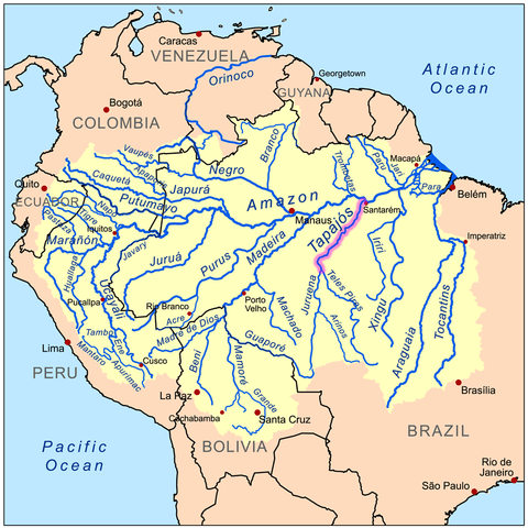
Map depicting the Amazon River drainage basin with the Tapajós River highlighted.