Caquetá-Japurá River: A Vital Amazonian Watercourse
The Caquetá-Japurá River, known as the Caquetá in Colombia and the Japurá in Brazil, is a significant tributary of the Amazon River. Its extensive basin is crucial in the region's hydrology and ecology. It covers a vast area and is characterized by diverse ecosystems, including extensive wetlands.
 https://www.flickr.com/photos/diegolizcano/14734615260")


Exploring the Caquetá-Japurá Basin: Colombia and Brazil's Amazonian Lifeline
The Caquetá-Japurá River, known as the Caquetá in Colombia and the Japurá in Brazil, is one of the significant tributaries of the Amazon River. Spanning approximately 2,820 kilometers (1,750 miles), the river flows through Colombia and Brazil, playing a crucial role in the hydrology and ecology of the Amazon Basin. Its extensive basin covers a vast area in both countries and is characterized by diverse ecosystems, including some of the most extensive wetlands in the Amazon.
Course of the Caquetá-Japurá River
The Caquetá River originates in the southwest of Colombia, near the headwaters of the Magdalena River in the Colombian Andes. From its source, the river flows east-southeastward through Colombia, meandering through the departments of Caquetá and Amazonas. As it journeys through this region, the river passes through a landscape of dense rainforests and remote wilderness, shaping the lives of the indigenous communities and wildlife that depend on it.
A significant tributary, the Apaporis River, joins the Caquetá at the Colombian-Brazilian border. The Apaporis River, known for its blackwater characteristics and striking waterfalls and rapids, contributes substantially to the flow and character of the Caquetá. Once the river crosses into Brazil, it takes on the name Japurá and continues its journey eastward.
In Brazil, the Japurá River flows with a strong current, navigating through a network of channels and large islands as it approaches its confluence with the Solimões, the upper course of the Amazon River. The mouth of the Japurá forms an intricate web of seasonal lakes and flooded forests, making it one of the Amazon's most dynamic and ecologically rich regions. The Japurá River is the Amazon's fourth-largest tributary, underscoring its significance within the vast river system.
The Caquetá-Japurá Basin
The Caquetá-Japurá Basin is one of the major tributary basins within the Amazon River system, covering a substantial portion of Colombia and Brazil. Approximately 80% of the basin lies within Colombia, particularly in the departments of Caquetá and Amazonas, while the remaining 20% is situated in the Brazilian state of Amazonas. The basin is the ninth-largest tributary basin in the Amazon, reflecting its importance in the region's hydrology.
The basin experiences a wide range of precipitation, with annual rainfall varying from about 2,300 millimeters (90 inches) near the mouth of the Japurá to over 3,000 millimeters (118 inches) in the middle and upper reaches of the Caquetá River. In the foothills of the Colombian Andes, where the river originates, average annual rainfall can exceed 5,000 millimeters (200 inches), making this area one of the wettest regions in the Amazon Basin.
The northwestern portion of the Caquetá Basin includes the high Cordillera Oriental and an extensive eastern foothill region that generally lies below 500 meters (1,640 feet) in elevation. This varied topography contributes to the basin's diverse ecosystems, which range from montane forests in the Andes to lowland rainforests and floodplains in the Amazon.
For much of its length, the Caquetá River meanders widely, creating extensive floodplains vital for the region's biodiversity. In the lower 200 kilometers (125 miles) of the Japurá River, the basin merges with the floodplain of the Amazon River (Solimões), forming one of the most extensive wetlands in the Amazon. This area is dominated by flooded forests, known locally as várzea, among the Amazon's most productive and biodiverse ecosystems.
Ecological and Cultural Significance
The Caquetá-Japurá River and its basin are vital components of the Amazon's hydrological system and essential for the region's ecological and cultural heritage. The basin supports a rich array of plant and animal species, many of which are endemic to the area. The extensive wetlands and floodplains at the river's mouth provide critical habitat for fish, birds, and other wildlife, making the region a key area for conservation efforts.
Moreover, the river and its tributaries are integral to the lives of the indigenous communities who have inhabited the region for centuries. These communities rely on the river for transportation, fishing, and agriculture, and they have developed a deep cultural connection to the land and water. The preservation of the Caquetá-Japurá Basin is thus not only crucial for maintaining the region's biodiversity but also for sustaining the cultural heritage of its people.
Conclusion
The Caquetá-Japurá River and its extensive basin are essential to the Amazon River system. From its origins in the Colombian Andes to its confluence with the Solimões in Brazil, the river plays a vital role in the Amazon's ecology and hydrology. The basin's diverse ecosystems, ranging from Andean foothills to Amazonian floodplains, support a wide array of species and provide essential resources for Indigenous communities. The Caquetá-Japurá River is a major tributary of the Amazon and a lifeline for the region's people and wildlife.
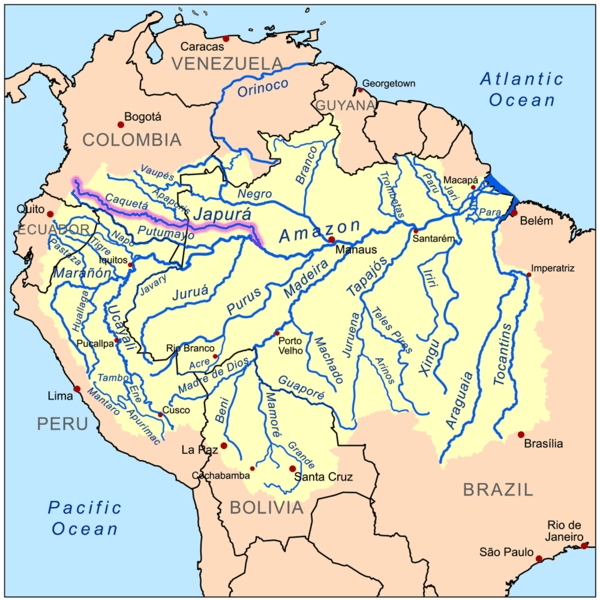
Map depicting the Amazon River drainage basin with the Caquetá-Japurá River highlighted,