Venezuela: Natural Landscape
Venezuela is located on the northern coast of South America, bordering the Caribbean Sea and the Atlantic Ocean in the north and northeast. The country has four distinct geographical regions: the Venezuelan Highlands, the Maracaibo Lowlands, the Orinoco Plains, and the Guiana Highlands.

 Merida state Venezuela - by Alejandro Barrios, CC BY-SA 3.0, via Wikimedia Commons")
 https://www.flickr.com/photos/aztlek/34167176705")

 - by Inti, CC BY 2.0, via Wikimedia Commons")
 https://www.flickr.com/photos/stignygaard/42875169812")


 https://www.flickr.com/photos/waltervargas/16000918132")

The Natural Landscape of Venezuela
Venezuela, positioned on the northern coast of South America, boasts a strategic maritime presence. It is bordered by the Caribbean Sea and the Atlantic Ocean to the north and northeast, respectively. Guyana demarcates the country's land boundaries to the east, Brazil to the south, and Colombia to the west and southwest. To the northwest, Venezuela maintains a maritime border with Trinidad and Tobago.
Venezuela's distinctive landmass, taking the approximate shape of an inverted triangle, encompasses a northern coastline extending approximately 2,800 kilometers (1,700 miles). Diverse geographical features, including numerous bays, peninsulas, and islands, characterize this expansive coastline. Notably, Venezuela exercises jurisdiction over several islands in the Caribbean Sea, contributing to the nation's maritime identity.
Most of Venezuela's major cities are strategically located along the coastline or near significant watersheds. This geographical pattern reflects the historical and economic significance of maritime activities and access to waterways. However, vast expanses such as the Llanos and Guiana Highlands remain sparsely populated, preserving their natural landscapes.
The geographical expanse of Venezuela encompasses tropical regions, with specific areas of the country extending beyond the equator. The Tropic of Cancer traverses the northernmost part of the country, marking the nation's position within the tropics. This geographic diversity contributes to the country's climatic variations and ecological richness.
Venezuela's geographical composition, marked by coastal diversity, vast territories, and an equatorial position, highlights the diverse nature of the nation's landscape. The arrangement of population centers and the conservation of untouched natural habitats illustrate the complex interaction between geography and human settlement in this South American gem.
Climate
Venezuela presents a predominantly hot and humid climate that undergoes modulation with changes in altitude, contributing to a diverse climatic mosaic. The average temperature across the country hovers around 27 ˚C (81 ˚F), but this figure undergoes nuances dictated by regional specifics and altitudinal variations.
Geographical features notably influence the temperature gradient in Venezuela. Coastal areas tend to be warmer, embracing the tropical warmth of the adjacent seas, while the interior regions experience a more temperate climate. The Andean mountains further contribute to this thermal diversity, offering cooler temperatures in contrast to the warmer lowlands.
Annual precipitation levels in Venezuela span a broad spectrum, ranging from 400 mm (16 in) in the arid zones of the northwest to a lush 4,000 mm (160 in) in the country's southern reaches. This remarkable variance in rainfall is a testament to the country's diverse landscapes and geographical intricacies.
Venezuela experiences distinct wet and dry seasons. The wet season unfolds from May to October, bringing substantial rainfall and contributing to the country's rich biodiversity. In contrast, the dry season extends from December through March and is characterized by decreased precipitation. This seasonal dichotomy adds a dynamic element to Venezuela's climate, influencing everything from agriculture to local ecosystems.
Biodiversity
Venezuela is a biodiversity hotspot, celebrated for its rich ecological mosaic shaped by diverse ecosystems and varied topography. According to the Global Biodiversity Index, Venezuela is the 11th most biodiverse country globally.
The statistics speak volumes: 1,386 bird species, 365 amphibian species, 1,735 fish species, 376 mammal species, 419 reptile species, and an estimated 30,000 vascular plant species, collectively elevating Venezuela to the prestigious league of 17 megadiverse countries.
The country's biodiversity can be categorized into the following major ecosystems:
Amazon Basin: A substantial portion of Venezuela resides within the expansive Amazon Basin, fostering a haven for many flora and fauna. Jaguars, tapirs, macaws, and insect and plant species thrive in this vibrant ecosystem, contributing to the nation's remarkable biodiversity.
Orinoco Delta: The extensive Orinoco Delta and surrounding wetlands emerge as crucial aquatic and avian species habitats. Pink river dolphins gracefully navigate these waters alongside caimans, while migratory birds find sanctuary in the wetland expanses.
Andes Mountains: The western expanse of Venezuela is graced by the imposing Venezuelan Andes, creating unique high-altitude ecosystems. Here, spectacled bears, Andean condors, and distinct plant species have adapted to the challenging mountainous terrain.
Gran Sabana: In the southeast, the Gran Sabana unveils a dramatic tableau dominated by table mountains, known as tepuis. This region is a refuge for unique species, such as the tepui toad and the carnivorous tepui pitcher plant, adding a touch of distinctiveness to Venezuela's biodiversity.
Conservation
While the natural wealth is undeniable, Venezuela faces formidable challenges on the conservation front. Political instability and economic difficulties have challenged robust conservation efforts in recent years. Despite these challenges, commendable initiatives persist, driven by the imperative to safeguard the country's unique biodiversity.
Habitat destruction, illegal wildlife trade, and the shadow of political instability loom large on Venezuela's conservation landscape. The nation's conservation trajectory remains intricately tied to its economic and political stability, making ongoing international support and collaboration imperative for preserving its unparalleled biodiversity.
Volcanism
Venezuela experiences minimal volcanic activity, with most volcanoes considered dormant or extinct. Positioned away from tectonic plate boundaries, the country lacks an active volcanic presence in the Pacific Ring of Fire. The geological calmness, influenced by the Andes Mountains and Orinoco River Basin, contributes to Venezuela's stability and distinct geological narrative, providing a relatively stable environment for its diverse ecosystems to thrive.
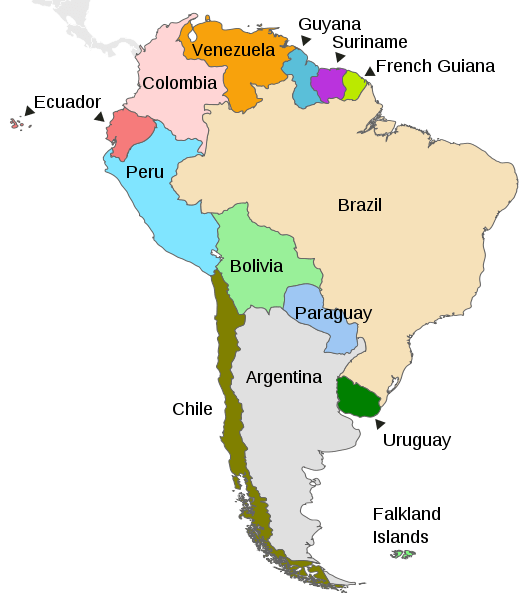
Map depicting the countries on the continent of South America
Natural Geography of Venezuela
Topography
Venezuela's topography can be divided into three broad elevational divisions.
- Lowland Plains: from sea level to elevations of approximately 500 m (1,640 ft)
- Interior Forested Uplands: scattered peaks may rise to 2,000 m (6,560 ft)
- Mountains: elevations may reach up to 5,000 m (16,400 ft)
Seven physiographic regions can be found within them:
- Islands and Coastal Plains: in the north, including the Orinoco Delta in the northeast
- Coastal Mountain System: (with its Coastal and Interior ranges) in the north
- Lake Maracaibo Lowlands: in the northwest
- Mérida and Perijá Ranges of the Andes Mountains: in the northwest
- Northwestern Valleys and Hill Ranges: also known as the Segovia Highlands
- Llanos: in the center of the country
- Guiana Highlands: in the south
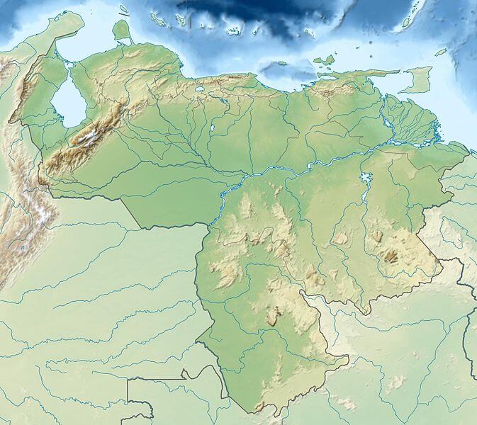
Relief map of Venezuela
Geographical Regions
The country has four distinct geographical regions:
- Venezuelan Highlands: The Venezuelan Highlands are the northeasternmost extension of the Andes Mountains and border the Caribbean Sea. Physiographically, the Segovia Highlands, northwest of Barquisimeto, and the coastal ranges may also be considered parts of the Andes chain. The highest point in the country is Pico Bolivar at 4,978 m (16,332 ft). Its peak is permanently covered in snow. A large portion of the population lives in the valleys between the mountains.
- Maracaibo Lowlands: The Maracaibo Lowlands region in the northwest is relatively flat and surrounded by mountains on three sides. Lake Maracaibo dominates the region, which is known for its oil fields.
- Orinoco Plains: The Orinoco Plains is a lowland grassland region in central Venezuela, known as Los Llanos, with elevations that never exceed 200 m (656 ft). The Orinoco River is a well-known area feature and is the most crucial river in Venezuela.
- Guiana Highlands: The Guiana Highlands (or Guyana Highlands) proper is located in southern Venezuela, east of the Orinoco River. The Gran Sabana is found in this region. Featuring unique geography, the highlands extend into western Guyana and northern Brazil.
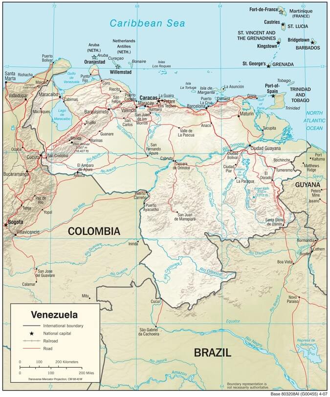
Venezuela physiographic map
Natural Regions
Because of its natural structure, Venezuela can be divided into eight distinct natural regions.
Cordillera de La Costa Region
The Cordillera de La Costa consists of two parallel ranges that run along the central and eastern portions of Venezuela's northern Caribbean coast, divided by a wide bay. The range is a northeastern extension of the Andes, also known as the Maritime Andes. It is the fourth-largest natural region in Venezuela.
Orinoco Delta Region
The Orinoco Delta Region encompasses the vast delta of the Orinoco River. The fan-shaped delta hosts numerous distributaries called caños, which meander their way to the coast. The main distributary is the Rio Grande, which empties through the southeast portion of the delta. The second major distributary is Caño Manamo, which runs northward along the western edge of the delta.
Maracaibo Basin Region
The Maracaibo Basin is located between the high Andean ranges in the country's northwestern corner. Lake Maracaibo, a large shallow tidal estuary, is near its center. The region is hydrocarbon-rich and is one of the country's central oil-producing regions.
Guyana Region
This heavily forested plateau and low-mountain region, the Guyana Highlands, comprises over half of the country. This is where the table-like mountains called tepuis are found and some of the world's most spectacular waterfalls, such as Angel Falls (the world's highest), Kaieteur Falls, and Kuquenan Falls.
Insular Region
The Insular Region comprises the nation's islands and is formed by the state of Nueva Esparta and the Federal Dependencies. Nueva Esparta includes Margarita Island, Coche Island, and the largely uninhabited Cubagua Island. The Federal Dependencies encompass other offshore islands.
Andean Region
The two branches of the Venezuelan Andes, which include the country's highest peaks, are the northeastern extensions of the Colombian Andes' Cordillera Oriental.
- Eastern: The Cordillera de Mérida's eastern branch extends from Colombia's border to the Venezuelan state of Lara and divides the Maracaibo Basin from the Orinoco Basin.
- Western: The western branch, known as the Perijá Mountains (Sierra de Perijá or Serranía de Los Motilones), is a much smaller section that runs along the border with Colombia at the western extreme of the Venezuelan state of Zulia.
Los Llanos Region
Along the course of the Orinoco River lie the Llanos, a relatively level region of savannas and tropical rainforests. The Llanos extend from the Andean foothills to the Orinoco Delta for approximately 1,300 km (800 mi).
Lara-Falcón Highlands Region
The Lara-Falcón Formation or Coriano system Is a hilly and semi-mountainous area in northwest Venezuela. It consists mainly of east-west running ridges, except the Sierra de Siruma or Empalado, which run north-south. The region's coastal plain contains Venezuela's only desert, the Médanos de Coro on the Paraguaná Peninsula.
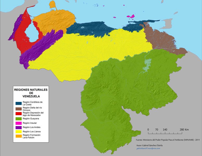
Map depicting the natural regions of Venezuela
Mountain Ranges
Venezuela has diverse mountain ranges that offer stunning landscapes and ecological significance. These mountain ranges contribute to Venezuela's natural beauty, rich biodiversity, and cultural heritage. They provide opportunities for adventure, exploration, and appreciation of the diverse landscapes that make Venezuela a captivating destination for nature enthusiasts and travelers.
See more: Mountain Ranges of Venezuela
Islands and Archipelagos
Venezuela stretches along the northern coast of South America and embraces an assortment of islands and archipelagos that dot the surrounding Caribbean Sea and the Gulf of Venezuela. Steeped in history and ecologically significant, these islands and archipelagos offer an array of landscapes, from pristine white sand beaches to vibrant coral reefs and rugged coastlines.
See more: Islands and Archipelagos of Venezuela
Bodies of Water
The country of Venezuela, situated on the northern coast of South America, has a variety of water bodies that influence its geography, ecosystems, and human activities. Venezuela's waterways are diverse, ranging from the mighty Orinoco River, one of the continent's largest and most significant waterways, to the beautiful Lake Maracaibo, the largest lake in South America. These water bodies are critical to the country, serving as transportation routes, supporting agriculture in the fertile Llanos plains, and providing habitats for various aquatic species.
See more: Water Bodies of Venezuela
Administrative Divisions
Venezuela is a federation of 23 states and a capital district. In addition, a special territory known as the Federal Dependencies encompasses most of the country's offshore islands not already integrated into an existing state. Administratively, the states are divided into 335 municipalities, subdivided into parishes.
See more: Cultural Landscape of Venezuela
Ecological Regions
The following is a list of terrestrial ecoregions in Venezuela, as defined by the World Wide Fund for Nature (WWF). Venezuela is in the Neotropical realm. Ecoregions are classified by biome type - the major global plant communities determined by rainfall and climate.
Tropical and subtropical moist broadleaf forests
- Catatumbo moist forests
- Cordillera de la Costa montane forests
- Cordillera Oriental montane forests
- Guayanan Highlands moist forests
- Guianan moist forests
- Guianan Piedmont and lowland moist forests
- Japurá-Solimões-Negro moist forests
- Negro-Branco moist forests
- Orinoco Delta swamp forests
- Pantepui forests and shrublands
- Venezuelan Andes montane forests
Tropical and subtropical dry broadleaf forests
- Apure-Villavicencio dry forests
- Lara-Falcón dry forests
- Maracaibo dry forests
Tropical and subtropical grasslands, savannas, and shrublands
Flooded grasslands and savannas
Montane grasslands and shrublands
- Cordillera de Merida páramo
Deserts and xeric shrublands
- Araya and Paria xeric scrub
- Guajira-Barranquilla xeric scrub
- La Costa xeric shrublands
- Paraguana xeric scrub
Mangroves
- Coastal Venezuelan mangroves
- Guianan mangroves
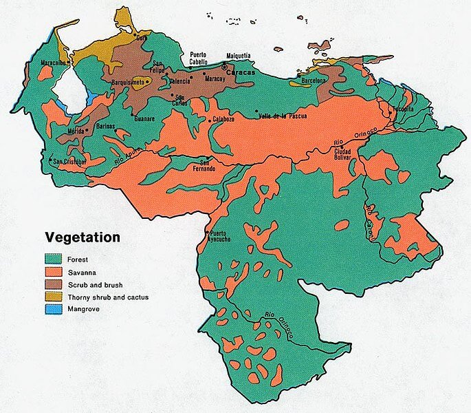
Vegetation map of Venezuela