Venezuela's Majestic Mountain Ranges: A Geographic and Cultural Treasure
Venezuela, rich in geographic diversity, boasts some of South America's most spectacular mountain ranges. From the snow-capped peaks of the Andes in the west to the ancient tepuis of the Guiana Highlands in the south, these formations shape the country's landscape, climate, and culture.
 https://www.flickr.com/photos/davidkjelkerud/219305753")
 Merida state Venezuela - by Alejandro Barrios, CC BY-SA 3.0, via Wikimedia Commons")


From the Andes to the Tepuis: Venezuela's Diverse Mountain Geography
Venezuela, a nation blessed with extraordinary geographic diversity, boasts some of South America's most spectacular mountain ranges. From the snow-capped peaks of the Andes in the west to the ancient tepuis of the Guiana Highlands in the south, these towering formations define much of the country's landscape, climate, and cultural identity. The mountain ranges of Venezuela not only serve as natural barriers and water sources but also harbor unique ecosystems, Indigenous communities, and geological wonders that have captivated explorers and scientists for centuries.
The Cordillera de Mérida: Venezuela's Andean Crown
Geographic Overview and Formation
The Cordillera de Mérida represents the northeastern extension of the mighty Andes mountain chain, stretching approximately 425 kilometers (264 miles) across western Venezuela. This mountain range extends from the Colombian border in the southwest to the Caribbean coastal ranges in the northeast, forming the backbone of Venezuela's Andean region. The cordillera was formed through tectonic uplift and volcanic activity millions of years ago, creating a dramatic landscape of peaks, valleys, and high-altitude plateaus.
The range reaches its maximum width of about 80 kilometers (50 miles) in the central section, where the highest peaks are concentrated. The Cordillera de Mérida is characterized by its rugged terrain, with steep slopes, deep valleys, and U-shaped glacial valleys that tell the story of past ice ages. The mountains rise abruptly from the surrounding lowlands, creating a striking contrast between the tropical zones at their base and the alpine conditions at their summits.
Climate and Ecosystems
The Cordillera de Mérida exhibits remarkable climatic diversity due to its altitudinal range. At lower elevations, tropical conditions prevail with temperatures averaging 24-26°C (75-79°F), while the highest peaks experience sub-alpine and alpine climates with temperatures often dropping below freezing. The range receives significant precipitation, particularly on the windward slopes facing the Caribbean, where annual rainfall can exceed 2,000 millimeters (79 inches).
This climatic diversity supports an extraordinary array of ecosystems, from cloud forests and páramos (high-altitude tropical grasslands) to alpine tundra. The páramos are particularly significant, as they act as natural water reservoirs, storing moisture from clouds and gradually releasing it into the surrounding watersheds. These unique ecosystems are home to endemic species adapted to the harsh high-altitude conditions, including frailejones (Espeletia species), distinctive plants that have become symbols of the Venezuelan Andes.
The Cordillera de la Costa: Caribbean Mountain Barrier
Structure and Extent
The Cordillera de la Costa (Coastal Range) forms a dramatic mountain barrier along Venezuela's Caribbean coast, extending approximately 600 kilometers (373 miles) from the Paraguaná Peninsula in the west to the Paria Peninsula in the east. This ancient mountain system is divided into two main sections: the western and central segments, separated by the lowlands around Lake Valencia and the Tuy River valley.
The range reaches its highest elevations in the central section, where peaks rise to over 2,700 meters (8,858 feet) above sea level. The mountains drop precipitously toward the Caribbean Sea in many areas, creating a spectacular coastline of cliffs, bays, and narrow coastal plains. The southern slopes descend more gradually toward the Llanos, Venezuela's vast central plains.
Geological Significance and Formation
The Cordillera de la Costa represents some of the oldest geological formations in Venezuela, with rocks dating back to the Precambrian era. The range was formed through complex tectonic processes involving the collision and uplift of ancient crustal blocks. Metamorphic rocks, including gneiss and schist, dominate the higher elevations, while sedimentary formations are more common in the foothills and valleys.
This geological diversity has created a varied landscape within the range, ranging from granite outcrops and steep-walled valleys to rolling hills and broad plateaus. The mountains also contain important mineral deposits, including gold, which has been mined in the region since pre-Columbian times.
The Guiana Highlands: Ancient Plateau and Mysterious Tepuis
The World's Oldest Mountains
The Guiana Highlands occupy much of southern and southeastern Venezuela, representing one of the world's oldest geological formations. This vast region, spanning approximately 430,000 square kilometers (166,000 square miles), comprises ancient rocks that date back nearly 2 billion years. The highlands are part of the larger Guiana Shield, which extends into Brazil, Guyana, Suriname, and French Guiana.
Unlike the linear mountain chains of the Andes and Coastal Range, the Guiana Highlands are characterized by a complex topography of plateaus, mesas, and isolated mountain massifs. The region's most distinctive features are the tepuis, flat-topped mountains that rise dramatically from the surrounding lowlands like massive natural skyscrapers.
The Enigmatic Tepuis
The tepuis (from the Pemón word meaning "house of the gods") are among Venezuela's most iconic natural features. These table mountains, formed from ancient sandstone and quartzite, have been isolated for millions of years, allowing unique flora and fauna to evolve in isolation on their summits. Many tepuis support endemic species found nowhere else on Earth, making them natural laboratories for the study of evolutionary biology.
The tepuis vary dramatically in size and height, from small mesa-like formations to massive plateaus covering hundreds of square kilometers. Their vertical walls, often rising 1,000 meters (3,281 feet) or more above the surrounding landscape, create natural fortresses that have preserved pristine ecosystems on their summits. These isolated environments support specialized plant communities, including carnivorous plants, endemic orchids, and unique geological formations.
Canaima National Park and World Heritage Status
Much of the tepui region is protected within Canaima National Park, Venezuela's largest national park and a UNESCO World Heritage Site. The park encompasses 30,000 square kilometers (11,583 square miles) and contains some of the most spectacular tepuis, including Mount Roraima and Auyán-tepui, the latter being the source of Angel Falls, the world's highest uninterrupted waterfall.
The Sierra de Perijá: Border Mountains
Geographic Position and Characteristics
The Sierra de Perijá forms part of Venezuela's western border with Colombia, extending approximately 300 kilometers (186 miles) from the Guajira Peninsula in the north to the Cordillera de Mérida in the south. This mountain range represents the northernmost extension of the Eastern Cordillera of Colombia and serves as a natural boundary between the two nations.
The range reaches elevations of over 3,500 meters (11,483 feet) in its central section, with peaks gradually decreasing in height toward both the north and south. The western slopes drain toward the Magdalena River basin in Colombia, while the eastern slopes feed rivers that flow into Lake Maracaibo and the Caribbean Sea.
Ecological and Cultural Importance
The Sierra de Perijá supports a diverse array of ecosystems, ranging from tropical dry forests at lower elevations to cloud forests and páramos at higher altitudes. The range serves as an important biological corridor, connecting the ecosystems of the Andes with those of the Caribbean coastal region. The mountains also harbor significant biodiversity, including several endemic species of birds, mammals, and plants.
The region is home to various Indigenous communities, including the Yukpa and Barí peoples, who have maintained traditional lifestyles that are well-adapted to the mountainous environment. These communities have deep cultural connections to the mountains, viewing them as sacred spaces and sources of spiritual power.
Major Peaks of Venezuela
Andean Giants
Pico Bolívar stands as Venezuela's highest peak at 4,978 meters (16,332 feet) above sea level, located in the Cordillera de Mérida within Sierra Nevada National Park. Named after South American liberator Simón Bolívar, this peak was formerly topped by the Humboldt Glacier, one of the last remaining glaciers in Venezuela. However, climate change has caused a significant retreat in recent decades.
Pico Humboldt, reaching 4,940 meters (16,207 feet), is the second-highest peak in Venezuela and was named after the famous German naturalist Alexander von Humboldt, who explored the region in the early 19th century. Like Pico Bolívar, it once supported glacial ice, and both peaks are accessible via cable car from the city of Mérida, making them popular destinations for mountaineers and tourists.
Pico La Concha rises to 4,920 meters (16,142 feet), completing the triumvirate of Venezuela's highest summits. All three peaks are located within a relatively small area of the Cordillera de Mérida, creating a dramatic skyline visible from the surrounding valleys.
Coastal Range Summits
Pico Naiguatá, at 2,765 meters (9,072 feet), dominates the central section of the Cordillera de la Costa and overlooks the capital city of Caracas. This peak is particularly significant as it rises directly from near sea level to its summit in a relatively short horizontal distance, creating one of the steepest elevation gradients in the world.
Cerro El Ávila (also known as Waraira Repano), which reaches 2,159 meters (7,083 feet), forms the dramatic backdrop to Caracas and is accessible via a cable car. This mountain is beloved by Caracas residents and serves as a natural escape from urban life, offering hiking trails, cloud forests, and panoramic views of the city and the Caribbean coast.
Tepui Peaks
Mount Roraima, standing at 2,810 meters (9,219 feet), is perhaps Venezuela's most famous tepui and one of the most recognizable mountains in South America. Located at the triple border of Venezuela, Brazil, and Guyana, Roraima inspired Sir Arthur Conan Doyle's novel "The Lost World" and continues to captivate adventurers and scientists with its unique ecosystem and dramatic landscape.
Auyán-tepui, with its highest point at 2,450 meters (8,038 feet), is one of the largest tepuis and the source of Angel Falls. The mountain's name means "house of the devil" in the local Pemón language, reflecting the awe and respect Indigenous peoples have for these massive formations.
Conservation and Environmental Challenges
Protected Areas and National Parks
Venezuela has established an extensive system of national parks and protected areas to preserve its mountain ecosystems. Sierra Nevada National Park protects the highest peaks of the Cordillera de Mérida, while El Ávila National Park safeguards the mountains overlooking Caracas. Canaima National Park, the country's largest protected area, encompasses much of the tepui region and serves as a UNESCO World Heritage Site.
These protected areas face numerous challenges, including climate change, illegal mining, deforestation, and limited funding for management and conservation programs. The retreat of glaciers on Venezuela's highest peaks serves as a visible reminder of the impacts of climate change, while the unique ecosystems of the páramos and tepuis remain vulnerable to human activities and environmental pressures.
Indigenous Rights and Cultural Preservation
Many of Venezuela's mountain ranges are home to Indigenous communities who have maintained traditional relationships with these landscapes for thousands of years. The Pemón people of the Gran Sabana consider the tepuis sacred, while various Andean communities have developed sustainable agricultural practices adapted to mountain environments.
Protecting these mountains requires recognizing and respecting the rights and traditional knowledge systems of Indigenous peoples. Indigenous communities often serve as the most effective guardians of mountain ecosystems, possessing a detailed understanding of local ecology and sustainable resource management practices.
Economic and Cultural Significance
Tourism and Recreation
Venezuela's mountains attract thousands of visitors annually, contributing significantly to local economies through adventure tourism, mountaineering, and ecotourism. The cable car systems at Mérida and Caracas provide access to high-altitude environments for visitors who might not otherwise experience these unique ecosystems. Trekking to Mount Roraima has become one of South America's classic adventure journeys, while the waterfalls, rivers, and forests of the mountain regions offer countless opportunities for outdoor recreation.
Water Resources and Hydroelectric Power
The mountain ranges serve as crucial water towers for Venezuela, capturing moisture from trade winds and seasonal rains and gradually releasing it through rivers and streams. The Cordillera de Mérida feeds the Orinoco River system, while the Coastal Range provides water for much of northern Venezuela, including the capital region.
Several major hydroelectric projects harness the power of mountain rivers, including the massive Guri Dam on the Caroni River, which originates in the Guiana Highlands. These facilities provide a significant portion of Venezuela's electricity, making the mountains crucial to the country's energy infrastructure.
Conclusion
The mountain ranges of Venezuela represent far more than geological formations; they are the backbone of the nation's geography, climate, and culture. From the glaciated peaks of the Andes to the mysterious tepuis of the south, these mountains support extraordinary biodiversity, provide essential water resources, and serve as sacred spaces for Indigenous communities.
As Venezuela faces environmental and economic challenges, the protection and sustainable management of these mountain ecosystems becomes increasingly critical. The peaks and ranges that have inspired explorers, scientists, and artists for centuries continue to hold secrets waiting to be discovered, while simultaneously serving as vital resources for millions of people.
Understanding and appreciating Venezuela's mountains requires recognizing their multiple values: as biodiversity hotspots, water sources, cultural landscapes, and natural heritage sites. The future of these magnificent ranges depends on striking a balance between conservation needs and sustainable development, ensuring that these natural treasures continue to inspire and sustain future generations while maintaining their ecological integrity and cultural significance.
The mountains of Venezuela stand as a testament to the power of geological forces and the resilience of life, offering lessons in adaptation, conservation, and the interconnectedness of natural and human systems. They remind us that some of Earth's most precious treasures rise not from human ambition, but from the patient work of time, weather, and the enduring strength of stone reaching toward the sky.
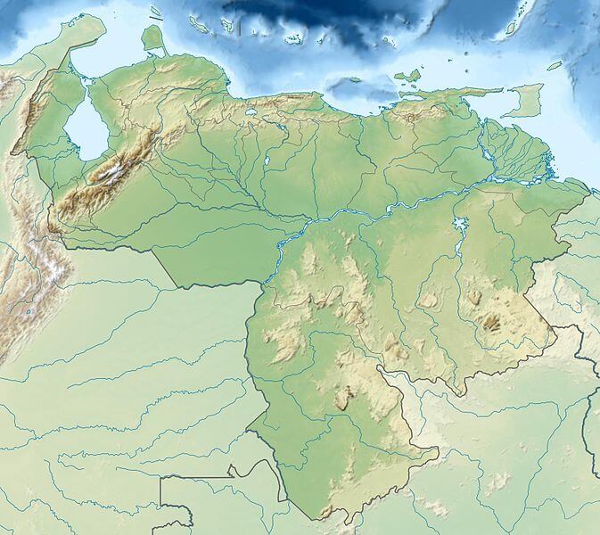
Relief map of Venezuela.
Complete List of Major Venezuelan Peaks
Cordillera de Mérida
- Pico Bolívar - 4,978m (16,332ft)
- Pico Humboldt - 4,940m (16,207ft)
- Pico La Concha - 4,920m (16,142ft)
- Pico El Toro - 4,755m (15,600ft)
- Pico El León - 4,740m (15,551ft)
- Pico Los Nevados - 4,717m (15,476ft)
- Pico Mucuñuque - 4,609m (15,121ft)
Guiana Highlands
- Cerro Marahuaca - 3,840m (12,598ft)
- Cerro Duida - 3,760m (12,336ft)
- Cerro de la Neblina - 3,014m (9,888ft)
- Mount Roraima - 2,810m (9,219ft)
- Auyán-tepui - 2,450m (8,038ft)
Cordillera de la Costa
- Pico Naiguatá - 2,765m (9,072ft)
- Cerro El Ávila - 2,159m (7,083ft)
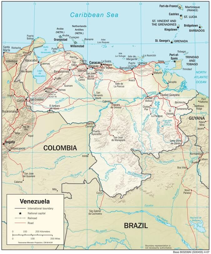
Venezuela physiographic map.