Exploring the Gulf of Venezuela and the Guajira Peninsula
The Gulf of Venezuela and the Guajira Peninsula are strategically important due to their ecological diversity and role in regional trade and natural resource extraction. The Gulf serves as a vital shipping route for petroleum, while the Guajira Peninsula is home to the Indigenous Wayuu and diverse ecosystems.


The Gulf of Venezuela and the Guajira Peninsula: A Shared Landscape of Geopolitical and Ecological Significance
At the northern edge of South America, where the Caribbean Sea meets the continent, lies a region of strategic importance and unique ecological diversity—the Gulf of Venezuela and the Guajira Peninsula. These two interconnected geographical features between Venezuela and Colombia play a crucial role in regional trade, natural resource extraction, and environmental preservation. The Gulf of Venezuela serves as an important shipping route for petroleum. At the same time, the Guajira Peninsula, the northernmost peninsula in South America, is home to the Indigenous Wayuu people and a mosaic of ecosystems ranging from tropical jungles to arid deserts. Yet, beyond its natural beauty, the region has long been the subject of territorial disputes between Colombia and Venezuela, making it not only a place of ecological interest but also of geopolitical complexity.
Geographical Overview of the Gulf of Venezuela
Location and Boundaries
The Gulf of Venezuela, a broad inlet of the Caribbean Sea, lies on the north coast of South America, flanked by Venezuela and Colombia. To the east, it is bordered by Venezuela's Paraguaná Peninsula in Falcón State, and to the west by Colombia's Guajira Peninsula. This positioning places the Gulf at a strategic maritime crossroads, with its waters serving as a crucial route for shipping goods, particularly crude oil, from the rich petroleum-producing region of Lake Maracaibo. A narrow artificial canal connects the Gulf to Lake Maracaibo, allowing vessels to navigate between the two bodies of water, making the Gulf a key player in Venezuela's oil exports.
Economic Importance and Shipping
The Gulf's primary economic role has long been its connection to Lake Maracaibo, which facilitates oil transportation. Lake Maracaibo is one of Venezuela's most important oil-producing areas, and the Gulf's waters form part of the crucial export route for petroleum and related products. However, the region surrounding the Gulf is largely uncultivated and characterized by lowlands with limited agricultural activity.
Despite its importance as a shipping channel, the Gulf of Venezuela has been the subject of a prolonged territorial dispute between Colombia and Venezuela. Both nations have claimed parts of the Gulf, particularly its waters and seabed, which are believed to contain potential oil and gas reserves. Negotiations to resolve the dispute have been ongoing for decades, but a definitive agreement has yet to be reached.
The Guajira Peninsula: A Land of Contrasts
Location and Climate
The Guajira Peninsula, shared by Colombia and Venezuela, stretches into the Caribbean Sea and is the northernmost point of South America. The peninsula, covering an area of approximately 25,000 square kilometers (9,700 square miles), is bordered by the Caribbean to the north and west, the Gulf of Venezuela to the southeast, and the Sierra Nevada de Santa Marta and Sierra de Perijá mountain ranges to the south. This geographical diversity leads to a wide range of climates and ecosystems, making the Guajira Peninsula a region of sharp environmental contrasts.
In the southern part of the peninsula, the proximity to the Sierra Nevada de Santa Marta generates high rainfall levels, resulting in lush, humid jungles with annual precipitation of up to 3,000 millimeters (120 inches). In contrast, the northern and central areas of the peninsula are dominated by arid and semi-arid landscapes, with as little as 300 millimeters (12 inches) of rain annually. These desert-like conditions directly result from the region's exposure to the dry trade winds that blow from the Caribbean, causing a resurgence of nutrient-rich coastal waters along the peninsula's western shores.
The Wayuu People and Land Use
The Guajira Peninsula is home to the Indigenous Wayuu people, who have lived there for centuries. The Wayuu primarily inhabit the arid plains and desert areas, raising cattle, sheep, goats, and horses. Their traditional livelihoods depend on the sustainable use of the land's limited resources, and they have developed a deep understanding of the harsh, dry environment.
In addition to the Wayuu, descendants of Spanish colonists have settled in the southeastern part of the peninsula, particularly in areas with more fertile soils, such as the Padilla Province in Colombia. Here, the land is better suited to agriculture, thanks to the influence of nearby river basins, including the Cesar River. Large-scale plantations of cotton and sorghum have been established in this part of the Guajira, along with cattle ranching, one of the principal economic activities.
Ecological Diversity and the Role of Trade Winds
Xeric Scrub and Coastal Ecosystems
The Guajira Peninsula's climate and geography have created a distinct ecosystem known as the Guajira-Barranquilla xeric scrub. This vegetation type is found along the northeastern coast of Venezuela and the Antilles, where the trade winds from the northern hemisphere create arid conditions. These scrublands are characterized by drought-resistant plants that have adapted to the region's minimal rainfall, providing habitat for a variety of wildlife, including reptiles, birds, and small mammals.
The trade winds also profoundly impact the peninsula's coastal waters. As these winds blow across the Caribbean, they cause upwelling, or the resurgence of deeper, nutrient-rich waters to the surface. This phenomenon makes the western side of the Guajira Peninsula particularly productive regarding marine biodiversity. The nutrient-rich waters attract fish and other marine species, which, in turn, support local fishing communities.
The Ranchería River and Water Resources
The Ranchería River, originating in the northeastern flank of the Sierra Nevada de Santa Marta, is the Guajira Peninsula's only major river. It flows through the southern part of the peninsula, providing a critical water source in an otherwise arid region. The river's headwaters benefit from the high rainfall in the Sierra Nevada, allowing it to sustain agricultural activities and human settlements in its lower reaches.
However, water scarcity remains a significant issue for much of the peninsula, particularly in the northern desert areas. The harsh conditions in this part of the Guajira make it difficult for local communities to access fresh water, and ongoing efforts to manage water resources and address environmental challenges are crucial for the region's sustainability.
Geopolitical Tensions: The Gulf of Venezuela Dispute
For decades, Colombia and Venezuela have engaged in negotiations over the control of the Gulf of Venezuela. The territorial boundaries and potential oil and gas reserves beneath the Gulf's seabed are at stake. The two nations have periodically formed bilateral commissions to resolve the dispute, but no final agreement has been reached. As a result, the Gulf remains a contested maritime zone, with both nations asserting their claims to different sections of its waters.
The strategic importance of the Gulf, both as a shipping route and a potential source of untapped energy, adds complexity to the negotiations. Resolving the dispute would likely require careful diplomacy and cooperation between Colombia and Venezuela and consideration of the region's inhabitants' environmental and economic impacts on the region's inhabitants.
Conclusion
The Gulf of Venezuela and the Guajira Peninsula represent a dynamic and multifaceted region where natural landscapes, indigenous cultures, and geopolitical challenges intersect. The Gulf is an important shipping route for Venezuela's oil industry, while the Guajira Peninsula offers a unique ecological and cultural landscape shaped by trade winds, deserts, and tropical forests. As territorial disputes between Colombia and Venezuela continue, the region's importance as an economic and environmental asset remains clear. The Guajira Peninsula, in particular, exemplifies the resilience of its people and ecosystems, while the Gulf of Venezuela holds potential for energy development and ecological preservation.
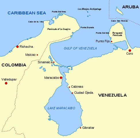
Map showing the Guajira Peninsula, the Gulf of Venezuela and Lake Maracaibo.