Paraguaná and Médanos de Coro: Where Desert Meets the Caribbean
The Paraguaná Peninsula, located between the Caribbean Sea and the Gulf of Venezuela, is rich in natural beauty, history, and economic significance. Connected to the mainland by the Médanos Isthmus, the peninsula is home to Médanos de Coro National Park, a desert landscape of wind-sculpted dunes.


 https://www.flickr.com/photos/fagonar/527020205/")


The Paraguaná Peninsula and Médanos de Coro National Park: A Blend of Desert Landscapes and Coastal Riches
The Paraguaná Peninsula, nestled between the Caribbean Sea and the Gulf of Venezuela, is rich in natural beauty, history, and economic significance. Connected to the mainland by the sandy Médanos Isthmus, the peninsula is home to Médanos de Coro National Park, a unique desert landscape of wind-sculpted dunes and coastal plains. This juxtaposition of desert and sea, combined with the area's historical role as a hub for pirates and smugglers, creates a compelling destination for ecological study and exploration. The region's economic importance in the petroleum industry further enhances its prominence in Venezuela.
Geographic Features of the Paraguaná Peninsula
Location and Boundaries
The Paraguaná Peninsula is the largest in Venezuela, stretching approximately 60 kilometers (40 miles) from north to south and boasting a coastline of about 300 kilometers (200 miles). Located in northwestern Venezuela, the peninsula is bordered by the Caribbean Sea to the north and the Gulf of Venezuela to the east. Often referred to as an island due to its near-complete encirclement by water, Paraguaná is connected to the Venezuelan mainland by the Médanos Isthmus, a 27-kilometer (16.78-mile) stretch of dunes and coastal plains.
Topography and Climate
Its low elevation and arid landscape characterize the Paraguaná Peninsula. The terrain is predominantly flat, with infertile soil that supports sparse vegetation. The region's desert-like conditions are shaped by strong winds and minimal rainfall, creating a harsh environment for plant life. Despite these challenges, the Paraguaná Peninsula has maintained ecological and economic significance, particularly with the establishment of the petroleum industry in the 20th century. The coastal indentations along the peninsula's western side provide ideal locations for oil refineries, which have become a cornerstone of the local economy.
Historical and Economic Importance
Colonial Era
During the colonial period, the Paraguaná Peninsula was a notorious haven for pirates and smugglers, taking advantage of its strategic location along major Caribbean trade routes. Its remote and sparsely populated nature made it an ideal base for illicit activities, contributing to its colorful history.
Petroleum Industry
In modern times, the Paraguaná Peninsula has gained considerable economic importance due to the development of the petroleum industry. Pipelines from the oil-rich fields around Lake Maracaibo run to the Paraguaná refineries, where crude oil is processed for export. The region's proximity to tanker routes in the Caribbean makes it an ideal location for oil infrastructure, with large coastal refineries driving much of the economic activity on the peninsula. This industrial presence has shaped the local economy, making Paraguaná one of Venezuela's key oil-producing regions.
Médanos de Coro National Park: A Desert Wonderland
Overview and History
Médanos de Coro National Park, located at the southern tip of the Paraguaná Peninsula near the city of Coro, was established in 1974 to protect the unique desert ecosystem of the Médanos Isthmus. Covering over 91 square kilometers (35 square miles), the park is known for its expansive dunes, some of which reach heights of up to 40 meters (130 feet). These towering dunes, or Médanos, are constantly reshaped by the powerful winds blowing off the Caribbean Sea. The park is the only extensive area of dunes in South America, making it a geographically distinct and ecologically important region.
Distinct Ecozones
Médanos de Coro National Park is divided into three distinct ecozones, each contributing to the area's biodiversity and ecological significance:
- Alluvial Plain: The alluvial plain is formed by the Mitare River delta and smaller streams, creating a fertile region where sediment is deposited. This plain contrasts sharply with the surrounding desert landscape, offering a plant and animal life refuge.
- Aeolian Plain: The Aeolian Plain consists of three types of dunes, shaped by wind patterns and providing the park's most iconic feature. These dunes form a vast desert landscape that stretches approximately 30 kilometers (18.6 miles) along the Médanos Isthmus, creating a constantly shifting environment of peaks and valleys.
- Coastal Plain: The coastal plain includes mangrove swamps and salt marshes along the park's coastline. These coastal habitats are vital for the preservation of marine life and bird species that rely on the wetlands for nesting and feeding.
Flora and Fauna
Despite the harsh desert conditions, Médanos de Coro National Park supports a range of plant and animal species adapted to survive in this arid environment. The vegetation is sparse, with thorny shrubs dominating the landscape. The park protects part of the Paraguaná xeric scrub ecoregion, which consists of hardy, drought-resistant plants that thrive in the dry climate.
The park is an Important Bird Area (IBA), home to 21 bird species, including the endangered Yellow-shouldered Amazon parrot (Amazona barbadensis). This colorful bird, known for its bright yellow shoulders, relies on the park's xeric scrub habitat for food and nesting. Other animal species are scarce, but the park supports populations of lizards, rabbits, anteaters, and foxes, all of which have adapted to the desert environment.
Médanos Isthmus: The Bridge Between Land and Sea
Geographic Significance
The Médanos Isthmus is crucial in connecting the Paraguaná Peninsula with mainland Venezuela. Measuring approximately 6 kilometers (3.73 miles) wide and 27 kilometers (16.78 miles) long, the isthmus serves as a natural bridge between two very different landscapes: the arid deserts of the peninsula and the more diverse ecosystems of the mainland. The wind-swept dunes of the Médanos Isthmus are constantly changing shape, providing a striking visual contrast to the calm waters of the Caribbean on one side and the Gulf of Venezuela on the other.
Conclusion
The Paraguaná Peninsula and Médanos de Coro National Park offer a fascinating combination of desert landscapes, coastal ecosystems, and historical significance. From its role as a colonial-era refuge for pirates and smugglers to its modern-day importance as a hub for the petroleum industry, Paraguaná holds a unique place in Venezuela's geography and economy. Médanos de Coro National Park, with its towering dunes and distinct ecozones, provides a rare glimpse into the desert habitats of South America. Together, these regions highlight the diversity of Venezuela's natural and cultural heritage, making them significant for their ecological importance and contribution to the country's historical narrative.
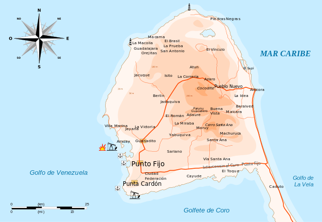
Map illustrating the Paraguaná Peninsula.