Exploring the West Indies: A Geographic and Cultural Overview
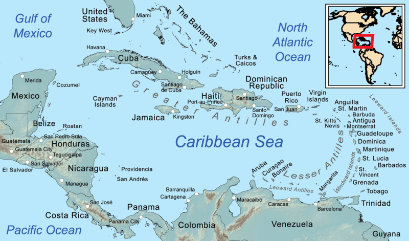
The West Indies, nestled amidst the azure waters of the Atlantic Ocean and the Caribbean Sea, is renowned for its diverse landscapes and rich cultural heritage. Comprising the Lucayan Archipelago and the Antilles, this area encompasses a myriad of islands, each with its unique charm and significance.
Exploring the West Indies: A Geographic and Cultural Overview
The West Indies, cradled between the azure waters of the North Atlantic Ocean and the Caribbean Sea, is a captivating region celebrated for its breathtaking landscapes and vibrant cultural tapestry. Encompassing the Lucayan Archipelago and the Antilles, this area comprises a mosaic of islands, each with unique allure and historical significance.
From the Greater Antilles's colonial charm to the Lesser Antilles' natural splendor and the Lucayan Archipelago's tranquil beauty, the West Indies beckons intrepid travelers and explorers to embark on a journey of discovery. Whether it's wandering through the cobblestone streets of old Havana, exploring the lush rainforests of Dominica, or basking in the pristine beaches of Turks and Caicos, these islands offer a rich tapestry of experiences for those willing to venture off the beaten path.
With their unparalleled beauty, cultural diversity, and rich history, the West Indies stand as a testament to the resilience of their people and the breathtaking wonders of the Caribbean.
Lucayan Archipelago
The Lucayan Archipelago, also known as the Bahama Archipelago, is an island group in the western North Atlantic Ocean, north of Cuba and east of Florida. It comprises the Commonwealth of The Bahamas and the British Overseas Territory of the Turks and Caicos Islands. These islands are renowned for their stunning beaches, crystalline waters, and vibrant marine life. The Lucayan people, the original inhabitants of the Bahamas, have left a lasting cultural legacy on these islands, evident in their art, music, and traditions.
Antilles
The Antilles, an archipelago located in the Caribbean Sea, is divided into two major groups: the Greater Antilles and the Lesser Antilles. These islands boast a rich history and diverse geography, ranging from lush rainforests to towering mountains and volcanic landscapes.
Greater Antilles
The Greater Antilles, comprising Cuba, Hispaniola (Haiti and the Dominican Republic), Puerto Rico, Jamaica, and the Cayman Islands, constitute nearly 90% of the landmass of the entire West Indies. These islands are known for their vibrant culture, historic cities, and bustling ports. Cuba, the largest island in the Caribbean, is famous for its colonial architecture, vibrant music scene, and pristine beaches.
Hispaniola, shared by Haiti and the Dominican Republic, is a land of contrasts, with bustling cities, lush mountains, and vibrant cultural traditions. Puerto Rico, a US territory, is renowned for its rich history, diverse cuisine, and stunning natural beauty. Jamaica, the birthplace of reggae music, is celebrated for its lively culture, beautiful beaches, and lush rainforests. The Cayman Islands, a British Overseas Territory, are known for their crystal-clear waters, world-class diving, and upscale resorts.
Lesser Antilles
The Lesser Antilles, forming a long island arc between the Greater Antilles and South America, is divided into three groups: the Leeward Islands, the Windward Islands, and the Leeward Antilles. These islands offer a wealth of natural beauty, from pristine beaches to rugged mountains and lush rainforests.
Leeward Islands
The Leeward Islands, situated where the northeastern Caribbean Sea meets the western Atlantic Ocean, include the Virgin Islands, Anguilla, Saint Martin, Saint Kitts and Nevis, Antigua and Barbuda, Montserrat, Guadeloupe, and its dependencies. These islands are known for their stunning beaches, vibrant culture, and historic landmarks.
The Virgin Islands, a group of British and US territories, are renowned for their pristine beaches, turquoise waters, and world-class snorkeling and diving. Saint Martin, a unique island shared by France and the Netherlands, offers a blend of European sophistication and Caribbean charm. Guadeloupe, a French Overseas Department, is celebrated for its lush rainforests, stunning waterfalls, and vibrant Creole culture.
Windward Islands
The Windward Islands, located south of the Leeward Islands, include Dominica, Saint Lucia, Saint Vincent and the Grenadines, Grenada, and Barbados. These islands are characterized by their volcanic landscapes, lush rainforests, and vibrant cultural heritage. Dominica, known as the "Nature Island," is celebrated for its pristine rainforests, dramatic waterfalls, and abundant wildlife. Saint Lucia, with its iconic Pitons, pristine beaches, and lush rainforests, is a popular destination for honeymooners and nature lovers. Saint Vincent and the Grenadines, a chain of 32 islands and cays, offer secluded beaches, crystal-clear waters, and charming fishing villages. Grenada, known as the "Spice Isle," is famous for its fragrant spices, lush landscapes, and colorful festivals. Barbados, a former British colony, is renowned for its stunning beaches, vibrant nightlife, and rich cultural heritage.
Leeward Antilles
The Leeward Antilles, located off the coast of Venezuela, include the Dutch ABC islands (Aruba, Bonaire, and Curaçao) and a group of Venezuelan islands. These islands are known for their arid landscapes, stunning coral reefs, and vibrant culture. Aruba, a popular tourist destination, is celebrated for its pristine beaches, vibrant nightlife, and colorful Dutch colonial architecture. Bonaire, a diver's paradise, is renowned for its crystal-clear waters, diverse marine life, and world-class diving and snorkeling. Curaçao, with its colorful capital city of Willemstad, stunning beaches, and vibrant culture, offers a blend of European sophistication and Caribbean charm.
In conclusion, the West Indies is a region of unparalleled beauty, diversity, and cultural richness, waiting to be discovered by intrepid travelers and explorers. From the Greater Antilles's colonial charm to the Lesser Antilles's natural splendor and the Lucayan Archipelago's tranquil beauty, these islands offer a wealth of experiences for those willing to venture off the beaten path. As guardians of their natural environments and stewards of their rich cultural heritage, the West Indies hold the key to unlocking the secrets of the Caribbean, inviting visitors to embark on a journey of exploration, discovery, and adventure.

Map depicting the regions of the Caribbean.
