Anguilla: The Tranquil Jewel of the Caribbean
Nestled in the serene waters of the Caribbean Sea, the British Overseas Territory of Anguilla beckons with its easygoing atmosphere, magnificent beaches, and natural beauty. Anguilla offers a unique blend of rich cultural heritage, pristine landscapes, and a tapestry of tiny islets that add to its allure.
]")
 Shaddick Point, Rendezvous Bay, Cove Bay, and Maundays Bay. by Roy Googin / CC BY (https://creativecommons.org/licenses/by/3.0)")
")
")
, Anguilla - via Wikimedia Commons")

The Tranquil Jewel of the Caribbean: Exploring Anguilla and Its Outlying Islets
Nestled in the serene waters of the Caribbean Sea, the British Overseas Territory of Anguilla beckons visitors with its easygoing atmosphere, magnificent beaches, and untamed natural beauty. As the most northerly of the Leeward Islands in the Lesser Antilles, Anguilla stands as a true gem of the region, offering a unique blend of rich cultural heritage, pristine landscapes, and a tapestry of tiny islets that add to its allure.
Steeped in a rich history that dates back to the indigenous Arawakan-speaking Indians, Anguilla's tranquil shores have long captivated those seeking an escape from the hustle and bustle of the modern world. With its laid-back Caribbean charm and warm, welcoming spirit, this enchanting island nation invites travelers to immerse themselves in a world of endless blue horizons, swaying palms, and sun-drenched beaches stretching as far as the eye can see.
Geographic Location and Overview
Anguilla is strategically positioned directly north of the island of Saint Martin, separated by the narrow Anguilla Channel. The territory, comprising the main island and several smaller islands and cays, boasts a total land area of 91 square kilometers (35 square miles) and a population of approximately 17,400 (2018).
The main island of Anguilla, the largest in the territory, stretches approximately 26 kilometers (16 miles) long and 4.8 kilometers (3 miles) wide at its widest point. This flat and bare island is fringed by pristine white sand beaches, inviting visitors to bask in the warm embrace of the Caribbean sun.
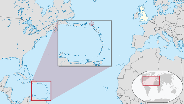
Location map of Anguilla in the Caribbean.
Historical and Cultural Roots
Long before Christopher Columbus arrived in the Caribbean, Anguilla was home to the Arawakan-speaking Indians, who had settled on the island around 2000 BCE and called it Malliouhana. This indigenous population had migrated from the Orinoco River basin of South America, establishing a rich cultural heritage later influenced by European colonization.
In 1650, British settlers from the nearby island of Saint Kitts colonized Anguilla, and the territory has remained a British possession ever since, administered as part of the Leeward Islands colony. Today, most of Anguilla's population is of African descent, with English as the official language and Christianity, predominantly Anglican and Methodist denominations, as the main religions.
Natural Landscapes and Biodiversity
Anguilla's natural landscapes are a testament to the island's geological history and ecological diversity. The main island, formed from coral and limestone, features a relatively flat yet undulating terrain, with Crocus Hill being the highest point at 64 meters (210 feet) above sea level.
The island's tropical climate, characterized by average temperatures in the low 80s °F (around 28 °C) and an annual rainfall of approximately 900 millimeters (35 inches), supports diverse wildlife. Land reptiles, sea turtles, lobsters, and goats thrive in this natural haven, while the island serves as a popular stopover for migratory birds, including the national bird, the turtledove.
Outlying Islands and Islets
Beyond the main island's picturesque shores, Anguilla's true magic lies in its collection of outlying islets, each a miniature paradise unto itself. From the rugged beauty of the uninhabited Anguillita to the vibrant birdlife of Dog Island and the secluded coves of Little Scrub Island, these tiny gems offer a glimpse into the untamed natural wonders that have drawn visitors to the Caribbean for centuries.
Anguillita: A small, uninhabited rocky island off the western tip of Anguilla, Anguillita is a hidden gem for scuba divers and snorkelers. Its rugged coastline offers the opportunity to explore its rugged coastline and encounter marine life, such as barracudas, stingrays, and turtles.
Dog Island: Located approximately 13 kilometers (8 miles) northwest of Anguilla, Dog Island is a low and rocky island with three small cays off its west and north coasts. The island's coastline, characterized by low cliffs alternating with sandy beaches, is a haven for nesting seabirds, particularly sooty terns.
Little Scrub Island: Lying just 1.3 kilometers (0.81 miles) northeast of the main island, Little Scrub Island is home to the unique Little Scrub ground lizard (Ameiva corax) and provides a nesting site for various bird species.
Prickly Pear Cays: A pair of uninhabited islands covered in shrubland, the Prickly Pear Cays are a popular tourist destination offering abundant marine and bird life, as well as two restaurants and a bar serviced by staff from the Anguilla mainland.
Scrub Island: With an area of 8 square kilometers (3.1 square miles), Scrub Island is a privately owned island off the eastern tip of Anguilla. It boasts the remains of an abandoned airfield and no modern utilities. Its status as an Important Bird Area due to its nesting seabirds adds to its natural allure.
Sombrero: Also known as Hat Island, Sombrero is the northernmost island of the Lesser Antilles, lying 54 kilometers (34 miles) northwest of Anguilla. Its rough surface and sparse vegetation belie its significance as an Important Bird Area for breeding seabirds.
Sandy Island: This small island, measuring only about 250 x 75 meters (820 x 246 feet), is home to a local restaurant and offers visitors the opportunity to experience its fine sand and coral beach, as well as the richness of its seabed.
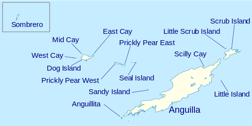
Location map of islands and islets of Anguilla.
Tourism and Attractions
Anguilla's easygoing atmosphere and magnificent beaches and waters have made it a popular tourist destination. The island's main economic activities revolve around tourism and financial services. Visitors are drawn to the island's tranquil ambiance, pristine natural landscapes, and opportunities for outdoor adventures, such as snorkeling, diving, and bird-watching.
The Valley
Serving as Anguilla's capital and administrative center, The Valley is a bustling town located in the heart of the island, facing the picturesque Crocus Bay and the nearby Crocus Hill. While colonial architecture is scarce due to the relocation of the island's administration in the past, The Valley boasts Wallblake House, a heritage plantation house and museum annex dating back to 1787, offering a glimpse into Anguilla's rich history.
Conservation Efforts
Anguilla has taken steps to protect its ecosystems and biodiversity, recognizing the importance of preserving its natural heritage. The Prickly Pear Cays, for instance, were classified as 'wildlands' by the "Eastern Caribbean Natural Area Management Program" (ECNAMP), one of six marine protected areas of Anguilla, safeguarding the islands' abundant marine and bird life.
Conclusion
Anguilla, the tranquil jewel of the Caribbean, captivates visitors with its laid-back charm, pristine beaches, and diverse natural landscapes. From the main island's undulating terrain and rich cultural heritage to the allure of its outlying islets, each offering unique experiences, Anguilla promises an unforgettable journey through the heart of the Caribbean. Whether seeking relaxation, outdoor adventures, or a deep dive into the region's rich history and biodiversity, this British Overseas Territory is a true paradise, inviting travelers to immerse themselves in its embrace.
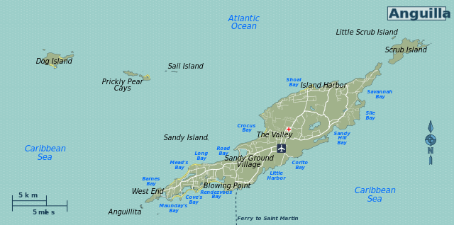
Map of Anguilla showing regions/points of interest.