Exploring the Turks and Caicos: From Coral Reefs to Cultural Heritage
The Turks and Caicos Islands, located in the Lucayan Archipelago of the Atlantic Ocean, are a collection of islands south of the Bahamas and northeast of Cuba. As a British Overseas Territory, this archipelago consists of two main island groups: the larger Caicos Islands and the smaller Turks Islands.
 https://www.flickr.com/photos/bz3rk/5733681282")
 https://www.flickr.com/photos/bz3rk/5733680636/")

")


 https://www.flickr.com/photos/bz3rk/5733678376/in/album-72157626624809749/")
 https://www.flickr.com/photos/bz3rk/5733677336/in/album-72157626624809749/")
")
")
 https://www.flickr.com/photos/bz3rk/5733134043/in/album-72157626624809749/")
Turks and Caicos Islands: An In-Depth Exploration of a Caribbean Gem
The Turks and Caicos Islands, located in the Lucayan Archipelago of the Atlantic Ocean, are a breathtaking collection of islands south of The Bahamas and northeast of Cuba. As a British Overseas Territory, this archipelago consists of two main island groups: the larger Caicos Islands and the smaller Turks Islands. Known for their pristine beaches, rich history, vibrant culture, and diverse ecosystems, the Turks and Caicos Islands have become a popular tourist destination and an important offshore financial center. The Turks and Caicos Islands continue attracting visitors worldwide, with a population of approximately 45,114 (2021).
Geographic and Ecological Overview: Location and Composition
The Turks and Caicos Islands are situated on an underwater plateau marine bank, forming part of the greater Caribbean region. The archipelago comprises eight large cays (keys), numerous smaller cays, and islets, reefs, banks, and rocks. The Turks Islands, including Grand Turk and Salt Cay, are located east, while the Caicos Islands, including Providenciales, North Caicos, Middle Caicos, and South Caicos, lie west. The islands' strategic location places them at the confluence of several oceanic currents, enhancing their biodiversity and ecological significance.
Natural Environment
The islands are formed by coral reefs and are characterized by low-lying terrain, with the highest elevation being 50 meters (163 feet) at Blue Hills on Providenciales. The islands' limestone foundation features numerous karst formations, such as banana holes, caves, caverns, and sea cliffs. Notable examples of these features include "The Hole" on Providenciales and "Conch Bar Caves" on Middle Caicos.
The archipelago experiences limited rainfall, which occurs two to three times a year, often resulting in flooding. This unique climatic condition supports drought-resistant vegetation, including xerophytic shrubs, scrub, savanna, and mangroves. The diverse ecosystems are home to various endemic species, making the islands a critical habitat for breeding seabirds, shorebirds, reptiles, invertebrates, and plants. The marine environment surrounding the islands is equally rich, with coral reefs providing a habitat for spiny lobsters, conchs, snappers, groupers, sharks, and sea turtles.
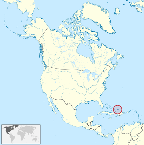
Map depicting the location of the Turks and Caicos Islands.
Historical and Cultural Background
Early Inhabitants and European Contact
The Arawakan-speaking Lucayan Taíno people originally inhabited the Turks and Caicos Islands. The first recorded European sighting of the islands occurred in 1512, leading to significant changes for the Indigenous population. Within a generation, the Lucayan Taíno were largely wiped out due to disease and Spaniard enslavement.
Colonial Era and Salt Industry
In the mid-1600s, Bermudian salt collectors visited the islands seasonally and eventually settled permanently with their enslaved Africans. The salt industry became one of the first major international industries in the Americas. Around the turn of the 18th century, the islands also served as pirate hideouts.
Following the American War of Independence, many Loyalists fled to the British Caribbean colonies, bringing enslaved Africans and developing cotton as a cash crop. However, the salt industry soon became the dominant economic activity. In 1783, the islands were captured by the French but were later confirmed as a British colony by the Treaty of Paris. In 1799, the Turks and Caicos Islands were annexed by Britain as part of the Bahamas and governed indirectly through various territories until they received their own governor in 1973.
Modern Era
The modern era has seen significant foreign investment and commercial land development, particularly in Providenciales, which has propelled the islands' growth. Today, tourism and offshore finance are the primary industries contributing to the islands' economic prosperity. The population remains predominantly of African heritage, and the majority of the population is Christian. Cockburn Town, the seat of government since 1766, is located on Grand Turk Island and serves as the main commercial center.
Economy
Tourism and Offshore Finance
Tourism is the primary industry in the Turks and Caicos Islands, driven by the archipelago's stunning natural beauty, crystal-clear waters, and luxury resorts. Providenciales, or "Provo," is the most developed island and a major tourist destination. It features numerous resort hotels, an 18-hole golf course, and the picturesque Grace Bay. The tourism sector supports various ancillary businesses, including restaurants, water sports, and guided tours, making it a vital part of the local economy.
The islands also serve as an offshore financial center, attracting significant foreign investment and commercial land development. The tourism sector supports various ancillary businesses, including restaurants, water sports, and guided tours, making it a vital part of the local economy.
Agriculture and Fisheries
Agriculture is limited due to the scarcity of arable land, but subsistence crops such as corn, beans, cassava, and fruits are grown primarily on the western Caicos Islands. The islands also have a rich marine ecosystem, supporting a robust fishing industry. Key species include spiny lobsters, conchs, snappers, groupers, sharks, and sea turtles.
Key Islands and Attractions
Turks Islands
Grand Turk Island: The largest and most developed of the Turks Islands, Grand Turk Island is home to the territory's capital, Cockburn Town. The island spans 18 square kilometers (6.9 square miles) and hosts the Grand Turk Cruise Center, a major tourist hub. Notable sites include the historic Grand Turk Lighthouse, erected in 1852, and the JAGS McCartney International Airport. The island's history as a salt industry hub is evident in the numerous salt ponds and historical ruins scattered across the island.
Salt Cay: Salt Cay, the second-largest Turks Island, is known for its rich history in the salt industry. With fewer than 80 inhabitants, the island offers a peaceful retreat with uncrowded beaches and activities such as whale-watching and scuba diving. The island's landscape is marked by salt pans and the ruins of historical salt operations, offering a glimpse into its storied past. Visitors can explore the island's charming Balfour Town, established in 1673, and enjoy the tranquil atmosphere.
Caicos Islands
Providenciales (Provo): Providenciales is the most developed and populated island in the Turks and Caicos, covering 98 square kilometers (38 square miles) with a population of approximately 23,769 (2012). The island is a hub for tourism, offering luxury resorts, golf courses, and natural attractions like Chalk Sound National Park and Northwest Point Marine National Park. With its powdery white sand and turquoise waters, Grace Bay is a popular destination for sunbathing, swimming, and water sports.
North Caicos: North Caicos is the second-largest island in the archipelago and is connected to Middle Caicos by a causeway. It is known for its lush vegetation, abundant rainfall, and the island's largest flock of Pink Flamingos. Key towns include Bottle Creek, Whitby, Kew, and Sandy Point. Visitors can explore the island's natural beauty, including Cottage Pond, a giant sinkhole with brackish water, and Wade's Green Plantation, a historical Loyalist plantation site.
Middle Caicos: Middle Caicos is the largest island in the Turks and Caicos, characterized by green landscapes and significant Lucayan Indian archaeological sites. The island is also home to the largest cave network in the Bahamian Archipelago at Conch Bar. Visitors can explore the island's rich history and natural beauty, including the Indian Cave, which features ancient petroglyphs, and the Mudjin Harbor, known for its stunning limestone cliffs and turquoise waters.
South Caicos: South Caicos, known for excellent fishing and scuba diving, has a rich history as a former salt exporter. The island's primary settlement, Cockburn Harbor, was once the most active commercial community in the Turks and Caicos. Today, South Caicos is a quiet destination with a small, close-knit community. Visitors can explore the island's salt pans, historic ruins, and natural beauty, including the Admiral Cockburn Land and Sea National Park, which offers excellent snorkeling and diving opportunities.
Uninhabited and Privately Owned Islands
The Turks and Caicos Islands include numerous uninhabited and privately owned islands, such as Big Ambergris Cay, Little Ambergris Cay, Bay Cay, Bush Cay, and Dellis Cay. These islands offer pristine natural environments and opportunities for private retreats and eco-tourism. Some notable private islands include Parrot Cay, known for its luxury resort, and Pine Cay, which features an exclusive private club.
Conservation and Environmental Protection
The Turks and Caicos Islands are committed to preserving their unique natural environments through various conservation efforts. Protected areas such as Chalk Sound National Park, Northwest Point Marine National Park, and the wetlands support diverse ecosystems and ensure the survival of endemic species. The islands' coral reefs and marine habitats are important for biodiversity, providing breeding grounds for fish and other marine life.
Conservation initiatives focus on sustainable tourism, protecting marine and terrestrial habitats, and mitigating the impacts of climate change and human activities. The islands' status as a UNESCO World Heritage Site highlights their global significance and the need for continued preservation efforts.
Conclusion
The Turks and Caicos Islands are a Caribbean paradise, offering a rich blend of natural beauty, cultural heritage, and modern amenities. From the vibrant tourism industry to the unique geological features and historical significance, the islands provide a wealth of experiences for visitors and residents alike. As a British Overseas Territory, the Turks and Caicos Islands continue to develop while preserving their unique environment and cultural identity. The archipelago's commitment to conservation and sustainable tourism ensures that its natural and cultural treasures will be protected for future generations.
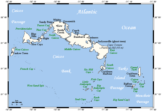
Map of the Turks and Caicos Islands.