Nicaragua's Diverse Aquatic Ecosystems: From Volcanic Craters to Coastal Lagoons
Nicaragua, Central America's largest country, has abundant water resources that have shaped its geography and ecology for millennia. From large freshwater lakes to extensive rivers draining into both oceans, its hydrological features are among the most significant and diverse in the region.

 https://www.flickr.com/photos/adamcohn/9719464459")
 https://www.flickr.com/photos/ana12321/3167312465/")


Nicaragua's Aquatic Treasures: A Geographic and Ecological Survey of Central America's Water-Rich Nation
Nicaragua, the largest country in Central America, possesses an extraordinary abundance of water resources that have shaped its geography, ecology, and human civilization for millennia. From the vast freshwater lakes that dominate the landscape to the extensive river systems that drain into both the Pacific and Atlantic oceans, Nicaragua's hydrological features represent some of the most significant and diverse water bodies in the region. The country's unique position between two oceans, combined with its volcanic terrain and tropical climate, has created a complex network of aquatic ecosystems that support remarkable biodiversity and provide essential resources for the nation's population.
The Great Lakes of Nicaragua
Lake Nicaragua: The Crown Jewel
Lake Nicaragua, locally known as Cocibolca, is the largest freshwater lake in Central America and the 19th largest lake in the world by surface area. Covering approximately 8,264 square kilometers (3,191 square miles), the lake stretches 177 kilometers (110 miles) from northwest to southeast and reaches a maximum width of 58 kilometers (36 miles). With an average depth of 15 meters (49 feet) and a maximum depth of 26 meters (85 feet), Lake Nicaragua contains an estimated 108 cubic kilometers (26 cubic miles) of fresh water.
The lake's formation dates back approximately 20,000 years when volcanic activity created a depression that was subsequently filled by water. What makes Lake Nicaragua particularly remarkable is its unique ecosystem, which includes the world's only freshwater sharks—bull sharks that have adapted to the lake's freshwater environment after being cut off from the ocean. The lake contains over 400 islands, with Ometepe Island being the largest, formed by two volcanic cones rising from the lake's waters.
Lake Managua: The Northern Companion
Lake Managua, also known as Xolotlán, is Nicaragua's second-largest lake, spanning 1,042 square kilometers (402 square miles). Located northwest of Lake Nicaragua, this shallow lake has an average depth of just 9 meters (30 feet) and reaches a maximum depth of 20 meters (66 feet). The lake sits at an elevation of 39 meters (128 feet) above sea level and has historically suffered from significant pollution due to urban runoff and industrial waste from the capital city of Managua, which lies on its southern shore.
Despite environmental challenges, Lake Managua remains ecologically important, supporting a diverse array of fish species and waterfowl populations. The lake is connected to Lake Nicaragua through the Tipitapa River, forming a natural drainage system that ultimately empties into the Caribbean Sea via the San Juan River.
River Systems and Drainage Patterns
Pacific Drainage Basin
The Pacific slope of Nicaragua features numerous short but significant rivers that flow westward from the central highlands to the Pacific Ocean. The Estero Real, which forms part of the border with Honduras, represents the most substantial river system on the Pacific side. These rivers are characterized by their seasonal flow patterns, with dramatic increases during the rainy season from May to October.
The volcanic nature of the Pacific slope creates fertile alluvial plains that support extensive agricultural activities. Rivers such as the Tamarindo, Brito, and Gil González provide crucial irrigation water for crops and support riparian ecosystems that serve as wildlife corridors between highland and coastal habitats.
Atlantic Drainage Basin
The Atlantic drainage basin encompasses the majority of Nicaragua's territory and includes some of Central America's most important river systems. The Coco River, known as the Wanks River in the Miskito language, forms the longest river in Central America, stretching approximately 750 kilometers (466 miles) from its source in the Honduran highlands to its mouth on the Caribbean coast. The river serves as the natural border between Nicaragua and Honduras for much of its length.
The San Juan River system represents Nicaragua's most historically and economically significant waterway. Flowing 192 kilometers (119 miles) from Lake Nicaragua to the Caribbean Sea, the San Juan River has long been envisioned as a potential route for an interoceanic canal. The river's strategic importance has led to numerous international disputes and continues to be a source of tension between Nicaragua and Costa Rica, as it forms part of their shared border.
Other major Atlantic-flowing rivers include the Prinzapolka, Kurinwas, and Escondido rivers, which drain the eastern highlands and support extensive wetland ecosystems in the Caribbean lowlands. These rivers are characterized by their meandering courses through tropical rainforests and their role in sustaining Indigenous communities that depend on fishing and river transportation.
Coastal Waters and Wetlands
Pacific Coast
Nicaragua's Pacific coastline extends approximately 350 kilometers (217 miles) and features a variety of coastal water bodies, including estuaries, lagoons, and tidal flats. The most significant of these is the Gulf of Fonseca, a large Pacific inlet spanning approximately 1,800 square kilometers (700 square miles) and shared among Nicaragua, Honduras, and El Salvador. This sheltered gulf extends inland for approximately 65 kilometers (40 miles) and represents one of Central America's most important transboundary marine ecosystems.
The Estero Padre Ramos, a significant estuarine system near the Honduran border, encompasses approximately 150 square kilometers (58 square miles) of mangrove forests and tidal channels that serve as crucial nursery areas for marine species.
The coastal waters support important fisheries, particularly for shrimp, snapper, and other commercially valuable species. The presence of numerous volcanic islands and rocky outcrops along the coast creates diverse marine habitats that support both artisanal and commercial fishing operations.
Caribbean Coast
The Caribbean coastline stretches approximately 480 kilometers (298 miles) and features extensive wetland systems that rank among the most biodiverse in Central America. The region's coastal waters are influenced by the outflow of major rivers, creating brackish conditions that support unique ecosystems.
The Pearl Lagoon system, covering approximately 550 square kilometers (212 square miles), represents one of the largest coastal lagoon complexes in Central America. Connected to the Caribbean Sea through several channels, Pearl Lagoon supports diverse fish populations and serves as a critical habitat for manatees, crocodiles, and numerous bird species.
Volcanic Lakes and Crater Waters
Nicaragua's volcanic landscape has created numerous crater lakes, which contribute to the country's hydrological diversity. Laguna de Apoyo, formed in a volcanic caldera approximately 23,000 years ago, covers 21 square kilometers (8.1 square miles) and reaches depths of up to 175 meters (574 feet). The lake's pristine waters maintain a constant temperature of approximately 26°C (79°F) and support endemic fish species found nowhere else on earth.
Other notable volcanic lakes include Laguna de Masaya and Laguna de Nejapa, as well as numerous smaller crater lakes scattered throughout the volcanic highlands. These water bodies serve as important sources of fresh water for local communities and support unique ecosystems adapted to the mineral-rich volcanic soils.
Wetland Systems and Biodiversity
Nicaragua's wetland systems encompass approximately 1.2 million hectares (3 million acres) and include diverse habitats ranging from coastal mangroves to inland freshwater marshes. The Indio Maíz Biological Reserve, situated along the San Juan River, safeguards one of the largest remaining tracts of tropical rainforest in Central America and encompasses extensive riverine wetlands that support exceptional biodiversity.
The wetlands serve as critical habitat for numerous species, including the endangered West Indian manatee, American crocodile, and jaguar. These systems also provide essential ecosystem services, including flood control, water filtration, and carbon sequestration, making them vital for both environmental conservation and climate regulation.
Hydroelectric Resources and Water Management
Nicaragua's abundant water resources have significant potential for harnessing hydroelectric power. The country currently operates several hydroelectric facilities, with the largest being the Centroamérica plant on the Tuma River. The mountainous terrain and reliable precipitation patterns in the central highlands provide ideal conditions for additional hydroelectric development.
Water management challenges include balancing hydroelectric development with environmental conservation, managing seasonal variations in precipitation, and addressing water quality issues in urban areas. The government has implemented various water management strategies, including watershed protection programs and sustainable development initiatives in critical water resource areas.
Climate Change and Future Challenges
Climate change poses significant challenges to Nicaragua's water resources, with projected changes in precipitation patterns and increased frequency of extreme weather events. The El Niño and La Niña phenomena already cause substantial variations in rainfall and river flow, affecting both water availability and flood risks.
Rising sea levels threaten coastal wetlands and freshwater aquifers, while changing precipitation patterns may alter the hydrological balance of the great lakes and river systems. Adaptation strategies include improving water storage infrastructure, enhancing flood management systems, and implementing conservation programs to protect critical watersheds.
Conservation and Environmental Protection
Nicaragua has established numerous protected areas to safeguard its water resources and the ecosystems associated with them. The Bosawás Biosphere Reserve, recognized by UNESCO, protects headwaters of several major rivers and encompasses over 2 million hectares (5 million acres) of tropical forest and wetland habitats.
International cooperation plays a crucial role in water resource conservation, particularly for transboundary water bodies such as the San Juan River and the Coco River. Regional agreements and conservation initiatives help ensure sustainable management of shared water resources while protecting biodiversity and ecosystem services.
Summary
Nicaragua's water bodies represent a remarkable hydrological treasure, encompassing vast freshwater lakes, extensive river systems, diverse coastal waters, and unique volcanic crater lakes. The country's position between two oceans, combined with its volcanic terrain and tropical climate, has created an exceptional array of aquatic ecosystems that support extraordinary biodiversity and provide essential resources for human development. From the massive Lake Nicaragua with its unique freshwater sharks to the extensive wetland systems of the Caribbean coast, these water bodies face both opportunities and challenges in the 21st century. Sustainable management of these resources requires striking a balance between hydroelectric development and environmental conservation, addressing the impacts of climate change, and maintaining international cooperation for transboundary water systems. The future of Nicaragua's aquatic treasures depends on continued commitment to conservation, scientific research, and adaptive management strategies that protect these invaluable natural resources for future generations.
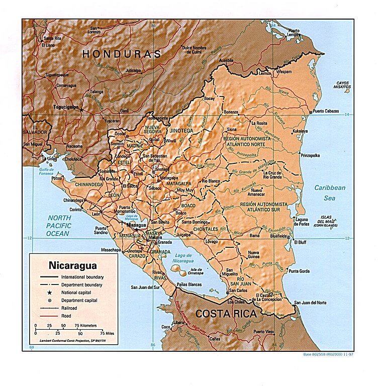
Relief map of Nicaragua.
Notable Water Bodies of Nicaragua
Major Lakes
- Lake Nicaragua (Cocibolca): 8,264 km² (3,191 sq mi), Southwest Nicaragua
- Lake Managua (Xolotlán): 1,042 km² (402 sq mi), Northwest Nicaragua
- Laguna de Apoyo: 21 km² (8.1 sq mi), Masaya Department
- Laguna de Masaya: 5.2 km² (2.0 sq mi), Masaya Department
- Laguna de Nejapa: 2.8 km² (1.1 sq mi), Managua Department
- Laguna de Tiscapa: 0.6 km² (0.2 sq mi), Managua
- Laguna de Asososca: 0.5 km² (0.2 sq mi), Managua Department
Major Rivers
- Coco River (Wanks River): 750 km (466 mi), Northern border with Honduras
- San Juan River: 192 km (119 mi), Southern border with Costa Rica
- Prinzapolka River: 245 km (152 mi), Eastern Nicaragua
- Kurinwas River: 185 km (115 mi), Eastern Nicaragua
- Escondido River: 89 km (55 mi), Central-Eastern Nicaragua
- Estero Real: 137 km (85 mi), Northwestern Nicaragua
- Tipitapa River: 20 km (12 mi), Connects Lakes Managua and Nicaragua
Coastal Lagoons and Estuaries
- Gulf of Fonseca: 1,800 km² (700 sq mi), Pacific coast shared with Honduras and El Salvador
- Pearl Lagoon: 550 km² (212 sq mi), Caribbean coast
- Estero Padre Ramos: 150 km² (58 sq mi), Pacific coast near the Honduras border
- Laguna de Bismuna: 45 km² (17 sq mi), Caribbean coast
- Laguna de Wounta: 35 km² (14 sq mi), Caribbean coast
- Laguna de Karata: 25 km² (9.7 sq mi), Caribbean coast
Islands in Water Bodies
- Ometepe Island: 276 km² (107 sq mi), Lake Nicaragua
- Zapatera Island: 52 km² (20 sq mi), Lake Nicaragua
- Solentiname Archipelago: 43 km² (17 sq mi), Lake Nicaragua
- Momotombo Island: 2.5 km² (1.0 sq mi), Lake Managua
Alternative Titles
- "Liquid Landscapes: Nicaragua's Diverse Aquatic Ecosystems"
- "Between Two Oceans: The Hydrological Wealth of Nicaragua"
- "From Volcanic Craters to Coastal Lagoons: Nicaragua's Water Resources"
- "The Great Lakes Nation: Nicaragua's Freshwater Legacy"
- "Rivers, Lakes, and Wetlands: A Geographic Survey of Nicaragua's Waters"
- "Nicaragua's Blue Heritage: An Exploration of Central America's Water Giant"
- "Freshwater Sanctuary: The Aquatic Geography of Nicaragua"