The Guiana Shield: A Billion-Year Legacy of Stone and Life
The Guiana Shield in northeastern South America is a testament to Earth's deep history. This ancient craton forms the foundational block of the South American Plate, shaping the bedrock and landscapes of Guyana, Suriname, French Guiana, Venezuela, Colombia, and Brazil.


")
 https://www.flickr.com/photos/dallasreeves/15123226305/")

South America's Precambrian Jewel: Geology and Biodiversity of the Guiana Shield
Draped across the northeastern corner of South America, the Guiana Shield stands as a profound testament to the Earth's deep history, a geological and ecological symphony played out over eons. Forged in the fiery depths of the Precambrian eon, dating back an astonishing 1.7 billion years, this ancient geological formation forms a stable craton, a foundational block of the South American Plate, shaping the very bedrock and landscapes of Guyana, Suriname, French Guiana, Venezuela, Colombia, and Brazil. Far beyond its remarkable geological antiquity, the Guiana Shield is a globally significant haven for biodiversity, a vibrant tapestry of life with the awe-inspiring Guiana Highlands serving as its dramatic and ecologically rich crown jewel.
Guiana Shield: A Billion Years in the Making - Geological Tapestry and Foundation for Life
The Guiana Shield unfolds as a breathtaking geological masterpiece, revealing a rich and intricate collage of ancient rock formations that have steadfastly endured the relentless forces of weathering and tectonic activity for an incredible 1.7 billion years. Primarily composed of metamorphic rocks, the shield showcases complex and often beautifully layered metasediments, ancient greenstone belts that hint at early volcanic activity, and vast expanses of sub-horizontal formations, including resilient sandstones, hard quartzites, fine-grained shales, and cemented conglomerates. These formations are not merely inert rocks; they represent a tangible chronicle of Earth's primordial history, offering invaluable insights into the dynamic geological processes that shaped this venerable shield over countless millennia.
The ancient canvas of the Guiana Shield is further enriched by later intrusions of younger mafic rocks, such as gabbros, which inject a layer of geological dynamism and complexity into its overall makeup, often associated with mineral deposits. These geological nuances, the interplay of ancient and more recent formations, have profoundly influenced the topography, soil development, and ultimately, the distribution of water across the shield. This geological foundation, sculpted over vast timescales, has set the stage for the remarkable biological flourishing that has made the Guiana Shield home to the world's largest expanse of relatively undisturbed tropical forest on any Precambrian shield, creating a unique and invaluable landscape that intricately weaves together the threads of ancient Earth processes and the vibrant life that now thrives upon it.
Biodiversity Marvels: A Sanctuary of Endemism and Ecological Importance
The Guiana Shield is far more than a geological relic; it is a globally significant biodiversity haven, a sanctuary for life unparalleled in its richness, endemism, and ecological importance. This ancient landmass harbors an astonishing array of species, estimated to include over 3,000 vertebrate species alone, representing a treasure trove of unique and often highly localized life forms. In its pristine freshwater ecosystems, endemic fish species, often exhibiting remarkable adaptations to the specific conditions of individual river systems and waterfalls, navigate the clear waters. The lush and largely intact forests provide critical habitat for a dazzling diversity of amphibians, reptiles, birds, and mammals, many of which are found nowhere else on Earth. This exceptional biodiversity extends far beyond mere species counts; it is a living testament to the shield's long history of relative isolation and the complex ecological interactions that have evolved over millions of years.
Recognizing its global ecological significance, the Guiana Shield has become a vital hub for ecological research and conservation efforts. It attracts scientists and conservationists from around the world to study and protect the delicate balance of species that inhabit this ancient landmass. The shield serves as a crucial living laboratory, where each rare or abundant species plays a vital role in the intricate web of life that defines its remarkable ecological marvels. This highlights the urgent need for continued conservation and sustainable management of this irreplaceable natural heritage.
Distinctive Upland Areas: Sculpting the Shield's Topography and Ecology
Within the vast expanse of the Guiana Shield, three distinctive upland areas rise, contributing significantly to its topographical diversity and creating unique ecological niches, each adding its own distinct dimension to the shield's overall grandeur:
Guiana Highlands: Tepuis, Waterfalls, and Endemic Life
Stretching across Venezuela, Guyana, and Brazil, the Guiana Highlands unfold as an extensive, mostly forested plateau and low-mountain region, characterized by dramatic escarpments and deep valleys. The landscape is most famously dominated by the iconic tepuis, table-like mountains with sheer vertical cliffs and often flat, isolated summits that rise majestically from the surrounding forests. These ancient sandstone formations, remnants of a once continuous plateau, shape the visual identity of the highlands and serve as isolated "sky islands," hosting unique and often highly endemic flora and fauna that have evolved in isolation for millions of years, adapted to the challenging environments of their nutrient-poor and often cloud-shrouded summits. The highlands are punctuated by breathtaking and some of the world's highest waterfalls, including the awe-inspiring Angel Falls in Venezuela and the powerful Kaieteur Falls in Guyana, which cascade dramatically from the tepuis, adding a profound sense of grandeur to the already enchanting landscape.
Tumucumaque Uplands: A Gentle Transition
Spanning a broad arc across Suriname, Guyana, and Brazil, the Tumucumaque Uplands comprise a series of central massifs, generally lower in elevation than the Guiana Highlands, that slope gently towards the vast Amazon River Basin to the south and the Atlantic Ocean to the north and east. This region significantly contributes to the shield's topographical diversity, providing a crucial transitional zone between the elevated highlands and the lower-lying expanses of the surrounding lowlands. The gentle slopes and diverse ecosystems, encompassing a mix of forests and savannas, make this area ecologically essential to the Guiana Shield's overall geographical and biological mosaic, facilitating species dispersal and maintaining hydrological connectivity.
Chiribiquete Plateau: Sandstone Outlier and Archaeological Significance
Situated at the western edge of the Guiana Shield, primarily within Colombia, the Chiribiquete Plateau is a distinct sandstone-topped marvel, reaching elevations of up to 900 meters (approximately 2,950 feet). This plateau, distinct in its geological composition from the predominantly metamorphic rocks of the eastern shield, forms a significant biogeographical boundary between the Guiana Shield and the eastern Andes Mountains. Separated by the thick Neogene sediments of the Sub-Andean Trough, the Chiribiquete Plateau stands as a testament to the shield's intricate geological boundaries and its complex interactions with the surrounding geological provinces. Beyond its geological uniqueness, the Chiribiquete Plateau is also renowned for its exceptional biodiversity and its remarkable archaeological significance, containing thousands of ancient rock paintings that provide invaluable insights into the early human occupation of this remote and fascinating region.
Summary
The Guiana Shield, a vast and ancient geological formation in northeastern South America, represents a remarkable confluence of deep time and vibrant life. Formed 1.7 billion years ago, its Precambrian bedrock underpins a landscape of exceptional biodiversity, harboring thousands of species, many of which are endemic. The shield's topography is further diversified by distinctive upland regions, including the dramatic tepuis and waterfalls of the Guiana Highlands, the transitional Tumucumaque Uplands, and the unique sandstone Chiribiquete Plateau. This ancient craton, with its rich geological history and unparalleled ecological significance, underscores the Guiana Shield's vital role as a global reservoir of biodiversity and a crucial area for ongoing scientific research and conservation efforts, ensuring the preservation of its timeless terrain and the thriving life it supports for future generations.
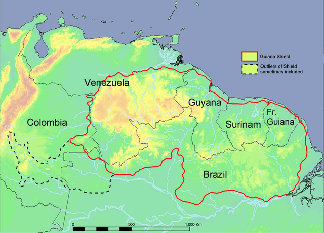
Political map of the Guiana Shield.