Costa Rica's Hydrographic Treasures: From Mountain Streams to Coastal Waters
Costa Rica, renowned for its biodiversity, boasts a vast network of water bodies that are vital to its ecosystems and communities. Its location between two oceans, mountainous terrain, and frequent rainfall fosters diverse habitats, ranging from mountain streams to wetlands.
 https://www.flickr.com/photos/31267353@N03/42043225555")


Nature's Corridors: The Vital Water Bodies of Costa Rica's Tropical Paradise
Costa Rica, a small Central American nation renowned for its extraordinary biodiversity and environmental stewardship, possesses a remarkable network of water bodies that serve as the lifeblood of its ecosystems and communities. Despite comprising only 0.03% of the world's landmass, this tropical paradise hosts an intricate system of rivers, lakes, wetlands, and coastal waters that support nearly 4% of the planet's biodiversity. The country's unique position between two oceans, combined with its mountainous topography and abundant rainfall, creates diverse aquatic environments that range from pristine mountain streams to vast wetland complexes.
The water bodies of Costa Rica tell a story of geographical diversity, ecological abundance, and human ingenuity in sustainable resource management. From the windswept waters of Lake Arenal, which generate clean electricity, to the seasonal wetlands of Caño Negro, which support migratory wildlife, these aquatic systems demonstrate the intimate connection between water resources and environmental conservation. Understanding Costa Rica's water bodies offers insight into how a small nation can achieve remarkable success in balancing economic development with environmental protection, serving as a global model for sustainable water management.
Geographic Foundation and Drainage Patterns
Costa Rica's water systems are fundamentally shaped by the country's dramatic topography and strategic location between the Pacific Ocean and the Caribbean Sea. The nation's mountainous backbone, formed by the Cordillera Central and other volcanic ranges, creates a natural watershed divide that determines the flow patterns of rivers and streams across the landscape.
The country's river systems are organized into three distinct drainage areas, reflecting the underlying geographical structure. The northern drainage area encompasses rivers that flow toward the San Juan River and ultimately into the Caribbean Sea. The Caribbean drainage encompasses rivers flowing directly eastward to the Caribbean coast. The Pacific drainage includes all rivers flowing westward to the Pacific Ocean, creating the most extensive watershed system in the country.
This topographical arrangement results in relatively short but steep rivers that descend rapidly from the mountains to the coastal plains. The combination of steep gradients, abundant rainfall, and volcanic soils creates dynamic river systems that support diverse ecosystems while providing essential services, including hydroelectric power generation, irrigation, and transportation.
Lake Arenal: The Crown Jewel of Renewable Energy
Lake Arenal stands as Costa Rica's largest lake and perhaps its most significant contribution to sustainable energy development. Located in the northern region beneath the imposing Arenal Volcano, this impressive water body demonstrates how human engineering can enhance natural systems while providing essential resources for national development.
Originally a natural lake formed by ancient volcanic activity, Lake Arenal was dramatically transformed in 1979 when the construction of the Presa Sangregado Dam expanded its size threefold. The expanded lake now covers 85 km² (33 sq mi) with depths varying seasonally between 30 and 60 m (98 and 197 ft). The engineering project created not only Costa Rica's largest lake but also established one of Central America's most important renewable energy facilities.
The lake's significance extends far beyond its impressive dimensions. The Arenal Hydroelectric Project harnesses the consistent water flow to generate approximately 70% of Costa Rica's electricity, making it a cornerstone of the country's commitment to renewable energy. The project exemplifies Costa Rica's innovative approach to sustainable development, demonstrating how large-scale infrastructure can support both economic growth and environmental goals.
Ecological and Economic Impact
The creation of the enlarged Lake Arenal required significant environmental and social adjustments, including the relocation of entire communities and the flooding of agricultural lands. However, the long-term benefits have proven substantial, providing clean energy that reduces dependence on fossil fuels while supporting the country's impressive environmental record. The lake now supports recreational activities, including windsurfing and sport fishing, which contribute to the region's growing ecotourism industry.
The consistent winds across Lake Arenal's surface have also made it an ideal location for wind power generation, with several wind farms established around the lake's perimeter. This combination of hydroelectric and wind power demonstrates Costa Rica's comprehensive approach to renewable energy development.
Volcanic Lakes and Crater Systems
Costa Rica's volcanic landscape has created numerous crater lakes that represent some of the country's most unique and scientifically important aquatic environments. These high-altitude lakes, formed in dormant or extinct volcanic craters, offer valuable insights into geological processes while supporting specialized ecosystems that are adapted to their unique chemical and physical conditions.
Lake Hule, located south of San Miguel in a dormant volcanic crater, exemplifies these remarkable formations. The lake's isolated position and volcanic origins create distinctive water chemistry that supports endemic species and provides researchers with opportunities to study evolution in isolated aquatic environments. The clear, deep waters reflect the surrounding forest canopy, creating some of Costa Rica's most pristine natural landscapes.
Chemical Diversity and Scientific Value
The volcanic lakes of Costa Rica exhibit remarkable chemical diversity, with varying pH levels, mineral content, and thermal characteristics depending on their geological origins and current volcanic activity. Some crater lakes maintain direct connections to underlying geothermal systems, creating warm-water environments that support unique biological communities. Others remain isolated and cool, developing distinct chemical signatures that reflect their specific geological settings.
Research conducted on these volcanic lakes has made significant contributions to understanding aquatic ecosystem dynamics, volcanic processes, and the evolution of endemic species. The lakes serve as natural laboratories where scientists can study ecosystem development, chemical cycling, and the impacts of geological processes on aquatic life.
River Systems: Arteries of Biodiversity
Costa Rica's river systems represent the country's most extensive and ecologically significant water bodies, creating corridors that support extraordinary biodiversity while providing essential services to human communities. The nation's rivers originate in the mountainous interior and flow through diverse ecosystems, including cloud forests, rainforests, and coastal wetlands, before reaching the ocean.
The Reventazón River system exemplifies the importance of Costa Rica's major rivers, flowing eastward from the central mountains to the Caribbean Sea. The river supports multiple hydroelectric projects while maintaining ecological connectivity between highland and lowland ecosystems. Its tributaries drain extensive areas of protected forests, carrying nutrient-rich waters that support downstream wetlands and coastal ecosystems.
The Tempisque River, which flows through the northwestern Guanacaste Province, illustrates the vital role that rivers play in supporting agricultural communities and wildlife populations. The river's seasonal flooding patterns create extensive wetlands that serve as critical habitat for waterfowl and other wildlife while providing water for irrigation during the dry season.
The Sarapiquí: A River of Life
The Sarapiquí River, which flows through the northern lowlands en route to the Caribbean, is one of Costa Rica's most biologically diverse river systems. The river winds through extensive protected areas, including Braulio Carrillo National Park, supporting populations of endangered species while providing transportation and economic opportunities for local communities.
The Sarapiquí's clear waters support diverse fish populations that form the foundation of complex aquatic food webs. The river's forested banks provide habitat for countless species, including jaguars, tapirs, and over 400 bird species. The system highlights the crucial importance of maintaining forest cover along river corridors to conserve both aquatic and terrestrial biodiversity.
Wetland Complexes: Seasonal Sanctuaries
Costa Rica's wetland systems are among the most productive and biologically important ecosystems in Central America. These seasonal and permanent wetlands serve as critical habitat for resident and migratory wildlife while providing essential ecosystem services, including flood control, water purification, and carbon sequestration.
The Caño Negro Wildlife Refuge, centered around the seasonal Lake Caño Negro, exemplifies the importance of Costa Rica's wetland systems. Located near the northern border with Nicaragua, this vast wetland complex expands and contracts in response to seasonal rainfall patterns, creating dynamic habitat conditions that support an extraordinary diversity of wildlife.
During the wet season, the Caño Negro system transforms into a vast shallow lake covering thousands of hectares. The flooded grasslands and forests provide critical habitat for waterfowl, wading birds, and countless other species. As waters recede during the dry season, concentrated pools support large populations of fish, caimans, and water birds while providing crucial dry-season habitat for terrestrial species.
Migratory Bird Corridors
Costa Rica's wetlands serve as essential stopover and wintering sites for millions of migratory birds traveling between North and South America. The country's position along the Central American flyway makes its wetlands critically important for maintaining continental bird populations. Species including wood storks, jabiru storks, and numerous waterfowl depend on Costa Rica's wetlands for survival during their annual migrations.
The wetlands also support significant populations of resident tropical species, creating remarkable concentrations of wildlife that attract researchers and ecotourists from around the world. The economic value of wildlife viewing in Costa Rica's wetlands contributes substantially to local economies while providing incentives for conservation.
Coastal Waters and Marine Environments
Costa Rica's extensive coastlines along both the Pacific Ocean and the Caribbean Sea create diverse marine environments that support the country's rich biodiversity and important economic activities. The country's territorial waters encompass coral reefs, rocky shores, sandy beaches, and estuarine systems, which provide habitat for numerous marine species.
The Pacific coast features dramatic seasonal changes driven by upwelling currents that bring nutrient-rich waters to the surface. These conditions support productive marine ecosystems, including important fishing grounds and coral reef systems. The Golfo Dulce, a deep tropical fjord on the southern Pacific coast, represents one of only four such formations in the world and supports exceptional marine biodiversity.
The Caribbean coast presents different conditions, with coral reef systems that support high levels of endemism and serve as important nursery areas for commercially important fish species. The protected areas along both coasts, including Manuel Antonio National Park and Cahuita National Park, demonstrate Costa Rica's commitment to marine conservation while supporting sustainable tourism development.
Artificial Water Bodies and Reservoirs
Beyond natural lakes and rivers, Costa Rica has created several artificial water bodies that serve important functions in energy production, water supply, and flood control. These reservoirs exemplify the country's innovative approach to water resource management, while also highlighting the challenges of balancing development needs with environmental protection.
Lake Cachí, formed by damming the Reventazón River, represents another significant hydroelectric reservoir that contributes to Costa Rica's renewable energy portfolio. The lake's creation required careful environmental planning to minimize impacts on forest ecosystems while maximizing the potential for energy generation. The reservoir now supports recreational activities and serves as a habitat for various wildlife species that have adapted to the new aquatic environment.
The success of Costa Rica's reservoir projects reflects comprehensive planning processes that consider environmental, social, and economic factors. These projects demonstrate how developing nations can pursue sustainable development strategies that support economic growth while maintaining environmental quality.
Environmental Challenges and Conservation
Costa Rica's water bodies face numerous environmental challenges that require ongoing attention and innovative management approaches. Climate change impacts precipitation patterns and water availability, while the expansion of agricultural and urban development puts pressure on aquatic ecosystems. Despite these challenges, Costa Rica has implemented comprehensive conservation strategies that serve as models for other nations.
Climate Change Impacts
Rising temperatures and changing precipitation patterns affect water availability and ecosystem dynamics throughout Costa Rica. Decreased rainfall during dry seasons strains water supplies for both human use and ecosystem maintenance. The increased intensity of wet season storms creates flooding risks and potentially affects water quality in rivers and lakes.
The country's high-altitude ecosystems, including cloud forests and alpine lakes, are particularly vulnerable to climate change. Rising temperatures may alter the elevation zones where these ecosystems can persist, potentially affecting water sources and the species that depend on them.
Agricultural and Urban Pressures
Expanding pineapple and banana plantations place increasing demands on water resources while creating potential sources of agricultural pollution. Urban development around major population centers affects water quality and increases demand for reliable water supplies. Costa Rica addresses these challenges through strict environmental regulations and innovative approaches to sustainable agriculture.
The country's payment for ecosystem services program provides economic incentives for landowners to maintain forest cover and protect water sources. These programs demonstrate how market-based mechanisms can support conservation while delivering economic benefits to local communities.
Sustainable Water Management
Costa Rica's approach to water management reflects the country's broader commitment to environmental sustainability and social equity. The nation has implemented comprehensive water resource management strategies that balance competing demands while protecting ecosystem integrity and ensuring equitable access to clean water.
Integrated Watershed Management
Costa Rica employs integrated watershed management approaches that consider entire river basins rather than individual water bodies in isolation. These strategies recognize the interconnected nature of aquatic systems and the importance of maintaining ecosystem connectivity from headwaters to coastal areas.
Watershed management plans incorporate scientific research, community participation, and adaptive management strategies that can respond to changing conditions. The success of these approaches demonstrates the importance of collaborative governance in addressing complex environmental challenges.
Renewable Energy Leadership
The country's commitment to renewable energy generation through hydroelectric and wind power demonstrates how water resources can support sustainable development goals. Costa Rica routinely generates over 99% of its electricity from renewable sources, with hydroelectric power from facilities like Lake Arenal playing a central role in this achievement.
The renewable energy sector provides economic benefits while reducing greenhouse gas emissions and supporting the country's international environmental leadership. Costa Rica's success in renewable energy development offers valuable lessons for other nations seeking to reduce dependence on fossil fuels.
Economic Importance and Ecotourism
Costa Rica's water bodies contribute significantly to the national economy through hydroelectric power generation, sustainable tourism, and ecosystem services. The country's reputation for environmental stewardship attracts millions of visitors annually, many of whom come specifically to experience the diverse aquatic ecosystems and the wildlife they support.
Ecotourism and Recreation
Water-based ecotourism activities, including white-water rafting, sport fishing, and wildlife viewing, generate substantial economic benefits for local communities while providing incentives for conservation. The Pacuare River, renowned for its world-class rafting opportunities, demonstrates how outdoor recreation can support both conservation and economic development.
Lake Arenal attracts windsurfers and sport fishing enthusiasts from around the world, contributing to regional economic development while showcasing the multiple benefits of sustainable water management. These activities provide employment opportunities in rural areas while generating revenue that supports conservation efforts.
Ecosystem Services
Costa Rica's water bodies provide essential ecosystem services, including water purification, flood control, and climate regulation. While difficult to precisely quantify, the economic value of these services represents a significant contribution to national well-being and economic stability.
Wetland systems provide natural flood control, protecting downstream communities and infrastructure. Forest watersheds ensure reliable water supplies for urban areas while maintaining the water quality that supports both human health and ecosystem integrity.
Future Challenges and Opportunities
Costa Rica's water management faces evolving challenges that require innovative approaches and continued commitment to sustainable development principles. Population growth, economic development, and climate change create new pressures on water resources while technological advances offer new opportunities for improved management.
Technological Innovation
Advanced monitoring systems, remote sensing technologies, and enhanced water treatment methods provide opportunities to improve water resource management while minimizing environmental impacts. Costa Rica's investment in education and research provides the foundation for developing and implementing these technological solutions.
The country's leadership in renewable energy positions it well to capitalize on emerging technologies, including enhanced hydroelectric systems and advanced water storage methods. These technologies can enhance energy security while maintaining environmental quality.
Regional Cooperation
Costa Rica's water bodies connect to broader regional systems that require international cooperation for effective management. The San Juan River system, shared with Nicaragua, demonstrates both the challenges and opportunities of transboundary water management. Collaborative approaches can enhance conservation effectiveness while promoting regional stability and development.
Summary
Costa Rica's water bodies represent a remarkable collection of aquatic environments that reflect the country's geographical diversity, ecological richness, and commitment to sustainable development. From the renewable energy generated by Lake Arenal to the biodiversity corridors created by river systems, these water resources demonstrate the multiple benefits of integrated environmental management.
The country's success in balancing development needs with environmental protection provides valuable lessons for water resource management worldwide. The combination of strong environmental policies, innovative financing mechanisms, and community participation has enabled Costa Rica to maintain high-quality aquatic ecosystems while supporting economic growth and social development.
The volcanic lakes, seasonal wetlands, and pristine rivers of Costa Rica serve as living laboratories for understanding ecosystem dynamics and developing conservation strategies. The country's investment in research and education ensures that scientific knowledge continues to inform management decisions, while building capacity to address future challenges.
Costa Rica's water bodies support extraordinary biodiversity that provides both intrinsic value and significant economic benefits through ecotourism and ecosystem services. The protection and sustainable management of these resources remain central to the country's identity as a global leader in environmental stewardship.
As Costa Rica continues to face evolving challenges, including climate change and increasing development pressure, the lessons learned from managing its diverse water bodies will prove invaluable. The country's experience demonstrates that small nations can achieve remarkable environmental success through innovative policies, community engagement, and sustained commitment to sustainability principles.
The water bodies of Costa Rica represent more than geographical features; they embody the country's vision of sustainable development that harmonizes human needs with environmental protection. These aquatic treasures continue to inspire conservation efforts worldwide while supporting the communities and ecosystems that depend on their continued health and vitality.
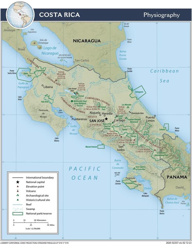
Costa Rica physiographic map.
Notable Water Bodies of Costa Rica
Lakes and Reservoirs
Lake Arenal (Lago Arenal)
- Size: 85 km² (33 sq mi)
- Location: Guanacaste Province, northern Costa Rica
- Maximum depth: 60 m (197 ft) seasonal
- Type: Artificial lake (expanded natural lake)
- Elevation: 543 m (1,781 ft)
Lake Cachí (Lago Cachí)
- Size: 12 km² (4.6 sq mi)
- Location: Cartago Province, eastern end of the Reventazón River
- Type: Artificial reservoir
- Purpose: Hydroelectric power generation
Lake Hule (Laguna Hule)
- Size: 0.5 km² (0.19 sq mi)
- Location: Alajuela Province, south of San Miguel
- Type: Natural crater lake
- Depth: 22 m (72 ft)
Lake Caño Negro (Laguna Caño Negro)
- Size: Variable (up to 800 hectares/1,977 acres during wet season)
- Location: Alajuela Province, near the Nicaragua border
- Type: Seasonal lake
- Fed by: Frío River
Lake Botos (Laguna Botos)
- Size: 0.1 km² (0.04 sq mi)
- Location: Poás Volcano crater, Alajuela Province
- Type: Crater lake
- Elevation: 2,600 m (8,530 ft)
Laguna Barva
- Size: 0.05 km² (0.02 sq mi)
- Location: Barva Volcano crater, Heredia Province
- Type: Crater lake
- Elevation: 2,906 m (9,534 ft)
Major Rivers
San Juan River (Río San Juan)
- Length: 200 km (124 mi) along the Costa Rica border
- Location: Northern border with Nicaragua
- Basin: Caribbean drainage
- Notes: Longest river system affecting Costa Rica
Reventazón River (Río Reventazón)
- Length: 145 km (90 mi)
- Location: Central Costa Rica to the Caribbean Sea
- Basin: Caribbean drainage
- Features: Multiple hydroelectric projects
Tempisque River (Río Tempisque)
- Length: 144 km (89 mi)
- Location: Guanacaste Province
- Basin: Pacific drainage
- Features: Seasonal flooding, wetland formation
Sarapiquí River (Río Sarapiquí)
- Length: 135 km (84 mi)
- Location: Northern Costa Rica
- Basin: Caribbean drainage via San Juan River
- Features: Flows through protected rainforest areas
Pacuare River (Río Pacuare)
- Length: 108 km (67 mi)
- Location: Central Costa Rica to the Caribbean Sea
- Basin: Caribbean drainage
- Features: World-renowned white-water rafting
Tárcoles River (Río Tárcoles)
- Length: 111 km (69 mi)
- Location: Central to the Pacific coast
- Basin: Pacific drainage
- Features: Flows past the San José metropolitan area
Grande de Térraba River (Río Grande de Térraba)
- Length: 160 km (99 mi)
- Location: Southern Costa Rica
- Basin: Pacific drainage
- Features: The Largest Pacific drainage river
Sixaola River (Río Sixaola)
- Length: 76 km (47 mi)
- Location: Caribbean coast, border with Panama
- Basin: Caribbean drainage
- Features: Forms part of the international border
Bebedero River (Río Bebedero)
- Length: 80 km (50 mi)
- Location: Guanacaste Province
- Basin: Pacific drainage
- Features: Tributary of the Tempisque River
Frío River (Río Frío)
- Length: 70 km (43 mi)
- Location: Northern Costa Rica
- Basin: Caribbean drainage via San Juan River
- Features: Feeds Caño Negro wetlands
Wetland Systems
Caño Negro Wildlife Refuge
- Size: 9,969 hectares (24,626 acres)
- Location: Alajuela Province, northern Costa Rica
- Type: Seasonal wetland complex
- Features: Critical migratory bird habitat
Palo Verde National Park Wetlands
- Size: 45,492 hectares (112,426 acres) total park area
- Location: Guanacaste Province
- Type: Seasonal wetlands and dry forest
- Features: Important waterfowl habitat
Térraba-Sierpe Wetlands
- Size: 30,654 hectares (75,745 acres)
- Location: Southern Pacific coast
- Type: Mangrove and freshwater wetlands
- Features: The Largest mangrove system in Costa Rica
Tortuguero Wetlands
- Size: Variable, extensive coastal wetlands
- Location: Caribbean coast, Limón Province
- Type: Coastal lagoons and canals
- Features: Sea turtle nesting beaches, canal systems
Coastal Water Bodies
Golfo Dulce
- Size: 750 km² (290 sq mi)
- Location: Southern Pacific coast
- Type: Tropical fjord
- Depth: Up to 215 m (705 ft)
Golfo de Nicoya
- Size: 1,550 km² (600 sq mi)
- Location: Central Pacific coast
- Type: Large bay/gulf
- Features: Important fishing grounds, islands
Tortuguero Lagoon
- Size: Variable, connected canal system
- Location: Caribbean coast
- Type: Coastal lagoon system
- Features: Wildlife corridor, boat transportation
Crater Lakes (Additional)
Laguna Congreso
- Location: Rincón de la Vieja Volcano
- Type: Crater lake
- Features: Thermal activity
Laguna Jilgueros
- Location: Rincón de la Vieja Volcano
- Type: Crater lake
- Features: Seasonal variations
Laguna Danta
- Location: Tapantí National Park
- Type: Small mountain lake
- Elevation: 2,000 m (6,562 ft)
Laguna Gamboa
- Location: Chirripó National Park area
- Type: High-altitude lake
- Elevation: 3,000+ m (9,843+ ft)