Honduras and Its Diverse Water Bodies: The Liquid Arteries of Central America
Honduras, situated in the heart of Central America, boasts a remarkable tapestry of aquatic landscapes that define both its geography and socioeconomic character, spanning from the Caribbean Sea's turquoise expanse in the north to the Pacific Ocean's protected waters in the south.

, https://www.flickr.com/photos/bz3rk/4739795830")


 coast of Honduras - by P. Jesson Collins, CC BY 4.0, via Wikimedia Commons")
Waterways of Honduras: From Caribbean Shores to Mountain Lakes
Honduras, situated in the heart of Central America, boasts a remarkable tapestry of aquatic landscapes that define both its geography and socioeconomic character. Spanning from the Caribbean Sea's turquoise expanse in the north to the Pacific Ocean's protected waters in the south, from mountain-fed rivers cascading through cloud forests to pristine lakes reflecting volcanic peaks, the nation's water bodies serve as vital lifelines supporting millions of inhabitants, diverse ecosystems, and economic activities. These liquid arteries weave through dramatically varied topographies, creating corridors of life that sustain agriculture, industry, fisheries, and biodiversity across the country's 112,492 km² (43,433 sq mi) territory.
Coastal Waters and Maritime Boundaries
Honduras boasts an extensive coastline stretching 820 km (509 mi) along two major bodies of water. The northern coast extends along the Caribbean Sea, featuring a long and relatively even shoreline that runs eastward from the Gulf of Honduras before curving southward toward the Nicaraguan border at Cape Gracias a Dios. The Caribbean coast encompasses numerous bays, lagoons, and coastal wetlands that provide critical habitat for marine life and support fishing communities.
The Pacific coast presents a stark contrast, measuring significantly shorter and more irregular in configuration. Located entirely within the sheltered waters of the Gulf of Fonseca, Honduras shares this strategic waterway with El Salvador and Nicaragua. The Gulf of Fonseca serves as an important commercial and fishing zone, with its protected waters supporting both artisanal and commercial fishing operations.
Caribbean Coastal Features
The Caribbean coastline features several significant lagoons and coastal water bodies. Caratasca Lagoon, situated in the northeastern region, is one of the country's most important coastal wetlands. The region's numerous coastal lagoons form a complex network of brackish water environments that support diverse ecosystems and serve as nursery grounds for marine species.
These coastal waters support vibrant marine ecosystems, including coral reefs, seagrass beds, and mangrove forests. The Bay Islands, including Roatán, Utila, and Guanaja, are surrounded by some of the Caribbean's most pristine coral reef systems, contributing to Honduras's reputation as a premier diving destination.
The River Systems: Veins of the Nation
Honduras's river network represents a complex hydrological system that drains the country's mountainous interior toward both the Caribbean Sea and the Pacific Ocean. The Atlantic-draining watersheds account for 87% of the country's surface water runoff, highlighting the dominance of Caribbean-bound waterways in the nation's hydrology.
Major Caribbean-Draining Rivers
The Ulúa River, the country's longest waterway, flows 400 km (250 mi) through the economically significant Valle de Sula, serving as a crucial artery for agriculture and industry. The Ulúa River basin supports extensive banana plantations, sugar cane cultivation, and industrial activities, making it one of Honduras's most economically significant watersheds.
The Patuca River, measuring 523 km (325 mi) in length, winds through dense rainforests in the country's eastern regions. This river supports rich biodiversity and Indigenous communities, serving as a transportation corridor and resource base for remote settlements. The Patuca River system drains vast areas of pristine forest, carrying sediments and nutrients from the interior mountains to the Caribbean Sea.
Other significant Caribbean-draining rivers include the Aguán, Sico, and Coco rivers. The Coco River forms part of the international boundary with Nicaragua, creating a shared watershed that requires bilateral management. These rivers collectively support diverse ecosystems, from cloud forests in their headwaters to coastal wetlands at their mouths.
Pacific-Draining Waterways
While smaller in scale compared to Caribbean-draining systems, Pacific-slope rivers play a crucial role in regional water supply and ecosystem function. These waterways drain the southern highlands and empty into the Gulf of Fonseca, supporting agricultural activities and coastal communities along the Pacific coast.
The shorter length and steeper gradients of Pacific-draining rivers result in faster-flowing waters that carry significant sediment loads during rainy seasons. These characteristics create unique ecological conditions, presenting both opportunities and challenges for effective water resource management.
Lake Yojoa: Honduras's Aquatic Jewel
Lake Yojoa (Lago de Yojoa) stands as the only large natural lake in Honduras, representing a unique freshwater ecosystem of national significance. Located 184 km (114 mi) north of the capital, Tegucigalpa, the lake covers 79 km² (49 sq mi), making it a substantial freshwater body in a region where large lakes are scarce.
Physical Characteristics and Setting
Surrounded by massive mountains, Lake Yojoa sits at an altitude of approximately 669 m (2,200 ft) above sea level. The lake measures 22 km in length and 14 km at its widest point, creating a substantial freshwater habitat that supports diverse aquatic life and provides water resources for the surrounding communities.
The lake's high-altitude location and mountain setting create a unique microclimate that influences local weather patterns and supports distinct ecological communities. The surrounding mountains contribute to the lake's water balance through seasonal rainfall and year-round springs, while also protecting the watershed from external disturbances.
Drainage and Hydrology
The Tepemechín River drains the lake on the south, and the Blanco River empties the lake on the north, creating a natural flow-through system that maintains water quality and prevents stagnation. These outlet rivers connect Lake Yojoa to the broader Caribbean-draining watershed, ultimately carrying its waters to the sea through the Ulúa River system.
The lake's hydrology depends on seasonal rainfall patterns, groundwater inputs, and surface runoff from the surrounding mountains. Climate variability and human activities in the watershed influence water levels and quality, making the lake sensitive to environmental changes.
Ecological and Economic Importance
Lake Yojoa supports significant biodiversity, including endemic fish species, migratory birds, and aquatic plants. The lake serves as a crucial stopover point for migratory waterfowl and supports year-round populations of resident bird species. Commercial and recreational fishing activities provide economic benefits to local communities, while the lake's scenic beauty attracts tourists and supports hospitality businesses.
Agricultural activities in the surrounding watershed include coffee cultivation on mountain slopes and cattle ranching in lowland areas. These land uses influence water quality and ecosystem health, creating management challenges that require balancing economic development with environmental protection.
Regional Water Resources and Management
Honduras's water resources face increasing pressures from population growth, urbanization, agricultural expansion, and climate change. The country's abundant rainfall during the wet seasons contrasts with dry season water scarcity in many regions during the dry seasons, creating seasonal management challenges.
Water Quality and Conservation
Industrial activities, agricultural runoff, and urban development threaten water quality in major river systems and Lake Yojoa. Mining operations, particularly in watersheds that drain into the Caribbean, raise concerns about heavy metal contamination and sediment pollution. Deforestation in headwater regions increases erosion rates and reduces watershed stability.
Conservation efforts focus on protecting the remaining forest cover, establishing riparian buffers, and implementing sustainable land-use practices. International cooperation with neighboring countries addresses transboundary water management issues, particularly along shared river systems.
Climate Change Impacts
Climate change projections indicate altered precipitation patterns, an increased frequency of extreme weather events, and rising temperatures that will impact Honduras's water resources. Sea level rise threatens coastal lagoons and low-lying areas, while changing rainfall patterns may alter river flows and lake levels.
Adaptation strategies include improving water storage capacity, developing drought-resistant agricultural practices, and protecting watershed forests that regulate water flows. Early warning systems and disaster preparedness plans address flood risks during extreme precipitation events.
Economic and Social Dimensions
Water bodies throughout Honduras support a diverse range of economic activities that provide livelihoods for millions of people. Fishing industries operate in coastal waters, rivers, and Lake Yojoa, supplying protein sources and export commodities. Agricultural irrigation systems depend on river water for crop production, particularly in the fertile valleys of major river systems.
Transportation and Commerce
Rivers historically served as transportation corridors, facilitating trade and communication between interior regions and coastal ports. While modern road networks have reduced reliance on river transport, waterways continue to support local commerce and provide access to remote communities.
Hydroelectric power generation utilizes the country's abundant water resources, contributing to energy security and economic development. However, dam construction and river modifications create environmental impacts that require careful management.
Tourism and Recreation
Honduras's diverse water bodies attract international tourists seeking adventure sports, wildlife viewing, and cultural experiences. The Bay Islands' coral reefs support a thriving dive tourism industry, while Lake Yojoa attracts birdwatchers and nature enthusiasts. River rafting and fishing expeditions offer additional tourism opportunities, generating foreign exchange and supporting local economies.
Coastal tourism development along both the Caribbean and Pacific shores creates economic opportunities, but also raises concerns about environmental impacts and resource sustainability. Balancing tourism growth with environmental protection remains a key challenge for long-term development.
Summary
Honduras's water bodies represent fundamental components of the nation's geography, ecology, and economy. From the extensive Caribbean coastline with its lagoons and bays to the shorter Pacific shore within the Gulf of Fonseca, coastal waters provide marine resources and support diverse ecosystems. The country's river systems, dominated by Caribbean-draining watersheds like the Ulúa and Patuca rivers, carry the majority of surface water runoff while supporting agricultural, industrial, and transportation needs. Lake Yojoa, as the nation's only major natural lake, serves as a unique freshwater ecosystem that supports biodiversity and provides resources for surrounding communities. These water resources face mounting pressures from development, climate change, and population growth, requiring integrated management approaches that balance economic needs with environmental protection. The continued health and sustainability of Honduras's water bodies remain critical for the nation's future prosperity, ecological integrity, and social well-being.
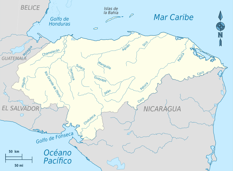
Hydrographic map of Honduras.
Significant Water Bodies of Honduras
Major Lake
Lake Yojoa (Lago de Yojoa)
- Area: 79 km² (49 sq mi)
- Dimensions: 22 km long × 14 km wide at the widest point
- Elevation: 669 m (2,200 ft) above sea level
- Location: West-central Honduras, between Cortés and Comayagua departments
- Drainage: Tepemechín River (south), Blanco River (north)
- Note: Honduras's only large natural lake
Major Rivers (Caribbean-Draining)
Ulúa River
- Length: 400 km (250 mi)
- Basin: Flows through Valle de Sula
- Location: Originates near Lake Yojoa, flows north to the Caribbean Sea
- Note: Economically most important river
Patuca River
- Length: 523 km (325 mi)
- Basin Area: 23,900 km² (9,200 sq mi)
- Location: Eastern Honduras, flows northeast through rainforests
- Note: Drains through the Mesoamerican Biological Corridor
Coco River (Río Coco)
- Length: The Longest river in Central America
- Location: Forms part of the Honduras-Nicaragua border
- Note: Locally known as Wanki River
Aguán River
- Location: Northern Honduras, flows to the Caribbean Sea
- Note: Important for agricultural valleys
Sico River
- Location: Northern Honduras, Caribbean drainage
- Note: Drains the interior highlands
Chamelecón River
- Length: 200 km (124 mi)
- Location: Northern Honduras, Caribbean drainage
- Note: Important regional waterway
Tinto River (Negro River)
- Length: 215 km (134 mi)
- Location: Northern Honduras, Caribbean drainage
- Note: Also known as Río Negro
Plátano River
- Length: 100 km (62 mi)
- Location: Eastern Honduras, flows through the Plátano Biosphere Reserve
- Note: UNESCO World Heritage area waterway
Guayape River
- Location: Central Honduras, tributary of the Patuca River
- Note: Flows through mining regions
Major Rivers (Pacific-Draining)
Choluteca River
- Length: 349 km (217 mi)
- Basin Area: 7,681 km² (2,966 sq mi)
- Location: Flows through Tegucigalpa, empties into the Gulf of Fonseca
- Note: Affected by Hurricane Mitch in 1998
Goascorán River
- Location: Forms part of the Honduras-El Salvador border
- Drainage: Flows to the Gulf of Fonseca
- Note: International boundary river
Lempa River
- Length: 422 km (262 mi) total, 31.4 km (19.5 mi) in Honduras
- Location: Flows through the Ocotepeque Department
- Note: Transboundary river shared with Guatemala and El Salvador
Nacaome River
- Location: Southern Honduras, flows to the Gulf of Fonseca
- Note: Pacific drainage system
Major Lagoons
Caratasca Lagoon
- Area: 1,110 km² (430 sq mi)
- Dimensions: 66 km long × 14 km wide
- Location: Gracias a Dios Department, northeastern Honduras
- Features: Two sea entrances (Tabacunta and Barra de Caratasca)
- Depth: 4 m (13 ft) at Barra de Caratasca entrance
- Tributaries: Mocorón, Warunta, and Nakunta rivers
- Note: The Largest island is Tansin
Brus Lagoon
- Location: West of Caratasca Lagoon, Gracias a Dios Department
- Note: Part of the northeastern coastal lagoon system
Laguna de Los Micos (Laguna Quemada)
- Area: 41.71 km² (16.1 sq mi)
- Basin Area: 389.37 km² (150.3 sq mi)
- Location: West of Tela, Atlántida Department
- Features: Located within Jeannette Kawas National Park
- Note: One of Honduras's largest lagoons
Laguna de Alvarado
- Area: 8.4 km² (3.2 sq mi)
- Depth: Average 4.5 m (15 ft), maximum 6 m (20 ft)
- Location: Caribbean coast
- Note: Important marine habitat
Laguna Tinta
- Location: Between coastal points on the Caribbean coast
- Note: Coastal brackish water lagoon
Coastal Waters
Caribbean Sea
- Coastline Length: Approximately 644 km (400 mi)
- Features: Bay Islands (Roatán, Utila, Guanaja), coral reefs
- Location: Northern coast from the Gulf of Honduras to Cape Gracias a Dios
Gulf of Fonseca (Pacific)
- Coastline Length: Approximately 176 km (109 mi)
- Location: Southern Honduras, shared with El Salvador and Nicaragua
- Features: Protected waters, fishing grounds
Bay Islands
Roatán
- Location: Caribbean Sea, the largest of the Bay Islands
- Features: Coral reef systems, diving destinations
Utila
- Location: Caribbean Sea, Bay Islands
- Features: Marine protected areas
Guanaja
- Location: Caribbean Sea, Bay Islands
- Features: Pristine coral reefs
Other Notable Water Bodies
Trujillo Bay
- Location: Caribbean coast, near Trujillo
- Note: Historic bay, important for marine life and tourism
Swan Islands (Cajones Cays)
- Location: 177 km (110 mi) northeast of Patuca Point
- Note: Small Caribbean islands under Honduran control
Various Coastal Lagoons
- Location: Along the Caribbean coast, particularly in the northeast
- Note: Complex network of brackish water environments
Additional Rivers
Mocorón River
- Location: Eastern Honduras, tributary to the Caratasca Lagoon
- Note: Part of the Caratasca watershed system
Warunta River
- Location: Eastern Honduras, flows to the Caratasca Lagoon
- Note: A Major tributary of the lagoon system
Nakunta River
- Location: Eastern Honduras, flows to the Caratasca Lagoon
- Note: Part of the northeastern watershed
Cangrejal River
- Location: Northern Honduras, near La Ceiba
- Note: Popular for whitewater rafting
Tela River
- Location: Northern Honduras, flows through Tela
- Note: Important for local water supply