Suriname's Aquatic Heritage and Natural Wealth: Rivers of Gold
Nestled in the northeast corner of South America, Suriname is a country deeply connected to its waterways. From the vast rivers that define its borders to the clean reservoirs powering its industries, the country's aquatic environment tells a story of natural wealth, cultural importance, and economic value.

, https://www.flickr.com/photos/-jvl-/33408890481/in/album-72157714724476982/")


 on the Suriname side, on the other side is French Guiana - JuliasTravels, CC BY-SA 3.0, via Wikimedia Commons")

The Aquatic Arteries of Suriname: A Comprehensive Exploration of South America's Hydrographic Treasure
Nestled in the northeast corner of South America, Suriname stands as a nation intimately connected to its waterways. From the expansive rivers that define its international boundaries to the pristine reservoirs that power its industries, the country's aquatic landscape tells a story of natural abundance, cultural significance, and economic importance. The water bodies of Suriname represent far more than mere geographical features; they constitute the lifeblood of a nation where rivers serve as highways, wetlands nurture biodiversity, and artificial lakes generate prosperity.
The Major River Systems
Suriname's hydrological framework centers on seven principal rivers that flow northward toward the Atlantic Ocean, creating a network of waterways that drain the entire country. The most significant of these are the border-defining rivers: the Marowijne in the east and the Corantijn in the west, which, together with their tributaries, drain approximately 58% of the nation's territory.
The Marowijne River: Eastern Boundary and Cultural Corridor
The Marowijne River, known locally as the Maroni, stretches approximately 724 km (450 mi) and serves as the natural boundary between Suriname and French Guiana. For much of its 450-mile (725-kilometre) length, the river divides French Guiana on the east from Suriname on the west. The river's upper course is called the Litani in Suriname, while its middle section, famous for placer gold mining activities, bears the name Lawa. The Marowijne's significance extends beyond geography, as it has historically served as a crucial transportation route and cultural bridge between communities on both sides of the international border. Like the Corantijn, the Marowijne creates a wide estuarine mouth approximately 10 km (6.2 mi) in width, featuring numerous islands and complex tidal dynamics.
The Corantijn River: Western Guardian and Economic Lifeline
The river is quite important in the region, spanning a length of 450 miles and crossing the border between Suriname and Guyana. The Corantijn River forms Suriname's western boundary with Guyana and represents one of the country's most vital waterways. The largest rivers in Suriname are the Corantijn and the Marowijne. Numerous islands are located in both rivers, and the width is approximately 10 km at the mouth. The river's mouth, characterized by its impressive 10 km (6.2 mi) width, forms a substantial estuary that supports a diverse array of marine and terrestrial ecosystems. This wide estuarine mouth forms a significant mixing zone where freshwater and seawater meet, creating complex transitional habitats.
Central Rivers: The Suriname, Coppename, and Saramacca
The central region of Suriname is home to three significant rivers that collectively drain approximately 24% of the country's territory. The Suriname River is the country's most prominent and longest river, stretching approximately 480 km (298 mi). It originates in the Guiana Highlands of southern Suriname and flows northward through the country's central part. The Suriname River holds particular importance as it flows directly past the capital city of Paramaribo, making it central to the nation's political and economic activities. The river empties into the Atlantic Ocean just north of Paramaribo, creating a significant estuary system that includes the Braamspunt mudcape at its mouth. This estuarine formation has been shaped by westward-migrating mudbanks and exhibits changing magnitude and volume over time due to the combined effects of marine and anthropogenic influences.
The Coppename River meanders through the Central Suriname Nature Reserve, a protected area spanning 15,600 km² (6,000 mi²) that showcases the country's exceptional biodiversity. This reserve and the river are home to the Giant River Otter, the largest member of the weasel family, which serves as an indicator species for the health of aquatic ecosystems.
The Saramacca River, while smaller than its counterparts, plays a crucial role in the regional water system and supports numerous communities along its banks. Together with the Suriname and Coppename rivers, it forms an interconnected network that facilitates transportation and commerce throughout the central regions.
Lesser Rivers and Coastal Waterways
The smallest rivers are the Nickerie, Saramacca, and Commewijne rivers, which drain 16% of the country. These rivers, though smaller in scale, maintain significant regional importance. The Nickerie River, positioned as the westernmost major river in Suriname, creates an ecologically significant estuary at its mouth. Tides influence the estuary area and serve as a vital transportation route for maritime activities.
The Commewijne River, flowing through the northern coastal region, connects inland communities to the Atlantic and supports both traditional fishing activities and modern agricultural operations along its fertile banks.
Artificial Water Bodies and Reservoirs
Suriname's water landscape includes significant artificial creations that serve both economic and environmental purposes. The man-made lake, the Prof. Dr. Ir. Van Blommenstein reservoir, is the largest artificial open freshwater resource in Suriname. It is located in the Suriname River at Afobaka, 194 km (121 mi) upriver. It covers an area of 1,560 km² (602 mi²). This massive reservoir, created by damming the Suriname River, serves as the primary source of hydroelectric power for the country's aluminum industry and provides electricity to much of the nation.
Lake Brokopondo: Engineering Marvel and Environmental Impact
Lake Brokopondo, also known as the Van Blommenstein reservoir, is one of the largest artificial lakes in South America. Covering 1,560 km² (602 mi²), it was created in the 1960s as part of a comprehensive development project. The lake not only generates electricity but also supports fishing activities and has become an important habitat for various aquatic species. However, its creation has also resulted in the displacement of Indigenous communities and the flooding of pristine rainforest areas.
Wetlands and Swamp Systems
Suriname's coastal and interior regions feature extensive wetland systems that play a crucial role in water regulation and biodiversity conservation. The total area of the Coronie swamp is about 70,000 ha. The area of the Coesewijne swamp depends on its water level. During the rainy season, it may extend over 800-900 km2. These wetlands serve as natural water storage systems, helping to regulate flooding during the rainy season and maintaining water availability during drier periods.
Seasonal Dynamics and Water Management
The seasonal variation in wetland extent demonstrates the dynamic nature of Suriname's water systems. During the rainy season, typically from May to August, these wetlands expand dramatically, with some swamps nearly doubling in size. This natural rhythm supports diverse ecosystems and provides crucial breeding grounds for numerous species of fish, birds, and other wildlife.
Estuaries and Coastal Ecosystems
Suriname's coastal zone features several critical estuaries where its major rivers meet the Atlantic Ocean. These estuarine systems serve as vital ecological transition zones and represent some of the country's most important environmental assets. The estuaries are characterized by complex dynamics involving freshwater discharge, tidal influences, and marine processes that create unique habitats supporting diverse species assemblages.
The most prominent estuarine system is located along the Suriname River, which forms a substantial estuary north of Paramaribo. The Braamspunt mudcape at the river mouth demonstrates the dynamic nature of these coastal formations, with westward-migrating mudbanks continuously reshaping the landscape. This area serves as a critical nesting habitat for endangered leatherback and green sea turtles, though coastal erosion increasingly threatens these important reproductive sites.
The Corantijn and Marowijne river estuaries, each approximately 10 km (6.2 mi) wide at their mouths, create extensive mixing zones where freshwater and seawater meet. These broad estuarine mouths contain numerous islands and support complex tidal systems that facilitate diverse marine and terrestrial ecosystems. The transitional nature of these environments provides essential nursery habitats for many fish species and supports both resident and migratory bird populations.
These estuarine systems are further supported by extensive mangrove forests and coastal wetlands that provide critical habitats for migratory bird species, fish, and crustaceans. Mangrove ecosystems act as natural barriers against coastal erosion and storm surges, while also serving as important carbon sequestration sites. The interaction between freshwater input and tidal influences creates nutrient-rich environments that support high levels of biological productivity.
Ecological Significance and Biodiversity
The water bodies of Suriname support extraordinary biodiversity, serving as corridors for species movement and providing habitats for both endemic and migratory species. The country's rivers and wetlands are home to numerous species of fish, including commercially important varieties and rare species found nowhere else in the world. The Giant River Otter, jaguars, and countless bird species depend on these aquatic ecosystems for survival.
The estuarine and coastal ecosystems provide critical habitats for migratory birds and marine life, reinforcing the country's ecological significance on a continental scale. These transition zones between freshwater and marine environments support species that depend on both aquatic systems during different life stages, creating biological corridors of international importance.
Economic and Cultural Importance
Beyond their ecological value, Suriname's water bodies serve as economic lifelines for the nation. The rivers provide transportation routes that connect remote interior communities to coastal markets and urban centers. Traditional fishing supports thousands of families, while the hydroelectric power generated from the Suriname River drives industrial development.
The cultural significance of these waterways cannot be overstated. Indigenous communities have depended on these rivers for millennia, developing sophisticated knowledge systems about water management and aquatic resources. The rivers serve as cultural highways, connecting communities and facilitating the exchange of traditions, languages, and customs.
Summary
The water bodies of Suriname represent a complex and vital network that shapes every aspect of the nation's existence. From the massive border rivers that define international boundaries to the intricate wetland systems that regulate water flow, these aquatic features create a landscape of remarkable diversity and importance. The seven major rivers, led by the Marowijne and Corantijn, drain the entire country and provide essential services, including transportation, power generation, and ecosystem support. The Van Blommenstein reservoir serves as a testament to human engineering capabilities while also demonstrating the potential for both development and environmental impact. The seasonal wetlands and swamp systems showcase nature's ability to adapt and thrive in changing conditions, supporting biodiversity that rivals any region in the world. As Suriname continues to develop, the careful management and protection of these water resources will remain crucial for maintaining the delicate balance between human needs and environmental preservation. The aquatic arteries of Suriname continue to flow as they have for millennia, carrying with them the hopes, traditions, and future prosperity of a nation intimately connected to its waters.
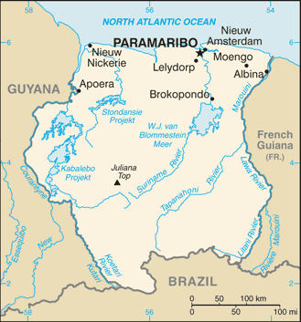
CIA Map of Suriname.
Notable Water Bodies of Suriname
Major Rivers
- Marowijne River - Length: 724 km (450 mi); Location: The eastern border with French Guiana
- Corantijn River - Length: 724 km (450 mi); Location: The western border with Guyana
- Suriname River - Length: 480 km (298 mi); Location: Central Suriname, flows through Paramaribo
- Coppename River - Length: ~200 km (124 mi); Location: West-central Suriname through Central Suriname Nature Reserve
- Saramacca River - Length: ~150 km (93 mi); Location: Central-western Suriname
- Nickerie River - Length: ~100 km (62 mi); Location: Northwestern Suriname near Guyana border
- Commewijne River - Length: ~80 km (50 mi); Location: Northern coastal region
Artificial Water Bodies
- Van Blommenstein Reservoir (Lake Brokopondo) - Area: 1,560 km² (602 mi²); Location: Suriname River at Afobaka, 194 km (121 mi) upriver from Paramaribo
Wetlands and Swamps
- Coronie Swamp - Area: 70,000 ha (173,000 acres); Location: Northwestern coastal region
- Coesewijne Swamp - Area: Variable 800-900 km² (309-347 mi²) during the rainy season; Location: Northern coastal region
Major Estuaries
- Suriname River Estuary - Location: North of Paramaribo; Features: Braamspunt mudcape, sea turtle nesting grounds
- Corantijn River Estuary - Width: 10 km (6.2 mi) at the mouth; Location: The western border with Guyana
- Marowijne River Estuary - Width: 10 km (6.2 mi) at the mouth; Location: The eastern border with French Guiana
Coastal Features
- Braamspunt Mudcape - Location: Suriname River mouth; Significance: Dynamic coastal formation, turtle nesting habitat
- Mangrove Forests - Location: Coastal estuaries; Function: Coastal protection, biodiversity habitat
Tributaries and Secondary Rivers
- Tapanahoni River - Major tributary of Marowijne River; Location: Eastern interior
- Lawa River - Middle course of Marowijne River; Location: Eastern border region
- Litani River - Upper course of Marowijne River; Location: Eastern interior
- Lucie River - Tributary system; Location: Eastern region
- Kabalebo River - Location: Western interior near Corantijn basin