Exploring the Essequibo: Guyana's Mighty Watercourse
The Essequibo River is a mighty river in South America that flows through the heart of Guyana, leaving an unforgettable impression on the country's landscapes, biodiversity, and history. This impressive waterway is the most extensive in Guyana, showcasing its natural beauty and cultural significance.


 https://www.flickr.com/photos/78123065@N00/82132417")

Exploring the Essequibo: Guyana's Mighty Watercourse
The Essequibo River, a titan among South American rivers, gracefully meanders through the heart of Guyana, leaving an indelible mark on the nation's landscapes, biodiversity, and history. This majestic watercourse, the longest and most comprehensive in Guyana, is a testament to the country's natural splendor and cultural significance.
Geographic Origins and Course
The source of the Essequibo River lies in the Acarai Mountains, an enchanting region of wet, forested highlands located in the southern part of Guyana, along the country's border with Brazil. From its mountainous origins, the river embarks on an extraordinary journey, flowing northward through the varied terrain of eastern Guyana, covering an impressive distance of approximately 1,000 kilometers (620 miles). Finally, with unwavering determination, the Essequibo reaches the Atlantic Ocean, making its grand exit just 21 kilometers (13 miles) west of the Guyanese capital, Georgetown.
Ecoregion and Breathtaking Landscapes
As the Essequibo gracefully winds through Guyana, it traverses the Guianan moist forests ecoregion, a vast expanse of relatively pristine lowland tropical rainforests. This ecoregion, marked by its extensive and continuous tracts of untouched natural beauty, contributes significantly to global biodiversity.
Encompassing more than half of Guyana, the Essequibo's basin is a complex network of waterways, intricately woven by tributaries such as the Rupununi, Potaro, Mazaruni, Siparuni, Kiyuwini, Konawaruk, and Cuyuni rivers. These tributaries, each with its unique character, further enrich the Essequibo's course, creating a spectacle of rapids and waterfalls that punctuate the journey. Notable among these natural wonders are Murrays Fall, Pot Falls, Kumaka Falls, and Waraputa Falls, each adding its distinct charm to the river's narrative.
A Mosaic of Islands: Estuarine Diversity
As the Essequibo gracefully approaches the Atlantic Ocean, its estuary unfolds into a breathtaking mosaic of islands. Throughout 32 kilometers (20 miles), the river's channel is adorned with predominantly flat and fertile islands, including Leguan, Wakenaam, and Hogg.
Leguan, spanning about 28 square kilometers (11 square miles); Wakenaam, covering approximately 44 square kilometers (17 square miles); and Hogg, a generous expanse of about 60 square kilometers (23 square miles), form an archipelago of natural splendor. Fort Island, situated off the eastern side of Hogg Island, bears historical significance as the country's government seat during the Dutch colonial era, adding cultural richness to the river's surroundings.
Hub of Commerce and Cultural Significance
Bartica, a bustling town along the Essequibo, emerges as a commerce and cultural exchange hub. Its strategic location facilitates the movement of valuable resources, including gold, diamonds, and timber. Bartica, therefore, plays a crucial role in Guyana's economy, connecting the hinterlands to the broader national and international trade networks.
A Haven for Biodiversity
The Essequibo River is much more than a geographical feature. It is a vibrant ecosystem teeming with diverse flora and fauna. More than 300 fish species have been documented in the Essequibo basin, with almost 60 species being endemic to this unique habitat. It's important to note that this figure may only scratch the surface, as some parts of the basin remain inadequately explored and understood.
In addition to its rich fish fauna, the Essequibo provides a habitat for various terrestrial and aquatic species. Bats, including the pig-faced, fishing, and velvety house bat, represent the native terrestrial mammals. The presence of monkey species such as Geoffroy's spider monkey, mantled howler, and white-headed capuchin adds to the biological diversity. Additionally, the sandy beach along the river's mouth serves as a critical nesting habitat for the endangered leatherback sea turtle (Dermochelys coriacea), underscoring the importance of conservation efforts in the region.
Preserving a National Treasure
The Essequibo River symbolizes Guyana's abundant natural resources with its grandeur and ecological significance. The river has not merely influenced the nation's physical and cultural terrain but, acknowledging its pivotal role, has also emerged as a central focus for conservation efforts.
As part of the Guianan moist forests ecoregion and the larger Guianas region, the Essequibo River represents a biodiversity sanctuary, beckoning explorers, scientists, and nature enthusiasts to unravel its mysteries and contribute to its enduring preservation. Navigating the waters of the Essequibo, one doesn't merely witness a river; one embarks on a journey through the soul of a nation.
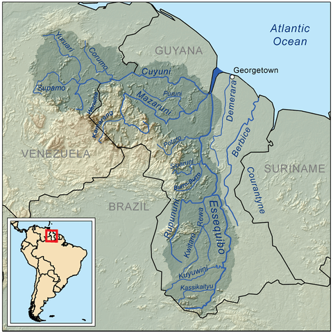
Map depicting the Essequibo River drainage basin.