Bolivia's Lakes Poopó & Uru Uru: Vanishing Waters
Bolivia's Altiplano once had a network of important water bodies that sustained ecosystems and communities. Among these were Lake Poopó and Lake Uru Uru. Recent environmental changes have caused these lakes to shrink or disappear entirely, leaving a landscape marked by ecological decline.
 https://www.flickr.com/photos/davidalmeida/15768282471")
, Oruro, Bolivia - by Viaje al corazón de Bolivia, CC BY 2.0, via Wikimedia Commons")
 https://www.flickr.com/photos/fingermann/12417509574/")
 via Wikimedia Commons")
 - by Chiliguanca / flickr, CC BY-SA")
 - by Mathias Fingermann via Flickr (CC BY-NC-ND 2.0) https://www.flickr.com/photos/fingermann/12417005295/")
 - by Golda Fuentes via Flickr (CC BY 2.0) https://www.flickr.com/photos/103682584@N05/13275532874/in/album-72157642612295013/")

The Disappearing Waters of Bolivia: Exploring Lakes Poopó, Uru Uru, and the Desaguadero River
Bolivia's Altiplano, a vast highland plateau surrounded by the towering Andes, was once home to a network of important water bodies that sustained ecosystems and communities. Among these were Lake Poopó and Lake Uru Uru, two saline lakes that formed part of an interconnected hydrological system fed by the Desaguadero River. However, recent environmental changes have caused these lakes to shrink or disappear entirely, leaving a landscape marked by ecological decline. The causes behind this transformation are complex, driven by both natural and human-induced factors. This examination of Lakes Poopó, Uru Uru, and the Desaguadero River delves into their historical significance, environmental challenges, and the impact of their decline on the region.
Lake Poopó: A Lost Giant of the Altiplano
Once Bolivia's second-largest lake, Lake Poopó was a sprawling saline body of water located on the Altiplano at an elevation of approximately 3,700 meters (12,100 feet). It stretched roughly 90 kilometers (56 miles) in length and 56 kilometers (20 miles) in width, covering a shallow depression in the high plains. Lake Poopó played a vital role in the region's hydrological system, receiving much of its water from the Desaguadero River, which originates from Lake Titicaca to the north.
Historically, Lake Poopó was a crucial ecological site, providing habitat for various bird species and acting as a buffer for seasonal water variations in the Altiplano. In 2002, the lake was designated a conservation site under the Ramsar Convention. However, despite this recognition, the lake's fate changed dramatically. By the end of 2015, Lake Poopó had completely dried up, leaving behind only remnants of marshland.
The causes of Lake Poopó's disappearance are multifaceted. Climate change has accelerated the melting of glaciers in the Andes, which historically fed the lake's water supply. Additionally, increasing water diversion for mining and agriculture severely reduced the inflow from the Desaguadero River. As the lake dried, its loss devastated the region's biodiversity and the livelihoods of communities that depended on its resources.
Lake Uru Uru: A Smaller Neighbor Facing Similar Perils
Located north of Lake Poopó in the Oruro Department, Lake Uru Uru has also faced environmental challenges. This smaller saline lake, with a surface area of 214 square kilometers (82.6 square miles), lies at an elevation of 3,686 meters (12,093 feet). Fed by the Desaguadero and Jach'a Jawira rivers, it played a significant role in the local ecosystem and economy. The nearby city of Oruro, a mining center, relied on the lake for its water supply, as did Indigenous communities that traditionally fished its waters.
Like its larger counterpart, Lake Uru Uru has seen dramatic water levels decline, most notably during a severe drought in 2016, when much of the lake's water vanished. This recurring pattern of desiccation is attributed to many of the same factors that contributed to the drying of Lake Poopó—climate change, unsustainable water management, and the impact of regional mining activities. The shrinking of Lake Uru Uru has compounded environmental pressures in the Altiplano, further straining local communities and wildlife.
The Desaguadero River: A Lifeline in Decline
The Desaguadero River, originating at the southern end of Lake Titicaca, has long been a critical water source for the Altiplano's lake system. It drains roughly 5% of Lake Titicaca's excess water, meandering southward for over 300 kilometers (200 miles) before reaching the lakes of Uru Uru and Poopó. Along its course, the river provides water for irrigation, small-scale fishing, and the livelihoods of Indigenous communities such as the Uru Muratu people.
While the Desaguadero River remains navigable by small boats, its flow has diminished due to various factors. Water extraction for agriculture, combined with reduced glacial meltwater due to climate change, has lessened the river's ability to sustain Lake Poopó and Lake Uru Uru. This dwindling flow has exacerbated the lakes' already precarious situation, contributing to their shrinkage and, in the case of Poopó, complete disappearance.
Environmental and Socioeconomic Impact
The decline of Lakes Poopó and Uru Uru, along with the reduced flow of the Desaguadero River, has far-reaching ecological consequences. Numerous species of birds, fish, and other wildlife that depend on the lakes' ecosystems are threatened by their loss. Flamingos, once abundant around Lake Poopó, have seen their numbers dwindle.
Socioeconomically, the drying of the lakes has had a devastating effect on local communities. Indigenous groups such as the Uru Muratu, who traditionally lived off fishing, have seen their way of life erode. Furthermore, the disappearance of Lake Poopó has caused a rise in respiratory and eye diseases due to dust storms originating from the lake's dry bed, which now consists of fine saline particles.
Conclusion
The story of Lakes Poopó and Uru Uru, along with the Desaguadero River, highlights the fragility of Bolivia's Altiplano environment in the face of climate change and human activity. The drying of these once vital water bodies has left a profound ecological and human toll, underscoring the region's need for sustainable water management and climate mitigation strategies. As climate shifts continue to alter the hydrological patterns of the Altiplano, the future of this landscape, its people, and its wildlife remains uncertain. Yet, through conservation efforts and awareness, there may still be hope for preserving what remains of Bolivia's disappearing waters.
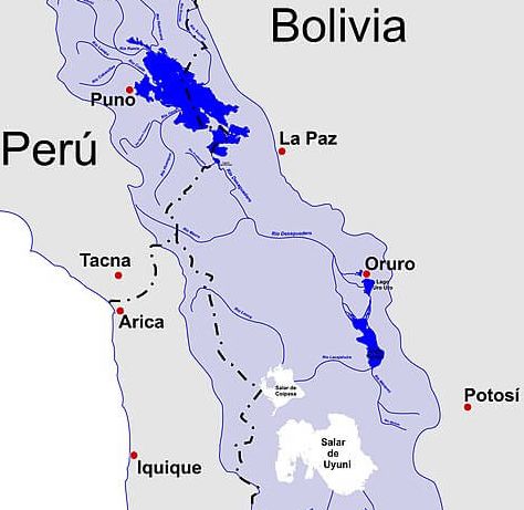
Map depicting Lake Titicaca, Rio Desaguadero, Lago Poopó, Lago Uru Uru and the Salar de Uyuni basin.