The Natural Splendor of Cerro Castillo National Park
Cerro Castillo National Park, located in the Aysén Region of southern Chile, is a stunning example of Patagonia's natural beauty and biodiversity. Named after the majestic Cerro Castillo peak, the park is a haven for those seeking to experience southern Chile's raw, unspoiled wilderness.


 https://www.flickr.com/photos/sergejf/38687129795")

Cerro Castillo National Park: A Gem in the Patagonian Andes
Cerro Castillo National Park, located in the Aysén Region of southern Chile, is a stunning example of the natural beauty and biodiversity that Patagonia has to offer. Named after the majestic Cerro Castillo peak, the park is a haven for outdoor enthusiasts, nature lovers, and anyone seeking to experience the raw, unspoiled wilderness of southern Chile. With its dramatic landscapes, diverse ecosystems, and rich wildlife, Cerro Castillo National Park provides a unique and captivating glimpse into the heart of the Patagonian Andes.
The Majestic Cerro Castillo
Cerro Castillo, the park's namesake, is a magnificent rocky peak rising to 2,675 meters (8,776 feet) above sea level. It is one of the highest peaks in the Patagonian Andes and stands as an imposing castle of rock and ice. Located approximately 75 kilometers (46 miles) south of Coyhaique, Cerro Castillo dominates the landscape with its small glaciers, snowdrifts, and vibrant blue lagoons. The mountain is renowned for its challenging and scenic trekking routes, particularly the Las Horquetas Trail System, a 53.5-kilometer (33.2-mile) circuit considered one of the most beautiful in Chile. This trail offers courses of varying difficulty, ranging from 1.5 to 7 hours in duration and 2.5 to 15.5 kilometers (1.5 to 9.5 miles) in length.
Establishment and Expansion of the National Park
Cerro Castillo National Park was initially established as a National Reserve in 1970. In 2017, a decree was signed to elevate its status to a National Park, expanding its protected area to 138,164 hectares (341,410 acres). The park's formation is part of a larger conservation effort stemming from an agreement between the Chilean government and Tompkins Conservation in March 2018. This agreement led to the creation of five new national parks and the expansion of three others, significantly increasing the protected areas in Patagonia.
Route of Parks
Cerro Castillo National Park is a key part of Chile's "Route of Parks," a 2,800-kilometer (1,700-mile) scenic route that stretches from Puerto Montt in the north to Cape Horn in the south. This route connects 17 national parks, encompassing one-third of Chile and protecting over 11.8 million hectares (28 million acres) of pristine wilderness. The Route of Parks aims to promote conservation, sustainable tourism, and the appreciation of Chile's natural heritage.
Diverse Landscapes and Ecosystems
Cerro Castillo National Park features a variety of landscapes and ecosystems, making it a unique destination for visitors. The park's landscape is characterized by hanging glaciers that form turquoise lagoons, such as Laguna Cerro Castillo and Laguna Chiguay. It is divided into three independent sectors: Lake Elizalde, Lake Paloma, and Cerro Castillo.
The park's northern portion is part of the Aisén River basin, while the southern portion falls within the Ibáñez River basin. The diverse vegetation includes five distinct types:
- Andean Antiboreal Desert
- Temperate Mediterranean Steppe
- Andean Temperate Deciduous Forest
- Andean Temperate Evergreen Forest
- Vegas and Wetlands
Rich Flora and Fauna
Cerro Castillo National Park is home to a rich array of flora and fauna. The Lenga and Ñirre forests provide habitat for the endangered Huemul (Hippocamelus bisulcus), a South Andean Deer native to the mountains of Argentina and Chile. The park also protects other significant species such as the Puma (Felis concolor), Guanaco (Lama guanicoe), Patagonian Chingue (Conepatus humboldti), and the Culpeo Fox (Pseudalopex culpaeus).
Birdlife in the park is equally diverse, with notable species including the Austral Parakeet, Andean Condor, Thorn-tailed Rayadito, Magellanic Woodpecker, Chucao, and Magellanic Tapaculo. These species contribute to the park's vibrant and dynamic ecosystem.
Outdoor Activities and Visitor Experience
Cerro Castillo National Park offers a wide range of outdoor activities, making it a popular destination for adventurers and nature enthusiasts. The park's trekking routes, particularly the Las Horquetas Trail System, provide various options for hikers of all skill levels. The trail system includes routes of varying difficulty and length, allowing visitors to explore the park's stunning landscapes at their own pace.
In addition to trekking, the park offers wildlife watching, photography, and nature observation opportunities. The diverse flora, fauna, and breathtaking scenery make Cerro Castillo National Park a paradise for photographers and nature lovers.
For those interested in camping, the park provides designated camping areas where visitors can immerse themselves in the natural beauty of the Patagonian wilderness. Camping in the park allows visitors to experience the region's tranquility and serenity, surrounded by the sounds of nature and the star-filled Patagonian night sky.
Conservation and Environmental Impact
Cerro Castillo National Park plays a crucial role in conserving the Patagonian Andes' unique ecosystems and biodiversity. The park's establishment and expansion have helped protect vital habitats for numerous endangered and threatened species. The conservation efforts within the park are supported by both the Chilean government and various environmental organizations, including Tompkins Conservation.
The park's inclusion in the Route of Parks highlights its significance in the broader context of Patagonia's conservation landscape. The Route of Parks initiative promotes sustainable tourism and environmental stewardship, encouraging visitors to appreciate and protect the natural wonders of southern Chile.
Conclusion
Cerro Castillo National Park stands as a testament to the breathtaking beauty and ecological significance of the Patagonian Andes. Its towering peaks, glacial lagoons, diverse ecosystems, and rich wildlife make it a must-visit destination for those seeking to immerse themselves in the natural wonders of southern Chile. As part of the Route of Parks, the park not only showcases the splendor of Patagonia but also underscores the importance of conservation and sustainable tourism in preserving these unique landscapes for future generations.
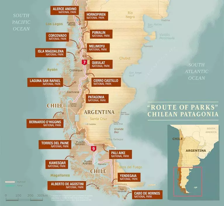
Chile's Route of Parks map - Thompson Conservation