Melimoyu National Park: The Untouched Wilderness of Chile
Melimoyu National Park, located in the Aysén Region in southern Chile, is a pristine wilderness offering a unique blend of natural beauty and biodiversity. Dominated by the imposing Melimoyu Volcano, this park is a sanctuary of lush forests, glaciers, fjords, and diverse wildlife.


Exploring Melimoyu National Park: A Hidden Gem of Chile
Melimoyu National Park, nestled in the northern part of the Aysén Region in southern Chile, is a pristine wilderness offering a unique blend of natural beauty and biodiversity. Dominated by the imposing Melimoyu Volcano, this park is a sanctuary of lush forests, glaciers, fjords, and diverse wildlife. Although it remains largely inaccessible to the public, the park's untouched landscapes and ecological significance make it a notable area for conservation and study. Exploring the park's geography, natural features, flora and fauna, and its role within the broader conservation efforts in Chile reveals its importance as a natural preserve and potential for future ecological research.
The Majestic Melimoyu Volcano
Melimoyu Volcano is a prominent stratovolcano that rises to approximately 2,400 meters (7,900 feet) and stretches 10 kilometers (6.2 miles). The volcano's elongated shape and four summits define its imposing presence. Part of the Southern Volcanic Zone, Melimoyu owes its formation to the subduction of the Nazca Plate beneath the South American Plate, a process that generates significant volcanic activity. While Melimoyu has not erupted recently, it has experienced two significant eruptions during the Holocene Period, spreading ash across vast distances.
The volcano is crowned with an ice cap, which supports seven glaciers: Glaciar Correntoso, Glaciar Melimoyu Este, Glaciar Marchant, Glaciar Melimoyu Sur, Glaciar Melimoyu Oeste, Glaciar Santo Domingo, and Glaciar Anihue. These glaciers play a crucial role in the park's hydrology, feeding the numerous rivers and streams that traverse the landscape. The presence of these glaciers also fosters a range of unique ecological niches, supporting diverse plant and animal life.
Geography and Surroundings
Melimoyu National Park spans approximately 104,500 hectares (258,000 acres), forming a natural boundary between the temperate rainforest and the northern reaches of the Patagonian subantarctic forest. The Gulf of Corcovado borders it to the north, the Moraleda Channel to the west, and the Jacaf Channel to the south. The park also includes much of Refugio Island and is encircled by a labyrinth of channels, fjords, and islands, creating a dramatic and complex landscape.
The park's climate is temperate and rainy, a key factor in maintaining its lush and biodiverse ecosystems. Due to the challenging terrain and lack of infrastructure, much of the park is accessible only by sea, preserving its untouched natural state. This isolation has allowed the park's ecosystems to thrive with minimal human disturbance, making it an invaluable site for conservation.
Historical Significance
Melimoyu National Park was established in 2018 through an agreement between the Chilean government and Tompkins Conservation. This landmark collaboration led to the creation of five new national parks and the expansion of three existing ones. The parks created under this agreement include Melimoyu National Park, Patagonia National Park, Kawésqar National Park (an extension of the Alacalufes National Reserve), Cerro Castillo National Park, and Pumalín Douglas Tompkins National Park. The expanded parks include Hornopirén National Park, Corcovado National Park, and Isla Magdalena National Park.
This agreement marked a significant step in Chile's conservation efforts, aiming to protect the country's unique and diverse ecosystems. The creation and expansion of these parks have helped safeguard millions of hectares of wilderness, ensuring that these natural landscapes remain preserved for future generations.
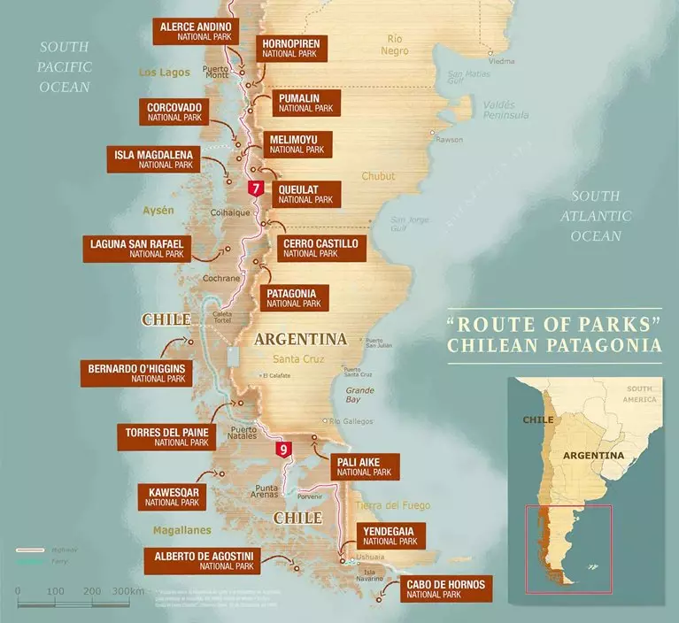
The Route of Parks: A Scenic Journey
Melimoyu National Park is part of Chile's renowned "Route of Parks," a 2,800-kilometer (1,700-mile) scenic trail that stretches from Puerto Montt to Cape Horn. This route encompasses 17 national parks and protects over 11.8 million hectares (28 million acres), making it a significant component of Chile's conservation strategy. The Route of Parks promotes the preservation of these natural areas and encourages sustainable tourism, allowing visitors to experience southern Chile's stunning landscapes and rich biodiversity.
Flora and Fauna: A Biodiversity Hotspot
The ecosystems within Melimoyu National Park are characterized by dense forests that feature a mix of species from both the Valdivian rainforest and temperate resinous forests. These forests stretch inland from the coast, creating a lush and varied landscape. Prominent tree species include Ciprés de la Guaitecas (Pilgerodendron), Tepú, Lenga Beech, Coigue, Mañío, and Magellan's Beech. These trees provide critical habitat for a range of animal species and help maintain the park's ecological balance.
The park is home to a variety of wildlife, including Darwin's Frog, Puma, Fox, Pudú Deer, and numerous bird species that thrive in the park's diverse habitats. The surrounding waters support marine life, such as the Chilean Dolphin, Peale's Dolphin, Humpback Whale, and Blue Whale, as well as various penguins, seals, and sea lions. This rich biodiversity highlights the ecological importance of Melimoyu National Park and underscores the need for its continued protection.
Conclusion
Melimoyu National Park is a testament to southern Chile's natural beauty and biodiversity. Its volcanic landscapes, glacial features, and rich ecosystems make it a crucial area for conservation. As part of the broader Route of Parks initiative, Melimoyu contributes to preserving Chile's natural heritage, ensuring that these pristine environments remain protected for future generations.
Chile's Route of Parks map - Thompson Conservation