Tierra del Fuego: The Last Frontier at the End of the World
At South America's southern tip lies one of Earth's enigmatic regions. Tierra del Fuego—the "Land of Fire"—testifies to the planet's beauty. This archipelago, shaped by geological forces and centuries of ice and wind, embodies humanity's fascination with the edges of the known world.

 https://www.flickr.com/photos/hbarrison/39068564975/in/album-72157665107438038/")


 https://www.flickr.com/photos/ru_boff/8584836653")
 at the Tierra del Fuego National Park - via Wikimedia Commons")
 via Wikimedia Commons")
 and gulls on Isla Magdalena, Strait of Magellan - by Steve Deger / (CC BY 2.0) via Wikimedia Commons")
 https://www.flickr.com/photos/mariano-mantel/13893719846/in/photostream/")
 https://www.flickr.com/photos/mariano-mantel/13955357725/")
Fire and Ice: Exploring South America's Last Wilderness Frontier
At the southernmost extremity of South America, where the continent fragments into a thousand islands scattered across tempestuous seas, lies one of Earth's most enigmatic and untamed regions. Tierra del Fuego—the "Land of Fire"—stands as a testament to the planet's capacity for both savage beauty and delicate complexity. This archipelago, thrust into existence by titanic geological forces and sculpted by millennia of ice and wind, represents more than a mere geographical curiosity; it embodies humanity's eternal fascination with the edges of the known world, where civilization yields to wilderness and where the very elements seem to conspire against human habitation.
Ferdinand Magellan, the Portuguese explorer who first glimpsed these shores in 1520, bestowed upon the archipelago its evocative name after witnessing the countless fires lit by Indigenous peoples along the coastline. What he could not have foreseen was that this "Land of Fire" would become a crucible of human endurance, scientific discovery, and environmental complexity that continues to challenge and inspire visitors more than five centuries later.
The Geographic Mosaic: A Land Divided Yet United by Nature
Isla Grande de Tierra del Fuego: The Heart of the Archipelago
The centerpiece of this remarkable region is Isla Grande de Tierra del Fuego, a landmass of extraordinary diversity that encompasses 48,100 square kilometers (18,572 square miles) of some of the most varied terrain on Earth. This island, the largest in South America, serves as a living laboratory where visitors can witness the dramatic interplay between geological forces, climatic extremes, and biological adaptation that defines the entire region.
The island's political division between Chile and Argentina, established through decades of diplomatic negotiations and territorial agreements, reflects the complex colonial history of southern South America. Yet this artificial boundary seems almost insignificant when viewed against the backdrop of the island's natural unity—a single ecosystem that spans national borders and demonstrates nature's indifference to human political constructs.
The division roughly follows the island's natural geographic features, with Chile controlling the mountainous western regions and most of the smaller southern islands, while Argentina administers the eastern plains and the strategically important northern coast. This arrangement has created unique opportunities for cross-border cooperation in conservation efforts while also presenting challenges for coordinated environmental management.
The Chilean Domain: Wilderness and Weather
The Chilean portion of Tierra del Fuego encompasses some of the most remote and inhospitable terrain in the Western Hemisphere. Here, the Magallanes y Antártica Chilena Region extends its jurisdiction over vast expanses of virtually uninhabited wilderness, where ancient forests cling to steep mountainsides and glaciers descend nearly to sea level.
Puerto Williams, officially recognized as the world's southernmost city, serves as the region's administrative center and a gateway to the largely unexplored islands that stretch southward toward Antarctica. With a population of fewer than 3,000 inhabitants, Puerto Williams represents the tenuous foothold of human civilization at the planet's edge, where residents must contend with some of the world's most challenging weather conditions and geographic isolation.
The town of Porvenir, situated on the shores of Bahía Inútil (Useless Bay)—itself named by early explorers who found its waters unsuitable for safe harbor—exemplifies the challenges of establishing permanent settlements in this unforgiving environment. Despite its modest size, Porvenir serves as a crucial link between the archipelago's scattered communities and the outside world, maintaining essential services and infrastructure that support both local residents and the growing number of researchers and tourists drawn to the region.
The Argentine Territory: Gateway to Adventure
The Argentine side of Tierra del Fuego presents a dramatically different landscape, dominated by rolling grasslands, ancient forests, and the bustling city of Ushuaia. As the provincial capital and the archipelago's largest urban center, Ushuaia has evolved from a remote penal colony established in the late 19th century into a modern gateway for Antarctic exploration and Patagonian adventure tourism.
Ushuaia's transformation reflects the broader evolution of Tierra del Fuego from a harsh frontier outpost to a destination that attracts hundreds of thousands of visitors annually. The city's strategic location on the Beagle Channel provides sheltered harbor facilities for cruise ships, research vessels, and private yachts, while its modern airport connects the region to Buenos Aires and other major South American cities.
Río Grande, the island's second-largest city, represents a different facet of Argentine Tierra del Fuego, serving as a center for sheep ranching, oil extraction, and light manufacturing. The contrast between Río Grande's industrial character and Ushuaia's tourism-focused economy illustrates the diverse economic strategies that different communities have adopted to thrive in this challenging environment.
The Cordillera Darwin: A Monument to Geological Violence
The Backbone of Fire and Ice
Rising from the archipelago's heart like the spine of some primordial beast, the Cordillera Darwin represents one of the most spectacular mountain ranges on Earth. This extension of the Patagonian Andes showcases the raw power of tectonic forces that continue to shape South America's southern extreme, where the Scotia Plate grinds against the South American Plate in a slow-motion collision that has been building mountains and carving valleys for millions of years.
The range's four distinct regions each tell a different chapter in the geological story of Tierra del Fuego. The Western Cordillera, with its heavily glaciated peaks and precipitous valleys, demonstrates the ongoing power of ice to sculpt landscape on a massive scale. Here, glaciers that originated during the last ice age continue their relentless advance and retreat, carving new valleys and depositing massive moraines that reshape the terrain with each passing century.
The Eastern Cordillera presents a gentler face, where the mountains give way to rolling hills blanketed in ancient forests and dotted with pristine lakes. This transition zone, located between the alpine heights and the coastal plains, supports some of the region's most diverse ecosystems, where species from both mountain and maritime environments intermingle in complex ecological relationships.
Mount Darwin: Sentinel of the South
Mount Darwin, towering 2,488 meters (8,163 feet) above the surrounding landscape, stands not merely as the highest peak in the Cordillera Darwin but as a symbol of the region's untamed character. Named in honor of Charles Darwin, whose observations during the voyage of HMS Beagle contributed profoundly to our understanding of evolution and natural selection, the mountain serves as a fitting monument to scientific inquiry and human curiosity about the natural world.
The mountain's challenging climbing conditions—unpredictable weather, technical rock and ice routes, and extreme isolation—have made it a coveted destination for mountaineers seeking to test their skills against one of the world's most demanding peaks. Successful ascents require not only technical expertise but also the ability to endure weeks of harsh conditions in one of the planet's most remote locations.
The Darwin Massif, which includes Mount Darwin and several neighboring peaks, represents a crucial watershed for the region, collecting moisture from Pacific storms and channeling it through ancient valley systems toward both the Atlantic and Pacific Oceans. This hydrological complexity supports diverse ecosystems and provides freshwater resources for communities throughout the archipelago.
The Southern Patagonian Ice Field: Antarctica's Northern Outpost
The vast Southern Patagonian Ice Field, which blankets much of the southern Cordillera Darwin, represents the largest expanse of ice in the Southern Hemisphere outside of Antarctica itself. This remnant of the last ice age continues to influence regional climate patterns, serving as a massive air conditioning system that moderates temperatures throughout Tierra del Fuego and affects weather patterns across southern South America.
The ice field's numerous outlet glaciers provide dramatic evidence of climate change, with many showing rapid retreat over the past century. Scientists from around the world study these glaciers as indicators of global warming trends, using sophisticated monitoring equipment to track changes in ice thickness, flow rates, and terminal positions. The data collected here contributes to global climate models and helps predict future sea-level changes.
Climate: Where Extremes Converge
The Battle of Air Masses
Tierra del Fuego's climate represents a complex battleground where air masses from the Pacific, Atlantic, and Antarctic regions converge in an ever-changing dance of meteorological extremes. The archipelago's position at the convergence of major ocean currents—the cold Humboldt Current from the Pacific and the warmer Brazil Current from the Atlantic—creates unique conditions that support both temperate rainforests and semi-arid steppes within a relatively small geographic area.
The western regions of the archipelago experience some of the most extreme precipitation levels on Earth, with annual rainfall exceeding 3,000 millimeters (118 inches) in some locations. This extraordinary moisture load, delivered by Pacific storms that sweep across the archipelago with relentless frequency, supports the growth of temperate rainforests that rival those of the Pacific Northwest in their lushness and biological diversity.
In stark contrast, the eastern regions lie in the rain shadow of the Cordillera Darwin, receiving less than 300 millimeters (12 inches) of precipitation annually. This dramatic gradient creates a landscape mosaic where travelers can experience both rainforest and semi-desert conditions within a few hours' journey, providing striking evidence of topography's influence on local climate patterns.
The Wind Factor: Nature's Relentless Force
Perhaps no aspect of Tierra del Fuego's climate is more notorious than its winds, which have earned the region a reputation as one of the windiest places on Earth. The infamous "Roaring Forties" and "Furious Fifties"—latitude bands known for their persistent westerly winds—converge over the archipelago, creating conditions that can challenge even the most experienced sailors and aviators.
These winds, generated by the massive pressure differentials between the Pacific and Atlantic high-pressure systems, can exceed 200 kilometers per hour (120 miles per hour) during severe storms. The constant wind stress has profoundly influenced the region's vegetation, creating forests of trees sculpted into bizarre shapes by decades of relentless air movement, and grasslands where plants grow in tight mats to resist the constant buffeting.
Ecosystems: Evolution's Laboratory
The Magellanic Subpolar Forests: A Botanical Ark
The Magellanic subpolar forests, which cover approximately 30% of the Tierra del Fuego archipelago, represent one of the world's most unique forest ecosystems, harboring species found nowhere else on Earth. These forests serve as living museums of plant evolution, containing species that have survived virtually unchanged since the breakup of the supercontinent Gondwana millions of years ago.
The forest's dominant species each tell a story of adaptation to extreme conditions. Drimys winteri (Winter's bark or canelo), with its aromatic bark that provided early explorers with a source of vitamin C to prevent scurvy, can reach heights of 30 meters (98 feet) despite growing in some of the world's harshest temperate conditions. The species' ability to photosynthesize year-round, even during the brief austral summer, represents a remarkable adaptation to the region's limited growing season.
Pilgerodendron uviferum, known locally as lenga, holds the distinction of being the world's southernmost conifer. These ancient trees, some of which have lived for over 3,000 years, grow with extraordinary slowness, adding only millimeters to their girth each year. Their twisted, gnarled forms—sculpted by centuries of wind and weather—create forest landscapes that seem almost otherworldly in their stark beauty.
The Nothofagus genus, represented by several species including Antarctic beech (Nothofagus antarctica) and lenga dwarf beech (Nothofagus pumilio), illustrates the evolutionary relationships between the South American and Australian floras, providing evidence for the former connection between these now-distant continents. These deciduous trees create spectacular autumn displays, their leaves turning brilliant shades of red, orange, and gold before falling to create thick carpets on the forest floor.
Tundra Transitions: Life at the Limit
As the forests give way to tundra in the archipelago's southernmost reaches, visitors encounter some of the world's most extreme plant communities. The Wollaston Islands and the southern portions of Hoste Island support sub-Antarctic tundra ecosystems where only the hardiest species can survive the combination of constant wind, poor soils, and extremely short growing seasons.
These tundra communities, dominated by cushion plants, grasses, and lichens, represent evolutionary masterpieces of adaptation to extreme conditions. Many species grow in tight mats or cushions that help conserve heat and moisture while resisting wind damage. Some plants complete their entire annual growth cycle in just a few weeks during the brief austral summer, storing energy in underground structures that allow them to survive the long, harsh winters.
Wildlife: Survivors in a Harsh Paradise
Endemic Species and Evolutionary Marvels
Tierra del Fuego's isolation has created unique evolutionary opportunities, resulting in several endemic species found nowhere else on Earth. The Fuegian fox (Lycalopex culpaeus lycoides), a subspecies of the culpeo fox, has adapted to the archipelago's harsh conditions by developing a thicker coat and altered hunting behaviors that allow it to survive on a diet of berries, small mammals, and carrion during the lean winter months.
The Magellanic woodpecker (Campephilus magellanicus), South America's largest woodpecker, serves as a flagship species for forest conservation efforts. These magnificent birds, with their striking black and red plumage, require old-growth forests with large dead trees for nesting and foraging. Their presence serves as an indicator of forest health, and their conservation needs have helped protect vast areas of ancient woodland.
The region's marine ecosystems support equally remarkable wildlife populations. Southern right whales, once hunted nearly to extinction, have made a remarkable recovery in the protected waters around Tierra del Fuego. These massive mammals, which can reach lengths of 18 meters (60 feet) and weights of 80 tons, use the sheltered bays and channels as calving grounds and nurseries for their young.
The Beaver Invasion: An Ecological Catastrophe
The introduction of North American beavers (Castor canadensis) to Tierra del Fuego in 1946 represents one of the most dramatic examples of ecological disruption caused by invasive species. Originally imported by the Argentine government to establish a fur industry, the beavers quickly escaped captivity and began colonizing the island's waterways with devastating effect.
Unlike North American ecosystems, which evolved alongside beavers and their dam-building activities, Tierra del Fuego's forests and waterways had no natural defenses against these ecosystem engineers. Beaver dams have flooded thousands of hectares of ancient woodland, killed countless trees, and altered stream ecosystems throughout the archipelago. The current beaver population, estimated at over 100,000 individuals, continues to expand its range and impact.
Efforts to control the beaver population have involved both Chilean and Argentine governments in an unprecedented binational eradication program. Trapping, hunting, and habitat modification strategies are being employed to reduce beaver numbers, but the scale of the challenge and the animals' high reproductive rate make complete eradication extremely difficult and expensive.
Human Heritage: Indigenous Wisdom and Colonial Impact
The Original Inhabitants: Masters of Marine Adaptation
Long before European explorers reached these remote shores, Tierra del Fuego was home to several Indigenous groups who had developed sophisticated adaptations to one of the world's most challenging environments. The Yahgan (Yámana) people, who inhabited the southern channels and islands, created one of the world's most remarkable maritime cultures, living almost entirely from the resources of the sea.
The Yahgan (or Yaghan) people's intimate knowledge of marine ecosystems allowed them to thrive in conditions that challenged even modern explorers equipped with advanced technology. They developed sophisticated techniques for harvesting shellfish, fish, and marine mammals, while their bark canoes and waterproof clothing made from seal skins enabled them to navigate the treacherous waters of the Beagle Channel and its tributary waterways.
The Selk'nam (Ona) people occupied the interior grasslands of Isla Grande, developing a terrestrial hunting culture based on the pursuit of guanaco and other land mammals. Their deep understanding of animal behavior and seasonal patterns allowed them to maintain sustainable hunting practices that supported their population for thousands of years without depleting wildlife resources.
Tragically, European colonization brought devastating consequences for these Indigenous populations. Disease, territorial displacement, and systematic persecution reduced thriving communities to a handful of survivors within just a few decades. Today, efforts to preserve and revitalize Indigenous languages, cultural practices, and traditional ecological knowledge represent important steps toward acknowledging this tragic history and incorporating Indigenous wisdom into contemporary conservation strategies.
The Colonial Period: Exploitation and Exploration
The European colonization of Tierra del Fuego began with extractive industries that sought to exploit the region's natural resources with little regard for environmental sustainability or Indigenous rights. Sheep ranching, introduced in the late 19th century, transformed vast areas of native grassland into pastures for imported livestock, while the wool industry brought the first significant wave of European settlement to the region.
The discovery of gold in the 1880s triggered a brief but intense mining boom, bringing fortune seekers from around the world to the archipelago's beaches and rivers. While the gold rush was relatively short-lived, it established patterns of resource extraction and environmental disruption that would persist for decades.
The establishment of penal colonies, most notably the infamous prison at Ushuaia, reflected the European perception of Tierra del Fuego as a place of exile and punishment rather than a homeland worthy of respect and protection. These institutions, while contributing to the region's early infrastructure development, also reinforced negative stereotypes about the archipelago that persisted well into the 20th century.
Contemporary Challenges and Opportunities
Economic Diversification: Beyond Extraction
Modern Tierra del Fuego faces the challenge of transitioning from an economy based primarily on resource extraction to one that balances economic development with environmental sustainability. Traditional industries, such as sheep ranching, oil and gas extraction, and commercial fishing, continue to provide important economic benefits; however, their environmental costs have become increasingly apparent.
The region's emerging ecotourism industry presents promising opportunities for sustainable economic development, capitalizing on Tierra del Fuego's unique natural assets while providing incentives for conservation. Adventure tourism, including trekking, mountaineering, kayaking, and wildlife observation, attracts visitors willing to pay premium prices for authentic wilderness experiences.
World-class fishing opportunities, particularly for sea-run brown trout in rivers like the Rio Grande, the San Pablo, and around Lago Fagnano, have established Tierra del Fuego as a premier destination for sport fishing enthusiasts. These activities, when properly managed, provide significant economic benefits to local communities while maintaining relatively low environmental impacts.
Climate Change: Canary in the Coal Mine
Tierra del Fuego serves as an early warning system for global climate change, with its glaciers, forests, and marine ecosystems showing clear evidence of warming temperatures and shifting precipitation patterns. The retreat of glaciers in the Cordillera Darwin has accelerated dramatically over the past several decades, providing dramatic visual evidence of changing climatic conditions.
Changes in ocean temperature and chemistry are affecting marine food webs, with potential consequences for the whales, seals, and seabirds that depend on the region's rich marine resources. Warmer temperatures are also facilitating the expansion of invasive species and altering forest composition as tree species migrate southward in response to changing conditions.
Conservation Success Stories: International Cooperation
Despite the challenges facing Tierra del Fuego, several conservation success stories demonstrate the potential for effective environmental protection through international cooperation and community engagement. The establishment of transboundary protected areas, including Tierra del Fuego National Park in Argentina and the proposed binational marine protected area in the Beagle Channel, shows how political boundaries can be transcended in the service of conservation goals.
The recovery of southern right whale populations represents one of the region's most dramatic conservation successes. Strict protection measures implemented by both the Chilean and Argentine governments have enabled these magnificent marine mammals to recover from near extinction, resulting in healthy breeding populations that now attract thousands of whale-watching tourists annually.
Scientific Research: A Natural Laboratory
Ongoing Research Programs
Tierra del Fuego's unique combination of pristine ecosystems, extreme environments, and accessible research facilities has made it an important center for scientific research across multiple disciplines. Long-term ecological monitoring programs track changes in forest composition, glacier dynamics, and marine ecosystem health, providing crucial data for understanding global environmental change.
The region's role as a gateway to Antarctica has made it an important staging area for polar research expeditions, with Ushuaia serving as the departure point for hundreds of scientific missions to the southern continent. This connection has fostered collaboration between researchers in Tierra del Fuego and the international Antarctic scientific community, thereby enhancing the region's contribution to global environmental science.
Research stations throughout the archipelago conduct studies on topics ranging from the impacts of climate change on forest ecosystems to the behavior and ecology of marine mammals. These facilities provide opportunities for international scientific cooperation and training for the next generation of environmental researchers.
Future Visions: Sustainable Development at the End of the World
Balancing Growth and Conservation
The future of Tierra del Fuego hinges on finding sustainable solutions that strike a balance between economic development and environmental protection. This challenge requires innovative approaches that recognize the intrinsic value of the region's natural assets while providing economic opportunities for local communities.
Sustainable tourism development offers perhaps the greatest potential for achieving this balance, but only if carefully managed to prevent the environmental degradation that has affected other pristine destinations around the world. Strict carrying capacity limits, seasonal restrictions, and mandatory environmental education programs could help ensure that tourism development enhances rather than degrades the region's natural values.
The development of renewable energy resources, particularly wind and hydroelectric power, could reduce the region's dependence on fossil fuels while harnessing the area's abundant natural energy resources. Such projects must be carefully designed to minimize environmental impacts while maximizing benefits for local communities.
Lessons for a Changing World
Tierra del Fuego offers important lessons for addressing global environmental challenges. The region's experience with invasive species management, transboundary conservation, and sustainable tourism development provides models that can be applied in other remote and fragile ecosystems worldwide.
The Indigenous knowledge preserved by the region's original inhabitants offers valuable insights into sustainable resource management and adaptation to extreme environments. Integrating this traditional wisdom with modern scientific understanding could provide innovative solutions to contemporary environmental challenges.
Conclusion: Guardian of the Southern Frontier
Tierra del Fuego stands as more than a geographical curiosity at the world's end; it represents a crucible where the fundamental forces that shape our planet—geology, climate, evolution, and human culture—converge in spectacular and sometimes catastrophic ways. This archipelago of fire and ice serves as both a refuge for ancient species and ecosystems and a laboratory for understanding how life adapts to extreme conditions.
The challenges facing Tierra del Fuego—climate change, invasive species, economic development pressures, and the legacy of colonial exploitation—mirror those confronting wilderness areas worldwide. How successfully the region addresses these challenges will provide important lessons for conservation efforts worldwide and demonstrate whether it is possible to maintain wilderness values in an increasingly interconnected and human-dominated world.
The name "Land of Fire" has proven prophetic in ways that Magellan could never have imagined. The fires that gave the archipelago its name were not merely the hearth fires of Indigenous peoples but symbols of the human spirit's ability to find warmth and meaning in the most inhospitable places on Earth. Today, those fires burn in the passion of scientists working to understand climate change, conservationists fighting to protect endangered species, and travelers seeking authentic encounters with wild nature.
As we face an uncertain environmental future, Tierra del Fuego reminds us that some places on Earth remain largely beyond human control, where natural forces still dictate the terms of existence and where the humility required for survival in extreme conditions offers profound lessons about our relationship with the natural world. In preserving and protecting this remarkable archipelago, we not only preserve irreplaceable ecosystems and species but also ensure that future generations will continue to experience the transformative power of truly wild places.
The Land of Fire continues to burn—not with the destructive flames of environmental degradation but with the enduring flame of natural wonder that has the power to inspire, humble, and transform all who experience its harsh beauty. In safeguarding Tierra del Fuego, we safeguard something essential about what it means to be human on a planet where wilderness still exists at the very edges of the world.
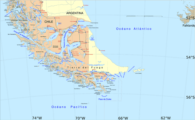
Map of the southern tip of South America / Tierra del Fuego.