The Colombian Andes: A Confluence of Nature and Civilization
The Colombian Andes represent the northern extension of the Andes system. They are divided into three parallel mountain chains: the Cordillera Occidental, Central, and Oriental. The Andean Natural Region, encompassing these mountain ranges, is Colombia's most populous natural region.

 https://www.flickr.com/photos/javierguillot/5584143266")
 https://www.flickr.com/photos/rutlo/2920948977/")
 in the Páramo de Guerrero of Colombia - by Friedrich Kircher CC BY 3.0 via Wikimedia Commons")


Exploring the Colombian Andes: A Land of Diverse Landscapes and Rich Culture
The Colombian Andes are a fascinating and complex part of the Andean mountain system, representing the northern extension of this vast range stretching along South America's western coast. The Andes divide into three parallel mountain chains in Colombia: the Cordillera Occidental, the Cordillera Central, and the Cordillera Oriental. These ranges, forming a backbone for the country, are vital to its geography and cultural and ecological identity. The Andean Natural Region, encompassing these mountain ranges, is Colombia's most populous natural region, hosting many urban centers and significant pre-Columbian settlements.
Geological Origins and Tectonic Activity
The geological formation of the Colombian Andes can be traced back millions of years to the interaction of tectonic plates. In the south, just north of the border with Ecuador, the Andes Mountains bifurcate into three parallel ranges at the Huaca Knot, a collection of snow-capped volcanoes. Further north, the Pasto mountain knot, an important hydrological source, marks the origin of these three cordilleras. The tectonic activities involving the Nazca Plate, the Caribbean Plate, and the South American Plate have shaped the dramatic landscapes of the Colombian Andes, creating a region rich in geological diversity.
The Three Cordilleras
Cordillera Occidental
The Cordillera Occidental, the westernmost range of the Colombian Andes, runs parallel to the Pacific coast. It is the least populated of the three ranges, with an average altitude of 2,000 meters (6,600 feet) and reaching its highest point at Cerro Tatamá, standing at 4,100 meters (13,500 feet). The range extends from south to north, eventually splitting into three smaller ranges that merge into the Caribbean plain and the Sinú River Valley. The relatively low elevation of the Cordillera Occidental permits dense tropical vegetation, especially on its western slopes. The range is separated from the coastal Baudó Mountains by the Atrato River and from the Cordillera Central by the deep rift of the Cauca Valley.
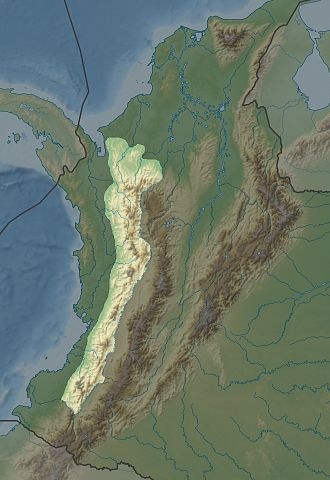
Map depicting the location of the Cordillera Occidental in Colombia.
Cordillera Central
The Cordillera Central is the highest and most prominent of the three branches of the Colombian Andes. It forms a formidable rock wall, extending 800 kilometers (500 miles) from north to south and dotted with snow-covered volcanoes. Among its highest peaks are Nevado del Tolima at 5,215 meters (17,105 feet), Nevado del Ruiz at 5,400 meters (17,717 feet), and Nevado del Huila at 5,750 meters (18,865 feet). The range widens into a plateau around the latitude of 6° N, where the city of Medellín, Colombia's second-largest city, is located. The Cauca River Valley bounds the Cordillera Central to the west and the Magdalena River Valley to the east. Toward its northern end, the range separates into several branches that descend toward the Caribbean coast.
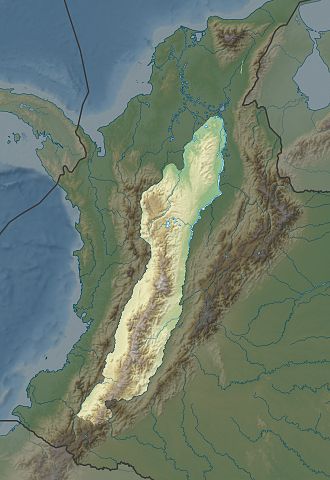
Map depicting the location of the Cordillera Central in Colombia.
Cordillera Oriental
The Cordillera Oriental is the easternmost and broadest of the three Colombian Andes ranges. It extends south to north, eventually splitting into the Serranía del Perijá and the Cordillera de Mérida in the Venezuelan Andes. The highest peak in this range is Ritacuba Blanco, which rises to 5,410 meters (17,750 feet) in the Sierra Nevada del Cocuy. The Altiplano Cundiboyacense, a high plateau within the Cordillera Oriental, covers parts of Cundinamarca and Boyacá and corresponds to the ancient territory of the Muisca civilization. The Colombian capital, Bogotá, is situated on this plateau. The Magdalena River Basin lies west of the range, while the Amazon, Orinoco, and Catatumbo Rivers' basins are located east.
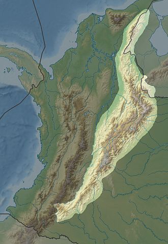
Map depicting the location of the Cordillera Oriental in Colombia.
The Andean Natural Region
The Andean Natural Region is Colombia's most populated natural region and includes most of the country's urban centers. This region is a geographical marvel and a hub of historical and cultural significance, housing many of the most important pre-Columbian indigenous settlements. Beyond the Colombian Massif in the southwestern departments of Cauca and Nariño, the Colombian Andes divide into three major branches: the Cordillera Occidental, home to the city of Cali; the Cordillera Central, encompassing the cities of Medellín, Manizales, and Pereira; and the Cordillera Oriental, extending northeast towards the Guajira Peninsula and including the cities of Bogotá, Bucaramanga, and Cúcuta.
The Andean Natural Region features various temperature zones, significantly influencing its vegetation and biodiversity. The region's ecological diversity is delineated by altitude, creating distinct environmental zones:
- Terra Caliente (Warm Land): This zone is found primarily in river valleys and basins below 1,000 meters (3,280 feet) in elevation. It is characterized by tropical climates and dense vegetation.
- Tierra Templada (Temperate Land): This zone, located between 1,000 and 2,000 meters (3,280 and 6,560 feet), has a moderate climate suitable for various agricultural activities.
- Tierra Fría (Cold Land): This zone, which extends from 2,000 to 3,200 meters (6,560 to 10,500 feet), includes some of the most productive agricultural lands and most of the population.
- Alpine Conditions: Above 3,200 meters (10,500 feet), the environment transitions into the zona forestada (forested zone), páramos (high-altitude moorlands) between 3,900 and 4,600 meters (12,800 to 15,100 feet), and finally the tierra helada (frozen land) at elevations above 4,600 meters (15,100 feet).
Numerous national parks in the Andean Natural Region preserve its unique ecosystems and offer a sanctuary for Colombia's diverse flora and fauna. These protected areas play a crucial role in conservation efforts, scientific research, and sustainable tourism, contributing to the region's ecological and economic sustainability.
Conclusion
The Colombian Andes, with their three distinct cordilleras, are a remarkable natural feature of South America, characterized by their geological complexity, ecological diversity, and cultural significance. From the tropical forests of the Cordillera Occidental to the snow-capped peaks of the Cordillera Central and the extensive high plateaus of the Cordillera Oriental, the region offers a rich tapestry of landscapes and habitats. The Andean Natural Region, the most populous area of Colombia, underscores the critical interplay between natural environments and human civilizations, shaping the country's history and future. Preserving the integrity and biodiversity of the Colombian Andes is essential for maintaining this extraordinary region's ecological balance and cultural heritage.
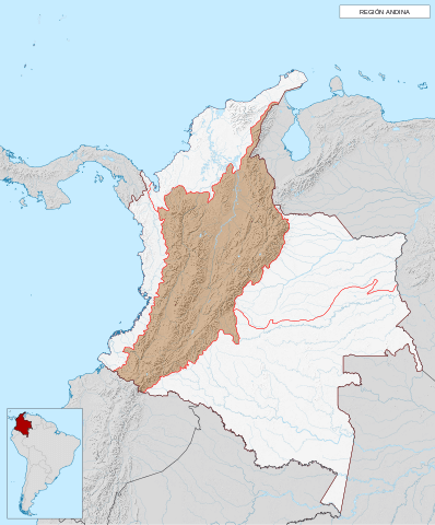
Map depicting the location of the Andean Natural Region of Colombia.