Argentina's Water Bodies: From Andean Lakes to Atlantic Shores
Argentina's vast territory spans from the subtropical north to the sub-Antarctic south, encompassing a diverse range of water bodies that influence its geography, ecology, and human development. These aquatic systems represent one of South America's most varied hydrological landscapes.

 https://www.flickr.com/photos/ru_boff/8584836653")

 and Maipo volcano (Chile) - Fortunat, CC BY-SA 3.0, via Wikimedia Commons")

 in Puerto Tirol (Chaco Province, Argentina) - by Pertile, CC BY-SA 4.0, via Wikimedia Commons")
Argentina's Hydrological Heritage: Rivers, Lakes, and Coastal Treasures
Argentina's vast territory stretches from the subtropical north to the sub-Antarctic south, encompassing an extraordinary variety of water bodies that have shaped the nation's geography, ecology, and human development. From the mighty rivers that drain the continent to pristine glacial lakes nestled in the Andes, these aquatic systems represent one of South America's most diverse hydrological landscapes. The country's water resources span over 2.8 million square kilometers (1.1 million square miles), creating ecosystems that support unique wildlife, sustain millions of inhabitants, and drive economic activity across multiple sectors.
The Paraná River System: Argentina's Arterial Waterway
The Paraná River forms the backbone of Argentina's most significant river system, serving as both a natural boundary and a vital transportation corridor. Stretching approximately 4,880 km (3,030 mi) from its source in Brazil to its mouth at the Río de la Plata, the Paraná represents the second-longest river in South America. Within Argentine territory, the river flows for roughly 1,200 km (746 mi), creating a complex network of channels, islands, and wetlands known as the Paraná Delta.
The river's massive discharge averages 17,290 m³/s (610,400 ft³/s) at its mouth, making it one of the world's most voluminous rivers. The Paraná's watershed encompasses portions of Brazil, Paraguay, Bolivia, and Argentina, draining an area of approximately 2.6 million square kilometers (1 million square miles). Major tributaries within Argentina include the Paraguay River, which adds substantial flow from the northern wetlands, and numerous smaller rivers that descend from the western highlands.
The Paraná Delta, where the river approaches Buenos Aires, represents one of Argentina's most ecologically significant regions. Covering approximately 14,000 km² (5,405 mi²), the delta consists of thousands of islands separated by an intricate network of channels and streams. The area experiences regular flooding cycles that deposit nutrient-rich sediments, creating fertile soils that support diverse plant and animal communities.
The Uruguay River: Eastern Boundary Waters
Flowing along Argentina's eastern border with Uruguay and Brazil, the Uruguay River represents another crucial component of the Río de la Plata basin. The river originates in the Serra do Mar of southern Brazil and flows approximately 1,838 km (1,142 mi) before joining the Paraná River. Within the Argentine watershed, the Uruguay River drains portions of Misiones, Corrientes, and Entre Ríos provinces.
The river's flow varies significantly with seasonal precipitation patterns, ranging from approximately 4,500 m³/s (158,900 ft³/s) during peak flow to as low as 300 m³/s (10,600 ft³/s) during dry periods. Several major dams along the river's course, including the Salto Grande Dam shared between Argentina and Uruguay, provide hydroelectric power and flood control while creating substantial reservoirs.
The Uruguay River's middle and lower reaches feature numerous rapids and falls, including the spectacular Moconá Falls, where the river drops approximately 10-12 m (33-39 ft) along a 3 km (1.9 mi) stretch. These geological features create unique ecosystems and contribute to the river's scenic beauty.
Andean Lakes: Glacial Jewels of Patagonia
The Argentine Andes host numerous pristine lakes formed by glacial activity during past ice ages. These water bodies, concentrated primarily in the provinces of Neuquén, Río Negro, Chubut, and Santa Cruz, represent some of South America's most spectacular natural features. The lakes typically occupy deep valleys carved by glaciers, creating bodies of water with exceptional depth and crystal-clear waters.
Northern Patagonian Lakes
The northern Patagonian lake district centers around Nahuel Huapi, Argentina's oldest national park. Lake Nahuel Huapi covers approximately 544 km² (210 mi²) and reaches depths of 464 m (1,522 ft), making it one of the region's largest and deepest lakes. The lake's complex shoreline features numerous bays, peninsulas, and islands, creating a diverse array of aquatic habitats.
Nearby Lake Lácar, located near San Martín de los Andes, covers 49 km² (19 mi²) and connects to the Pacific Ocean drainage through the Hua Hum River. The lake's pristine waters support native fish species and offer recreational opportunities, while also serving as a vital water source for regional communities.
Lake Traful, known for its distinctive turquoise color, occupies a narrow glacial valley approximately 76 km (47 mi) long. The lake's unusual coloration is due to suspended glacial flour and minerals dissolved from the surrounding volcanic rocks. Maximum depths reach approximately 215 m (705 ft), creating thermal stratification that supports unique aquatic ecosystems.
Southern Patagonian Giants
Further south, the Patagonian landscape features even more dramatic glacial lakes. Lake Argentino, located in Santa Cruz Province, covers approximately 1,466 km² (566 mi²) and represents Argentina's largest freshwater lake. The lake receives water from several glaciers, including the famous Perito Moreno Glacier, which periodically dams the lake's Brazo Rico arm, creating dramatic ice dam collapses.
Lake Viedma, connected to Lake Argentino through the Santa Cruz River, covers approximately 1,100 km² (425 mi²) and receives meltwater from the Southern Patagonian Ice Field. The lake's milky blue-green color is a result of glacial flour suspended in the water, creating an otherworldly appearance that attracts visitors from around the globe.
Coastal and Marine Waters
Argentina's extensive coastline along the South Atlantic Ocean stretches approximately 4,989 km (3,100 mi), creating diverse marine environments that support rich ecosystems and important economic activities. The continental shelf extends well beyond the coastline, creating productive fishing grounds that sustain both commercial and recreational fisheries.
The Río de la Plata
The Río de la Plata, technically an estuary rather than a traditional river, represents one of the world's largest river mouth systems. Formed by the confluence of the Paraná and Uruguay rivers, the estuary covers approximately 35,000 km² (13,514 mi²) and extends roughly 290 km (180 mi) from the rivers' confluence to the Atlantic Ocean.
The estuary's width varies from approximately 48 km (30 mi) at its narrowest point to over 220 km (137 mi) at its mouth. Despite its name, which translates to "River of Silver," the Río de la Plata contains brackish water due to mixing between freshwater inflow and Atlantic Ocean tides. The system supports important commercial navigation, connecting the Argentine interior to international shipping routes.
Patagonian Coastal Waters
The Patagonian coast boasts numerous gulfs, bays, and peninsulas, which create a network of protected marine environments. Peninsula Valdés, a UNESCO World Heritage Site, is characterized by two large gulfs: Golfo Nuevo and Golfo San José. These semi-enclosed water bodies support significant populations of marine mammals, including southern right whales, elephant seals, and sea lions.
The Valdés Peninsula region experiences extreme tidal ranges, with some areas showing tidal differences exceeding 9 m (30 ft). These dramatic tidal cycles create unique intertidal ecosystems, contributing to the area's exceptional marine biodiversity.
Wetland Systems: Argentina's Hidden Aquatic Treasures
Argentina contains several internationally significant wetland systems that provide crucial ecosystem services while supporting diverse wildlife populations. These wetlands range from subtropical marshes in the north to Patagonian peat bogs in the south, each adapted to specific climatic and geological conditions.
The Iberá Wetlands
Located in Corrientes Province, the Iberá Wetlands represent one of South America's largest freshwater wetland systems. Covering approximately 13,000 km² (5,019 mi²), the system consists of lagoons, marshes, floating islands, and gallery forests that support exceptional biodiversity.
The wetlands' name derives from the Guaraní word meaning "shining waters," reflecting the system's crystal-clear waters and abundant aquatic vegetation. The area supports over 4,000 animal species, including caimans, capybaras, marsh deer, and numerous bird species. Recent conservation efforts have established much of the wetlands as a national park, ensuring protection for future generations.
Patagonian Peat Bogs
The southern regions of Argentina contain extensive peat bog systems that have formed over thousands of years due to the region's cool, wet climate. These wetlands store vast amounts of carbon while supporting specialized plant communities adapted to acidic, nutrient-poor conditions.
The peat bogs play crucial roles in regional hydrology, acting as natural water storage systems that regulate stream flow and maintain water quality. Many bogs support unique species found nowhere else, including carnivorous plants and specialized mosses that create the bog's characteristic sphagnum carpet.
Underground Water Resources
Argentina possesses significant groundwater resources stored in various aquifer systems throughout the country. These underground water sources provide essential supplies for agriculture, industry, and municipal water systems, particularly in arid and semi-arid regions where surface water remains scarce.
The Guaraní Aquifer System
The Guaraní Aquifer System represents one of the world's largest groundwater reserves, extending beneath portions of Argentina, Brazil, Paraguay, and Uruguay. Within Argentine territory, the aquifer underlies approximately 225,500 km² (87,065 mi²), primarily in the northeastern provinces.
The aquifer contains an estimated 37,000 km³ (8,877 mi³) of water, with Argentine portions holding roughly 6,920 km³ (1,660 mi³). Water quality varies throughout the system, with some areas producing excellent drinking water while others contain higher mineral concentrations suitable primarily for industrial or agricultural use.
Pampean Aquifers
The Pampean region relies heavily on groundwater resources stored in sedimentary aquifers beneath the fertile plains. These aquifers supply water for Argentina's most productive agricultural areas while supporting major urban centers, including Buenos Aires.
The Pampean aquifer system consists of multiple water-bearing layers at various depths, with water quality generally decreasing with depth due to increased mineral content. Careful management of these resources remains essential for sustainable development in Argentina's most economically important region.
Economic and Environmental Significance
Argentina's water bodies provide immense economic value through multiple sectors, including agriculture, industry, transportation, energy generation, and tourism. The country's rivers serve as major transportation corridors, moving agricultural products from interior regions to export terminals along the coast. Hydroelectric facilities along various rivers generate significant portions of Argentina's electricity supply while providing flood control and water storage.
The fishing industry depends heavily on both freshwater and marine systems, with commercial operations targeting species in rivers, lakes, and coastal waters. Recreational fishing also contributes substantially to regional economies, particularly in Patagonian destinations known for world-class trout fishing.
Tourism centered around water bodies generates billions of dollars annually, from luxury resorts along Patagonian lakes to eco-tourism operations in wetland areas. The scenic beauty and recreational opportunities offered by Argentina's waters attract millions of visitors each year, supporting thousands of jobs in the hospitality and related services sectors.
Environmental challenges facing Argentina's water resources include pollution from agricultural runoff, industrial discharge, and urban development. Climate change poses additional threats through altered precipitation patterns, glacial retreat, and increased frequency of extreme weather events. Conservation efforts focus on protecting critical watersheds, establishing protected areas, and implementing sustainable water management practices to ensure the long-term health of these ecosystems.
Summary
Argentina's water bodies represent an extraordinary natural heritage that encompasses mighty rivers, pristine glacial lakes, productive coastal waters, and vital wetland systems. From the massive Paraná River system, which drains much of south-central South America, to the crystal-clear lakes of Patagonia formed by ancient glacial activity, these aquatic resources have shaped the nation's geography, ecology, and economic development. The country's extensive coastline and underground aquifer systems add further dimensions to this hydrological wealth, supporting diverse ecosystems and human activities across varied climatic zones. While these water resources provide immense economic and environmental benefits, they face mounting pressures from development, pollution, and climate change, making conservation and sustainable management increasingly critical for Argentina's future prosperity and ecological health.
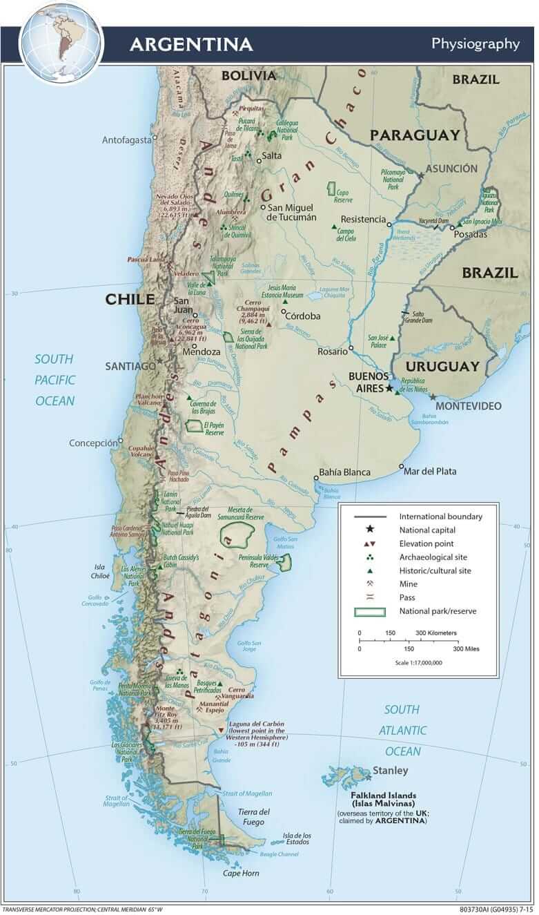
Argentina physiographic map.
Argentina's Major Water Bodies: Reference List
Lakes and Lagoons
Glacial Lakes (Patagonia and Andes)
- Lake Argentino (Santa Cruz) - 1,415 km² (546 mi²), 500 m (1,640 ft) deep - Argentina's largest freshwater lake
- Lake Viedma (Santa Cruz) - 1,100 km² (425 mi²), 490 m (1,607 ft) deep - Connected to Lake Argentino
- Buenos Aires Lake (Santa Cruz) - 881 km² (340 mi²), 280 m (919 ft) deep - Shared with Chile
- Nahuel Huapi (Río Negro/Neuquén) - 544 km² (210 mi²), 464 m (1,522 ft) deep - Center of Argentina's oldest national park
- Huechulafquen (Neuquén) - 79 km² (30 mi²), 156 m (512 ft) deep - Located in Lanín National Park
- Traful (Neuquén) - 76 km² (29 mi²), 215 m (705 ft) deep - Famous for turquoise waters
- Aluminé (Neuquén) - 58 km² (22 mi²), 90 m (295 ft) deep - Popular fishing destination
- Futalaufquen (Chubut) - 56 km² (22 mi²), 160 m (525 ft) deep - Los Alerces National Park
- Lake Menéndez (Chubut) - 54 km² (21 mi²), 464 m (1,522 ft) deep - Los Alerces National Park
- Lácar (Neuquén) - 49 km² (19 mi²), 277 m (909 ft) deep - Near San Martín de los Andes
- Puelo (Chubut) - 49 km² (19 mi²), 200 m (656 ft) deep - Shared with Chile
- Mascardi (Río Negro) - 39 km² (15 mi²), 218 m (715 ft) deep - Twin lake system
- Espejo (Neuquén) - 35 km² (14 mi²), 160 m (525 ft) deep - Connected to Correntoso
- Correntoso (Neuquén) - 25 km² (10 mi²), 178 m (584 ft) deep - Nahuel Huapi region
- Moquehue (Neuquén) - 22 km² (8 mi²), 35 m (115 ft) deep - Pehuenia National Park
Salt Lakes and Other Lagoons
- Laguna Mar Chiquita (Córdoba) - 1,850 km² (714 mi²), 10 m (33 ft) deep - Argentina's largest salt lake (variable size)
- Laguna de Guayatayoc (Jujuy) - 65 km² (25 mi²), 3 m (10 ft) deep - High altitude salt flat
- Laguna del Diamante (Mendoza) - 15 km² (6 mi²), 35 m (115 ft) deep - High altitude volcanic lake
Coastal Waters
Major Gulfs
- San Jorge Gulf (Chubut/Santa Cruz) - 39,000 km² (15,058 mi²), 100 m (328 ft) deep - Large Patagonian gulf
- San Matías Gulf (Río Negro) - 18,000 km² (6,950 mi²), 200 m (656 ft) deep - Between Peninsula Valdés and mainland
- Golfo Nuevo (Chubut) - 2,100 km² (811 mi²), 180 m (590 ft) deep - Protected by Peninsula Valdés
- Golfo San José (Chubut) - 1,400 km² (540 mi²), 80 m (262 ft) deep - Northern Peninsula Valdés
Major Bays and Estuaries
- Río de la Plata (Buenos Aires/Uruguay) - 35,000 km² (13,514 mi²), 5-25 m (16-82 ft) deep - World's largest river mouth system
- Bahía Blanca (Buenos Aires) - 2,300 km² (888 mi²), 15 m (49 ft) deep - Major port and naval base
Major Rivers
Primary River Systems
- Paraná River - 1,200 km (746 mi) in Argentina, of 4,880 km total length, drains 2.6 million km² - Flows to Río de la Plata
- Bermejo River - 1,300 km (808 mi) in Argentina, of 1,450 km total length, drains 123,000 km² - Tributary of Paraguay River
- Salado River (North) - 1,150 km (715 mi), drains 247,000 km² - Flows to Paraná River
- Colorado River - 1,140 km (708 mi), drains 390,000 km² - Flows to the Atlantic Ocean
- Chubut River - 810 km (503 mi), drains 48,000 km² - Flows to the Atlantic Ocean
- Negro River - 730 km (454 mi), drains 130,000 km² - Flows to Atlantic Ocean
- Deseado River - 615 km (382 mi), drains 14,000 km² - Flows to the Atlantic Ocean
- Uruguay River - 565 km (351 mi) in Argentina, of 1,838 km total length, drains 365,000 km² - Flows to Río de la Plata
- Pilcomayo River - 400 km (249 mi) in Argentina, of 1,100 km total length, drains 270,000 km² - Tributary of Paraguay River
- Santa Cruz River - 385 km (239 mi), drains 30,000 km² - Flows to the Atlantic Ocean
Major Reservoirs
Hydroelectric and Multi-Purpose Dams
- Yacyretá Reservoir (Corrientes) - Paraná River, 21.0 km³ (5.0 mi³) capacity, 1,600 km² (618 mi²) area - Completed 1998, hydroelectric power
- Ezequiel Ramos Mexía (Neuquén/Río Negro) - Limay River, 7.2 km³ (1.7 mi³) capacity, 816 km² (315 mi²) area - Completed 1973, hydroelectric power
- Amutui Quimey (Neuquén) - Limay River, 7.5 km³ (1.8 mi³) capacity, 175 km² (68 mi²) area - Completed 1993, hydroelectric power
- Salto Grande (Entre Ríos) - Uruguay River, 5.0 km³ (1.2 mi³) capacity, 783 km² (302 mi²) area - Completed 1979, hydroelectric power
- Casa de Piedra (La Pampa/Río Negro) - Colorado River, 3.3 km³ (0.8 mi³) capacity, 300 km² (116 mi²) area - Completed 1993, irrigation and power
- Cabra Corral (Salta) - Juramento River, 2.6 km³ (0.6 mi³) capacity, 105 km² (41 mi²) area - Completed 1972, flood control and irrigation
Major Wetlands
Protected Wetland Systems
- Paraná Delta (Buenos Aires/Entre Ríos) - 14,000 km² (5,405 mi²) at 1 m (3 ft) elevation - UNESCO Biosphere Reserve, river delta ecosystem
- Iberá Wetlands (Corrientes) - 13,000 km² (5,019 mi²) at 60 m (197 ft) elevation - Partial National Park status, freshwater marsh system
- Esteros del Iberá (Corrientes) - 5,500 km² (2,124 mi²) at 55 m (180 ft) elevation - Provincial Reserve, lagoon system
- Bañados del Río Dulce (Santiago del Estero) - 5,000 km² (1,931 mi²) at 90 m (295 ft) elevation - Provincial protection, river wetland
- Lagunas de Guanacache (Mendoza/San Juan) - 960 km² (371 mi²) at 500 m (1,640 ft) elevation - Ramsar Site, desert wetland
- Laguna de los Pozuelos (Jujuy) - 160 km² (62 mi²) at 3,600 m (11,811 ft) elevation - UNESCO Biosphere Reserve, high-altitude wetland
Straits and Channels
Navigation Waterways
- Strait of Magellan (Tierra del Fuego) - 570 km (354 mi) long, 3-32 km (2-20 mi) wide - Separates mainland Argentina from Tierra del Fuego
- Beagle Channel (Tierra del Fuego) - 240 km (149 mi) long, 5-15 km (3-9 mi) wide - Forms international border with Chile
- Santa Cruz Channel (Santa Cruz) - 45 km (28 mi) long, 2-8 km (1-5 mi) wide - Provides access to Rio Gallegos port