The Geography of Argentina: A Nation Shaped by Natural Diversity
Argentina, the second-largest country in South America and eighth-largest worldwide, boasts a complex and beautiful geography. From the subtropical north to the subantarctic south, its diverse landscapes, climates, and ecosystems have shaped its development.


 https://www.flickr.com/photos/cachifotos/1316480313")

Argentina's Geographic Tapestry: From Andes to Atlantic
Argentina, the second-largest country in South America and the eighth-largest nation in the world, presents a geographical tapestry of extraordinary complexity and beauty. Spanning approximately 2.8 million square kilometers (1.08 million square miles) from the subtropical north to the subantarctic south, Argentina's territory encompasses a remarkable range of landscapes, climates, and ecosystems that have profoundly influenced its development as a nation. This geographical diversity not only defines Argentina's physical character but also shapes its economic foundations, cultural identity, and environmental challenges in the 21st century.
The sheer scale of Argentina's territory becomes apparent when considering that it stretches across nearly 3,700 kilometers (2,300 miles) from north to south and extends up to 1,400 kilometers (870 miles) from east to west at its widest point. This vast expanse creates a country larger than Mexico, India, and Alaska combined, yet with a population density of only 16 people per square kilometer (41 per square mile), making it one of the most sparsely populated nations on Earth.
Physical Framework and Continental Position
Argentina's strategic location in the southern cone of South America positions it as a bridge between the Atlantic and Pacific worlds. The country shares borders with five nations: Chile to the west along a 5,308-kilometer (3,298-mile) frontier that follows the Andean watershed; Bolivia and Paraguay to the north across 832 kilometers (517 miles) and 1,880 kilometers (1,168 miles) respectively; Brazil and Uruguay to the northeast spanning 1,261 kilometers (784 miles) and 580 kilometers (360 miles) respectively. Its extensive eastern coastline meets the South Atlantic Ocean across 4,989 kilometers (3,100 miles) of varied coastal environments. This positioning has historically made Argentina a gateway for trade and cultural exchange between South America and the rest of the world.
The nation's territory spans multiple latitudes, ranging from approximately 22°S in the north, at the Bolivian border, to 55°S in the south, at Cape Horn, resulting in dramatic variations in climate and vegetation. This latitudinal range of 33 degrees is equivalent to the distance from northern Mexico to Hudson Bay in Canada, explaining the country's remarkable climatic diversity. Combined with significant altitudinal differences from 40 meters (131 feet) below sea level at Laguna del Carbón to over 6,961 meters (22,837 feet) at Aconcagua's summit, Argentina produces one of the most climatically diverse countries on Earth.
The country's geological foundation reveals a complex history spanning over 3.8 billion years. The ancient Precambrian shield, visible in the Sierras Pampeanas, represents some of the oldest rocks in South America. Subsequent geological periods have contributed layers of sedimentary, volcanic, and metamorphic formations, creating the diverse mineral wealth for which Argentina is renowned, including significant deposits of lithium, copper, gold, silver, and rare-earth elements.
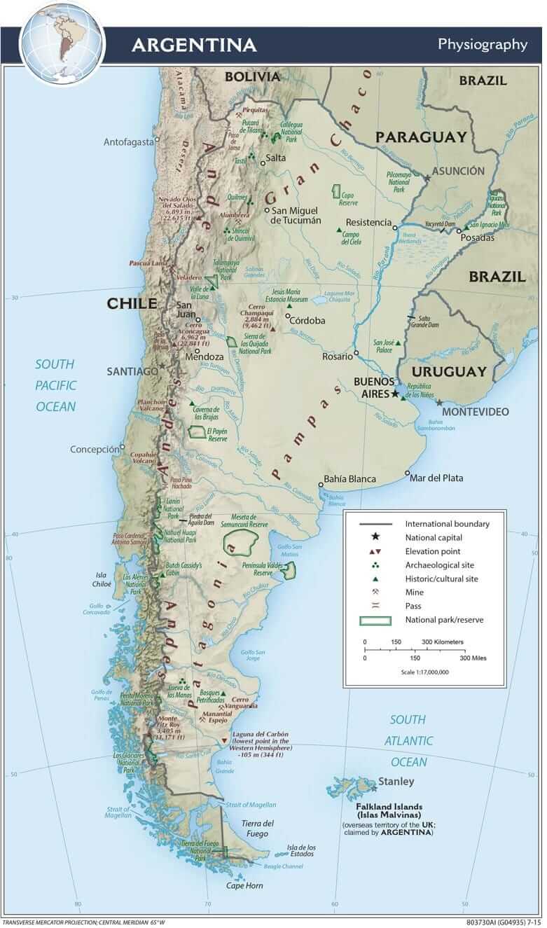
Physiographic map of Argentina.
The Andean Cordillera: Western Rampart
The Andes Mountains form Argentina's western spine, creating a formidable natural boundary with Chile that extends for over 3,500 kilometers (2,175 miles). This massive mountain system, part of the world's longest continental mountain range, spans 8,900 kilometers (5,530 miles) from Venezuela to Tierra del Fuego, exhibiting distinct characteristics as it traverses Argentina from north to south.
In the northwestern provinces of Jujuy and Salta, the Andes present themselves as a high, arid plateau known as the Puna. Here, elevations commonly exceed 3,500 meters (11,483 feet), with some areas reaching over 4,500 meters (14,764 feet), creating a harsh environment characterized by extreme temperature fluctuations ranging from 25°C (77°F) during the day to -20°C (-4°F) at night, intense solar radiation due to thin atmospheric conditions, and sparse precipitation averaging less than 200 millimeters (8 inches) annually. The landscape is dominated by salt flats (salars), including the famous Salinas Grandes, which cover an area of 212 square kilometers (82 square miles). It also features volcanic peaks, such as Llullaillaco at 6,739 meters (22,110 feet), and mineral-rich deposits that have been exploited since pre-Columbian times.
The Puna's unique ecosystem supports specialized flora and fauna adapted to high-altitude desert conditions. Vicuñas, the wild ancestors of domesticated alpacas, graze on sparse bunch grasses, while flamingos feed in alkaline lakes rich in microscopic organisms. The region's extreme conditions have created endemic plant species, including the yareta (Azorella compacta), a compact cushion plant that can live over 3,000 years.
Moving southward, the central Andes transition into a more temperate zone encompassing the Cuyo region. This area, including the provinces of Mendoza, San Juan, and San Luis, benefits from the orographic effect of the mountains, which creates favorable conditions for agriculture in the valley floors at elevations between 500 and 1,500 meters (1,640 and 4,921 feet). The region's most notable feature is Aconcagua, standing at 6,961 meters (22,837 feet) as the highest peak in both hemispheres outside of Asia and the tallest mountain in the Americas.
The central Andes region supports Argentina's most important wine-producing areas, with vineyards extending up to 1,500 meters (4,921 feet) in elevation. The combination of high altitude, intense sunlight, and dramatic diurnal temperature variations creates ideal conditions for producing world-class wines, particularly Malbec varieties that have become synonymous with Argentine viticulture.
The southern Andes, extending into Patagonia, undergo a dramatic transformation from the dry peaks of the north into a landscape of glaciers, temperate rainforests, and pristine lakes. This region boasts some of South America's most spectacular scenery, including the Southern Patagonian Ice Field, which spans approximately 13,000 square kilometers (5,019 square miles) and represents the world's third-largest ice mass, after Antarctica and Greenland.
The Patagonian Andes experience significantly higher precipitation due to their exposure to moisture-laden westerly winds from the Pacific Ocean. Annual rainfall on the western slopes can exceed 3,000 millimeters (118 inches), supporting dense temperate rainforests of southern beech (Nothofagus) and other endemic species, which contrasts sharply with the eastern slopes, which receive less than 300 millimeters (12 inches) annually due to the rain shadow effect.
The Pampas: Argentina's Economic Foundation
The Pampas region represents Argentina's geographical and economic heart, covering approximately 750,000 square kilometers (289,575 square miles) of fertile plains that extend from the Atlantic coast to the foothills of the Andes. This vast grassland, characterized by its remarkably flat topography with elevation changes rarely exceeding 200 meters (656 feet) and deep, nutrient-rich soils reaching depths of 2-3 meters (6.5-10 feet), has earned Argentina its reputation as one of the world's leading agricultural producers.
The geological formation of the Pampas resulted from millions of years of sediment deposition carried by rivers from the Andes and Brazilian highlands, creating some of the most fertile soils on Earth. These mollisols, characterized by their dark color and high organic matter content, contain exceptional levels of phosphorus, nitrogen, and other nutrients essential for plant growth. The region's humid subtropical climate, with annual rainfall ranging from 600 to 1,200 millimeters (24 to 47 inches), provides ideal conditions for both crop cultivation and livestock grazing.
The natural grasslands that once covered this region supported vast herds of wild animals and later became the foundation for Argentina's cattle industry. Today, the Pampas produces over 95% of Argentina's wheat, corn, soybeans, and beef, making it one of the world's most productive agricultural regions. The area's agricultural output is equivalent to feeding approximately 400 million people annually.
The Pampas can be subdivided into several distinct zones: the Humid Pampas, which includes the most productive agricultural areas around Buenos Aires and extends into parts of Santa Fe, Córdoba, and Entre Ríos, receiving 800-1,200 millimeters (31-47 inches) of annual rainfall; the Dry Pampas, characterized by lower rainfall of 400-600 millimeters (16-24 inches) and more extensive livestock operations; and the Mesopotámico Pampas, which transitions into the wetland systems of the Paraná River delta.
The region's infrastructure development has been crucial to its agricultural success. The Pampas contains Argentina's densest transportation network, with over 200,000 kilometers (124,274 miles) of roads and 36,000 kilometers (22,369 miles) of railways connecting rural areas to major ports. The Port of Buenos Aires alone handles over 70% of Argentina's agricultural exports, underscoring the region's pivotal role in the national economy.
Patagonia: The Land of Fire and Ice
Argentine Patagonia, occupying the southern third of Argentina's territory, represents one of the world's last great wilderness frontiers. This vast region, covering over 787,000 square kilometers (303,861 square miles) – larger than Texas – is characterized by its extreme geographical diversity, ranging from arid steppes to glacial landscapes, from windswept plateaus reaching elevations of 2,000 meters (6,562 feet) to protected fjords cutting deep into the continental shelf.
The region's climate is dominated by the westerly winds, known locally as the "Roaring Forties" and "Furious Fifties," which bring moisture from the Pacific Ocean that the Andes largely blocks. These winds can reach velocities of over 100 kilometers per hour (62 mph) and blow consistently for months, creating a dramatic east-west precipitation gradient. The western slopes receive abundant rainfall that supports temperate rainforests, while the eastern plains remain arid and support only sparse vegetation adapted to receiving less than 200 millimeters (8 inches) of annual precipitation.
Patagonia's geological history is written in its landscape, with evidence of glacial activity, volcanic eruptions, and tectonic forces visible throughout the region. The Patagonian ice fields, remnants of the last ice age that covered much of the area 18,000 years ago, continue to shape the landscape through glacial advance and retreat. These ice masses, including the Upsala Glacier, which spans 870 square kilometers (336 square miles), feed numerous glacial lakes, such as Lago Argentino, covering 1,466 square kilometers (566 square miles), and Lago Viedma, spanning 1,088 square kilometers (420 square miles), which display the characteristic turquoise color of glacial meltwater rich in finely ground rock particles.
The region's biodiversity is unique, with numerous endemic species that have adapted to the harsh conditions. The Valdés Peninsula, a UNESCO World Heritage Site covering 3,625 square kilometers (1,400 square miles), serves as a crucial breeding ground for marine mammals, including southern right whales, elephant seals weighing up to 4,000 kilograms (8,818 pounds), and sea lions. The peninsula's coastal waters support one of the world's largest populations of southern right whales, with over 2,000 individuals visiting annually.
The Patagonian steppe supports guanacos, South America's largest wild ungulate, with populations exceeding 500,000 individuals. These animals, along with rheas (South America's largest bird), armadillos, and numerous smaller species, have adapted to the region's extreme conditions through specialized physiological and behavioral adaptations.
Patagonia's mineral wealth includes significant deposits of oil and natural gas, particularly in the Neuquén Basin, which produces over 50% of Argentina's petroleum. The region also contains substantial coal deposits and emerging lithium reserves that are becoming increasingly important for global battery production.
Mesopotamia: The Land Between Rivers
Argentina's northeastern region, known as Mesopotamia, is defined by its position between the Paraná and Uruguay rivers. This area, encompassing the provinces of Misiones, Corrientes, and Entre Ríos across 196,781 square kilometers (75,978 square miles), represents Argentina's wettest region and serves as a crucial component of the broader Río de la Plata basin, which drains approximately 3.2 million square kilometers (1.2 million square miles) of South America.
The region's subtropical climate, with temperatures ranging from 15°C (59°F) in winter to 27°C (81°F) in summer, and abundant water resources, which receive 1,200-2,000 millimeters (47-79 inches) of annual rainfall, support lush vegetation and diverse ecosystems. The Misiones province, in particular, contains remnants of the Atlantic Forest (Mata Atlántica), one of the world's most endangered biomes that originally covered 1.5 million square kilometers (579,153 square miles) but has been reduced to less than 12% of its original extent.
This forest ecosystem supports extraordinary biodiversity, with over 2,000 plant species, 450 bird species, and numerous mammals, including jaguars, pumas, ocelots, and howler monkeys. The region's endemic species include the Misiones tree frog and several butterfly species found nowhere else on Earth.
The Iguazú Falls, situated on the border between Argentina and Brazil, represent one of the world's most spectacular natural wonders. These falls, formed by the Iguazú River as it plunges 82 meters (269 feet) into the Paraná River valley, create a series of 275 individual cascades that stretch nearly 3 kilometers (1.9 miles) across, surrounded by pristine subtropical rainforest that harbors exceptional biodiversity. The falls discharge an average of 1,756 cubic meters (62,010 cubic feet) of water per second, with peak flows reaching over 13,000 cubic meters (459,000 cubic feet) per second during flood conditions.
The Mesopotamian region's river systems support important commercial fisheries, featuring over 200 freshwater fish species, including the massive surubí catfish, which can reach lengths of 1.5 meters (5 feet) and weights exceeding 60 kilograms (132 pounds). The region's extensive wetlands, including the Iberá Wetlands, which cover 13,000 square kilometers (5,019 square miles), serve as a crucial habitat for waterfowl and other aquatic species.
The Gran Chaco: Argentina's Forgotten Wilderness
The Gran Chaco, spanning northern Argentina, Paraguay, Bolivia, and Brazil, is one of South America's largest and most threatened ecosystems. This vast lowland plain, covering approximately 647,500 square kilometers (250,000 square miles) within Argentina – an area larger than France – is characterized by its hot, semi-arid climate with summer temperatures frequently exceeding 45°C (113°F) and diverse vegetation patterns ranging from dense forests to open savannas.
The region's landscape varies dramatically across its extent, from dry forests dominated by quebracho trees (Schinopsis balansae) that can live over 400 years and reach heights of 25 meters (82 feet), to scrublands adapted to seasonal drought, to seasonal wetlands that flood during the austral summer, and palm savannas featuring the distinctive caranday palm (Copernicia alba).
Despite its harsh conditions, the Gran Chaco supports remarkable biodiversity, including jaguars, pumas, giant anteaters weighing up to 65 kilograms (143 pounds), tapirs, and over 500 bird species. The region is home to over 3,400 plant species, including numerous medicinal plants that Indigenous communities have used for centuries. The Chaco is home to approximately 30 Indigenous groups, including the Wichí, Toba, and Pilagá peoples, who have developed sophisticated systems for managing these resources sustainably.
The region's wildlife includes some of South America's most endangered species, such as the Chacoan peccary, which was only discovered by science in 1975 and is now estimated to number fewer than 3,000 individuals. The Gran Chaco also supports important populations of giant otters, jaguarundis, and over 100 reptile species, including the broad-snouted caiman.
However, the Gran Chaco faces severe environmental pressures from agricultural expansion, particularly the cultivation of soybeans and cattle ranching. Between 2000 and 2020, the region lost over 5.4 million hectares (13.3 million acres) of forest cover, resulting in deforestation rates among the highest in the world, which threatens both biodiversity and the livelihoods of Indigenous communities that depend on forest resources for their survival.
Coastal Geography and Marine Environments
Argentina's Atlantic coastline extends for over 4,989 kilometers (3,100 miles), from the Río de la Plata estuary in the north to the Beagle Channel in the south. This extensive coastline encompasses a diverse range of environments, including estuaries, sandy beaches that extend for hundreds of kilometers, rocky cliffs rising to 200 meters (656 feet) above sea level, and protected bays that serve as natural harbors.
The Río de la Plata estuary, formed by the convergence of the Paraná and Uruguay rivers, represents one of the world's largest estuarine systems, covering approximately 35,000 square kilometers (13,514 square miles). This muddy, nutrient-rich waterway, with maximum widths reaching 220 kilometers (137 miles), supports important fisheries and serves as a crucial corridor for international trade through the ports of Buenos Aires and Montevideo. The estuary's freshwater influence extends up to 200 kilometers (124 miles) into the Atlantic Ocean, creating unique brackish conditions that support specialized ecosystems.
Argentina's marine ecosystems are among the most productive in the world, supported by the convergence of the warm Brazil Current, flowing southward along the coast, and the cold Malvinas (Falkland) Current, flowing northward. This convergence creates upwelling zones that bring nutrient-rich deep waters to the surface, supporting exceptional marine productivity. These waters support a diverse array of marine life, including southern right whales with a population of approximately 4,000 individuals, elephant seals, leopard seals, and numerous fish species that form the backbone of Argentina's fishing industry.
The Patagonian Shelf, extending up to 850 kilometers (528 miles) from the coast, represents one of the world's most productive fishing grounds, supporting commercial fisheries for hake, anchovy, squid, and shrimp. The region's annual fish catch exceeds 800,000 tons, making Argentina one of the world's top fishing nations.
Argentina's marine protected areas include the Valdés Peninsula Marine Protected Area and the recently established Yaganes Marine Park, which covers 68,834 square kilometers (26,576 square miles) in the Beagle Channel, protecting crucial habitats for marine mammals, seabirds, and kelp forests.
Climate Patterns and Regional Variations
Argentina's climate diversity results from its vast latitudinal extent of 33 degrees, varied topography with elevation differences exceeding 7,000 meters (22,966 feet), and the influence of different air masses, including tropical maritime air from the Atlantic, continental tropical air from the interior, and polar maritime air from the south. The country experiences climates ranging from tropical in the north, with annual average temperatures of 23°C (73°F), to subantarctic in the south, with averages of 6°C (43°F). There are significant variations between the eastern and western regions due to the orographic effects of the Andes.
The north experiences a subtropical climate with distinct wet and dry seasons, receiving 80% of annual precipitation between November and March. Summer temperatures can exceed 40°C (104°F) in the Gran Chaco, while winter temperatures rarely drop below freezing except at high elevations.
The Pampas enjoys a temperate climate with relatively even precipitation distribution throughout the year, though with a slight summer maximum. The region's moderate temperatures, ranging from 8°C (46°F) in winter to 23°C (73°F) in summer, combined with adequate moisture, create ideal conditions for agriculture.
Strong westerly winds, low precipitation on the eastern slopes, and significant temperature variations between seasons characterize the climate of Patagonia. The region experiences the strongest winds in Argentina, with some areas recording gusts exceeding 200 kilometers per hour (124 mph). Winter temperatures can drop to -20°C (-4°F) in the interior, while summer temperatures rarely exceed 25°C (77°F).
Climate change poses significant challenges for Argentina's diverse ecosystems and agricultural systems. Rising temperatures, with increases of 0.5-1.0°C (0.9-1.8°F) recorded since 1960, changing precipitation patterns, and increased frequency of extreme weather events threaten both natural ecosystems and human activities across the country. Glacial retreat in the Andes has accelerated, with some glaciers losing over 20% of their area since 1945.
Human Geography and Settlement Patterns
Argentina's physical geography has profoundly influenced human settlement patterns and economic development. The majority of the country's 45 million inhabitants live in the Pampas region, with Greater Buenos Aires alone housing over 13 million people – nearly 30% of the national population concentrated in less than 1% of the territory. This massive urban concentration reflects the region's economic importance and favorable climate conditions.
Population density varies dramatically across the country, from over 2,400 people per square kilometer (6,216 per square mile) in the capital district to less than one person per square kilometer (2.6 per square mile) in much of Patagonia. The Andes support scattered settlements in valleys and mining centers, typically at elevations between 500 and 3,000 meters (1,640 and 9,843 feet), with populations adapted to high-altitude conditions.
Urban development patterns reflect geographical constraints and opportunities. Coastal cities, such as Mar del Plata, with over 600,000 inhabitants, developed as ports and resort destinations, while interior cities like Córdoba and Rosario grew as agricultural and industrial centers. In Patagonia, cities such as Bariloche and Ushuaia have developed primarily as tourist destinations and regional service centers.
The distribution of Argentina's Indigenous population, comprising approximately 2.4% of the national total, closely reflects historical geographical patterns. The highest concentrations are found in the northwest (among the Quechua and Aymara peoples), the northeast (among the Guaraní groups), and Patagonia (among the Mapuche and Tehuelche peoples), each adapted to its specific geographical environment.
Environmental Challenges and Conservation
Argentina faces significant environmental challenges related to its geographical diversity. These include deforestation in the Gran Chaco and Mesopotamia, with annual forest loss exceeding 300,000 hectares (741,316 acres), soil degradation in the Pampas affecting over 60% of agricultural land, glacial retreat in the Andes with ice loss rates of 0.5-1.0% annually, and marine pollution along the coast from urban and industrial sources.
Soil erosion in the Pampas, accelerated by intensive agriculture and inadequate conservation practices, results in the loss of 200-300 million tons of topsoil annually. This erosion not only reduces agricultural productivity but also contributes to sedimentation in river systems and coastal waters.
Climate change exacerbates many of these challenges, with projections indicating temperature increases of 1.5-3.0°C (2.7-5.4°F) by 2100 and significant changes in precipitation patterns. These changes threaten both natural ecosystems and agricultural productivity, requiring comprehensive adaptation strategies.
The country has established numerous protected areas, including 47 national parks covering 4.2 million hectares (10.4 million acres), as well as provincial parks and biosphere reserves, to preserve its diverse ecosystems. However, protected areas represent only 6.8% of Argentina's territory, which is below the international target of 17% for terrestrial environments.
Balancing conservation with economic development remains a significant challenge, particularly in regions rich in natural resources. The development of shale oil and gas reserves in Patagonia, the expansion of mining operations in the Andes, and agricultural intensification in the Pampas all create tensions between economic growth and environmental protection.
Conclusion
Argentina's geography represents a remarkable synthesis of natural forces that have created one of the world's most diverse and resource-rich nations. From the towering peaks of the Andes to the fertile plains of the Pampas, from the wilderness of Patagonia to the wetlands of Mesopotamia, each region makes a unique contribution to Argentina's national character and global significance.
The country's geographical assets include some of the world's most fertile agricultural land, extensive mineral resources, abundant freshwater reserves, vast renewable energy potential, and extraordinary biodiversity. These resources provide the foundation for Argentina's role as a major food exporter, emerging energy producer, and guardian of globally significant ecosystems.
Understanding Argentina's geography is essential for appreciating not only its natural beauty but also its economic potential, cultural diversity, and environmental challenges. The country's geographical diversity has shaped its history, from pre-Columbian civilizations adapted to specific environments to Spanish colonial settlement patterns that favored certain regions over others.
As Argentina continues to develop in the 21st century, the sustainable management of its geographical heritage will be crucial for ensuring prosperity for future generations while preserving the natural wonders that make Argentina truly unique among the world's nations. The challenge lies in harnessing the country's geographical advantages while addressing the environmental pressures that threaten its natural heritage.
The geographical diversity that defines Argentina also represents its greatest opportunity and responsibility. By embracing sustainable development practices that respect the integrity of its diverse ecosystems, Argentina can continue to benefit from its natural wealth while contributing to global environmental conservation efforts. The future of this remarkable nation depends on successfully balancing human needs with the preservation of its extraordinary geographical heritage, which makes Argentina one of the world's most fascinating and important countries.
Argentina's geographical legacy extends beyond its borders, influencing global food security, climate regulation, and biodiversity conservation. The country's role as a steward of the world's second-largest freshwater aquifer, the Guaraní Aquifer, its position as a major carbon sink through its forests and grasslands, and its responsibility for protecting globally significant wildlife populations make Argentina's geographical management a matter of international importance.
The integration of traditional knowledge from Indigenous communities with modern scientific understanding offers pathways for sustainable resource management that honor both cultural heritage and ecological integrity. This approach recognizes that Argentina's geographical diversity is not merely a collection of natural resources but a complex system of interconnected environments that have supported human communities for millennia and must continue to do so for generations to come.