Serra do Mar: Brazil's Emerald Escarpment
The Serra do Mar stands as a grand testament to Brazil's geological marvels and ecological richness. Stretching along the southeastern coastline, this expansive system of coastal mountain ranges and escarpments weaves its way from Espírito Santo in the north to Río Grande do Sul in the south.

 via Wikimedia Commons")
 via Wikimedia Commons")
 peak in the background, Serra dos Órgãos National Park, Brazil - by Carlos Perez Couto - Own work, (CC BY-SA 3.0) via Wikimedia Commons")
 via Wikimedia Commons")

Guardians of the Mist: Exploring the Serra do Mar Mountain System
Along Brazil's southeastern Atlantic coast, where the azure ocean meets the verdant mountains, rises one of South America's most spectacular geological formations. The Serra do Mar, whose name translates poetically as "Mountain Range of the Sea," stretches for approximately 1,500 kilometers (930 miles), forming a dramatic backdrop that has shaped both the landscape and the destiny of Brazil. From the misty highlands of Espírito Santo in the north to the rugged coastlines of Santa Catarina in the south, this ancient mountain system forms an almost continuous barrier between Brazil's interior plateau and the Atlantic Ocean. Here, where tropical forests cling to impossibly steep slopes and waterfalls plunge from cloud-shrouded peaks into emerald valleys below, nature has created one of the world's most biodiverse and visually stunning landscapes—a living monument to the power of geological time and the resilience of life itself.
A Geological Masterpiece Carved by Time
The Serra do Mar emerges breathtakingly from the Atlantic coastal plains, its ancient peaks ascending abruptly from sea level to heights exceeding 2,000 meters (6,562 feet). This magnificent escarpment represents one of Earth's most dramatic geological transitions, where the Brazilian Highlands plunge toward the ocean in a series of precipitous cliffs, deep valleys, and mist-shrouded peaks that seem to touch the clouds themselves.
Geologically, this mountain system is part of the crystalline basement of eastern South America, its foundations laid down during the Precambrian era and sculpted over millions of years. Despite its imposing and seemingly volatile appearance, the Serra do Mar rests on remarkably stable tectonic foundations, with most of its current elevations forming approximately 60 million years ago during the Paleogene period. This ancient stability has allowed for the development of one of the world's most complex and biodiverse ecosystems.
The range encompasses numerous distinct mountain systems, each contributing its own character to the greater whole. The Serra da Bocaina guards the border between São Paulo and Rio de Janeiro with its pristine forests and rushing waterfalls. The famous Serra dos Órgãos captivates visitors with its organ-pipe rock formations that pierce the sky like Gothic cathedral spires, while the Serra de Paranapiacaba features some of the most dramatic escarpments in the entire system, with its steep faces cloaked in perpetual mists that nourish the cloud forests clinging to its slopes. Further south, the Serra Geral continues the coastal ramparts with its basaltic plateaus and deep canyons carved by ancient rivers.
A Living Laboratory of Biodiversity
Within the folds and valleys of the Serra do Mar lies one of the planet's most extraordinary biological treasures. The mountain range serves as the backbone of the Atlantic Forest biome, known scientifically as the Mata Atlântica, which has been recognized as one of the world's most important biodiversity hotspots. This ecosystem encompasses the Serra do Mar coastal forests ecoregion, a distinct ecological zone characterized by its montane forests and unique assemblages of endemic species. Though reduced to mere fragments of its original extent, this ecoregion still harbors an astounding array of life forms found nowhere else on Earth.
The forests that cascade down the mountain slopes represent a complex mosaic of ecological communities. In the montane zones, families such as Bromeliaceae, Myrtaceae, Melastomataceae, and Lauraceae dominate the canopy, creating multi-layered habitats that support an intricate web of life. Epiphytic bromeliads (Bromelia spp.) create aerial gardens in the forest canopy, while towering trees of the myrtle family (Myrtaceae) provide structural support for this vertical ecosystem. The understory blooms with the vibrant flowers of Melastomataceae species, their purple and pink petals adding splashes of color to the forest floor's perpetual twilight.
The fauna of the Serra do Mar reads like a catalog of South American natural wonders. Jaguars (Panthera onca) prowl the deepest forest recesses, their spotted coats blending seamlessly with the dappled sunlight. South American tapirs (Tapirus terrestris) lumber through the undergrowth; these gentle giants serve as gardeners of the forest through their seed dispersal. Overhead, the brilliant plumage of toucans (Ramphastos spp.) flashes through the canopy, while the haunting calls of howler monkeys (Alouatta spp.) echo across the valleys at dawn and dusk.
The region supports approximately 350 bird species, many of which are found nowhere else in the world. Golden lion tamarins (Leontopithecus rosalia) leap through the trees with their magnificent manes catching the filtered sunlight, while countless species of orchids (Orchidaceae) bloom in ethereal beauty throughout the forest layers. This remarkable biodiversity represents not just a collection of species, but a functioning ecosystem where each organism plays a crucial role in maintaining the delicate balance of life.
Guardians of the Green Cathedral
Recognizing the irreplaceable value of this natural heritage, Brazil has established an extensive network of protected areas throughout the Serra do Mar. The crown jewel of these conservation efforts is the Serra do Mar State Park, which encompasses 332,000 hectares (820,000 acres) across 25 municipalities in São Paulo state. Created in 1977 and expanded in 2010, this park represents the largest continuous protected area of Atlantic Forest in Brazil, serving as a vital refuge for countless threatened species.
The park forms part of the larger Bocaina Mosaic, established in 2006 as a comprehensive conservation strategy covering 221,754 hectares (547,970 acres). This innovative approach recognizes that effective conservation requires landscape-scale planning that connects fragmented habitats and allows for species movement across the broader ecosystem. The Serra do Mar Ecological Corridor extends this vision even further, encompassing approximately 12.6 million hectares (31.1 million acres) across the states of Rio de Janeiro, Minas Gerais, São Paulo, and Paraná.
These protected areas face the constant challenge of existing within one of Brazil's most densely populated regions. The corridor must thread its way between major cities, industrial zones, and agricultural areas, making its preservation a complex balancing act between conservation needs and human development pressures. Yet these green islands serve as lungs for the surrounding urban areas, regulating climate, purifying water, and providing essential ecosystem services to millions of people.
Living Heritage and Cultural Tapestry
The Serra do Mar's significance extends far beyond its biological treasures to encompass a rich cultural heritage that spans centuries. Within the protected areas and surrounding regions live traditional communities whose lives have been intertwined with the forest for generations. Quilombola communities, descendants of enslaved Africans who escaped captivity, have developed sustainable ways of life that coexist harmoniously with the forest ecosystem. Indigenous peoples maintain their ancestral connections to the land, while caiçara communities along the coast have evolved unique cultural practices that bridge marine and terrestrial environments.
These communities serve as living repositories of traditional ecological knowledge, understanding the forest's rhythms and patterns in ways that complement scientific conservation efforts. Their presence reminds us that the Serra do Mar is not merely a pristine wilderness but a cultural landscape where humans and nature have coevolved for centuries.
Historically, the Serra do Mar served as a formidable natural fortress that shaped Brazil's development patterns. Early Portuguese colonizers found the steep escarpments nearly impassable, resulting in the concentration of settlements along the coast, while the interior remained largely unexplored for centuries. The mountain range effectively created two Brazils: the coastal zone, connected to Europe and the Atlantic world, and the vast interior, which would later be opened through various routes and influences.
The construction of railways in the 19th century represented a triumph of engineering over geography, finally providing reliable passages through the mountain barrier. These railways, including the famous Santos-Jundiaí line with its dramatic inclined planes, opened the interior to coffee cultivation and forever changed Brazil's economic geography. Today, modern highways snake through mountain passes, but the Serra do Mar continues to influence transportation patterns and urban development throughout southeastern Brazil.
Challenges and Future Horizons
As Brazil moves deeper into the 21st century, the Serra do Mar faces unprecedented challenges. Urban expansion from the São Paulo metropolitan region and coastal cities creates constant pressure on protected areas. Climate change brings new uncertainties, with shifting precipitation patterns and rising temperatures potentially altering the delicate conditions that support the Atlantic Forest's unique communities.
Yet hope persists in the form of innovative conservation strategies, growing environmental awareness, and the resilience of the ecosystem itself. Scientific research continues to reveal new species and ecological relationships, while restoration projects work to reconnect fragmented habitats. The Serra do Mar stands as both a monument to Earth's creative power and a testament to Brazil's commitment to preserving its natural heritage.
In the early morning hours, when mist rises from the valleys, and the first light of dawn illuminates the forest canopy, the Serra do Mar reveals its timeless beauty. Here, in this vertical world where every elevation harbors different forms of life, where waterfalls cascade from impossible heights, and where the green cathedral of the Atlantic Forest reaches toward the sky, we find one of our planet's most precious treasures. The Serra do Mar reminds us that some things transcend human timescales, that beauty and biodiversity represent values beyond economic calculation, and that our responsibility as stewards of this Earth extends far beyond our own brief moment in geological time.
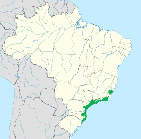
Map depicting the approximate location of the Serra do Mar coastal range.