Cabo de Hornos National Park: The Southernmost Wilderness of Chile
Cabo de Hornos National Park is the southernmost national park in the world. Nestled in the remote Wollaston Archipelago within the Hermite Islands complex, it is characterized by its unique geographical features, extreme weather, diverse flora and fauna, and role in global conservation efforts.
 - via Wikimedia Commons")
, Chile - via Wikimedia Commons")
, the Hermite Islands (center), and Cape Horn (lower right)")
Exploring the Edge of the Earth: Cabo de Hornos National Park
Cabo de Hornos National Park, established in 1945 by the Chilean Ministry of Agriculture, stands as the southernmost national park in the world, except for the disputed Chilean Antarctic Territory. Nestled in the remote Wollaston Archipelago within the Hermite Islands complex, this park forms part of the core area of the Cabo de Hornos Biosphere Reserve alongside Alberto de Agostini National Park. Covering an area of 63,093 hectares (155,900 acres), Cabo de Hornos National Park is a testament to the pristine and rugged beauty of southern Chile's wilderness. The park is characterized by its unique geographical features, extreme weather conditions, diverse flora and fauna, and its significant role in global conservation efforts.
Geographic and Climatic Overview
Location and Landscape
Cabo de Hornos National Park is located in the Commune of Cabo de Hornos in the Antártica Chilena Province of the Magallanes y Antártica Chilena Region. The park's general altitude is 220 meters (720 feet), with notable peaks including Cerro Pirámide at 406 meters (1,330 feet) and Cerro Hyde, the highest point, at 670 meters (2,200 feet). The park is 12 hours by boat from Puerto Williams, situated at the southernmost headland of Tierra del Fuego. This geographical position makes Cabo de Hornos the only place in the world where the waters of the Pacific and Atlantic Oceans converge.
Climate
The climate in Cabo de Hornos National Park is generally cool, with high precipitation throughout the year due to its southern latitude. The nearby Diego Ramirez Islands, located 109 kilometers (68 miles) southwest in the Drake Passage, record the highest rainfall in March, averaging 137.4 millimeters (5.4 inches), and the least precipitation in October, averaging 93.7 millimeters (3.7 inches). Severe wind conditions, especially in winter, characterize the park's harsh weather. These extreme conditions create a challenging yet fascinating environment for the park's inhabitants and visitors.
The Route of Parks
Cabo de Hornos National Park is essential to Chile's scenic 2,800-kilometer (1,700-mile) "Route of Parks," stretching from Puerto Montt in the north to Cape Horn in the south. This route connects 17 national parks, covering one-third of Chile and protecting over 11.8 million hectares (28 million acres). The Route of Parks promotes conservation, sustainable tourism, and the appreciation of Chile's diverse and breathtaking landscapes. It represents a significant effort to protect the country's natural heritage while providing opportunities for ecotourism and education.
Flora and Fauna
Vegetation
The Cape Horn Archipelago hosts the world's southernmost forested ecosystem and protects five percent of the world's bryophyte diversity. The terrain is predominantly treeless peat, characterized by tuberous vegetable formations covered in low-dense Poaceae (Gramineae), lichen, and mosses adapted to low temperatures and harsh weather conditions. In some areas, small wooded regions of Antarctic beech, lenga, winter's bark (canelo), and Magellanic coigüe make up the southernmost forest on earth, offering a unique glimpse into a fragile and resilient ecosystem.
Wildlife
The fauna in Cabo de Hornos National Park is relatively scarce, with many species endangered. Birds and marine mammals dominate the park's wildlife. Notable bird species include the Magellanic penguin (Spheniscus magellanicus), southern giant petrel (Macronectes giganteus), kelp gull (Larus dominicanus), red-legged cormorant (Phalacrocorax gaimardi), and southern royal albatross (Diomedea epomophora). These birds play a critical role in the park's ecosystem, contributing to its biodiversity and ecological balance.
Marine mammals in the park include the marine otter (Lontra felina), leopard seal (Hydrurga leptonyx), Chilean dolphin (Cephalorhynchus eutropia), Burmeister's porpoise (Phocoena spinipinnis), Peale's dolphin (Lagenorhynchus australis), and humpback whale (Megaptera novaeangliae). These species highlight the park's importance as a sanctuary for marine biodiversity and the need for ongoing conservation efforts. The presence of these mammals underscores the park's role in protecting marine life and maintaining healthy ocean ecosystems.
Conservation and Scientific Significance
As part of the Cabo de Hornos Biosphere Reserve, Cabo de Hornos National Park plays a critical role in global conservation efforts. The park's unique ecosystems and biodiversity make it a valuable area for scientific research, particularly in studying the impacts of climate change on fragile environments. The park's remote location and harsh weather conditions offer a natural laboratory for scientists to observe and analyze ecological processes in extreme conditions.
Research in Cabo de Hornos focuses on various areas, including management practices, geology, glaciology, and the inventory of flora and fauna. The park provides an ideal setting for studying vegetation succession and the ecology of animals of particular interest. By prioritizing scientific research and conservation, Cabo de Hornos National Park contributes to our understanding of global ecological dynamics and the effects of environmental changes.
Conclusion
Cabo de Hornos National Park represents the ultimate frontier of natural conservation in Chile. Its remote location, diverse ecosystems, and unique biodiversity make it a critical preservation and scientific research area. As part of the Route of Parks, the park contributes to Chile's comprehensive conservation strategy, promoting sustainable tourism and protecting the natural heritage of Patagonia. Cabo de Hornos National Park stands as a symbol of southern Chile's rugged beauty and ecological significance of southern Chile, offering a glimpse into one of the most remote and pristine wilderness areas on earth.
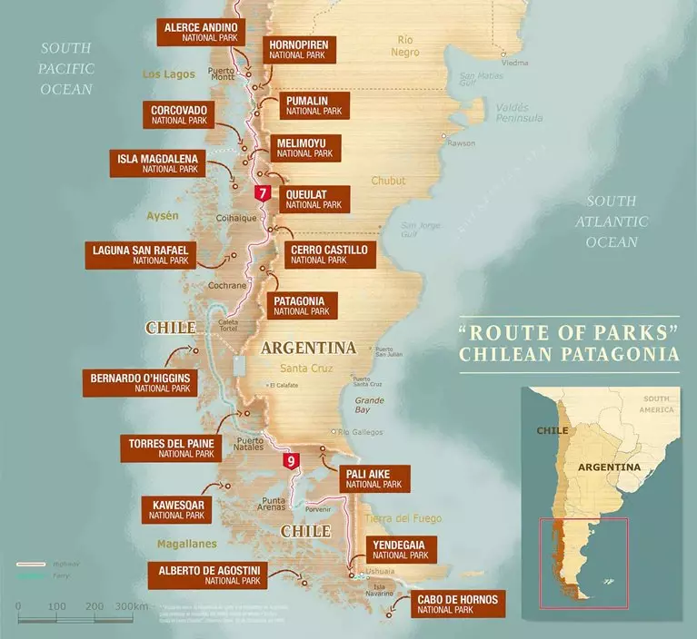
Chile's Route of Parks map - Thompson Conservation