Torres del Paine: A Breathtaking Journey Through Patagonia's Iconic Wilderness
Deep within Chilean Patagonia, where the Andes converge with the Patagonian Steppe, lies a realm of unparalleled natural beauty – Torres del Paine National Park. The Cordillera del Paine stands at its core, a majestic mountain range that rises sharply above the surrounding terrain.


Unraveling the Majesty of Torres del Paine National Park
Deep within the heart of Chilean Patagonia, where the mighty Andes Mountains converge with the vast Patagonian Steppe, lies a realm of unparalleled natural beauty – Torres del Paine National Park. This breathtaking expanse of rugged peaks, glaciers, lakes, and rivers is undoubtedly one of the world's most iconic wilderness areas, drawing adventurers and nature enthusiasts from across the globe. At its core stands the Cordillera del Paine, a majestic mountain range that rises sharply above the surrounding terrain, its granite spires and towering pinnacles capturing the imagination of all who behold them.
The Cordillera del Paine: A Geological Masterpiece
Carved by Glaciers, Shaped by Time
The Cordillera del Paine is an extension of the main range of the Southern Patagonian Andes, located north of the city of Punta Arenas. Its name, derived from the native Tehuelche language, translates to "blue," a fitting tribute to the azure hues that often grace its towering peaks. This imposing mountain range is the backbone of Patagonia, rising sharply above the eastern foreland basin and dissected into several distinct mountain groups.
At the heart of the Cordillera del Paine lies the Paine Grande, the highest point of the range and a testament to the region's glacial past. The most prominent peaks, however, are the iconic Cuernos del Paine (Paine's Horns), separated from the Paine Grande by the deep glacial Vallé Francés.
Torres del Paine: Nature's Towering Cathedrals
The Iconic Granite Spires that Define Patagonia
Nestled within the heart of the Cordillera del Paine is the Torres del Paine, the distinctive three granite peaks that have become synonymous with the region's rugged beauty. These towering spires, alongside the equally impressive Cerro Torre and Monte Fitz Roy, dominate the landscapes with their pronounced shapes, capturing the imagination of climbers and photographers alike.
The Torres del Paine and the Cuernos del Paine form the central part of the Paine massif, a spur of the Andes that rises dramatically above the Patagonian steppe. Small valleys separate these spectacular granite spires and mountains, each with a unique character – the Valle del Francés (French Valley), Valle Bader, Valle Ascencio, and Valle del Silencio (Silence Valley).
Torres del Paine National Park: A Sanctuary of Natural Wonders
Preserving Patagonia's Pristine Wilderness
The Chilean government established Torres del Paine National Park to protect the incredible natural wonders of the Cordillera del Paine and its surrounding landscapes. This vast protected area encompasses southern Chilean Patagonia's mountains, glaciers, lakes, and rivers, transitioning between the Magellanic subpolar forests and the Patagonian Steppe.
Within the park's boundaries lie some of the region's most iconic glaciers, including the Dickson, Grey, and Tyndall glaciers, as well as numerous vividly colored lakes, such as Dickson Lake, Nordenskjöld Lake, Lake Pehoé, Grey Lake, Sarmiento Lake, and Del Toro Lake. The main river flowing through the park is the Paine River, though most rivers and lakes drain into Última Esperanza Sound via the Serrano River.
A Tapestry of Ecosystems and Biodiversity
From Patagonian Steppe to Andean Deserts
Torres del Paine National Park and the surrounding Torres del Paine Biosphere Reserve encompass a remarkable diversity of ecosystems, each harboring a unique array of flora and fauna. Within the Biosphere Reserve, four distinct ecological zones coexist, each adapted to the region's unique climate and topography.
The Pre-Andean Scrubland, found in the plains and plateau-like formations, is home to species adapted to the harsh, wind-swept conditions and limited water resources. The Deciduous Magellan Forest, dominated by the iconic Lenga (Nothofagus pumilio) tree, thrives in the wetter areas to the west, near the foot of the Andes.
The Patagonian Steppe stretches across the plains and plateaus with its cold semi-arid climate and perennial grass communities. The Andean Desert zone, found at higher altitudes, is a true test of survival for the hardy plant species that manage to cling to life in these extreme conditions.
This tapestry of ecosystems supports a rich array of wildlife, including over 100 species of birds, some of which are endangered, such as the Coscoroba Swan and Darwin's Rhea. Mammals like the puma, guanaco, and the critically important South Andean Deer call this region home, while ongoing conservation efforts aim to restore and protect the delicate balance of nature.
A Sustainable Future for a Natural Wonder
The Route of Parks and UNESCO Aspirations
Torres del Paine National Park is a jewel in Patagonia's crown and a vital component of Chile's ambitious "Route of Parks" initiative. This 2,800 km (1,700 mi) scenic route spans 17 national parks, encompassing one-third of Chile and protecting over 11.8 million hectares (28 million acres) of pristine wilderness.
Torres del Paine National Park and the adjacent Bernardo O'Higgins National Park have been included on the UNESCO Tentative List of Sites for the World Heritage List, highlighting their global significance and the need for continued preservation efforts.
As one of the largest and most visited parks in Chile, with an average of over 250,000 visitors annually, Torres del Paine National Park serves as a model for sustainable tourism and conservation. The park is part of the Sistema Nacional de Áreas Silvestres Protegidas del Estado de Chile (National System of Protected Forested Areas of Chile), and together with the other protected areas in the Magallanes Region and Chilean Antarctica, these natural treasures comprise over 50% of the region's land area.
Conclusion
Torres del Paine National Park and the Cordillera del Paine represent Patagonia's untamed beauty, a realm where nature's grandeur is fully displayed. From the towering granite spires of the Torres del Paine to the glaciers that carved the landscape, this region is a living testament to the power of geological forces and the resilience of life. As we continue to explore and appreciate this natural wonder, our collective responsibility is to ensure its preservation for generations, safeguarding its breathtaking landscapes and the delicate ecosystems and diverse flora and fauna that call it home.
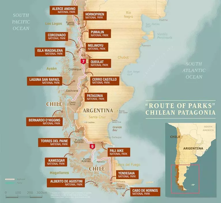
Chile's Route of Parks map - Thompson Conservation.