The Central America Volcanic Arc: Where Ocean Floor Becomes Mountains
The Central America Volcanic Arc (CAVA) represents one of the world's most active and scientifically significant volcanic chains. This geological marvel encompasses more than 70 Holocene volcanoes that have fundamentally shaped the landscape, climate, and human history of Central America.

 https://www.flickr.com/photos/homohominilupus/3168002877")
 https://www.flickr.com/photos/vilseskogen/5533395417")
 https://imaggeo.egu.eu/view/16052/")
 https://www.flickr.com/photos/ableman/2192017406")
 (CC BY-NC-ND 3.0) https://imaggeo.egu.eu/view/2003/")
CAVA: Understanding Central America's Active Volcanic Margin
Stretching over 1,500 kilometers (930 miles) from Guatemala's volcanic highlands to Panama's Cordillera de Talamanca, the Central America Volcanic Arc (CAVA) represents one of the world's most active and scientifically significant volcanic chains. This geological marvel, also known as the Central Volcanic Range, encompasses more than 70 Holocene volcanoes that have fundamentally shaped the landscape, climate, and human history of Central America. The arc's formation results from one of Earth's most powerful geological processes—the relentless subduction of oceanic crust that transforms seafloor sediments into towering volcanic peaks.
Tectonic Foundation and Formation Processes
Subduction Zone Dynamics
The Central America Volcanic Arc owes its existence to the active subduction zone along the Middle America Trench, where the Cocos Plate continuously descends beneath the Caribbean Plate. This oceanic plate, moving eastward at approximately 22 millimeters (0.86 inches) per year, carries millions of years of accumulated marine sediments and basaltic oceanic crust into Earth's interior.
As the Cocos Plate subducts, it encounters increasing temperatures and pressures that trigger complex geochemical processes. Water-rich sediments and altered oceanic crust begin to dehydrate at depths of 100-150 kilometers (62-93 miles), releasing volatile compounds that lower the melting temperature of the overlying mantle wedge. This process generates the magmas that ultimately feed the volcanic arc's numerous eruptions.
Arc-Continent Collision
The Central America Volcanic Arc represents a continental volcanic arc, where subduction-generated magmas intrude and erupt through continental crust rather than forming oceanic island chains. This continental foundation has a significant influence on the composition and explosive character of regional volcanism, as magmas interact with pre-existing crustal rocks during their ascent.
The collision between the volcanic arc and the South American continent, which occurred approximately 3-5 million years ago, fundamentally altered regional geology and initiated the formation of the Central American land bridge. This geological event, known as the Great American Biotic Interchange, allowed terrestrial species to migrate between North and South America for the first time in over 100 million years.
Geological Segmentation
The volcanic arc exhibits distinct geological segments that reflect variations in subduction parameters, crustal structure, and magma composition. The Guatemalan segment, characterized by high-silica magmas and explosive volcanism, contrasts markedly with the Costa Rican segment, where more mafic compositions and effusive eruptions predominate.
These segmentation patterns result from differences in the age and structure of the subducting Cocos Plate, variations in convergence rates and angles, and the influence of hotspot volcanism, particularly the Galápagos hotspot, which affects Costa Rican volcanism through the subduction of the Cocos Ridge.
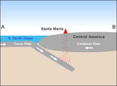
A simplified plate tectonics cross-section illustrates how the Santa Maria Volcano is situated above a subduction zone where the Cocos and Caribbean plates converge.
Volcanic Diversity and Distribution
Stratovolcanoes: The Arc's Giants
The Central America Volcanic Arc's most prominent features are its massive stratovolcanoes, which are composite cones formed through alternating episodes of explosive eruptions and lava flow emplacement. These towering edifices, including Guatemala's Volcán Tajumulco at 4,220 meters (13,845 feet) and Costa Rica's Irazú at 3,432 meters (11,260 feet), represent thousands of years of accumulated volcanic activity.
Stratovolcanoes throughout the arc exhibit characteristic steep profiles, typically ranging from 30 to 35 degrees, maintained by the alternation of strong lava flows and loose pyroclastic deposits. Many feature summit crater complexes, parasitic cones on their flanks, and extensive debris avalanche deposits resulting from periodic collapses of the edifice.
Monogenetic Volcanic Fields
Beyond the major stratovolcanoes, the arc hosts extensive monogenetic volcanic fields comprising hundreds of cinder cones, maars, and small lava domes. These features typically result from single eruptive episodes and provide insight into the deeper magmatic processes that feed the volcanic system.
In El Salvador, the Ilopango volcanic complex demonstrates the range of volcanic phenomena within these fields, from explosive crater formation to dome-building eruptions. Similarly, Nicaragua's Masaya caldera complex showcases the diversity of volcanic processes operating within relatively small geographic areas.
Caldera Systems
Large caldera systems are among the arc's most powerful volcanic features, formed by catastrophic eruptions that empty substantial magma chambers. Guatemala's Los Chocoyos eruption, approximately 84,000 years ago, created the Atitlán caldera and ejected an estimated 300 cubic kilometers (72 cubic miles) of volcanic material across Central America.
Costa Rica's Guayabo caldera, formed roughly 300,000 years ago, and Nicaragua's Apoyo caldera demonstrate the regional significance of large-magnitude eruptions in shaping both landscapes and climates over geological timescales.
Historical and Contemporary Volcanic Activity
Eruptive Patterns and Frequency
Over the past 500 years, the Central America Volcanic Arc has experienced more than 400 documented eruptions, making it one of the world's most volcanically active regions. This activity exhibits significant spatial and temporal variations, with some volcanoes maintaining nearly constant low-level activity while others remain dormant for decades or centuries before producing catastrophic eruptions.
The arc's northern segments, particularly in Guatemala and El Salvador, tend to produce more explosive, silica-rich eruptions, while southern segments in Costa Rica often feature more effusive, basaltic-to-andesitic volcanism. These patterns reflect fundamental differences in magma-generation and crustal-interaction processes along the arc's length.
Major Historical Eruptions
Several eruptions have profoundly impacted regional development and provided crucial scientific insights into arc volcanism. Guatemala's Santa María eruption in 1902 ranks among the largest volcanic events of the 20th century, ejecting approximately 20 cubic kilometers (4.8 cubic miles) of material and creating the ongoing Santiaguito dome complex.
El Salvador's Ilopango eruption, approximately 1,500 years ago, devastated Maya settlements across the region and may have influenced major cultural transitions in Mesoamerican civilizations. More recently, Costa Rica's Arenal volcano provided a natural laboratory for studying sustained strombolian activity from 1968 to 2010.
Current Activity Levels
Contemporary monitoring indicates that approximately 15-20 volcanoes along the arc are active or potentially active. Guatemala's Fuego volcano exemplifies the challenges of living with persistent volcanic activity, producing frequent explosions and pyroclastic flows that threaten nearby communities while providing spectacular displays of geological processes.
Costa Rica's Turrialba and Poás volcanoes have exhibited increased activity in recent years, demonstrating the dynamic nature of arc volcanism and the importance of continuous monitoring for hazard mitigation. Nicaragua's Masaya volcano maintains a persistent lava lake, offering unique opportunities to study ongoing magmatic processes.
Volcanic Hazards and Risk Assessment
Primary Volcanic Hazards
The Central America Volcanic Arc generates multiple categories of volcanic hazards that affect millions of people across the region. Pyroclastic flows represent the most immediate and deadly threat, capable of traveling at speeds exceeding 200 kilometers per hour (124 mph) and reaching temperatures above 800°C (1,472°F).
Volcanic ash poses widespread hazards extending far beyond individual volcanic centers. Major eruptions can distribute ash across entire countries, disrupting aviation, agriculture, water supplies, and human health. The 1963 Irazú eruption in Costa Rica deposited ash on the capital city of San José for over two years, demonstrating the potential for sustained regional impacts.
Lahars, or volcanic debris flows, present ongoing hazards during both eruptive and non-eruptive periods. These concrete-like flows form when volcanic deposits mix with water from rainfall, crater lakes, or the melting of snow and ice, and can travel tens of kilometers from their source volcanoes.
Secondary Hazards and Long-term Impacts
Volcanic activity generates numerous secondary hazards that can persist for years or decades following eruptions. Post-eruptive erosion and sediment transport alter drainage systems, increase flood risks, and affect coastal areas through increased sediment delivery.
Volcanic gases, including sulfur dioxide, carbon dioxide, and hydrogen sulfide, pose health hazards for nearby communities and can contribute to regional air quality problems. Long-term exposure to volcanic ash can lead to respiratory issues, while volcanic gas emissions contribute to the formation of acid rain.
Population Vulnerability
The hazards of the Central America Volcanic Arc are amplified by the region's dense population distribution, with major capitals such as Guatemala City, San Salvador, Managua, and San José located within 50 kilometers (31 miles) of active or potentially active volcanoes. This proximity creates significant challenges for hazard mitigation and emergency preparedness.
Rural communities often face greater vulnerability due to limited resources for volcano monitoring, emergency response capabilities, and evacuation infrastructure. Traditional building materials and construction techniques may be inadequate for protecting against volcanic hazards, particularly ash loading and pyroclastic flow impacts.
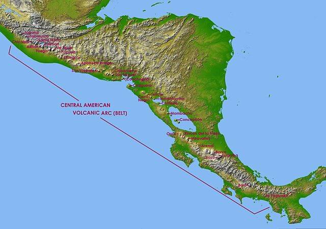
Map depicting the Central America Volcanic Arc.
Regional Climate and Environmental Impacts
Volcanic Influence on Regional Climate
The Central America Volcanic Arc significantly influences regional climate patterns through multiple mechanisms. Large explosive eruptions inject sulfur compounds and ash into the stratosphere, where they can affect regional and global climate for months or years following major events.
The arc's topographic effects create complex precipitation patterns as moisture-laden air masses encounter the volcanic mountain chain. Windward slopes typically receive substantially more precipitation than leeward areas, creating diverse microclimates and ecosystems across relatively short distances.
Volcanic emissions significantly contribute to regional atmospheric chemistry, with persistent gas emissions from active volcanoes affecting local air quality and influencing broader atmospheric processes. These emissions can influence cloud formation, precipitation chemistry, and regional visibility patterns.
Soil Formation and Agricultural Productivity
Volcanic activity has created some of Central America's most fertile agricultural soils through the weathering of volcanic ash and lava deposits. These andisols exhibit exceptional nutrient retention and water-holding capacity, supporting intensive agriculture despite challenging topographic conditions.
The periodic addition of fresh volcanic ash provides natural fertilization for agricultural systems, though the immediate impacts of ash deposition can be devastating to crops and livestock. Long-term agricultural productivity in volcanic regions reflects the balance between periodic destruction and soil enrichment processes.
Coffee cultivation throughout the Central American highlands exemplifies successful adaptation to volcanic environments, with high-elevation volcanic soils producing some of the world's finest arabica varieties. The combination of fertile soils, a favorable climate, and elevation gradients created by volcanic topography provides ideal conditions for the production of specialty crops.
Biodiversity and Ecosystem Development
Elevation-Dependent Ecosystems
The Central America Volcanic Arc's elevational gradients create diverse ecosystem mosaics that support exceptional biodiversity. From tropical lowland forests at volcanic bases to alpine paramo communities near summit areas, elevation changes of over 4,000 meters (13,120 feet) provide habitat for species adapted to dramatically different environmental conditions.
Cloud forests, characteristic of mid-elevation volcanic slopes, support unique assemblages of endemic species adapted to persistent fog and high humidity conditions. These ecosystems serve crucial functions in watershed protection while harboring exceptional biological diversity.
High-elevation volcanic environments support specialized plant communities that are adapted to extreme temperature variations, intense ultraviolet radiation, and frequent volcanic disturbances. Many species exhibit adaptations such as rosette growth forms, waxy leaf surfaces, and extensive root systems that enable survival in harsh volcanic conditions.
Ecological Succession and Disturbance
Volcanic eruptions create natural experiments in ecological succession, providing opportunities to study how biological communities develop on newly created substrates. Primary succession on lava flows and pyroclastic deposits demonstrates the resilience of tropical ecosystems and the processes by which biological diversity develops over time.
Different volcanic substrates support distinct successional pathways, with porous volcanic materials typically supporting more rapid plant colonization than dense lava flows. Pioneer species adapted to volcanic environments often exhibit specialized traits for survival on nutrient-poor, unstable substrates.
Endemic species throughout the arc often exhibit adaptations to periodic volcanic disturbances, including rapid reproduction, efficient dispersal, and tolerance of environmental stress. These adaptations reflect millions of years of evolution in volcanically active landscapes.
Scientific Research and Monitoring
Volcano Observatory Networks
The Central America Volcanic Arc hosts several sophisticated volcano monitoring networks operated by national geological surveys and international research institutions. These facilities utilize seismic monitoring, gas emission measurements, thermal imaging, and satellite remote sensing to track volcanic activity and assess hazard levels.
Costa Rica's Observatorio Vulcanológico y Sismológico de Costa Rica (OVSICORI) exemplifies modern volcano monitoring, maintaining real-time surveillance of the country's active volcanic systems. Similar facilities in Guatemala (INSIVUMEH), El Salvador (SNET), and Nicaragua (INETER) provide regional monitoring capabilities and coordinate international research efforts.
Advances in monitoring technology, including thermal cameras, gas sensors, and satellite imagery, enable increasingly sophisticated tracking of volcanic processes and improved eruption forecasting capabilities. These technological developments are crucial for protecting vulnerable populations and supporting scientific research.
International Research Collaboration
The Central America Volcanic Arc serves as a natural laboratory for international volcanic research, with scientists from universities and research institutions worldwide studying various aspects of arc volcanism. Research topics range from fundamental magma-generation processes to applied hazard assessment and risk-mitigation strategies.
Long-term research programs have documented the evolution of individual volcanic systems, the controls on eruption magnitude and frequency, and the relationships between volcanic activity and regional tectonic processes. These studies contribute to a broader understanding of subduction zone volcanism worldwide.
Interdisciplinary research incorporating geology, geophysics, geochemistry, ecology, and anthropology provides comprehensive insights into the complex relationships between volcanic processes and human societies. These integrated approaches are crucial for developing effective strategies for managing volcanic hazards.
Economic and Social Impacts
Economic Benefits of Volcanism
Despite their hazards, volcanoes throughout the Central America Volcanic Arc provide significant economic benefits to regional communities. Fertile volcanic soils support intensive agriculture, particularly coffee production, which represents a major export industry for most Central American countries.
Geothermal energy development utilizes volcanic heat sources to generate electricity and provide direct heating applications. Countries such as Costa Rica and El Salvador derive substantial portions of their electrical energy from geothermal resources associated with volcanic activity.
Tourism related to volcanic landscapes generates significant economic activity throughout the region. National parks protecting volcanic areas attract millions of visitors annually, supporting local communities through employment in hospitality, guiding, transportation, and related services.
Cultural and Historical Significance
Volcanic landscapes have profoundly influenced Central American cultures throughout human history. Pre-Columbian civilizations developed a sophisticated understanding of volcanic processes and incorporated volcanic materials into architecture, tools, and ceremonial objects.
Contemporary Indigenous communities maintain traditional ecological knowledge of volcanic environments, including an understanding of eruption precursors, seasonal patterns of volcanic activity, and sustainable resource-use practices adapted to volcanic landscapes.
Colonial and modern settlements reflect ongoing adaptation to volcanic hazards through architectural styles, urban planning strategies, and social institutions designed to mitigate the impact of periodic volcanic disruptions. These cultural adaptations represent thousands of years of accumulated experience living with active volcanism.
Future Challenges and Research Directions
Climate Change Interactions
Climate change may significantly impact volcanic hazards and their effects throughout the Central America Volcanic Arc. Changing precipitation patterns could alter the frequency and magnitude of volcanic debris flows, while temperature increases might affect high-elevation volcanic ecosystems and permanent ice cover on the highest peaks.
Sea-level rise and changing storm patterns could impact volcanic hazards in coastal areas, particularly through interactions between volcanic debris flows and coastal flooding. These complex interactions require interdisciplinary research approaches and adaptive management strategies.
Population Growth and Urbanization
Continued population growth and urbanization throughout Central America will increase exposure to volcanic hazards, particularly in areas surrounding major volcanic centers. Developing effective hazard mitigation strategies requires integrating volcano monitoring, land-use planning, and emergency preparedness systems to enhance overall resilience.
Building resilient communities in volcanic regions requires striking a balance between economic development opportunities and hazard reduction objectives. This challenge is particularly acute in areas where volcanic landscapes provide both resources and risks for human settlements.
Technological Advances
Emerging technologies offer new possibilities for volcano monitoring and hazard mitigation. Advanced satellite systems, autonomous monitoring platforms, and artificial intelligence applications may enable more sophisticated eruption forecasting and risk assessment capabilities.
The integration of monitoring data with numerical models of volcanic processes offers opportunities for enhanced understanding of magma chamber dynamics, eruption triggering mechanisms, and hazard propagation patterns. These advances are essential for protecting increasingly vulnerable populations.
Conclusion
The Central America Volcanic Arc is one of Earth's most dynamic and scientifically significant geological features, representing the ongoing transformation of oceanic crust into continental mountain ranges through subduction-zone processes. Over 1,500 kilometers (930 miles) of volcanic landscape document millions of years of tectonic evolution while continuing to shape regional geography, climate, and human societies.
The arc's more than 70 Holocene volcanoes encompass an extraordinary diversity of volcanic processes, ranging from the explosive andesitic eruptions characteristic of Guatemala and El Salvador to the more effusive basaltic volcanism of Costa Rica. This diversity reflects complex interactions between subduction parameters, crustal structure, and mantle dynamics that continue to drive volcanic activity throughout the region.
Understanding the Central America Volcanic Arc requires recognizing the fundamental connections among geological processes, ecological systems, and human societies that have developed over millennia. The arc's volcanic hazards pose ongoing challenges for millions of people, while its fertile soils, geothermal resources, and spectacular landscapes provide essential foundations for regional economies and cultures.
Future research and monitoring efforts must address the complex challenges of protecting vulnerable populations while supporting sustainable development in volcanic regions. Success in these endeavors requires continued scientific investigation, technological innovation, and international cooperation to develop a comprehensive understanding of arc volcanism and its implications for human societies and natural ecosystems.
The Central America Volcanic Arc will continue to serve as a natural laboratory for understanding subduction zone processes, volcanic hazards, and the complex relationships between geological forces and life on Earth. Its ongoing evolution provides opportunities to advance scientific knowledge while demonstrating the remarkable adaptability of both natural systems and human societies to one of our planet's most powerful geological phenomena.