
Brasília: A Modernist Utopia in the Heart of Brazil
Founded in 1960 on the Cerrado plateau of central Brazil, Brasília is a planned capital designed by Lúcio Costa and Oscar Niemeyer and has been a UNESCO World Heritage Site since 1987. About 2.8 million people live in the Federal District, which makes it Brazil's third-largest city, and its monumental axes, artificial lake, and modernist landmarks are among the most studied examples of 20th-century urban planning.
Brasília: Brazil's Planned Capital Between Cerrado and Sky
Brasília is the federal capital of Brazil and the seat of its three branches of government. Founded on April 21, 1960, on a high plateau in the Brazilian Highlands, it was built from scratch in just 41 months to move the country's center of power inland from the coast. Designed by the urban planner Lúcio Costa and the architect Oscar Niemeyer, it is one of the most ambitious planned cities of the twentieth century and has been a UNESCO World Heritage Site since 1987. The capital forms the center of the Federal District, which has about 2.8 million people and is the third-largest city in Brazil.
Why Brazil Built a New Capital
Brazilians had talked about moving the capital inland since the nineteenth century, and the 1891 constitution even reserved land for it. The idea took off under President Juscelino Kubitschek, who took office in 1956 with the slogan "fifty years of progress in five" and made the new capital the centerpiece of his program. Moving the government away from Rio de Janeiro was meant to open up the vast, thinly populated interior and to symbolize a modern, forward-looking nation. Lúcio Costa's design won a national competition in 1957; Oscar Niemeyer was chief architect of the public buildings, engineer Joaquim Cardozo handled their structures, and Roberto Burle Marx designed the landscapes. The capital was inaugurated on April 21, 1960, and the government gradually moved from Rio over the following years.
The Pilot Plan
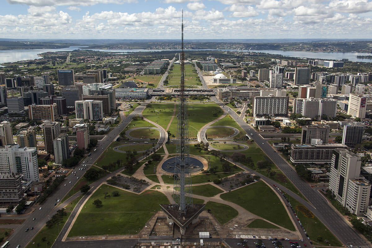
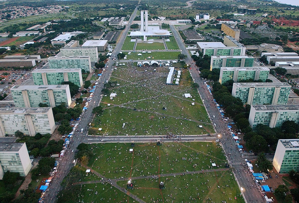
Costa's Plano Piloto, or Pilot Plan, centers on two crossing axes. The Monumental Axis runs east to west along the Esplanade of the Ministries, lined with the federal government buildings, and the Residential Axis curves north to south through the housing districts. Seen from above, the layout resembles an airplane or a bird in flight. The city is organized into functional sectors for hotels, banking, embassies, culture, and other uses, and housing is arranged in superblocks (superquadras), groups of apartment buildings up to six floors high, raised on pylons so open green space flows beneath them. The design reflects the influence of the Swiss-French architect Le Corbusier and his ideas of separating pedestrians from traffic and zoning the city by function.
Architecture and Landmarks
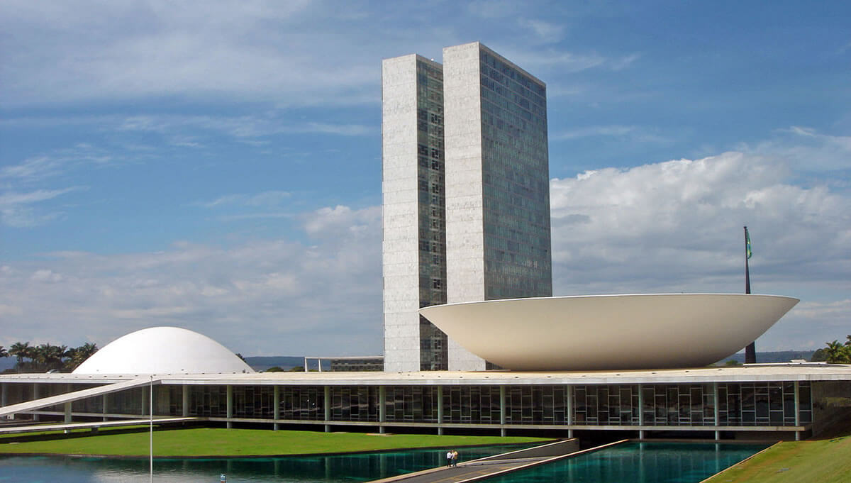
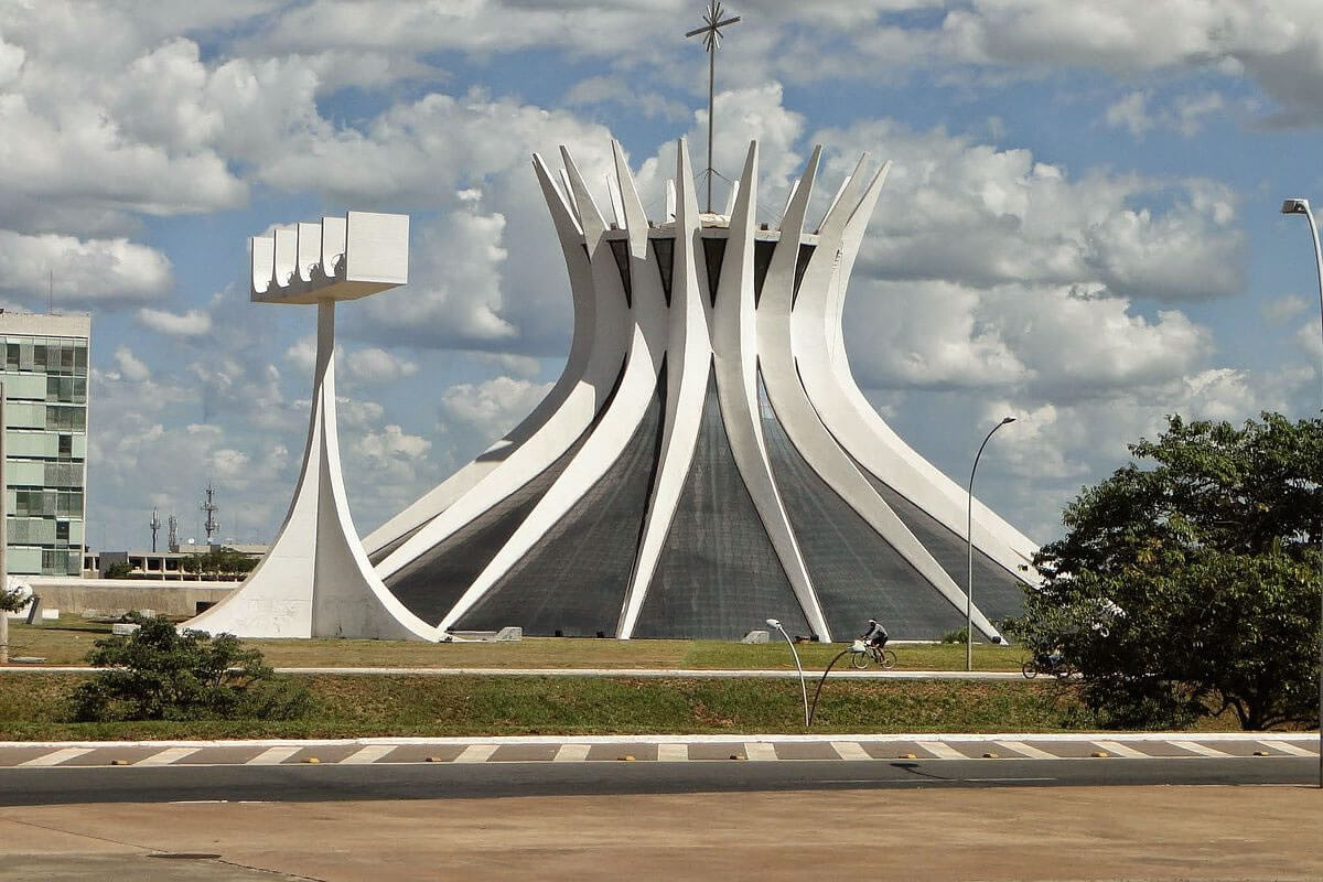
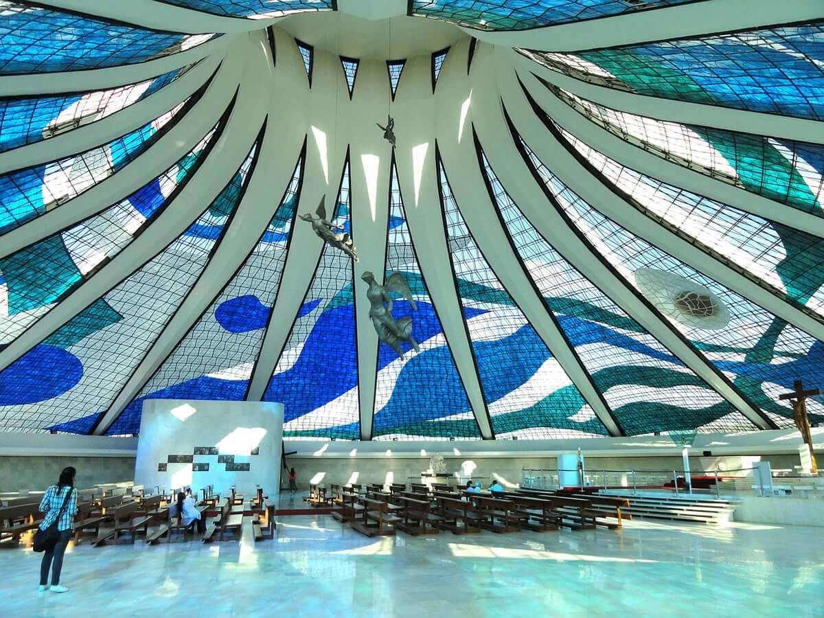
At the eastern end of the Monumental Axis, the Praça dos Três Poderes (Three Powers Square) brings together the Planalto Palace, the president's official workplace; the National Congress; and the Supreme Federal Court. The Congress is recognizable by its twin office towers flanked by two domes, one convex for the Senate and one concave for the Chamber of Deputies. Nearby, the Palácio da Alvorada, the president's official residence, stands on a peninsula of Lake Paranoá. The Cathedral of Brasília, completed in 1970 and designed by Niemeyer with Cardozo, rises from 16 curved concrete columns that form a hyperboloid crown about 40 m (130 ft) high, with stained glass between the columns. Other landmarks include the television tower on the Monumental Axis, the National Theater, and the Juscelino Kubitschek Bridge across the lake, a 1,200 m (3,900 ft) crossing completed in 2002 with three 60 m (197 ft) steel arches.
UNESCO World Heritage and Creative City
UNESCO inscribed Brasília on the World Heritage List in 1987 under criteria (i) and (iv), calling it a definitive example of twentieth-century modernist urbanism. The protected area covers 11,268.92 ha (113 km², or 43.5 sq mi) and includes the intersecting axes, sectors, open and green spaces, the Esplanade, and Niemeyer's key buildings. UNESCO also lists pressures on the property, among them real-estate development, illegal occupation of public and green areas, encroachment on the lakefront, and increasing traffic. In 2017, the city also joined UNESCO's Creative Cities Network as a City of Design.
Lake Paranoá
Lake Paranoá is an artificial lake formed by damming the Paranoá River during the city's construction. It covers about 48 km² (19 sq mi), averages 12 m (39 ft) deep, reaches 38 m (125 ft), and has a shoreline of about 80 km (50 mi). It softens the dry climate, provides water and recreation, and wraps around the city's northern and southern edges, where the Lago Sul and Lago Norte districts, embassies, clubs and the University of Brasília line its shores. Three islands in the lake are ecological reserves. Four streams, the Torto, Gama, Riacho Fundo and Bananal, feed it.
Climate and the Cerrado
Brasília lies in the Cerrado, Brazil's tropical savanna, at roughly 1,000 to 1,170 m (3,300 to 3,850 ft) above sea level, with a tropical wet-and-dry climate. The mean temperature is about 21.4 °C (70.5 °F), with a record high of 36.4 °C (97.5 °F) and a record low of 1.6 °C (34.9 °F). Rainfall averages about 1,480 mm (58 in) a year. Rain falls almost entirely from October to April, while July is nearly rainless (about 1.5 mm, or 0.06 in), and humidity often drops below 30 percent in the dry season.
Brasília National Park, established in 1961, protects about 420 km² (162 sq mi) of Cerrado just north of the Pilot Plan, including dry forest, grassland, and gallery forest along streams, and it was created to protect the springs that supply the capital's water. Wildlife includes the maned wolf (Chrysocyon brachyurus), giant anteater (Myrmecophaga tridactyla), pampas deer (Ozotoceros bezoarticus), South American tapir (Tapirus terrestris), blue-and-yellow macaw (Ara ararauna), toco toucan (Ramphastos toco), and red-legged seriema (Cariama cristata). Its spring-fed Água Mineral pool is a popular swimming spot. The wider region and its protected areas are described in Cerrado Protected Areas and Chapada dos Veadeiros.
People and Administrative Regions
The 2022 census counted about 2.82 million people in the Federal District, a 9.6 percent rise since 2010, making it the second-largest absolute gain in Brazil after Manaus. Including surrounding municipalities, the urban concentration had 3.82 million people, and the 2025 estimate for the metropolitan area is about 3.5 million. The Federal Capital covers 5,802 km² (2,240 sq mi), and most residents live outside the Pilot Plan, in the 35 administrative regions often called satellite cities. Ceilândia is the most populous, followed by Samambaia and the Plano Piloto, and Águas Claras is the most densely populated. In the 2022 census, 48.7 percent of residents identified as pardo (mixed-race), 40 percent as white, and 10.7 percent as Black.
Economy and Transport
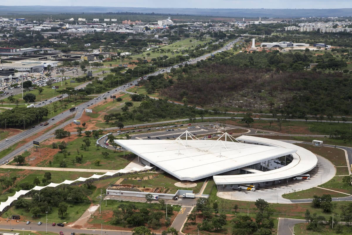
Government is the capital's economic base: public administration accounts for more than half of the Federal District's economy, and services make up most of the rest, with little industry or agriculture. Per capita income is the highest in Brazil, although the gap between the Pilot Plan and the outlying regions is wide. Brasília–Presidente Juscelino Kubitschek International Airport, about 11 km (7 mi) from the center, is one of the country's busiest airports, and the Federal District Metro has 24 stations on two lines over about 43 km (27 mi). The city's car-oriented design, with wide avenues and long distances between sectors, makes public transport a continuing challenge.
January 8, 2023
On January 8, 2023, a week after President Luiz Inácio Lula da Silva took office, thousands of supporters of former President Jair Bolsonaro stormed the National Congress, the Planalto Palace, and the Supreme Federal Court in Praça dos Três Poderes. The rioters destroyed furniture and damaged artworks, including paintings and sculptures by leading Brazilian artists, and repair and security costs were estimated at least at R$ 16 million. Authorities detained more than 2,000 people, and by November 2024 the Supreme Court had convicted 265 of them. The attack served as a reminder for everyone that the buildings of the Praça, designed as symbols of the republic, are also the stage for its political conflicts.
Criticism and Challenges
Brasília has long been admired and criticized in equal measure. Its monumental scale, wide avenues, and separation of functions give the Pilot Plan a unique clarity. Still, critics argue the city was designed for cars rather than pedestrians and that the planned core displaced workers who built it, pushing them to satellite settlements far from jobs. The Federal District has grown far beyond the original plan, and pressure on the heritage zone is real and ongoing.
Conclusion
Brasília remains one of the boldest experiments in urban planning. As the home of the Brazilian state, a World Heritage Site and a living city of nearly three million people, it shows both the power and the limits of designing a capital from a blank sheet of paper.