The Geography of French Guiana: Europe's Amazonian Territory at the Crossroads of Space and Conservation
French Guiana, situated on the northeastern coast of South America, serves as a gateway to the Amazon Basin. This strategic position has influenced both its political importance and its impressive geographic diversity, which ranges from coastal mangroves to the untouched Amazonian rainforests.


 https://www.researchgate.net/figure/Aerial-view-of-French-Guiana-rainforest-in-the-region-of-the-Mitaraka-Massif-Photo-ss_fig9_301937578")
Between the Amazon and Atlantic: Understanding French Guiana's Geographic Landscape
French Guiana, officially an overseas collectivity of France, occupies a unique position in the geographic tapestry of South America. Located on the northeastern coast of the continent at approximately 4°N and 53°W, this territory serves as Europe's gateway to the Amazon Basin while maintaining its distinct French identity. Covering an area of roughly 83,534 square kilometers (32,253 square miles), French Guiana is bordered by Brazil to the south and east, Suriname to the west, and the Atlantic Ocean to the northeast. This strategic location has not only shaped its political significance but also its remarkable geographic diversity, ranging from coastal mangroves to pristine Amazonian rainforests.
Physical Geography and Topography
Geological Structure and Relief
French Guiana's landscape can be divided into three distinct topographical regions, each representing different geological formations and elevations. The northern coastal region consists of extensive low-lying plains that rarely exceed 30 meters (98 feet) above sea level. These plains, formed by sedimentary deposits from rivers and marine processes, create a flat, marshy landscape behind a belt of mangrove forests along the Atlantic coastline.
Moving inland, the terrain transitions into a central hilly plateau region characterized by undulating hills and scattered plains. This intermediate zone serves as a buffer between the coastal lowlands and the more mountainous interior. The landscape here is marked by ancient weathered rocks of the Guiana Shield, one of the World's oldest geological formations, dating back over 2 billion years.
The southern region is dominated by the Tumuc-Humac Mountains, which form an eastern extension of the Acarai Mountains and are part of the broader Guiana Highlands system. These ancient mountains, while modest in height, represent some of the oldest exposed rock formations on Earth. The highest point in French Guiana is Bellevue de l'Inini, reaching 851 meters (2,792 feet) above sea level. Despite their relatively low elevation, these mountains create significant geographic barriers and contribute to the territory's impressive biodiversity by providing diverse ecological niches.
Hydrographic Network
French Guiana's river system is both extensive and vital to the territory's geography and ecology. More than twenty rivers traverse the landscape, with two primary waterways serving as crucial geographic boundaries. The Oyapock River forms the eastern border with Brazil, flowing northward from the Tumuc-Humac Mountains to the Atlantic Ocean. This river system drains a significant portion of the southeastern territory and serves as a vital transportation corridor.
The Maroni River system, including the Maroni and Itani rivers, defines the western boundary with Suriname. These rivers are particularly significant as they flow through some of the most pristine rainforest areas in South America, supporting incredible biodiversity and serving traditional communities that depend on them for transportation and sustenance.
Other notable rivers include the Sinnamary, Approuague, and Mana rivers, each contributing to the complex network of waterways that drain French Guiana's interior toward the Atlantic. These rivers have carved deep valleys through the ancient rocks of the Guiana Shield, creating a dendritic drainage pattern that facilitates the flow of nutrients from the interior forests to the coastal plains.
Coastal Features
French Guiana's Atlantic coastline stretches for approximately 320 kilometers (199 miles) and is characterized by a complex interplay of marine and terrestrial processes. The coast is predominantly flat and marshy, protected by extensive mangrove forests that serve as crucial buffers against storms and coastal erosion. These mangrove ecosystems are among the most productive in the World, supporting a diverse array of species and filtering sediments carried by rivers.
Off the coast lie several significant islands, most notably the Îles du Salut (Islands of Salvation), which include Devil's Island (Île du Diable). These rocky islands, located approximately 15 kilometers (9 miles) from the mainland, were historically used as penal colonies and remain important both historically and ecologically. The surrounding waters are influenced by the powerful Guiana Current, which affects local marine ecosystems and coastal processes.
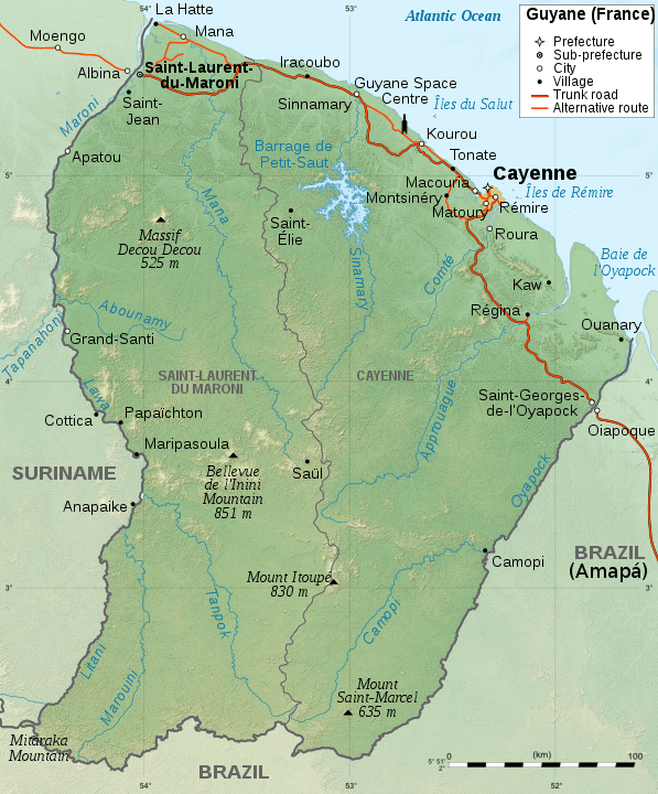
Geographic map of French Guiana.
Climate and Weather Patterns
Tropical Climate Classification
French Guiana's climate is tropical and hot with a Köppen climate classification of tropical rainforest (Af) throughout most of the country. The average temperature is approximately 27°C (81°F), and the humidity typically ranges from 85%. This consistently warm and humid climate, characteristic of equatorial regions, creates ideal conditions for the lush rainforest ecosystems that dominate the territory.
Temperature variations throughout the year are minimal, with the thermometer rarely falling below 22°C (72°F) or rising above 32°C (90°F). The high humidity levels, often exceeding 80%, contribute to the perception of intense heat and create the perfect conditions for the rapid growth of vegetation and the cycling of nutrients through forest ecosystems.
Seasonal Patterns
The region's climate is characterized by two main seasons: a wet season and a dry season, although the distinction is more pronounced in terms of rainfall intensity than temperature variation. Most precipitation falls from January to June, during the wet season when the Intertropical Convergence Zone (ITCZ) is positioned over the region. During this period, heavy showers, severe thunderstorms, and floods are frequent.
The best time for traveling is from August to November, which corresponds to the dry season when rainfall is reduced but not eliminated. Even during the dry season, French Guiana receives significant precipitation, thanks to the territory's location, which ensures year-round moisture from the Atlantic Ocean and the vast Amazon Basin.
Annual precipitation varies across the territory, generally ranging from 2,000 to 4,000 millimeters (79 to 157 inches), with higher amounts recorded in the interior mountains where orographic effects enhance rainfall. This abundant precipitation supports the luxuriant rainforest vegetation and maintains the complex hydrological cycles that characterize Amazonian ecosystems.
Biogeography and Ecosystems
Amazonian Rainforest Dominance
The tropical forests of French Guiana cover approximately 8 million hectares and represent some of the most pristine Amazonian ecosystems remaining on the Planet. They are ecologically Amazonian, historically French, and politically European, and constitute a tropical rainforest, characterized by considerable biodiversity and relatively uninterrupted forest cover.
These forests exhibit the classic characteristics of Amazonian rainforests: multiple canopy layers, extraordinary species diversity, and complex ecological relationships. The canopy typically reaches heights of 30-40 meters (98-131 feet), with emergent trees occasionally reaching 50 meters (164 feet) or more. The forest structure creates numerous microhabitats, from the dark forest floor to the sun-drenched emergent layer, each supporting specialized plant and animal communities.
Biodiversity Richness
Five thousand five hundred plant species have been recorded, including more than a thousand trees, along with 700 species of birds, 177 species of mammals, over 500 species of fish, including 45% of which are endemic, and 109 species of amphibians—this remarkable diversity places French Guiana among the most biodiverse regions on Earth, considering its size.
The flora includes numerous endemic species adapted to specific ecological niches within the forest ecosystem. Among the most notable plant families are the Leguminosae, with species such as those in the Swartzia and Inga genera being particularly common. The forests also support valuable timber species, including various members of the Lecythidaceae family, such as Couratari species, and numerous palm species, including Euterpe oleracea (açaí palm) and Mauritia flexuosa (moriche palm).
The fauna represents a cross-section of Neotropical biodiversity. Large mammals include the jaguar (Panthera onca), the largest predator in the Americas, and the giant otter (Pteronura brasiliensis), an endangered aquatic mammal found in the rivers of the territory. The primate community is particularly rich, with species such as the red howler monkey (Alouatta macconnelli), various capuchin species (Cebus spp.), and several species of night monkeys (Aotus spp.).
Bird diversity is exceptional, with species ranging from large raptors, such as the harpy eagle (Harpia harpyja), to tiny hummingbirds, like the white-necked jacobin (Florisuga mellivora). The territory serves as an important corridor for migratory species, supporting numerous endemic subspecies that are adapted to specific forest habitats.
Specialized Ecosystems
Beyond the dominant rainforest, French Guiana contains several specialized ecosystems that contribute to its overall biodiversity. Coastal mangrove forests, dominated by species such as Rhizophora mangle (red mangrove) and Avicennia germinans (black mangrove), provide crucial nursery habitats for marine species and protection against coastal erosion.
The Amazonian savannas of French Guiana are rare and of high ecological and cultural value, but are also highly threatened. These grassland ecosystems, scattered throughout the forest matrix, support unique plant and animal communities adapted to periodic flooding and fire. They represent relic ecosystems that may have been more extensive during drier climatic periods in the past.
Freshwater ecosystems, including rivers, streams, and temporary pools, support remarkable aquatic biodiversity. The high level of endemism in fish species reflects the long evolutionary history of these isolated watersheds and the complex geography of the Guiana Shield.
Human Geography and Environmental Challenges
Settlement Patterns and Land Use
The distribution of the human population in French Guiana closely reflects the territory's geographic constraints and opportunities. Approximately 90% of the population lives within the coastal plain region, concentrated in and around the capital city of Cayenne and the space center at Kourou. This coastal concentration reflects both the challenging nature of the interior forests and the economic opportunities provided by the territory's connection to global markets through Atlantic ports.
The interior regions remain sparsely populated, with small Indigenous communities and Maroon populations living along major rivers. These communities have developed sophisticated knowledge systems for navigating and utilizing the forest environment, representing important cultural adaptations to the geographic challenges of the Amazonian environment.
Conservation and Environmental Pressure
French Guiana faces significant environmental challenges despite its relatively pristine condition. Illegal gold mining poses one of the most important threats to the territory's ecosystems, with operations frequently located in remote, interior regions that are challenging to monitor and control. President Macron visited the area in 2024 to commemorate French special forces major Arnaud Blanc, who died during an operation against illegal gold mining in Maripasoula, highlighting the ongoing struggle to protect the territory's natural resources.
The territory's forests serve as important carbon sinks and repositories of global biodiversity, making their conservation crucial not only for local ecosystems but for global environmental stability. Climate change poses additional challenges, with potential shifts in precipitation patterns and increased frequency of extreme weather events threatening both human communities and natural ecosystems.
Economic Geography
Natural Resource Endowment
French Guiana's geography has endowed it with significant natural resources, though their exploitation often conflicts with conservation goals. The territory contains substantial gold deposits, concentrated primarily in the interior regions along ancient geological formations. While gold mining provides economic opportunities, it also represents the greatest environmental threat to the territory's pristine ecosystems.
Forest resources, including valuable timber species, represent another significant natural endowment. However, sustainable forest management practices are essential for preserving the ecological integrity of these ecosystems while generating economic benefits for local communities.
Strategic Economic Assets
The Guiana Space Centre at Kourou represents one of the most significant economic assets in French Guiana, capitalizing on the territory's advantageous geographic location near the equator. This positioning provides substantial advantages for satellite launches, as the Earth's rotational velocity is greatest at the equator, reducing the energy required to achieve orbital velocities.
The space center has transformed the local economy and established French Guiana as a crucial component of European space operations. A new European Ariane 6 launch system continues to utilize this geographic advantage, ensuring the territory's continued importance in global space activities.
Conclusion
French Guiana's geography represents a unique confluence of Amazonian wilderness, European governance, and global significance. Its position at the northeastern edge of South America has created a territory of exceptional biodiversity, ancient geological formations, and strategic importance. The three-tiered topographical structure, ranging from coastal plains to central plateaus and interior mountains, provides the foundation for diverse ecosystems that harbor some of the Planet's most pristine tropical forests.
The territory's hydrographic network, dominated by major rivers that serve as international boundaries, connects the ancient highlands to the Atlantic Ocean, creating corridors for both biological diversity and human settlement. The tropical climate, characterized by high temperatures, humidity, and abundant rainfall, sustains the lush rainforest ecosystems that define the territory's ecological character.
As French Guiana continues to balance conservation priorities with economic development, its geographic advantages will remain crucial to its future. The territory's role as a repository of Amazonian biodiversity, its strategic location for space operations, and its position as Europe's South American territory ensure that understanding its geography remains essential for appreciating both its current significance and future potential. The ongoing challenges of environmental protection, sustainable development, and climate change adaptation will continue to be shaped by the fundamental geographic characteristics that make French Guiana one of the most unique territories in the World.