Nicoya: A Blend of Biodiversity and Heritage in Costa Rica
The Nicoya Peninsula and the Gulf of Nicoya in Costa Rica are known for their stunning landscapes, rich biodiversity, and cultural heritage. They offer a unique blend of natural beauty and historical significance, making them essential destinations for understanding Costa Rica's diversity.
 https://www.flickr.com/photos/mstrniste/6738829901")
 https://www.flickr.com/photos/mstrniste/6738841581/in/album-72157627333652107/")
 https://www.flickr.com/photos/milestuttle/5307811318")
 and Bejuco (right), Nicoya Peninsula, Costa Rica - via Wikimedia Commons Rodtico21 [CC BY-SA (https://creativecommons.org/licenses/by-sa/3.0)]")
]")

The Nicoya Peninsula and Gulf of Nicoya: A Natural and Cultural Haven in Costa Rica
The Nicoya Peninsula and the Gulf of Nicoya are two of Costa Rica's most captivating regions, known for their stunning landscapes, rich biodiversity, and vibrant cultural heritage. Situated along the northern section of the Pacific coast, the Nicoya Peninsula stretches across two provinces—Guanacaste in the north and Puntarenas in the south—while the Gulf of Nicoya indents the west-central part of the coastline. These areas offer a unique blend of natural beauty and historical significance, making them essential destinations for understanding Costa Rica's ecological and cultural diversity.
Geographic and Physical Features
Nicoya Peninsula
The Nicoya Peninsula, the largest in Costa Rica, measures approximately 140 km (85 miles) in length and varies in width from 65 to 96 km (40 to 60 miles). Bordered by the Pacific Ocean on the west and south, the peninsula is flanked by the Cordillera de Guanacaste to the northeast and the Gulf of Nicoya to the southeast. The region's topography is diverse, beginning with the arid lowlands of Guanacaste at its base and rising abruptly to over 900 meters (3,000 feet) in the central and southern mountain ranges. This varied landscape supports a range of ecosystems, from dry forests to lush, mountainous terrains.
The principal town of Nicoya, along with other significant villages, is well-connected by highways to Liberia, the capital of Guanacaste province. Additionally, ferry services link the peninsula to the mainland port of Puntarenas, facilitating transportation and commerce.
Gulf of Nicoya
The Gulf of Nicoya is a prominent inlet extending about 80 km (50 miles) northward and northwestward from Cape Blanco (Cabo Blanco). This gulf separates the Nicoya Peninsula from mainland Costa Rica, featuring a diverse marine and coastal landscape with wetlands, rocky islands, and cliffs. The Tempisque, Abangares, and Tárcoles rivers empty into the gulf, contributing to its ecological richness.
A historical geological fault caused the land to submerge, leaving the tops of former low hills exposed as islands, the most notable of which are Chira and San Lucas. The upper end of the gulf is characterized by shallow, muddy waters, with the Tempisque River, depositing significant amounts of soil and organic material, fostering extensive mangrove swamps.
Ecological Significance
Biodiversity and Habitats
The Nicoya Peninsula and the Gulf of Nicoya are ecological treasures, home to a wide array of flora and fauna. The peninsula's varying altitudes and climates support diverse habitats, including tropical dry forests, cloud forests, and coastal ecosystems. These environments are rich in wildlife, offering refuge to numerous species of birds, mammals, and reptiles.
The Gulf of Nicoya's mangroves are particularly vital for maintaining ecological balance. These mangroves provide crucial habitats for aquatic life, including mussels, crabs, and shrimps. Birds nest in the dense foliage, while the muddy roots serve as nurseries for many marine species. The Palo Verde National Park, located along the Tempisque River, is one of Central America's most densely populated areas for migratory birds, making it a key site for birdwatching and conservation efforts.
Cultural Heritage
Pre-Columbian Influence
The Nicoya Peninsula is steeped in cultural history and significantly influenced by the pre-Columbian Chorotega-Mangues Indians. Descendants of these indigenous peoples still inhabit villages on the peninsula, preserving traditions and cultural practices that date back centuries. This enduring cultural presence often distinguishes Nicoya from other parts of Costa Rica, highlighting its unique historical and anthropological significance.
Connectivity and Accessibility
The Nicoya Peninsula's infrastructure ensures that it remains accessible while preserving its natural and cultural heritage. Highways connecting major towns and villages facilitate easy travel across the region. The ferry service to Puntarenas on the mainland enhances connectivity, supporting both local communities and tourism.
Conclusion
The Nicoya Peninsula and the Gulf of Nicoya embody Costa Rica's rich natural and cultural tapestry. From the arid lowlands and mountainous terrains of the peninsula to the gulf's biologically rich waters and islands of the gulf, these regions offer an unparalleled glimpse into the country's ecological and historical wealth. They serve as vital habitats for diverse wildlife and hold deep cultural significance, making them indispensable to the understanding and appreciation of Costa Rica's heritage.
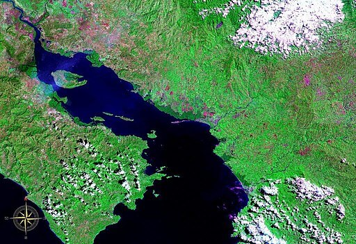
The Nicoya Peninsula and Gulf of Nicoya via NASA.