Saint Martin: One Island, Two Nations, and a World of Natural Wonders
Saint Martin is a small Caribbean island shared by France and the Netherlands. Settled by Arawak peoples, it has a history of colonial rivalry, plantations, and cultural mixing. Today, it features beaches, coral reefs, wetlands, and a vibrant culinary and cultural scene rooted in French, Dutch, and Caribbean influences.
 https://www.flickr.com/photos/24736216@N07/3925874461")
")
 https://www.flickr.com/photos/50144889@N08/16200332826")


 https://www.flickr.com/photos/terrazzo/22551344434")
")

 https://www.flickr.com/photos/96510847@N06/14018001754")
Saint Martin: A Caribbean Island Divided by History, United by Nature
In the northeastern Caribbean, where the Leeward Islands give way to open Atlantic waters, the island of Saint Martin occupies a singular place — politically divided yet geographically seamless, culturally layered yet unmistakably Caribbean. At just 87 square kilometres (34 square miles), it is one of the smallest landmasses in the world shared by two sovereign nations, yet it packs an extraordinary range of landscapes, languages, and living history into that modest footprint.
The northern portion belongs to France as the Collectivity of Saint-Martin, an overseas territory that is formally part of the European Union; the southern portion is Sint Maarten, a self-governing country within the Kingdom of the Netherlands. Together they form a single island of striking contrasts — where French bistros and open-air markets sit within easy driving distance of Dutch casinos and duty-free shopping strips, and where volcanic peaks and coral-fringed beaches coexist with some of the most visited anchorages in the Caribbean. Remarkably, the border between the two territories is entirely open, marked only by a modest monument, a testament to the enduring spirit of cooperation that has defined the island for nearly four centuries.
Geographic Setting
Saint Martin sits at the northern end of the Leeward Islands chain within the Lesser Antilles, positioned south of Anguilla across the narrow Anguilla Channel, and northwest of Saint Barthélemy. On clear days, the neighbouring Dutch islands of Saba and Sint Eustatius are visible on the horizon, as is the twin-island nation of Saint Kitts and Nevis — a reminder of how densely this corner of the Caribbean is populated with islands, each with its own distinct character and history.
The island spans roughly 19 kilometres (12 miles) in both its north-south and east-west dimensions. Its most distinctive geographic feature is the elongated sand spit that curves westward from the hilly interior, enclosing the vast Simpson Bay Lagoon from the open sea. Widely regarded as the largest enclosed body of water in the Caribbean, the lagoon stretches across the boundary between both territories and forms the heart of the island's sailing and boating culture. The division of the island between France and the Netherlands has been formalised since 1648, with the French side covering approximately 53 square kilometres (20 square miles) and Sint Maarten occupying roughly 34 square kilometres (13 square miles).

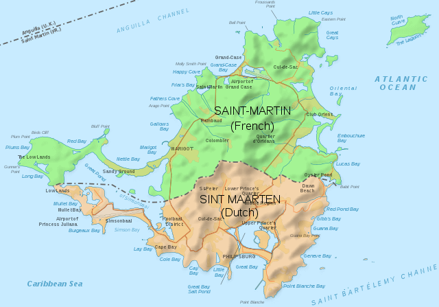
Saint Martin location map.
Topography and Landscapes
The island's terrain is predominantly hilly and volcanic, its rugged interior rising sharply from the coastline. The highest point, Pic Paradis on the French side, reaches 424 metres (1,391 feet) above sea level. On clear mornings, the summit offers sweeping views across both territories and far out to the surrounding islands — a perspective that makes Saint Martin's compact scale all the more striking. The slopes below are forested with dry tropical woodland, gradually giving way to scrubland and cactus-dotted hillsides at lower elevations, a vegetation pattern shaped by the island's position in the rain shadow of its own hills.
Saint Martin's coastline is remarkably varied. Rocky, coral-fringed headlands alternate with stretches of white and pale-gold sand, and sheltered bays create calm, turquoise-water anchorages that have attracted sailors for centuries. The sea grape (Coccoloba uvifera) and coconut palm (Cocos nucifera) are ubiquitous along the shoreline, their silhouettes forming the quintessential Caribbean backdrop. Inland, the landscape opens into low-lying wetlands, salt ponds, and brackish lagoons that represent some of the island's most ecologically productive habitats. Saint Martin has 37 named beaches in total, ranging from broad, surf-facing Atlantic stretches to calm, reef-protected coves on the Caribbean side — enough variety that even frequent visitors rarely see them all.
A Human History Written in Salt, Sugar, and Stone
Long before European ships appeared on the horizon, Saint Martin was home to successive waves of Indigenous settlement. Archaeological evidence dates the island's earliest inhabitants, likely belonging to the Ciboney — a subgroup of the Arawak people — to approximately 3,500 years ago. Around 800 AD, a further migration of Arawak-speaking peoples arrived from the Orinoco Basin of South America, establishing farming and fishing communities across the island. They knew it as Soualiga, meaning "Land of Salt," a name that referenced the extensive salt ponds scattered across the landscape and which would prove prophetic of the island's economic future. By the time European exploration reached the Lesser Antilles, the Arawak had largely been displaced by the Kalinago, a more militaristic people also originating in South America, who had been expanding northward through the island chain.
Christopher Columbus sighted the island on November 11, 1493, during his second voyage to the Americas, and named it Isla de San Martín in honour of Saint Martin of Tours, whose feast day fell on that date. Neither Columbus nor the Spanish made any immediate attempt to settle it, and for decades the island remained on the periphery of Spanish colonial ambitions. That changed when the Dutch recognised the island's strategic value as a midpoint between their colonies in New Amsterdam (present-day New York) and Brazil, and established a settlement there in 1631, building Fort Amsterdam as protection against rival powers. The Dutch West India Company quickly began extracting salt — then a vital commodity for preserving fish and meat across the Atlantic world — from the island's abundant pans.
Spain, unwilling to cede the position, captured Saint Martin from the Dutch in 1633 and held it for fifteen years, constructing their own fortification at Point Blanche. When the Eighty Years' War between Spain and the Netherlands finally ended in 1648, Spain found it had little further use for the island. The Dutch and French, each eager to reclaim a foothold, arrived simultaneously from their respective neighbouring colonies — the Dutch from Sint Eustatius, the French from Saint Kitts. Recognising that neither side would yield, they chose negotiation over conflict, signing the Treaty of Concordia on March 23, 1648. The agreement divided the island between them: the French retained the northern portion they occupied, and the Dutch kept the southern area around their former fort. Notably, the French negotiators had a fleet of warships anchored offshore as a bargaining tool, which may explain why France ended up with the larger share.
A more colourful — and almost certainly apocryphal — local legend attributes the border to a walking contest. A Frenchman and a Dutchman, starting back-to-back from the same point, were to walk the coastline in opposite directions, with the border drawn where they met. The French side explains its larger portion by claiming the Dutchman stopped to drink gin along the way; the Dutch counter that the Frenchman cheated by running. Whatever the truth, the border shifted sixteen times between 1648 and 1816, before settling permanently into its current alignment.
The island's plantation era left deep and painful marks. By the seventeenth and eighteenth centuries, some 92 plantations operated across both sides of the island, most cultivating sugar, with others focused on indigo, cotton, and livestock. Their operation depended entirely on enslaved labour, and the legacy of that system is woven into the island's cultural memory. The French side abolished slavery in 1848; the Dutch side followed in 1863. Even after emancipation, the hard labour of salt harvesting in the Great Salt Pond continued well into the twentieth century, a history commemorated today by the Salt Picker's Monument in Philipsburg. In 2010, the remains of three enslaved individuals from the seventeenth century — known as the "Zoutsteeg Three" — were discovered during construction works on Sint Maarten, and subsequent DNA analysis provided rare scientific insight into the origins and routes of the transatlantic slave trade.
Sint Maarten became one of the six constituent islands of the Netherlands Antilles in 1954, and when that political structure was dissolved in 2010, it became an autonomous country within the Kingdom of the Netherlands. The French side, meanwhile, separated from Guadeloupe in 2007 to become the independent Collectivity of Saint-Martin.
Map of the island of Saint Martin.
Culture, Language, and Identity
The island's cultural character is a product of its layered colonial history, shaped further by centuries of migration and trade. English is the most widely spoken language across both sides — a legacy, in part, of the many British-origin plantation owners who settled Sint Maarten in the eighteenth century at the invitation of Governor Philips (whose name lives on in the capital, Philipsburg). French is the official language of the northern collectivity, while Sint Maarten holds Dutch and English as co-official languages. Walk through any market or waterfront, and you are also likely to hear Spanish, Haitian Creole, and Papiamento — the Portuguese-Dutch-Spanish-African creole of the Dutch Caribbean islands of Aruba, Bonaire, and Curaçao — as well as the languages of more recent arrivals from India, the Dominican Republic, Guyana, and Jamaica. The island's residents sometimes cut through the naming complexity by simply referring to their home as SXM, after the IATA airport code for Princess Juliana International.
On the Dutch side, Philipsburg is a compact, colourful town built on a narrow strip of land between Great Bay and the Great Salt Pond. Its main street — known simply as Front Street — is lined with duty-free shops, jewellery stores, and rum producers. The most distinctive local spirit is guavaberry liqueur, produced from the wild guavaberry (Myrciaria floribunda), a small, tart fruit harvested from the island's hillsides and traditionally used to make a Christmas drink blended with rum. The Dutch side is also known for its casino culture, nightlife, and the Sint Maarten Carnival, one of the most exuberant in the region, held in late April and early May. The cultural calendar includes street parades, calypso competitions, and the crowning of a Carnival Queen in an event that draws visitors from across the Caribbean.
Marigot, the capital of the French collectivity, projects a markedly different character. Its waterfront market — particularly vibrant on Wednesday and Saturday mornings — spills over with local produce, spices, artisan goods, and the informal energy of a genuinely working Caribbean market town, rather than one performing itself for tourists. Above the town, Fort Saint-Louis, constructed in the late eighteenth century to defend the bay, offers one of the finest panoramic views on the island. The French side is also known for its restaurant culture, which blends classical French technique with Creole and South Asian Caribbean influences — the latter a legacy of migration from Guadeloupe and Martinique — and for the informal outdoor restaurants known locally as lolos, where grilled fish, chicken, and Creole rice dishes are served at roadside tables in an atmosphere that is as social as it is culinary.
Biodiversity and the Living Landscape
Despite its small size, Saint Martin supports a remarkable diversity of life across a range of interlocking ecosystems. The island has recorded approximately 522 wild plant species, and its varied habitats — from coastal mangrove forests to upland dry woodland — support an array of terrestrial and marine fauna. Among the plants, at least two species — Calyptranthes boldinghii and Galactia nummularia — are considered island endemics, though both are feared to be critically at risk, or possibly already lost.
The marine environment is particularly rich. Seagrass beds cover some 62 square kilometres (24 square miles) across the island's coastal waters, providing feeding grounds for green sea turtles (Chelonia mydas) and leopard rays, as well as nursery habitat for juvenile fish and molluscs, including the queen conch. Coral reefs ring much of the island in two main formations: fringing reefs in shallower inshore waters at around 10 metres (33 feet) depth, and barrier reefs further offshore at around 20 metres (66 feet), where greater depth supports a more diverse community of species. Surveys conducted by the Saint-Martin National Nature Reserve have recorded approximately 1,040 marine species in the reserve's waters, including around 30 coral species and more than 500 molluscs. Offshore, between January and May, humpback whales (Megaptera novaeangliae) gather in the shallow waters around the island during their mating season — one of the most spectacular and least-advertised wildlife spectacles in the Lesser Antilles.
The island's mangroves are dominated by the red mangrove (Rhizophora mangle), whose distinctive arching prop roots trap sediment, filter nutrients, and provide shelter for crabs, juvenile fish, and countless invertebrates. Around fifty bird species have been recorded in and around the nature reserve's wetland habitats, including brown pelicans, snowy egrets, great egrets, spotted sandpipers, and white-cheeked pintail ducks. Three species of sea turtle — the loggerhead (Caretta caretta), hawksbill (Eretmochelys imbricata), and leatherback (Dermochelys coriacea) — come ashore to nest on the island's eastern beaches and offshore islets.
The Saint-Martin National Nature Reserve, established in 1998 and covering 3,060 hectares (7,561 acres) across the northeastern French portion of the island, is the primary institutional guardian of this biodiversity. Its mandate covers five main ecosystems: coral reefs, mangroves, phanerogam seagrass beds, ponds, and coastal dry forest. The reserve's terrestrial section protects rocky coastline, cliffs, beaches, and small offshore islets, including Pinel, Green Cay, and Tintamarre, the last of which takes its name from the Spanish tinta mar, meaning "colour of the sea." An environmental police team patrols reserve waters to enforce restrictions on fishing, anchoring, jet-skiing, and other activities that can damage reef ecosystems. The reserve also attracts around 400,000 visitors annually, with an underwater discovery trail at Pinel Island allowing snorkellers to observe reef fish and coral without causing disturbance.
On the Dutch side, the Mullet Pond section of Simpson Bay Lagoon was designated a Ramsar Wetland of International Importance in 2016, recognising its mangrove forests as critical habitat for juvenile fish and a natural buffer against storm surge. The lagoon as a whole is the largest enclosed body of water in the Caribbean and provides anchorage for hundreds of yachts while also supporting the ecological systems that depend on its calm, nutrient-rich waters.
Climate, Hurricanes, and Resilience
Saint Martin has a tropical savanna climate, moderated by the northeast trade winds that keep temperatures relatively consistent throughout the year. The average annual mean temperature is 27.2°C (81°F), and sea surface temperatures closely mirror air temperatures, making the surrounding waters inviting year-round. Average annual rainfall is approximately 1,047 mm (41.2 inches), concentrated in the wetter season between August and December. January through April is the drier season and the peak period for tourism, when skies are reliably clear, and humidity is lower.
The island lies squarely within the Atlantic hurricane belt, and the season's risks — running June through November, with greatest intensity in August through October — are not abstract. In September 2017, Hurricane Irma made landfall as a Category 5 storm with sustained winds of around 295 kilometres per hour (185 miles per hour), one of the most powerful Atlantic hurricanes ever recorded. The damage was catastrophic: the vast majority of structures on both sides of the island were severely damaged or destroyed, some 7.4 hectares (18 acres) of mangrove forest were lost, and the island's infrastructure — roads, utilities, the airport — was rendered largely non-functional. Recovery was neither quick nor easy, but within two years, the private sector had rebuilt roughly two-thirds of pre-Irma hotel capacity, and public infrastructure reconstruction continued in subsequent years. The disaster accelerated serious discussion about building codes, coastal protection, and the ecological importance of mangroves as natural storm buffers — a conversation that continues as climate projections suggest more intense hurricanes in the coming decades.
Tourism and the Island Economy
Tourism is the dominant economic activity on both sides of Saint Martin, and has been since it began to develop in earnest in the 1960s and 1970s. The island draws visitors seeking a combination of beach relaxation, watersports, dining, duty-free shopping, and cultural exploration — all without the need to clear customs when crossing between territories. Its international airport, Princess Juliana International on the Dutch side, gained a devoted following among aviation enthusiasts for its approach path, which brings arriving aircraft on a low pass directly over Maho Beach. For decades, spectators gathered on the sand to experience the roar of descending jets at close range, a spectacle that became one of the most photographed aviation scenes in the world.
The island's 37 beaches cater to a wide range of tastes. Orient Bay on the French side is a long, lively stretch known for its beach bars, watersports, and famously clothing-optional sections. Maho Beach on the Dutch side draws the plane-spotting crowd. Dawn Beach, facing the Atlantic, is sought out by surfers and those who prefer a more exposed, energetic sea. The calmer, reef-sheltered bays of the Caribbean coast are popular with families and snorkellers. Inland, the hills around Pic Paradis offer hiking through dry forest and secondary woodland, with orchids, bromeliads, and the occasional green-throated Carib hummingbird (Eulampis holosericeus) as rewards for the climb.
Sailing is deeply embedded in the island's identity. Simpson Bay Lagoon provides one of the Caribbean's finest natural harbours, and the island hosts several annual regattas that draw competitive sailors from across the Atlantic world. Diving and snorkelling on the offshore reefs, exploring the underwater trail at Pinel Island, and boat trips to the small uninhabited islets of the nature reserve round out an outdoor offering that complements the island's more urban pleasures.
Saint Martin is, in many respects, a place that refuses easy categorisation. It is simultaneously European and Caribbean, French and Dutch, cosmopolitan and intimately small. Its history carries the full weight of Caribbean experience — Indigenous settlement, colonial conquest, the plantation system, emancipation, and the long process of building a society from many different origins. Its landscapes range from wave-battered Atlantic cliffs to glassy lagoon shores, and its reefs and wetlands support an ecological community of surprising richness for an island of its size. That complexity — historical, ecological, and human — is precisely what makes Saint Martin one of the most compelling and rewarding islands in the Lesser Antilles.