French Guiana: Natural Landscape
French Guiana (Guyane), an overseas territorial collectivity of France, is located on the northeastern Atlantic coast of South America. Almost the entire territory is covered by rainforest, and its many large rivers and streams constitute the only natural means of penetration into the interior.


, CC BY 2.5, via Wikimedia Commons")


 https://www.flickr.com/photos/deadmike/4387387977/in/photostream/")

The Natural Landscape of French Guiana
French Guiana (Guyane) is located on the northeastern Atlantic coast of South America and is bordered by Suriname to the west and Brazil to the east and south. Its coastline with the Atlantic Ocean in the north extends approximately 378 km (235 mi). It is highly biodiverse and mostly covered by dense, largely unexplored rainforest. Although rapids break their courses, its many large rivers and streams constitute the only natural means of penetration into the interior.
An overseas territorial collectivity of France, French Guiana's capital is Cayenne. It is part of the region known as "The Guianas," which includes Guyana and Suriname. With a land area of 83,534 sq km (32,253 sq mi), it is mainland South America's smallest country or territory.
French Guiana is sometimes considered part of the Caribbean South America subregion, along with the other Caribbean Sea boundary nations of South America: Colombia, Venezuela, Suriname, and Guyana. Its population, most of whom live along the coast, is ethnically diverse. Guianese Creoles (people of primarily African heritage mixed with some French ancestry) are the largest ethnic group.
According to research estimates, indigenous peoples make up approximately 4% of Guiana's population or more than 10,000 individuals. Six indigenous communities survived colonization: the Kali'na Tileuyu, Lokono, and Pahikweneh, who live on the coast near the urban centers and the Wayãpi, Teko, and Wayana people, who live in isolated territories in the headwaters of the Oyapock and Maroni rivers.
Biodiversity
French Guiana is a bastion of biodiversity, owing to its expansive old-growth forests serving as biodiversity hotspots. The rainforests here harbor an array of flora and fauna and provide vital shelter for numerous species.
The recorded biodiversity is impressive, with over 5,500 plant species, including 1,000 trees, and a diverse fauna encompassing 700 bird species, 177 mammal species, over 500 fish species (45% of which are endemic), and 109 amphibian species. Notable wildlife residents include pumas, monkeys, tapirs, caimans, ocelots, sloths, great anteaters, capybaras, and armadillos.
Conservation
Conservation in French Guiana is a continual and essential undertaking, aiming to protect the region's distinctive biodiversity, pristine ecosystems, and natural resources. The vast expanses of undisturbed rainforests, wetlands, and coastal environments make French Guiana an environmental treasure.
Numerous protected areas, such as national parks, nature reserves, and wildlife sanctuaries, cover a significant portion of the land and marine territory. Key among them are the Guiana Amazonian Park (Parc Amazonien de Guyane) and the Maroni River Nature Reserve.
Despite these conservation endeavors, the region faces challenges like illegal mining, deforestation, habitat degradation, and the socio-economic factors that drive these activities. French Guiana, however, remains steadfast in its commitment to conserving its biodiversity, balancing the needs of sustainable development with the imperative of environmental preservation.
Climate
French Guiana boasts a tropical climate, featuring warm temperatures and elevated humidity throughout the year. The average temperature hovers around 27 °C (81 °F), with humidity averaging 85%. This climate unfolds in two distinct seasons: the wet season and the dry season.
The wet season spans from December to July, marked by substantial rainfall, with averages exceeding 3,000 mm (118 in). Conversely, the dry season prevails from August to November, with reduced rainfall and lower humidity. Nevertheless, even during the dry season, some precipitation graces the region.
Regional nuances add a layer of diversity to the climate. Coastal areas tend to be warmer and more humid than the interior, while the southern mountains exhibit cooler and less humid conditions. This variation underscores the intricate climatic mosaic that defines French Guiana's tropical landscape.
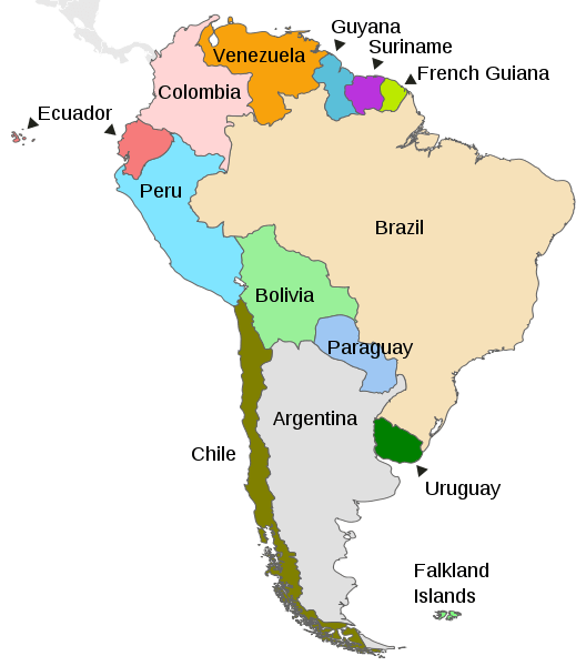
Map depicting the countries on the continent of South America
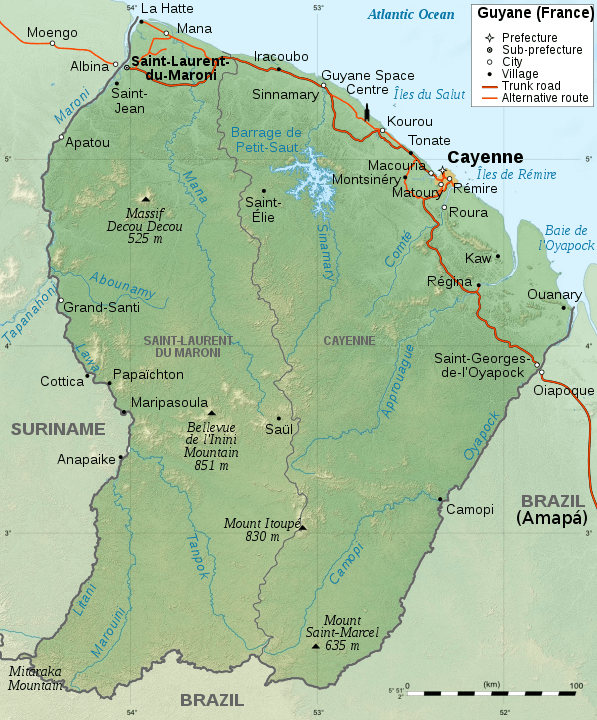
Natural Geography of French Guiana
Geographic Regions (Zones)
French Guiana's diverse terrain can be divided into two primary geographical regions or zones:
-
Coastal Strip: Located in the north along the coast, this coastal strip is home to most of the population. Known as the "Terres Basses" (lowlands), it is a small, low, and swampy coastal area with a width varying from 10 to 30 km (6 - 19 mi).
-
Interior Region: Comprising the expansive interior, this region is defined by a granite peneplain called the "Terres Hautes" (highlands). Erosion has shaped it into steps, forming a series of low, steep hills.
Dense, largely unexplored rainforests predominantly cover French Guiana's landscape. The rainforests are crisscrossed by numerous large rivers and streams punctuated by rapids. These waterways are the primary natural means of penetration into the interior.
The Tumuc Humac Mountains, located near the Brazilian border, are an important geographic feature. They are an eastern extension of the Acarai Mountains and are part of the northern watershed of the Amazon River basin. The mountains add a distinct elevation to the southern landscape, creating a geographical contrast that defines the captivating blend of French Guiana's coastal lowlands, interior highlands, and the impressive Tumuc Humac Mountains.
Geographic map of French Guiana
Natural Features
Barrage de Petit-Saut: The Barrage de Petit-Saut gravity dam, situated approximately 36 km (22 mi) south of Sinnamary along the Sinnamary River, creates an artificial lake, contributing to hydroelectricity generation.
Islands:
-
Salvation Islands (Îles du Salut): This group, positioned around 11 km (7 mi) off the Atlantic coast, encompasses Devil's Island, Royale Island, and Saint-Joseph Island.
-
Constable Islands (Îles du Connétable): Grand Connétable and Petit Connétable, located approximately 18 km (11 mi) offshore from the Approuague estuary, are integral components of the Île du Grand Connétable Nature Reserve.
Mountain Peaks: French Guiana showcases notable mountain peaks, adding elevation to its landscape:
- Mont Bellevue de l'Inini: 851 m (2,792 ft)
- Mont Machalou: 782 m (2,566 ft)
- Pic Coudreau: 711 m (2,333 ft)
- Mont St Marcel: 635 m (2,083 ft)
- Mont Favard: 200 m (656 ft)
- Montagne du Mahury: 156 m (512 ft)
These natural features contribute to the geographical diversity of French Guiana, encompassing dams, islands, and mountain peaks that collectively define the region's captivating landscape.
Bodies of Water
French Guiana hosts diverse bodies of water, contributing to its unique ecological and cultural landscape. These water bodies are essential in supporting local communities, sustaining biodiversity, and providing opportunities for ecotourism, fishing, and other recreational activities.
See: Water Bodies of French Guiana
Administrative Divisions
French Guiana is divided into three arrondissements, and each is subdivided into a total of 22 cantons.
See more: Cultural Landscape of French Guiana
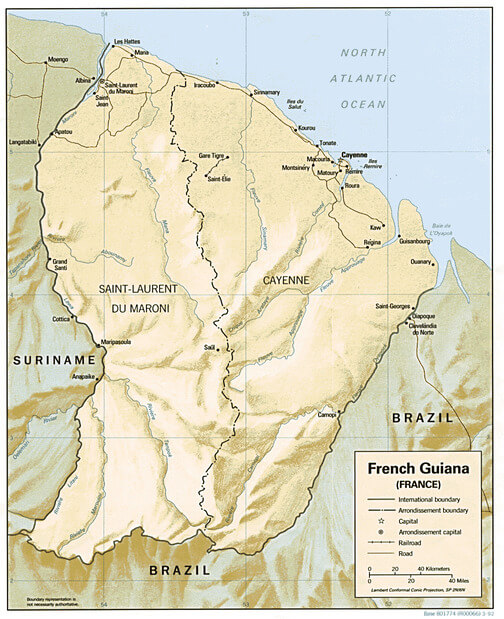
Relief map of French Guiana
Natural Regions
French Guiana has many ecosystems: tropical rainforests, coastal mangroves, savannahs, inselbergs (isolated hills), and wetlands. In addition, it lies within three ecoregions.
Ecological Regions
The following is a list of terrestrial ecoregions in French Guiana, as defined by the World Wide Fund for Nature (WWF). French Guiana is in the Neotropical realm. Ecoregions are classified by biome type - the major global plant communities determined by rainfall and climate.
Tropical and subtropical moist broadleaf forests
Mangroves
-
Guianan mangroves
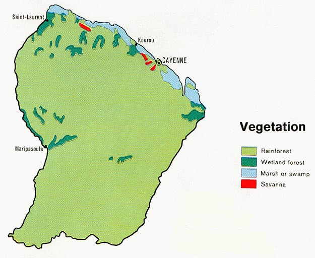
Vegetation map of French Guiana