
Rio Grande / Río Bravo del Norte: A River, Two Names, One Shared Story
Known as the Rio Grande in the United States and the Río Bravo del Norte in Mexico, this river runs from Colorado's San Juan Mountains to the Gulf of Mexico and forms the international border. This overview treats the whole river and both nations' relationships to it equally, alongside a dedicated article covering its course through Mexico in greater depth.
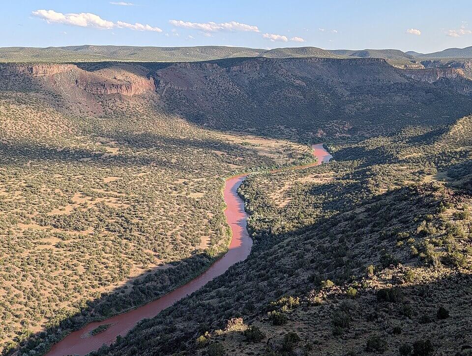
The River That Divides and Sustains: Rio Grande / Río Bravo del Norte
Few rivers on Earth carry two entirely different names for two entirely different nations, yet remain, geographically and hydrologically, a single continuous system. In the United States, it is the Rio Grande. In Mexico, it is the Río Bravo del Norte, or simply Río Bravo. Both names describe the same river: a 3,051-km (1,896-mi) waterway that rises in the high peaks of southern Colorado and flows to the Gulf of Mexico, forming, for roughly 2,000 km (1,240 mi) of its length, the international boundary between the United States and Mexico. This article treats the river as a single, shared system, its geography, its history, and its significance to both nations, without favoring either country's name or perspective; dedicated articles cover the river's course through Mexico and, in more depth, its course through the United States.
A River, Two Names
The river's naming history reflects centuries of shifting claims and cultures along its banks. The Pueblo peoples of what is now New Mexico called it Posoge, "big river," long before European contact. Spanish expeditions in the 16th century assigned it several different names in succession, including Río de Nuestra Señora and Río Guadalquivir, before the name Río Bravo, meaning wild, bold, or turbulent rather than simply "brave," came into use for the river's lower course by around 1598. "Rio Grande," Spanish for "great river," became the dominant English-language name for the river's upper and middle course in the United States. At the same time, "Río Bravo del Norte" remained, and remains, the name used throughout Mexico for the river's entire length. Neither name is more correct than the other; they are simply the names each nation settled on for the same river, and this site follows that same duality rather than choosing a single winner.
From the Rockies to the Gulf
The river's journey begins at over 3,700 m (12,000 ft) above sea level at Stony Pass in Colorado's San Juan Mountains, part of the southern Rocky Mountains, where snowmelt gathers into a clear mountain stream at the Continental Divide. From there it flows south through Colorado's San Luis Valley, one of the largest high-altitude desert basins in the world, before entering New Mexico and carving through the dramatic Rio Grande Gorge near Taos, a rift valley deep enough to be spanned by one of the highest bridges in the United States. Continuing south, the river irrigates the broad agricultural valley around Albuquerque before reaching El Paso, Texas, and Ciudad Juárez, Chihuahua, together the largest binational metropolitan area anywhere along the border, with a combined population well over 2.7 million people.
Below El Paso, the river's character changes markedly. So much water is withdrawn for irrigation above this point that the riverbed itself frequently runs dry through the El Paso valley in all but the wettest years; the river effectively restarts as a perennial stream only where Mexico's Río Conchos, its single largest tributary, joins it at Presidio, Texas, and Ojinaga, Chihuahua. From there, the river carves through the three dramatic canyons of the Big Bend region, Santa Elena, Mariscal, and Boquillas, protected on the US side by Big Bend National Park and on the Mexican side by a complex of protected areas including Cañón de Santa Elena and Maderas del Carmen. Further downstream, two large binational reservoirs, Amistad Reservoir near Del Rio, Texas, and Ciudad Acuña, Coahuila, and Falcon Reservoir near Laredo, Texas, and Nuevo Laredo, Tamaulipas, store water for both countries before the river winds through the fertile Rio Grande Valley of South Texas and Tamaulipas and finally reaches the Gulf of Mexico at Boca Chica, near Brownsville, Texas, and Bagdad, Tamaulipas.
A Watershed Shared by Two Nations
The river's total drainage basin covers approximately 472,000 sq km (182,000 sq mi) across one US state, Texas, along with Colorado and New Mexico further upstream, and four Mexican states: Chihuahua, Coahuila, Nuevo León, and Tamaulipas. Major tributaries feed the system from both sides of the border, including the Pecos and Devils rivers in Texas and the Río Conchos and Río San Juan in Mexico, the latter of which sustains the water supply of Monterrey, one of Mexico's largest cities, via the El Cuchillo Dam well outside the immediate river corridor. This binational drainage means that decisions made far from the river itself, in the mountains of Colorado or the interior of Chihuahua, directly shape how much water ultimately reaches the border communities and ecosystems downstream.
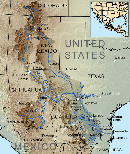
Map depicting the Rio Grande/Río Bravo del Norte and its tributaries within its drainage basin.
Treaties and Shared Management
Given how thoroughly the river's waters are shared, and how heavily both nations depend on them, the United States and Mexico have managed the river jointly for well over a century. The 1906 Convention first established a fixed annual allocation of the river's upper waters to Mexico near El Paso, while the more comprehensive 1944 Water Treaty extended binational management downstream, allocating the flows of the lower river and establishing reciprocal water-delivery obligations between the two countries that remain in effect today. The treaty is administered jointly by the International Boundary and Water Commission on the US side and the Comisión Internacional de Límites y Aguas on the Mexican side, sister agencies that coordinate reservoir operations, water quality monitoring, and boundary maintenance along the entire river.
A River Under Strain
Despite this longstanding cooperative framework, the river faces serious and worsening strain. Roughly 80% of the water withdrawn from the Rio Grande/Río Bravo system is used for irrigation on both sides of the border. Combined with a warming, increasingly drought-prone climate, this has pushed the river to a breaking point at its own mouth: in mid-2001, for the first time in recorded history, the river failed to reach the Gulf of Mexico at all, blocked by a sandbar that had built up across its mouth, a direct consequence of upstream withdrawal outpacing the river's flow. The sandbar has since reformed intermittently in subsequent dry years. The World Wildlife Fund has listed the Rio Grande/Río Bravo among the ten most endangered rivers in the world, and species such as the Rio Grande silvery minnow (Hybognathus amarus), whose range has collapsed by over 95% across the river system, illustrate the ecological cost of that strain. At the same time, the river corridor remains a critical wildlife corridor and migratory bird route, sitting at the meeting point of the Central and Mississippi flyways used by hundreds of bird species each year, underscoring how much still depends on a river that no longer reliably reaches the sea.
One River, Shared Between Two Nations
The Rio Grande/Río Bravo del Norte is, in the end, a single physical river that two nations have shaped, named, and depended upon in distinct ways. Its course through Mexico, including the Río Conchos watershed, the maquiladora cities of the border, and Mexico's own conservation and water-management challenges, is covered in greater depth in our Río Bravo del Norte article. Read together, the two pieces are meant to reflect the river as it actually exists: one continuous system, understood from more than one vantage point, belonging fully to neither nation's story alone.