The Tiburon Peninsula: Haiti's Rugged and Biodiverse Jewel
The Tiburon Peninsula, or Xaragua Peninsula, stretches westward from Haiti's southernmost point into the Caribbean Sea. Renowned for its rugged terrain, lush rainforests, and pristine beaches, the remote and sparsely populated region embodies Haiti's natural beauty and biodiversity.


Haiti's Mountainous Wilderness: Exploring the Tiburon Peninsula
The Tiburon Peninsula, also known as the Xaragua Peninsula, stretches westward from the southernmost point of Haiti into the Caribbean Sea. Renowned for its rugged terrain, lush rainforests, and pristine beaches, the Tiburon Peninsula is a remote and sparsely populated region that embodies Haiti's natural beauty and biodiversity. Despite its challenges, including poverty and vulnerability to natural disasters, the peninsula remains a vital cultural and ecologically significant area, offering a unique glimpse into the country's diverse landscapes.
Geographic and Demographic Overview
The Caribbean Sea borders the Tiburon Peninsula to the north and the Gulf of Gonâve to the south. This mountainous region encompasses three of Haiti's departments: Grand'Anse, Nippes, and Sud, with a portion of the Sud-Est department extending into the peninsula. The peninsula's population is approximately 1.5 million, with most residents living in rural areas and depending on agriculture and fishing for their livelihoods.
The region is characterized by its rugged, mountainous terrain, which includes part of the Massif de la Hotte mountain range, an extension of the larger Massif de la Selle that runs through eastern Haiti. The highest point on the peninsula is Pic Macaya, which reaches about 2,347 meters (7,700 feet) above sea level. This peak is located within Pic Macaya National Park, a crucial area for preserving the peninsula's natural beauty and biodiversity.
While the mountainous interior is sparsely populated, several towns and communities thrive along the coast. Les Cayes, one of Haiti's largest cities, serves as the capital of the Sud department and is a major port city and agricultural center. Jérémie, the capital of the Grand'Anse department, is a charming coastal town known for its well-preserved colonial architecture. Miragoâne, the capital of the Nippes department, is a bustling market town and a hub for coffee production. These coastal communities and many smaller fishing villages contribute to the peninsula's cultural and economic vibrancy.
Biodiversity and Environmental Significance
The Tiburon Peninsula is a biodiversity hotspot, home to unique and diverse ecosystems ranging from dry forests to cloud forests in the higher elevations. The region's flora and fauna are remarkable for their diversity, with numerous endemic plant and animal species found nowhere else on Earth. The peninsula's tropical climate, characterized by distinct wet and dry seasons, contributes to this rich biodiversity. While the region is one of the drier areas of Haiti, the mountainous regions receive more rainfall, resulting in lush tropical vegetation and forests that support a variety of wildlife.
Pic Macaya National Park, situated on the peninsula, is a focal point for conservation efforts in Haiti. The park is critical in protecting endangered species, such as the critically endangered La Selle leaf-toed gecko (Phyllodactylus laesellii). The park's diverse ecosystems, ranging from lowland forests to cloud forests, provide habitats for a wide range of species, including monkeys, snakes, and crocodiles. Preserving these habitats is essential for maintaining the peninsula's ecological balance and protecting its unique biodiversity.
Socio-Economic Challenges and Opportunities
Despite its natural beauty and ecological significance, the Tiburon Peninsula faces numerous socio-economic challenges. The region is characterized by widespread poverty, limited access to healthcare and education, and vulnerability to natural disasters, including hurricanes. Many of the peninsula's inhabitants rely on subsistence farming, and the lack of infrastructure and economic opportunities has hindered development in the area.
However, there are also opportunities for sustainable development on the peninsula. Eco-tourism, for example, has the potential to provide a source of income for local communities while promoting the conservation of the region's natural resources. The establishment of Pic Macaya National Park and other conservation initiatives have already begun to attract visitors interested in exploring the peninsula's unique ecosystems and biodiversity. Additionally, efforts to improve agricultural practices and support local industries, such as fishing and coffee production, could help boost the region's economy and improve the quality of life for its residents.
Cultural and Historical Significance
The Tiburon Peninsula is not only significant for its natural beauty but also for its cultural and historical heritage. The region is dotted with small towns and villages that retain a strong cultural identity, with traditions and customs passed down through generations. The coastal town of Jérémie, in particular, is known for its colonial architecture and rich cultural history. As the birthplace of several prominent Haitian poets and writers, Jérémie is often called the "City of Poets."
The peninsula's history is also intertwined with Haiti's broader national history. The region was once part of the Taino chiefdom of Xaragua, one of the five chiefdoms that existed on the island of Hispaniola before the arrival of Europeans. The legacy of the Taino people, along with the influence of African and European cultures, has shaped the cultural landscape of the Tiburon Peninsula, making it a region of profound historical significance.
Conservation and Future Prospects
The conservation of the Tiburon Peninsula's natural and cultural heritage is crucial for the region's future. Establishing Pic Macaya National Park and other conservation areas has significantly protected the peninsula's biodiversity. However, continued efforts are needed to address the region's challenges, including deforestation, habitat loss, and the impacts of climate change.
Sustainable development initiatives prioritizing conserving natural resources while supporting local communities are essential for preserving the peninsula's unique ecosystems and cultural heritage. By promoting eco-tourism, improving infrastructure, and supporting local industries, the Tiburon Peninsula can continue to be a place of natural beauty and cultural significance for future generations.
Conclusion
The Tiburon Peninsula is a testament to Haiti's natural and cultural richness of Haiti. From its rugged mountains and lush rainforests to its vibrant coastal communities and rich cultural heritage, the peninsula offers a unique and invaluable glimpse into the country's diverse landscapes and history of the country. Despite its challenges, the Tiburon Peninsula remains a region of great importance, both for its ecological significance and the cultural legacy it preserves. As efforts to conserve and develop the region continue, the Tiburon Peninsula will remain vital to Haiti's natural and cultural heritage.
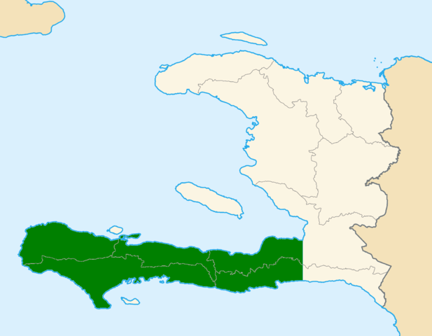
Location of the Tiburon Peninsula in Haiti, shaded in green.
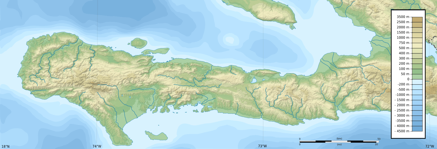
Topographic map of Tiburon Peninsula, Haiti.