The Massif de la Hotte and La Hotte Biosphere Reserve: Guardians of Biodiversity
The Massif de la Hotte, situated in southwestern Haiti on the Tiburon Peninsula, is renowned for its rugged terrain, unique biodiversity, and critical ecological role. The La Hotte Biosphere Reserve further highlights the region's importance as a biodiversity hotspot.


 https://www.flickr.com/photos/48858041@N05/12835794533")
 https://www.flickr.com/photos/48858041@N05/12836148934")
 https://www.flickr.com/photos/48858041@N05/12835723235")
 https://www.flickr.com/photos/48858041@N05/12835717565/")
Preserving Haiti's Natural Heritage: The Massif de la Hotte
The Massif de la Hotte, situated in southwestern Haiti on the Tiburon Peninsula, represents one of the most ecologically and historically significant regions on the island of Hispaniola. As the western extension of the Massif de la Selle mountain range in Haiti and the Sierra de Baoruco mountain range in the Dominican Republic, it is renowned for its rugged terrain, unique biodiversity, and critical ecological role. The La Hotte Biosphere Reserve, encompassing terrestrial and marine areas, further highlights the region's importance as a biodiversity hotspot and a center for conservation efforts.
Geographic and Geological Significance
Formation and Isolation
Approximately 2.5 million years ago, the Massif de la Hotte was isolated from the rest of Haiti by a deep sea channel. This isolation led to the evolution of unique and endemic species, creating a hotbed of biodiversity, particularly in its bird, plant, and reptile communities. The Massif de la Hotte's geological history has thus played a pivotal role in shaping its current ecological landscape.
Macaya Mountain Range
The Macaya Mountain Range, the most extensive range within the Massif de la Hotte, is a significant biodiversity hotspot in Haiti. The range comprises two east-west oriented ridges, Morne Formon and Morne Macaya, connected by a saddle. Pic Macaya, the highest peak in the range, rises to approximately 2,347 meters (7,700 feet) above sea level, making it the second-highest mountain in Haiti and the fifth-highest in the Caribbean. The Cayes Plain, located southeast of Pic Macaya, further enriches the region's ecological diversity with its dense cloud forests and varied habitats.
La Hotte Biosphere Reserve
Ecological Importance
The La Hotte Biosphere Reserve, encompassing terrestrial and marine areas, is a testament to the region's ecological richness. The reserve includes six mountain peaks and coastal marine and mangrove ecosystems, such as the Iles Cayemites in the north and Ile-à-Vache in the south. The reserve's wide range of climates, from humid to subtropical dry, contributes to its status as a biodiversity hotspot.
Pic Macaya National Park
At the core of the La Hotte Biosphere Reserve lies Pic Macaya National Park, which was established to conserve the ecosystem, landscape, biodiversity, and cultural values. The park serves as a vital area for research and education, highlighting the importance of conservation efforts in maintaining the region's high biodiversity.
Flora and Fauna
Vegetation and Endemic Species
The vegetation within the Massif de la Hotte serves as a crucial habitat for numerous endemic species. The karst forests, in particular, support a variety of orchids (Lepanthes and Lepanthopsis), bromeliads, lichens, and bryophytes. The region's rain frogs (Eleutherodactylus) are also endemic, showcasing the unique evolutionary pathways fostered by the area's isolation.
Aquatic and Avian Life
The La Hotte Biosphere Reserve is home to diverse freshwater and marine fish species, including two species of Tilapia, common carp, and the native Limia. Marine species such as the ball anemone, rock boring urchin, and various octopus species inhabit the waters of the southern peninsula. Avifauna in the region includes notable species like the Hispaniolan emerald, the spotted sandpiper, and the Hispaniolan boa, further emphasizing the reserve's ecological significance.
Socio-Economic and Historical Context
Population and Economic Activities
The reserve is home to approximately 855,000 people whose main economic activities include farming, agriculture, agroforestry, fisheries, commerce, handicrafts, and tourism. These activities are integral to the livelihoods of local communities and highlight the need for sustainable practices to balance economic development with conservation efforts.
Historical Significance
The Massif de la Hotte and the surrounding areas of Pic Macaya National Park have a rich historical legacy. During slavery, the region served as a refuge for maroons and later as a strategic base for insurgents during the wars of independence. Historical remains in the area bear witness to its crucial role in Haiti's struggle for freedom and the resilience of its people.
Conservation Challenges and Efforts
The Massif de la Hotte and La Hotte Biosphere Reserve face several challenges, including deforestation, climate change, and socio-economic pressures. These threats endanger the region's unique biodiversity and the well-being of local communities. However, various conservation initiatives are underway to address these issues. Efforts include reforestation projects, sustainable agricultural practices, and environmental education programs aimed at preserving the region's natural and cultural heritage of the region.
Conclusion
The Massif de la Hotte and La Hotte Biosphere Reserve are invaluable assets to Haiti and the world, offering a unique blend of ecological diversity, historical significance, and socio-economic potential. Their conservation is vital for maintaining the region's rich biodiversity and cultural heritage. By addressing their challenges and promoting sustainable development, the Massif de la Hotte and La Hotte Biosphere Reserve can continue to thrive and contribute to Haiti's natural and cultural legacy.
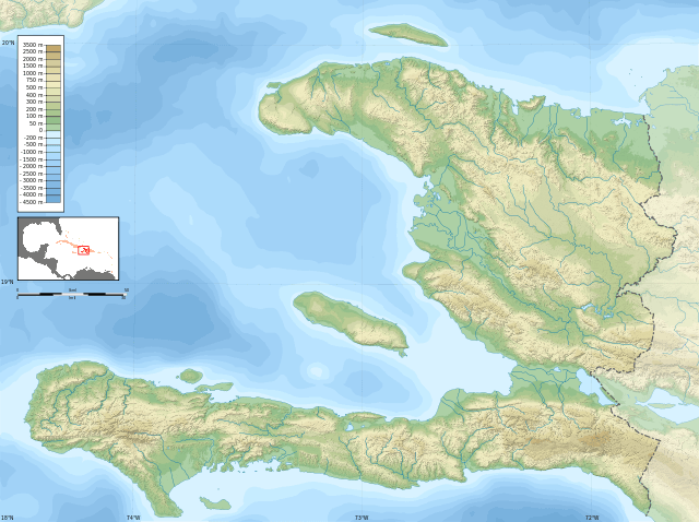
Topographic map of Haiti. The Massif de la Hotte is on the lower left.