Belize's Comprehensive Water Landscape: From Mountains to Reef
Belize uniquely combines terrestrial and marine environments, where ancient Maya rivers meet the world's second-largest barrier reef. This small nation boasts a diverse array of aquatic landscapes, ranging from mountain streams and rainforests to expansive coastal lagoons teeming with wildlife.


. - by I, Ondřej Žváček, CC BY-SA 3.0, via Wikimedia Commons")


 https://www.flickr.com/photos/91008793@N00/35974093091")
Jewel of the Caribbean: The Aquatic Treasures of Belize
Belize, positioned along the eastern coast of Central America, represents a unique confluence of terrestrial and marine environments where ancient Maya rivers meet the world's second-largest barrier reef system. This small nation, spanning 22,966 km² (8,867 sq mi), encompasses an extraordinary diversity of aquatic landscapes, from crystalline mountain streams cascading through pristine rainforests to expansive coastal lagoons teeming with wildlife. The country's water bodies serve as vital ecological corridors, economic lifelines, and cultural touchstones that connect the interior highlands to the Caribbean Sea while supporting both Indigenous communities and modern settlements across six districts.
Coastal Waters and Marine Environment
Belize commands one of the most spectacular marine environments in the Western Hemisphere, with a coastline extending approximately 386 km (240 mi) along the Caribbean Sea. The nation's territorial waters encompass a complex archipelago of cayes, atolls, and reef systems that form part of the Mesoamerican Barrier Reef System, creating a marine wonderland of global significance.
The Belize Barrier Reef, stretching over 300 km (186 mi) along the coast, ranks as the second-longest coral reef system in the world. This living barrier creates protected inshore waters that support diverse marine ecosystems while providing natural protection against hurricanes and storm surges. Between the mainland and the barrier reef lies a shallow lagoon system dotted with hundreds of mangrove cayes that serve as nursery grounds for countless marine species.
Offshore Atolls and Cayes
Belize claims an exclusive economic zone of 35,351 km² (13,649 sq mi) extending 200 nautical miles (370 km) from its coast, encompassing three of the four coral atolls in the Caribbean. Turneffe Atoll, the largest coral atoll in Belize and the Caribbean, covers approximately 531 km² (205 sq mi) of marine area. Lighthouse Reef Atoll features the famous Blue Hole, a circular marine sinkhole measuring 304 m (997 ft) across and 124 m (407 ft) deep. Glover's Reef Atoll, designated as both a UNESCO World Heritage site and marine reserve, provides critical habitat for endangered species and supports sustainable fishing practices.
The coastal waters between these atolls and the mainland host hundreds of cayes, ranging from tiny mangrove patches to substantial islands that support tourism infrastructure. These cayes create a complex network of channels, lagoons, and protected waters that support artisanal fishing, tourism, and marine conservation efforts.
The Belize Barrier Reef Reserve System, designated as a UNESCO World Heritage Site in 1996, encompasses seven protected areas covering 96,300 hectares (963 km²) of marine and coastal environments. This comprehensive reserve system includes the three offshore atolls, portions of the barrier reef, and associated coastal and marine ecosystems. The reserve system represents the most significant component of the Mesoamerican Reef System within Belizean waters and serves as a model for integrated marine protected area management. Through strict regulations and community-based conservation programs, the reserve system protects critical spawning grounds, nursery areas, and feeding habitats while supporting sustainable tourism and fishing activities that benefit local communities.
River Systems: Ancient Waterways Through Time
Belize contains 35 major and minor river catchments or watersheds that drain into the Caribbean Sea, creating a comprehensive network of freshwater systems that traverse the country from the Maya Mountains to the coast. These rivers have served as transportation corridors for millennia, supporting Maya civilization and continuing to provide essential resources for modern communities.
The Belize River: National Lifeline
The Belize River rises in northeastern Guatemala as the Río Mopán and flows approximately 290 km (180 mi) northeast through Benque Viejo and San Ignacio before emptying into the Caribbean Sea at Belize City. As the country's most significant waterway, the Belize River and its tributaries drain much of the nation's central region, supporting the largest population centers and most intensive agricultural activities.
The river system consists of two main branches: the Mopan River, which originates in Guatemala's Petén region, and the Macal River, which flows northward from the Maya Mountains. These branches converge near San Ignacio to form the main Belize River, which then meanders through the coastal plain before reaching the sea. Along its course, the river supports diverse ecosystems from mountain pine ridges and broadleaf forests to coastal wetlands and mangrove systems.
Historically, the Belize River served as the primary transportation route for the export of logwood and mahogany during the colonial period. Today, it continues to support agriculture, provides water supply for communities, and offers recreational opportunities, including river tours that showcase wildlife and archaeological sites.
Northern Watershed Systems
The Hondo River, approximately 150 km (93 mi) long, flows northeasterly to discharge into Chetumal Bay, forming most of the international border between Mexico and Belize. This river system drains the northern lowlands, supporting extensive wetland ecosystems and providing habitat for a diverse array of wildlife populations. The Hondo River region features some of Belize's most important archaeological sites, including the ancient Maya city of Cerros.
The New River flows through northern Belize near the ancient Maya city of Lamanai, providing access to one of the country's most significant archaeological sites. The New River Lagoon represents the country's largest lake, spanning approximately 13.5 km² (5.2 sq mi), and supports both ecological functions and tourism activities centered around Maya heritage sites.
Central River Systems
The Sibun River originates in the Maya Mountains at approximately 800 m (2,625 ft) above sea level and travels over 80 km (50 mi) through dense jungle, highways, and small villages before reaching the Caribbean Sea near Belize City. Known upstream as the Caves Branch River, this system supports adventure tourism activities, including cave tubing and provides essential ecosystem services for central Belize.
The Manatee River flows through the central coastal region, supporting important manatee populations and mangrove ecosystems. This river system provides critical habitat for the endangered West Indian manatee and serves as a model for marine mammal conservation efforts.
Southern River Networks
The Sarstoon River, measuring 111 km (69 mi) in length, forms the international border between Belize and Guatemala along the country's southern boundary. Rising in Guatemala's Alta Verapaz Department, this river supports diverse ecosystems and provides important habitat for both terrestrial and aquatic species.
The Monkey River in southeastern Belize represents one of the country's most pristine watershed systems. The river forms approximately 16 km upstream from its mouth, where the Bladen Branch joins other watercourses draining the eastern slopes of the Maya Mountains. This river system supports howler monkey populations, a diverse array of bird species, and traditional fishing communities.
The Grande River and Temash River systems drain the far south, supporting some of Belize's most intact rainforest ecosystems and Indigenous communities. These rivers provide essential habitat for jaguars, tapirs, and other endangered species while supporting traditional subsistence activities.
Inland Water Bodies and Lagoon Systems
While Belize lacks large natural lakes, the country features numerous lagoons, seasonal wetlands, and small water bodies that provide critical ecological functions. The Northern and Southern Lagoons, located south of Belize City near the coast, create important brackish water environments that support diverse fish and bird populations.
Coastal Lagoon Networks
The extensive mangrove lagoon systems along Belize's coast create complex aquatic environments that serve as nursery areas for marine species, feeding grounds for resident and migratory birds, and natural barriers against coastal erosion. These lagoons support traditional fishing activities while providing ecosystem services, including water filtration and carbon sequestration.
Seasonal flooding during the wet season creates temporary wetlands throughout the coastal plain, which support migratory waterfowl and provide breeding habitats for amphibians and other wildlife. These ephemeral water bodies play crucial roles in maintaining regional biodiversity and ecosystem connectivity.
Water Resources and Management Challenges
Belize's abundant freshwater resources face increasing pressures from population growth, tourism development, agricultural expansion, and climate change. The country's tropical climate provides substantial annual rainfall, but seasonal variations create periods of both abundance and scarcity that require careful management.
Water Quality and Conservation
Agricultural runoff, particularly from citrus and sugar cane operations, threatens water quality in major river systems. Coastal development and tourism infrastructure generate additional pressures on both freshwater and marine resources. Mining activities, though limited, create localized concerns about water contamination and ecosystem disruption.
Conservation efforts focus on protecting watershed forests, establishing riparian buffers, and implementing sustainable land use practices. The country's extensive protected area system, covering over 36% of the national territory, helps safeguard critical watersheds and maintains ecosystem integrity.
Climate Change Impacts
Rising sea levels threaten coastal communities, low-lying cayes, and mangrove ecosystems that depend on specific salinity gradients. Changing precipitation patterns may alter river flows and impact seasonal flooding cycles, which in turn support biodiversity and agricultural systems. Increased hurricane intensity poses growing risks to both marine and freshwater environments.
Adaptation strategies include improving coastal protection through mangrove restoration, developing climate-resilient agricultural practices, and enhancing water storage capacity to address seasonal variations. Early warning systems help communities prepare for extreme weather events, reducing their vulnerability to flooding and drought.
Economic and Cultural Dimensions
Belize's water bodies support a diverse range of economic activities that provide livelihoods for a significant portion of the population. Marine fisheries contribute significantly to both domestic food security and export earnings, with lobster, conch, and finfish supporting coastal communities. Aquaculture operations, particularly shrimp farming, provide additional sources of protein and income.
Tourism and Recreation
The country's spectacular marine environment attracts hundreds of thousands of visitors annually, generating crucial foreign exchange and supporting employment throughout the tourism sector. Diving, snorkeling, fishing, and marine wildlife viewing provide diverse recreational opportunities that showcase Belize's aquatic treasures to international visitors.
River-based tourism offers a range of complementary experiences, including archaeological site visits, wildlife observation, and adventure activities such as cave tubing and river rafting. These activities provide economic opportunities for inland communities while raising awareness about freshwater ecosystem conservation.
Cultural Heritage and Traditional Uses
Maya communities maintain traditional relationships with river and coastal systems, utilizing water resources for transportation, fishing, and cultural practices that span millennia. Contemporary Indigenous communities continue to rely on aquatic resources for both subsistence and cultural identity, underscoring the importance of preserving ecosystem health and traditional access rights.
Colonial and contemporary settlements developed around major river systems, creating cultural landscapes that reflect the intimate relationship between human communities and aquatic environments. These settlements preserve architectural and cultural heritage while adapting to modern conservation and development needs.
Summary
Belize's water bodies represent extraordinary natural assets that define the nation's geography, ecology, and economy. The country's spectacular marine environment, anchored by the Mesoamerican Reef System and encompassing hundreds of cayes and three coral atolls, supports world-class tourism while providing essential ecosystem services. The comprehensive river network, dominated by the Belize River system and comprising 35 major watersheds, connects mountain headwaters to coastal waters, supporting diverse human communities and ecosystems. Coastal lagoons and seasonal wetlands provide critical habitat for wildlife while supporting traditional livelihoods and modern economic activities. These water resources face mounting challenges from development pressures, climate change, and increasing demand, requiring integrated management approaches that balance conservation needs with economic development. The continued health and sustainability of Belize's aquatic treasures remain fundamental to the nation's environmental integrity, cultural heritage, and economic prosperity, ensuring that future generations can continue to benefit from these remarkable natural resources.
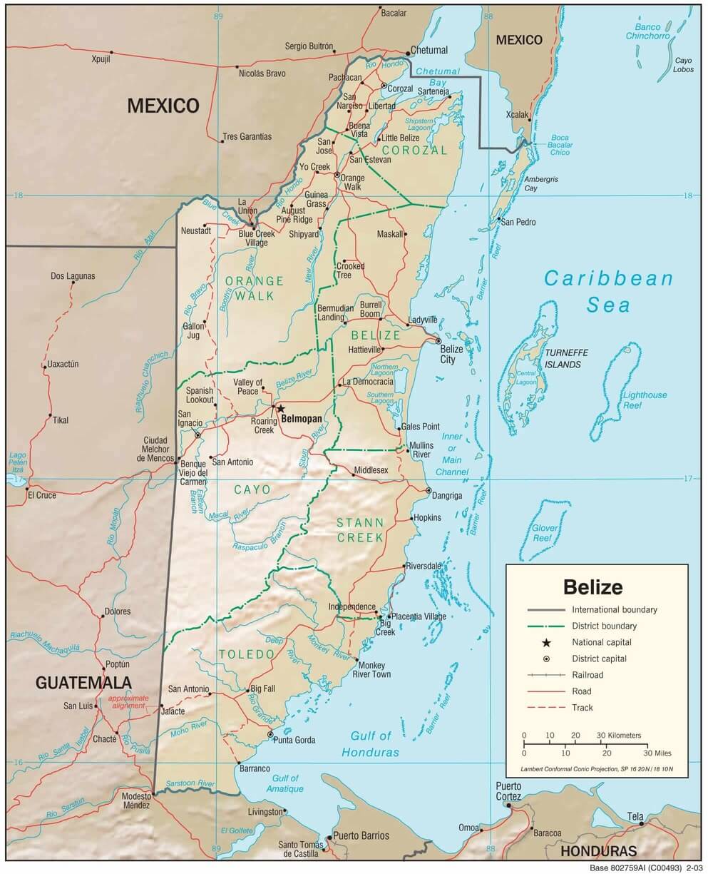
Physiographic map of Belize.
Significant Water Bodies of Belize
Major Rivers
Belize River
- Length: 290 km (180 mi)
- Origin: Northeastern Guatemala (as Río Mopán)
- Location: Flows northeast through San Ignacio, past Belmopan to Belize City
- Note: The Country's most important waterway, formed by the confluence of the Mopan and Macal rivers
Hondo River (Río Hondo)
- Length: 150 km (93 mi)
- Location: Forms the Mexico-Belize border, flows to Chetumal Bay
- Note: International boundary river, important for wildlife
Sarstoon River
- Length: 111 km (69 mi)
- Origin: Guatemala's Alta Verapaz Department
- Location: Forms the Belize-Guatemala border in the south
- Note: International boundary river, pristine ecosystems
Sibun River
- Length: 80+ km (50+ mi)
- Origin: Maya Mountains at 800 m elevation (as Caves Branch River)
- Location: Flows from the Cayo District to the Caribbean Sea near Belize City
- Note: Popular for cave tubing and adventure tourism
New River
- Location: Northern Belize, flows to the New River Lagoon
- Features: Provides access to the Lamanai archaeological site
- Note: Important for Maya heritage tourism
Monkey River
- Location: Southeastern Belize, Maya Mountains drainage
- Formation: Confluence of multiple streams 16 km from the mouth
- Note: Supports howler monkey populations, a pristine ecosystem
Mopan River
- Location: Western Belize, tributary forming the Belize River
- Origin: Guatemala's Petén region
- Note: Major tributary, archaeological significance
Macal River
- Location: Western Belize, flows north from the Maya Mountains
- Confluence: Joins the Mopan River near San Ignacio
- Note: Mountain-fed system supports diverse ecosystems
Manatee River
- Location: Central coastal region
- Features: Important manatee habitat, mangrove systems
- Note: Critical for the endangered West Indian manatee
Temash River
- Location: Southern Belize, near the Guatemala border
- Features: Pristine rainforest watershed
- Note: Supports Indigenous communities, intact ecosystems
Grande River
- Location: Far southern Belize
- Features: Intact rainforest drainage
- Note: Supports jaguar and tapir populations
Major Lakes and Lagoons
New River Lagoon
- Area: 13.5 km² (5.2 sq mi)
- Location: Northern Belize, connected to the New River
- Note: The country's largest lake, near Lamanai ruins
Northern Lagoon
- Location: South of Belize City, near the coast
- Type: Brackish coastal lagoon
- Note: Important bird habitat
Southern Lagoon
- Location: South of Belize City, near the coast
- Type: Brackish coastal lagoon
- Note: Part of the coastal wetland system
Marine Features
Caribbean Sea
- Coastline: 386 km (240 mi)
- Features: Barrier reef, cayes, atolls
- EEZ: 35,351 km² (13,649 sq mi)
- Territorial sea: 12 nautical miles (22 km)
Belize Barrier Reef
- Length: 300+ km (186+ mi)
- Type: The second-longest barrier reef system globally
- Status: UNESCO World Heritage Site
- Note: Part of the Mesoamerican Reef System
Turneffe Atoll
- Area: 531 km² (205 sq mi)
- Type: The Largest coral atoll in the Caribbean
- Location: Offshore, east of Belize City
- Features: Marine protected area, diverse ecosystems
Lighthouse Reef Atoll
- Features: Blue Hole (304 m diameter, 124 m deep)
- Location: Eastern offshore waters
- Status: UNESCO World Heritage Site
- Note: Famous for diving, a circular marine sinkhole
Glover's Reef Atoll
- Status: UNESCO World Heritage Site, marine reserve
- Location: Southern offshore waters
- Features: Pristine coral systems, endangered species habitat
- Note: Model for sustainable fisheries management
Chetumal Bay
- Location: Northern border with Mexico
- Connection: Hondo River discharge point
- Type: Shallow coastal bay, shared with Mexico
Cayes and Islands
Ambergris Caye
- Location: Northern coast, largest caye
- Features: Tourism center, barrier reef access
- Note: Major dive and snorkel destination
Caye Caulker
- Location: Northern coast, near Ambergris Caye
- Features: Tourism destination, "The Split"
- Note: Popular backpacker destination
Placencia Caye
- Location: Southern coast
- Features: Tourism development, reef access
- Note: Peninsula and caye system
St. George's Caye
- Location: Near Belize City
- Historical significance: Former colonial capital
- Note: Site of the 1798 Battle of St. George's Caye
Additional Water Bodies
Caves Branch River
- Location: Maya Mountains, upper Sibun River system
- Features: Cave systems, underground rivers
- Note: Popular for cave tubing adventures
Bladen Branch
- Location: Southern Maya Mountains, Monkey River tributary
- Features: Pristine rainforest drainage
- Note: Near the ancient Maya sites of Lubaantun and Nim Li Punit
Various Coastal Lagoons
- Location: Throughout coastal areas
- Type: Mangrove-fringed brackish systems
- Features: Nursery areas, bird habitat
- Note: Critical for marine ecosystem connectivity
Seasonal Wetlands
- Location: Coastal plains, various districts
- Type: Temporary flooding areas during the wet season
- Features: Migratory bird habitat, amphibian breeding
- Note: Important for regional biodiversity