The Geography of El Salvador: From Pacific Shores to Highland Peaks
El Salvador is Central America's smallest and most densely populated country. Despite its modest size, it features a highly diverse geographic landscape that has influenced its history, culture, and economy. This country shows how geographical factors can significantly impact every facet of a nation's life.

, CC BY 3.0, via Wikimedia Commons")


Between Volcanoes and Coasts: The Physical Geography of El Salvador
El Salvador, officially known as the Republic of El Salvador, stands as Central America's smallest and most densely populated nation. Despite its modest size of 21,041 square kilometers (8,124 square miles), roughly equivalent to the state of Massachusetts, El Salvador presents a remarkably diverse geographic landscape that has profoundly shaped its history, culture, and economic development. Nestled between Guatemala to the west and north, Honduras to the northeast, and the Pacific Ocean to the south, this nation exemplifies how geographic factors can influence every aspect of a country's existence.
Physical Geography
Location and Boundaries
El Salvador occupies a strategic position in Central America, lying between approximately 13°09' and 14°27' North latitude and 87°41' and 90°07' West longitude. The country stretches 270 kilometers (168 miles) from east to west at its widest point and varies between 142 kilometers (88 miles) from north to south. Its coastline extends 307 kilometers (191 miles) along the Pacific Ocean, providing the nation with significant maritime access and economic opportunities.
The country shares 342 kilometers (213 miles) of the border with Guatemala and 256 kilometers (159 miles) with Honduras. These borders, established through various treaties in the 19th and 20th centuries, have occasionally been sources of territorial disputes, most notably the Football War with Honduras in 1969, which was partly rooted in geographic and demographic pressures.
Topography and Elevation
El Salvador's topography is characterized by dramatic elevation changes that create distinct geographic zones. The country can be divided into four main topographic regions: the coastal lowlands, the southern mountain range, the central plateau, and the northern mountains.
The coastal lowlands, known as the Pacific coastal plain, extend inland for 10 to 15 kilometers (6 to 9 miles) and maintain elevations below 200 meters (656 feet). This region boasts fertile volcanic soils that support extensive agriculture, particularly in the cultivation of sugar cane and cotton.
Rising from the coastal plain, the southern mountain range forms the backbone of El Salvador's volcanic landscape. This range includes more than 20 volcanoes, with several reaching impressive heights. The highest point in the country is Cerro El Pital, located in the northern Chalatenango department near the Honduran border, which rises to 2,730 meters (8,957 feet) above sea level. However, the most prominent volcanic peaks include Santa Ana (Ilamatepec) at 2,381 meters (7,812 feet), San Vicente (Chichontepec) at 2,182 meters (7,159 feet), and San Salvador at 1,893 meters (6,211 feet).
The central plateau, situated between the volcanic range and the northern mountains, maintains elevations between 400 and 800 meters (1,312 to 2,625 feet). This region comprises some of El Salvador's most fertile agricultural lands and is home to the majority of the population, including the capital city of San Salvador.
The northern mountains represent an extension of the Sierra Madre range, featuring rugged terrain with elevations reaching up to 2,400 meters (7,874 feet). This region is characterized by steep slopes, deep valleys, and relatively sparse population density.
Volcanic Activity and Geology
El Salvador's position along the Pacific Ring of Fire makes it one of the most volcanically active countries in the world. The country sits atop the intersection of the Cocos Plate and Caribbean Plate, resulting in significant seismic activity and extensive volcanic formations. The volcanic chain that traverses the country from east to west has significantly shaped El Salvador's current topography and continues to influence its geographic development.
The volcanic soils, known locally as andisols, are exceptionally fertile and support intensive agriculture. However, volcanic activity also poses significant risks to the population. Major eruptions have occurred throughout history, with notable events including the 1917 eruption of San Salvador volcano and more recent activity at Santa Ana volcano in 2005.
Seismic activity remains a constant geographic reality, with major earthquakes occurring regularly. The devastating earthquakes of 1986, 2001, and others have resulted in significant casualties and economic damage, underscoring the ongoing influence of tectonic forces on the country's development.
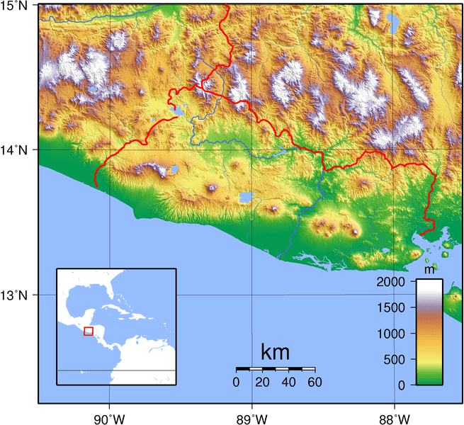
Topographic map of El Salvador.
Climate and Weather Patterns
El Salvador's location in the tropical zone, combined with its varied topography, creates a diverse climate system despite the country's small size. The nation experiences a tropical climate with distinct wet and dry seasons, but elevation significantly modifies temperature and precipitation patterns.
The lowland areas, including the coastal plain and regions below 600 meters (1,969 feet), experience a hot tropical climate with average temperatures ranging from 25°C to 29°C (77°F to 84°F) throughout the year. These regions receive annual precipitation ranging from 1,200 to 1,800 millimeters (47 to 71 inches), with the wet season lasting from May to October.
Highland areas above 1,000 meters (3,281 feet) experience a more temperate climate, with average temperatures ranging from 18°C to 22°C (64°F to 72°F). These regions often receive higher precipitation, sometimes exceeding 2,000 millimeters (79 inches) annually, due to orographic effects as moist air rises over the mountains.
The dry season, locally known as "verano" (summer), typically runs from November to April, while the wet season, referred to as "invierno" (winter), prevails from May to October. This seasonal pattern has a significant impact on agricultural practices, water resources, and daily life throughout the country.
Hydrography
River Systems
Despite its small size, El Salvador is home to numerous rivers and streams that flow into both the Pacific Ocean and the Caribbean Sea, although the vast majority drain into the Pacific. The country's river systems are relatively short due to the narrow width of the territory, but they play crucial roles in agriculture, hydroelectric power generation, and water supply.
The Lempa River stands as El Salvador's most significant waterway, spanning a total of 422 kilometers (262 miles), with 267 kilometers (166 miles) flowing through Salvadoran territory. Originating in Guatemala, the Lempa crosses into El Salvador in the northwest and flows southeastward before emptying into the Pacific Ocean. This river drains approximately 10,255 square kilometers (3,959 square miles), representing nearly half of El Salvador's total area.
Other important Pacific-draining rivers include the Paz River, which forms part of the border with Guatemala, the Jiboa River, and the Grande de San Miguel River. These waterways, while shorter than the Lempa, provide essential water resources for their respective regions.
A small portion of northern El Salvador drains toward the Caribbean Sea via the Motagua River system, which flows through Guatemala to reach the Caribbean coast.
Lakes and Water Bodies
El Salvador is home to several significant lakes, most of which are of volcanic origin. Lake Ilopango, located southeast of San Salvador, covers approximately 72 square kilometers (28 square miles) and reaches depths of up to 230 meters (755 feet). This lake, formed by a massive volcanic caldera, serves as both a recreational area and a source of geothermal energy.
Lake Coatepeque, situated in the crater of an extinct volcano, covers 24.8 square kilometers (9.6 square miles) and is renowned for its exceptional beauty and clear waters. At an elevation of 745 meters (2,444 feet), it maintains cooler temperatures than the surrounding lowland areas.
Güija Lake, shared with Guatemala, represents the largest natural lake entirely within Salvadoran territory, covering 44 square kilometers (17 square miles). This lake serves as an important ecological hub and provides vital water resources for the surrounding communities.
Several artificial reservoirs have been created for hydroelectric power generation, including the Cerrón Grande Reservoir on the Lempa River, which covers 135 square kilometers (52 square miles) when at full capacity.
Regional Geography
Pacific Coastal Region
The Pacific coastal region extends along El Salvador's entire southern border, encompassing the coastal plain and adjacent volcanic slopes. This region boasts a diverse array of ecosystems, ranging from mangrove swamps and estuaries to volcanic beaches with distinctive black sand. The coastline includes several bays and estuaries that provide natural harbors, most notably the Gulf of Fonseca in the east, which El Salvador shares with Honduras and Nicaragua.
Economically, this region supports fishing industries, salt production, and increasingly important tourism sectors. The port of Acajutla serves as El Salvador's primary Pacific port facility, handling the majority of the country's international trade.
Central Valley Region
The central valley region encompasses the area between the volcanic chain and the northern mountains, containing the most fertile agricultural lands and the highest population density. This region includes the metropolitan area of San Salvador, which is home to approximately one-third of the nation's population.
The volcanic soils of this region support intensive coffee cultivation on the volcanic slopes, while the valley floors are utilized for subsistence agriculture and urban development. This geographic concentration of population and economic activity reflects both the region's favorable climate and fertile soils.
Northern Highland Region
The northern highland region, characterized by the extension of the Sierra Madre range, represents El Salvador's most sparsely populated area. This region features rugged topography, cooler temperatures, and greater isolation from major transportation networks.
Despite lower population density, this region plays important roles in watershed protection, coffee cultivation at higher elevations, and subsistence agriculture. The geographic isolation has helped preserve traditional cultural practices and Indigenous influences more than in other regions.
Human Geography and Settlement Patterns
Population Distribution
El Salvador's population distribution reflects the strong influence of geographic factors, particularly elevation, soil fertility, and access to transportation networks. With a population density of approximately 310 people per square kilometer (803 people per square mile), El Salvador ranks among the most densely populated countries in the Americas.
The central plateau and volcanic slopes are home to the highest population concentrations, with the San Salvador metropolitan area alone housing over 2.4 million people, accounting for more than one-third of the national population. This concentration reflects the favorable climate, fertile soils, and economic opportunities available in this region.
Coastal areas support moderate population densities, particularly around port cities and fishing communities, while the northern highlands remain relatively sparsely populated due to difficult terrain and limited economic opportunities.
Urban Centers
El Salvador's urban geography reflects both its colonial heritage and modern economic development patterns. San Salvador, the capital and largest city, dominates the urban hierarchy, with a metropolitan population exceeding 2.4 million people. Located in the central valley at an elevation of 659 meters (2,162 feet), the city benefits from a favorable climate and a strategic location.
Other significant urban centers include Santa Ana in the west, with approximately 374,000 people; San Miguel in the east, with about 247,000 residents; and the port city of Soyapango, which forms part of the greater San Salvador metropolitan area.
These urban centers developed primarily due to geographic advantages such as fertile agricultural hinterlands, favorable climates, strategic locations along transportation routes, or access to natural resources.
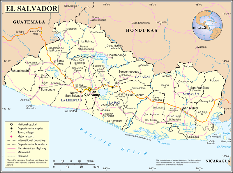
Map of El Salvador.
Economic Geography
Agricultural Regions
El Salvador's agricultural geography reflects the close relationship between physical geography and economic activity. The fertile volcanic soils support intensive agriculture, while variations in elevation and climate create distinct agricultural zones.
Coffee cultivation predominates on the volcanic slopes between 500 and 1,500 meters (1,640 to 4,921 feet) in elevation, capitalizing on cooler temperatures, adequate rainfall, and well-drained volcanic soils. This geographic concentration has made coffee the country's most important traditional export crop.
The coastal plains support sugar cane cultivation, benefiting from high temperatures, adequate moisture, and flat terrain that is well-suited for mechanized agriculture. Cotton production also occurs in this region, though it has declined significantly in recent decades.
The central valleys support a diverse range of agricultural activities, including basic grains (such as corn, beans, and rice), as well as a variety of vegetables and fruits. These areas benefit from fertile soils, adequate rainfall, and proximity to urban markets.
Industrial Geography
El Salvador's industrial development has been significantly influenced by geographic factors, particularly access to transportation networks, proximity to urban labor supplies, and availability of natural resources. The majority of industrial activity is concentrated in and around San Salvador, benefiting from the largest labor pool, the best transportation access, and proximity to government services.
The development of maquiladora industries has created new industrial centers, often strategically located to capitalize on transportation access to ports and airports for export-oriented production. These facilities primarily produce textiles and apparel for export to the United States.
Geothermal energy development in El Salvador leverages the country's volcanic geography, with several geothermal plants generating a significant portion of the country's electricity supply.
Transportation Geography
El Salvador's transportation network reflects the influence of topography, population distribution, and economic activity patterns. The Pan-American Highway serves as the primary east-west transportation corridor, connecting major urban centers and providing access to neighboring countries.
The mountainous topography creates challenges for transportation development, with many rural areas remaining poorly connected to national transportation networks. The concentration of roads and infrastructure in the central valley reflects both topographic constraints and economic priorities.
El Salvador maintains two international airports, with the primary facility located southeast of San Salvador, while port facilities at Acajutla and La Unión provide maritime access for global trade.
Environmental Geography
Natural Hazards
El Salvador's location and geographic characteristics expose the country to numerous natural hazards that significantly influence human activities and development patterns. Volcanic eruptions, earthquakes, landslides, flooding, and hurricanes all pose regular threats to the population and economy.
Seismic activity remains constant due to the country's position along active tectonic plate boundaries. Major earthquakes have repeatedly caused significant casualties and economic damage, influencing building practices, urban planning, and disaster preparedness efforts.
Volcanic activity poses ongoing risks, with several active volcanoes monitored continuously for signs of increased activity. While volcanic soils provide agricultural benefits, eruptions can cause immediate destruction and long-term environmental impacts.
The mountainous topography and intense rainfall during the wet season create conditions conducive to landslides, particularly in areas where deforestation has exacerbated slope instability. Flooding occurs regularly in low-lying areas and along major river systems.
Environmental Challenges
Rapid population growth and intensive land use have created significant environmental challenges throughout El Salvador. Deforestation has reduced forest cover to less than 14% of the national territory, contributing to soil erosion, watershed degradation, and loss of biodiversity.
Water pollution affects many of the country's rivers and lakes, resulting from inadequate sewage treatment, industrial discharge, and agricultural runoff. These problems are exacerbated by high population density and intensive land-use patterns.
Air pollution, particularly in urban areas, is primarily caused by vehicle emissions, industrial activities, and agricultural burning. The topographic setting of major cities can trap pollutants and worsen air quality problems.
Climate change poses emerging challenges, with potential impacts including altered precipitation patterns, increased temperature extremes, and more frequent or intense natural disasters.
Conclusion
The geography of El Salvador illustrates the profound impact that the physical environment has on human societies. Despite its small size, the country's diverse topography, volcanic origins, and tropical location create complex geographic patterns that continue to shape population distribution, economic activities, and environmental challenges.
The concentration of population and economic activity on the central plateau reflects the advantages provided by fertile volcanic soils, a favorable climate, and a strategic location. However, this same geographic setting exposes the population to significant natural hazards, creating ongoing challenges for development and disaster preparedness.
El Salvador's geographic characteristics, as a small, densely populated, and naturally hazard-prone nation, offer important insights into the relationships between physical geography and human development. The country's experience demonstrates both the opportunities and constraints that geographic factors create, while highlighting the importance of sustainable development practices in managing its limited territorial resources.
Understanding El Salvador's geography is crucial for addressing contemporary challenges, including environmental degradation, vulnerability to natural disasters, and promoting sustainable economic development. The country's geographic legacy continues to influence its prospects, making geographic knowledge crucial for effective planning and policy development.
As El Salvador moves forward into the 21st century, its geographic characteristics will continue to shape the opportunities and constraints that affect its development. Success in addressing current challenges and building a sustainable future will require careful consideration of the geographic factors that have long influenced life in this remarkable Central American nation.