Lake Managua: Nicaragua's Ecological Treasure
Lake Managua, also known as Lago Xolotlán, is a vital body of water for Nicaragua. The capital city of Managua is on its southwestern shore, making it an essential economic lifeline. The lake's abundant aquatic resources sustain the livelihoods of the people in the region.
, CC BY-SA 2.5 <https://creativecommons.org/licenses/by-sa/2.5>, via Wikimedia Commons")

 https://www.flickr.com/photos/adamcohn/9719464459")
Lake Managua
Nicaragua's Ecological Treasure
Nestled in the heart of Nicaragua lies Lake Managua, a body of water as storied as it is vital to the region. Also known as Lago Xolotlán, this expansive lake spans approximately 1,035 square kilometers (400 square miles), with the vibrant capital city of Managua gracing its southwestern shore. However, Lake Managua faces significant environmental challenges, primarily stemming from decades of pollution and neglect.
Geographical and Geological Significance
Lake Managua's dimensions are impressive; they are a testament to the sheer scale of nature's grandeur. Spanning approximately 58 kilometers (36 miles) in length and 25 kilometers (16 miles) in width, its sprawling waters dominate the landscape, carving a significant presence in Nicaragua's geographical expanse.
Amidst this expansive water body, the majestic silhouette of the Momotombo Volcano rises proudly from the northwestern shore, casting its imposing shadow across the lake's tranquil surface. Standing tall at an elevation of 1,280 meters (4,199 feet) above sea level, this iconic landmark commands attention, adding a dramatic and awe-inspiring backdrop to the lake's breathtaking scenic beauty.
Economic and Ecological Importance
Economically, Lake Managua is a vital lifeline for local communities, crucially sustaining livelihoods through its abundant aquatic resources. Its waters, brimming with a diverse array of fish and even alligators, support thriving fishing communities that rely on the lake's bounty for sustenance and economic prosperity. These fishing activities provide essential food sources and contribute to the region's economic vitality through trade and commerce.
Moreover, Lake Managua serves as a vital transportation artery, with shallow-draft vessels traversing its waters to facilitate the movement of goods and people along its shores. This transportation network plays a significant role in connecting remote communities and fostering economic exchange within the region, enhancing access to essential resources and opportunities.
Hydrological Dynamics
Lake Managua's hydrological dynamics shape the region's landscape, ecology, and environmental resilience. The lake is a vital watershed collecting and storing water from its surrounding catchment area, fed by a network of streams originating from the central highlands and the Diriamba Highlands. These streams, which flow into Lake Managua, not only replenish its water supply but also transport sediments, nutrients, and organic matter, enriching the lake's ecosystem and supporting its diverse aquatic life.
One of the notable features of Lake Managua's hydrology is its intermittent connection to Lake Nicaragua through the Tipitapa River. This natural conduit facilitates the exchange of water and nutrients between the two bodies, influencing their respective hydrological cycles and ecological dynamics. During heavy rainfall, the Tipitapa River is a vital outlet for excess water, helping regulate water levels and prevent flooding in both lakes.
However, despite its vital role as a conduit for water exchange, Lake Managua's hydrology is characterized by complexity and variability. Various factors, including evaporation, precipitation, and inflow from upstream sources, drive fluctuating water levels. Evaporation, in particular, significantly influences water levels, especially during prolonged dry weather when water loss from the lake's surface outpaces inflow from its tributaries. The absence of a stable outlet exacerbates the impact of pollutants on Lake Managua's water quality.
Environmental Challenges and Conservation Efforts
Despite its ecological importance, Lake Managua faces significant environmental challenges, primarily stemming from decades of pollution and neglect. Since 1927, the city sewers have discharged untreated wastewater into the lake, contributing to its contamination and degradation over time. This unchecked pollution has resulted in severely compromised water quality, threatening aquatic ecosystems' health and surrounding communities' well-being.
In response to these environmental threats, concerted conservation efforts have been initiated to mitigate the lake's degradation and restore its ecological health. These efforts include establishing wastewater treatment facilities, such as the modern treatment plant opened in Managua in 2009, to address the city's untreated sewage discharge. While these measures represent necessary steps toward environmental remediation, more comprehensive strategies are needed to address the root causes of pollution and ensure the long-term sustainability of Lake Managua's ecosystem.
Furthermore, community-based initiatives and environmental education programs are crucial in raising awareness about the importance of lake conservation and promoting sustainable practices among residents. By fostering a sense of stewardship and collective responsibility for the lake's well-being, these grassroots efforts aim to empower communities to actively participate in preserving and protecting this invaluable natural resource for future generations.
Cultural and Societal Implications
The cultural and societal implications of Lake Managua are deeply intertwined with the history, livelihoods, and resilience of the communities that call its shores home. For generations, local inhabitants have relied on the lake's resources for sustenance, livelihoods, and cultural practices, forging a profound connection to its waters and surrounding landscapes. Despite the environmental challenges posed by pollution and fluctuating water levels, many residents continue to reside along its shores, drawing upon its bounty for fishing, agriculture, and other traditional activities.
However, the lake's tumultuous history, marked by devastating floods and environmental degradation, underscores the urgent need for sustainable urban planning and disaster preparedness measures. The catastrophic floods of 1933 and 1998 left a lasting impact on the communities living in the lake's vicinity, causing widespread destruction of homes, infrastructure, and livelihoods. These events served as wake-up calls, highlighting the vulnerability of settlements along the lake's shores to natural disasters and the pressing need for effective risk management strategies.
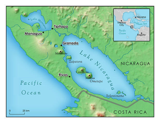
Map depicting Lake Managua and Lake Nicaragua.