The Geography of Guyana: Where the Amazon Meets the Atlantic
Guyana is one of South America's most geographically distinctive nations, occupying a unique position where the Caribbean cultural sphere meets the Amazon Basin. The nation's remarkable geographic diversity ranges from coastal plains below sea level to ancient mountain plateaus.
 https://www.flickr.com/photos/hoppy1951/8528902472")
 https://www.flickr.com/photos/sorenriise/395861020/")


The Geographic Mosaic of Guyana: Land of Many Waters
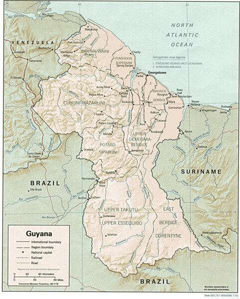
Guyana, whose name derives from the Amerindian word "Guiana," meaning "land of many waters," represents one of South America's most geographically distinctive nations. This country, spanning approximately 214,969 square kilometers (83,000 square miles), serves as the only English-speaking nation in South America and occupies a unique position where the Caribbean cultural sphere meets the Amazon Basin.
Strategically located on the northern coast of South America between Venezuela, Brazil, and Suriname, Guyana possesses an extensive Atlantic coastline that has profoundly shaped its settlement patterns and economic development. The nation's remarkable geographic diversity, ranging from coastal plains below sea level to ancient mountain plateaus exceeding 2,700 meters (8,858 feet), creates distinct physiographic regions that support extraordinary biodiversity and a wide range of human activities.
Physical Geography and Physiographic Regions
Guyana's topography can be divided into four distinct physiographic regions, each characterized by unique geological formations, elevation patterns, and ecological systems. This geographic organization reflects the country's complex geological history and its position at the intersection of several major South American landforms.
The Low Coastal Plain extends approximately 25-75 kilometers (16-47 miles) inland from the Atlantic Ocean, encompassing roughly 5% of the national territory. This region lies largely below sea level, with elevations ranging from sea level to only 1-2 meters (3-7 feet) above mean high tide. The coastal plain consists primarily of marine and estuarine sediments deposited over millennia, creating fertile alluvial soils that support intensive agriculture and contain approximately 90% of Guyana's population.
The Hilly Sand and Clay Belt forms a transitional zone between the coastal plain and the interior highlands, covering approximately 20% of the country. This region is characterized by rolling hills and undulating terrain with elevations ranging from 30 to 150 meters (98 to 492 feet). The area consists primarily of Tertiary sediments and weathered crystalline rocks, creating a landscape of lateritic soils and seasonal wetlands.
The Interior Highlands represent the most extensive physiographic region, encompassing roughly 70% of Guyana's territory. This vast area includes portions of the ancient Guiana Shield, one of Earth's oldest geological formations, dating back over 2 billion years. The region features a complex topography of peneplains, isolated mountains, and deeply incised river valleys, with elevations generally ranging from 150 to 1,000 meters (492 to 3,281 feet) above sea level.
The fourth region comprises the Mountain Ranges of the far south and west, including the Pakaraima Mountains, also known as the Pacaraima Mountains, along the borders with Brazil and Venezuela. These ancient formations include Guyana's highest peak, Mount Roraima, which rises to 2,772 meters (9,094 feet) and represents one of the World's most distinctive tepuis (table mountains). Located at the tripoint where Venezuela, Guyana, and Brazil meet, Mount Roraima holds special significance as a shared natural landmark among the three nations. These isolated massifs support unique ecosystems and endemic species found nowhere else on Earth.
The Kanuku Mountains, situated in southwestern Guyana within the Rupununi region, comprise another significant mountain system that spans approximately 6,000 square kilometers (2,317 square miles). The name means "forest" in the Wapishana language, a reference to the rich diversity of wildlife that can be found in the area. These mountains feature rock formations that rise to 1,300 meters (4,265 feet) in height, waterfalls, and numerous caves, and are divided into the Eastern and Western Kanuku Mountains by the Rupununi River. The Kanukus have the highest recorded bat diversity in the World with 89 species and represent one of the most ecologically diverse locations in the country.
Guyana shaded relief map.
River Systems and Hydrology
Guyana's epithet as the "land of many waters" reflects its extraordinarily rich hydrological resources, with numerous major river systems draining different portions of the country toward the Atlantic Ocean. The nation's river systems not only provide crucial transportation corridors through otherwise inaccessible terrain but also support diverse aquatic ecosystems and significant hydroelectric potential.
The Essequibo River, Guyana's longest and most significant waterway, flows approximately 1,010 kilometers (628 miles) from its headwaters in the Acarai Mountains to its mouth on the Atlantic coast. This mighty river drains nearly 70% of the country's territory and serves as a crucial transportation artery connecting the interior highlands with the coastal region. The Essequibo's extensive tributary system includes the Rupununi, Mazaruni, and Cuyuni rivers, each draining distinct physiographic regions.
The Demerara River, though shorter at approximately 346 kilometers (215 miles), holds particular significance as it flows past Georgetown, the nation's capital and largest city. This river system drains the central coastal region and provides important transportation links between the capital and interior settlements.
The Berbice River system drains the eastern portion of the country, flowing approximately 595 kilometers (370 miles) from the interior highlands to the Atlantic coast. Like other major Guyanese rivers, the Berbice serves multiple functions, including transportation, fishing, and small-scale mining activities.
The Corentyne River forms a significant portion of Guyana's eastern border with Suriname, flowing northward for approximately 724 kilometers (450 miles) before reaching the Atlantic Ocean. This river system represents a significant international boundary and supports substantial cross-border trade and cultural exchange.
Among the most spectacular features of Guyana's river systems is Kaieteur Falls, located on the Potaro River in the country's interior highlands. This magnificent waterfall plunges 226 meters (741 feet) in a single drop, making it one of the World's most powerful waterfalls by volume. The falls are situated within Kaieteur National Park, which encompasses 627 square kilometers (242 square miles) of pristine rainforest and represents one of Guyana's most important protected areas. The park's unique ecosystem supports several endemic species, including the golden frog (Brachycephalus ephippium) and various rare orchid species. The surrounding forests provide habitat for jaguars, harpy eagles (Harpia harpyja), and cock-of-the-rock (Rupicola rupicola).
Coastal Geography and Maritime Environment
Guyana's Atlantic coastline extends approximately 459 kilometers (285 miles) and exhibits characteristics typical of tropical South American shores, including extensive mangrove systems, mudflats, and estuarine environments. The coastal zone represents one of the most dynamic and economically important regions of the country, supporting the majority of the population and most industrial activities.
The coastline is characterized by extensive mud banks and mangrove forests that provide crucial ecological services, including coastal protection, nursery habitats for marine species, and carbon sequestration. The dominant mangrove species include Rhizophora mangle (red mangrove), Avicennia germinans (black mangrove), and Laguncularia racemosa (white mangrove), which form dense forests extending up to 20 kilometers (12 miles) inland in some areas.
The coastal waters are influenced by sediment discharge from major rivers, particularly the Amazon River system to the southeast, creating turbid conditions and extensive shallow areas. These conditions support important fisheries, particularly for marine shrimp and various fish species that form the basis of significant export industries.
Sea level rise and coastal erosion represent ongoing challenges for Guyana's coastal communities. Much of the coastal plain lies below high-tide levels and relies on an extensive system of sea walls, drainage canals, and pumping stations for protection from flooding. This infrastructure, originally developed during the Dutch colonial era, requires ongoing maintenance and upgrades to address shifting sea levels and changing storm patterns.
Climate and Weather Patterns
Guyana experiences a tropical climate with relatively uniform temperatures throughout the year but distinct seasonal precipitation patterns that significantly influence both natural ecosystems and human activities. The country's position just north of the equator and its extensive coastline create specific climatic conditions that vary somewhat between coastal and interior regions.
Coastal areas experience average temperatures ranging from 24 °C to 32°C (75°F to 90°F) throughout the year, with minimal seasonal variation due to the moderating influence of the Atlantic Ocean. Relative humidity remains consistently high, typically ranging from 70% to 85%, which contributes to the perception of heat and affects comfort levels for residents and visitors.
The interior regions exhibit slightly greater temperature variation, with highland areas experiencing cooler conditions due to the effects of elevation. Areas above 1,000 meters (3,281 feet) may experience nighttime temperatures dropping to 15-18°C (59-64°F), providing relief from the persistent heat of the lowlands.
Precipitation patterns follow a distinct seasonal cycle, characterized by two wet seasons and two dry seasons. The major damp season extends from approximately May through August, while a shorter wet season occurs from December through February. The intervening periods represent dry seasons, with the longer dry season occurring from September through November and the shorter one in March and April.
Annual precipitation varies significantly across the country, ranging from approximately 1,500 millimeters (59 inches) in some coastal areas to over 3,000 millimeters (118 inches) in the interior highlands. The mountainous regions of the south and west receive the highest precipitation totals, supporting extensive rainforest ecosystems.
Ecosystems and Biodiversity
Guyana's diverse physiography and climatic conditions have created an extraordinary array of ecosystems that support some of the highest levels of biodiversity in South America. The country's position within the Guiana Shield and its connection to the larger Amazon Basin contribute to its exceptional species richness and high levels of endemism.
The coastal region supports extensive mangrove ecosystems that serve as critical nursery habitats for numerous marine species, providing important ecological services that contribute to coastal protection. These mangrove systems support populations of the endangered Trichechus manatus (West Indian manatee) and numerous bird species, including the Eudocimus ruber (scarlet ibis), which serves as one of Guyana's national symbols.
The interior lowland forests represent some of the most pristine tropical rainforests in South America, characterized by a diverse array of tree species, including Chlorocardium rodiei (greenheart), Aspidosperma excelsum (paddlewood), and various palm species, such as Mauritia flexuosa (moriche palm). These forests support populations of large mammals, including Panthera onca (the jaguar), Tapirus terrestris (the South American tapir), and Priodontes maximus (the giant armadillo).
The highland forests and tepui ecosystems represent centers of endemism with numerous plant and animal species found nowhere else on Earth. Mount Roraima and other tepuis support unique communities of carnivorous plants, including Heliamphora species (marsh pitcher plants) and various endemic Drosera species (sundews). These isolated mountaintop ecosystems have evolved in isolation for millions of years, creating natural laboratories of evolution.
The savanna regions of the Rupununi provide habitat for species more typical of the Brazilian Cerrado, including the Chrysocyon brachyurus (maned wolf) and various species of rheas (Rhea americana). These grassland ecosystems support different assemblages of species adapted to seasonal flooding and fire regimes.
Human Geography and Settlement Patterns
Guyana's human geography reflects the profound influence of its physical geography, with population distribution heavily concentrated in the coastal plain, despite this region representing only 5% of the national territory. This settlement pattern, established during the colonial period, continues to shape the country's demographic and economic characteristics.
Georgetown, the capital and largest city, is situated on the Demerara River, near the Atlantic coast, and has a population of approximately 235,000 within its greater metropolitan area. The city's location on the coastal plain, which is below sea level, necessitates extensive drainage infrastructure and flood protection systems that significantly influence urban planning and development patterns.
The East Bank and West Bank Demerara regions, along with the coastal areas of Berbice and Essequibo, contain most of Guyana's agricultural lands and the majority of its population. These areas support intensive rice and sugar cultivation, taking advantage of the fertile alluvial soils and flat terrain that facilitate mechanized agriculture and irrigation systems.
The interior regions remain sparsely populated, with small settlements typically situated along major rivers, which provide the primary means of transportation and communication. Indigenous communities, representing approximately 10% of the national population, are primarily located in these interior areas and maintain traditional relationships with the forest and savanna ecosystems.
Mining communities have developed in various interior locations, particularly in areas with significant deposits of gold, diamonds, and bauxite. These settlements often exhibit boom-and-bust characteristics related to resource extraction cycles and commodity prices in international markets.
Natural Resources and Economic Geography
Guyana's diverse geology and extensive forest cover provide the foundation for a resource-based economy that depends heavily on mining, forestry, and agriculture. The country's position within the ancient Guiana Shield has created significant mineral wealth, while its tropical climate and fertile soils support important agricultural sectors.
The bauxite industry represents one of Guyana's most important economic sectors, with extensive deposits located in the Berbice River region. These deposits, formed over millions of years through the weathering of aluminum-rich rocks, support large-scale mining operations that provide a significant portion of the country's export earnings and government revenues.
Gold mining, both large-scale and artisanal, occurs throughout the interior regions, particularly in areas where ancient rocks of the Guiana Shield are exposed. The country's gold resources have attracted mining activities since the colonial period and continue to provide important economic opportunities, though often with significant environmental impacts.
Forest resources represent another crucial component of Guyana's natural wealth, with approximately 85% of the country covered by intact tropical forests. These forests support a sustainable timber industry focused on valuable hardwood species such as Chlorocardium rodiei (greenheart) and Ocotea puberula (silverballi). Additionally, the forests provide important ecosystem services, including carbon storage, which has become increasingly valuable in international carbon markets.
Agricultural activities are concentrated primarily in the coastal plain, where fertile alluvial soils and flat terrain support the intensive cultivation of rice and sugarcane. The rice industry, in particular, has become increasingly important as a source of export earnings and food security, capitalizing on the abundant water resources and suitable growing conditions.
Environmental Challenges and Conservation
Guyana faces numerous environmental challenges related to its geographic characteristics and development pressures. Climate change poses particular risks to the low-lying coastal areas, where sea level rise and increased storm intensity threaten both human settlements and critical infrastructure.
Coastal erosion and flooding represent ongoing challenges for communities and economic activities located in the coastal plain. The country's extensive system of sea walls and drainage infrastructure requires ongoing maintenance and upgrades to address changing environmental conditions and increasing development pressures.
Deforestation and forest degradation, although still limited compared to other tropical countries, are emerging concerns as mining, logging, and agricultural activities expand into previously undisturbed areas. The challenge lies in balancing economic development needs with the conservation of the country's extraordinary biodiversity and forest resources.
Mining activities, particularly small-scale gold mining, have created localized environmental impacts, including mercury pollution, habitat destruction, and sedimentation of waterways. These activities often occur in remote areas with limited regulatory oversight, making ecological protection particularly challenging.
Despite these challenges, Guyana has made significant commitments to environmental conservation, including the establishment of extensive protected areas and participation in international conservation initiatives. The country's Low Carbon Development Strategy represents an innovative approach to balancing economic development with forest conservation, utilizing international payments for ecosystem services to support sustainable development.
Conclusion
The geography of Guyana presents a remarkable combination of ancient geological formations, diverse ecosystems, and unique climatic conditions, creating one of South America's most distinctive nations. From the below-sea-level coastal plains, where most of the population resides, to the ancient tepuis that harbor endemic species found nowhere else on Earth, Guyana's geographic diversity presents both opportunities and challenges for sustainable development.
The country's extensive river systems, pristine forests, and mineral resources offer significant potential for economic development, while its coastal location and low-lying terrain create vulnerabilities to climate change and sea-level rise. Understanding these geographic characteristics is essential for addressing contemporary challenges, ranging from sustainable resource management to climate change adaptation.
As Guyana continues to develop its economy while maintaining its commitment to environmental conservation, its success will largely depend on how effectively it can leverage its geographic advantages while addressing the constraints imposed by its physical environment. The country's role as a guardian of some of the World's last intact tropical forests, combined with its rich cultural diversity and strategic location, positions it as an important player in regional and global environmental and economic systems.
The "land of many waters" faces a future where its geographic heritage will continue to shape its development trajectory, requiring careful balance between economic opportunity and environmental stewardship in one of the World's most biodiverse and geographically complex nations.