Bahía Portete - Kaurrele National Natural Park: A Coastal Eden at the Edge of Colombia
Bahía Portete - Kaurrele National Natural Park lies at the northern tip of Colombia on the La Guajira Peninsula. It is South America's northernmost National Park, situated between Cabo de la Vela and Punta Gallinas, and offers an unspoiled coastal wonderland.


 https://www.flickr.com/photos/alveart/46463810745/in/photostream/")


Bahía Portete - Kaurrele National Natural Park
A Coastal Eden at the Edge of Colombia
Located on the La Guajira Peninsula, at the northernmost tip of Colombia, the Bahía Portete - Kaurrele National Natural Park boasts a stunning coastline. It is positioned between Cabo de la Vela and Punta Gallinas and claims the title of the northernmost National Park on the South American continent. In this sanctuary, the Caribbean Sea meets the arid embrace of the La Guajira Desert.
Geography and Conservation
Established in 2014 within the municipality of Uribia, La Guajira, this protected haven spans 14,080 hectares (34,792 acres), a mosaic of essential ecosystems safeguarded for their ecological significance. Sedimentary beds and seagrass meadows, coral formations, mangroves, sun-kissed beaches, and rugged coastlines harmoniously coexist within its boundaries. The park is a testament to Colombia's commitment to preserving its natural heritage for future generations.
Climate and Coastal Charms
The climate of Bahía Portete - Kaurrele National Natural Park reflects the surrounding La Guajira Desert — hot, arid, and influenced by coastal winds. Average temperatures range between 28 to 30 °C (82 to 86 °F), creating an environment where the sun's unyielding rays intensify the vibrant hues of the landscape. The coastal area, touched by humidity-laden winds, offers a unique blend of arid charm and maritime allure.
Marine Wonderland
The marine bay area unveils an underwater wonderland with an average depth of 9 meters (30 feet) and depths ranging from 3 to 20 meters (10 to 65 feet). Coral formations, seagrass meadows of Thalassia testudinum and Syringodium, and a thriving marine fauna ecosystem paint the waters with a kaleidoscope of life. Lobsters, shrimp, clams, oysters, grouper, sea bass, snapper, mullet, mackerel, and sardines habitat the sea, while turtles, armadillos, and an array of reptiles and amphibians add to the ecological richness of this coastal gem.
Flora and Fauna Symphony
The landscape, dominated by the Guajira-Barranquilla xeric scrub ecoregion, boasts hardy inhabitants adapting to the arid plains. Cacti, exemplified by Opuntia wentiana, stand resilient, while mangrove trees, including Avicennia germinans, grace the coastal edges. The seagrass meadows contribute to the park's biodiversity, creating a haven for marine life.
Indigenous Heritage and Conservation Allies
Approximately 500 indigenous Wayuu people call this sparsely populated region home. Their communities, including Wayuu, Kamushiwoü, Alijunao, Yariwanischi, Puerto Portete, Ian, Youlepa, Kayuuswaarraaloü, and Punta Cosos Espacios, played a pivotal role in the planning and establishment of the protected area. Their commitment to preserving their ancestral lands ensures a harmonious coexistence between nature and indigenous communities. Mining and industrial fishing are strictly prohibited, underscoring the collaborative efforts to safeguard this coastal Eden.
In the embrace of Bahía Portete - Kaurrele National Natural Park, the spirit of conservation, cultural heritage, and natural splendor converge, inviting all who venture here to witness the fragile beauty of Colombia's northern frontier. With its rich biodiversity and indigenous resilience, this coastal sanctuary stands as a beacon of hope for preserving our planet's delicate ecosystems.
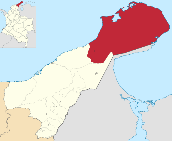
Map depicting the location of Uribia, Colombia.