
Volcán Isluga National Park: An Aymara Sacred Landscape in the High Altiplano
Volcán Isluga National Park, in the Tarapacá altiplano, protects about 175,000 hectares of high puna around a sacred Aymara volcano, one of the world's highest geyser fields, and an 18th-century church that remains the ceremonial heart of Aymara life.
Volcán Isluga National Park: An Aymara Sacred Landscape in the High Altiplano
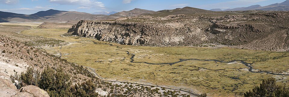
Volcán Isluga National Park lies in the Andes of northern Chile's Tarapacá Region, in the communes of Colchane, Huara, and Camiña of Tamarugal Province, just south of the Lauca Biosphere Reserve and close to the Bolivian border. It covers 174,744 hectares (about 431,800 acres) at an average elevation of about 4,000 m (13,100 ft), and its landscape of volcanoes, lagoons, and bunchgrass steppe is the Central Andean dry puna described in our Puna article. It is reached from Iquique via Route 15-CH, the international road from Huara through Colchane to Oruro, Bolivia, a drive of more than 200 km (125 mi).
A Park Cut Down to Size
Decree 4, promulgated on January 3, 1967, created the Volcán Isluga National Tourism Park, covering about 401,135 hectares (about 991,000 acres) of state land around the volcano. In 1985, its boundaries were redrawn, and part of the land was released, leaving the present 174,744 hectares. The Chilean forest service, CONAF, manages the park under a published management plan.
Isluga Volcano
The park is named for Isluga, a dormant stratovolcano about 5,550 m (18,200 ft) high, though sources cite several different heights. It stands 7 km (4.3 mi) west of the Bolivian border at the western end of a line of volcanoes that runs east to Cabaray and Tata Sabaya in Bolivia. Its elongated, snow-covered summit holds a well-preserved crater about 400 m (1,300 ft) wide, and faint fumaroles with sulfur deposits are visible on the crater rim and the southern flank. Isluga erupted repeatedly in the 19th century, in 1863, 1868, 1869, 1877, 1878, and 1885, with a smaller eruption in 1913, and lava flows in earlier eruptions damaged neighboring villages. The main modern hazard is ashfall, which could contaminate aquifers and destroy farmland in a landscape where both are scarce.
The name Isluga appears in neither Aymara nor Quechua, and its origin is unclear. The Aymara call the mountain Laram Qhawani, among other names, and the village of Enquelga at its foot considers it a sacred peak responsible for health, wealth, and rain.
A Living Aymara Landscape
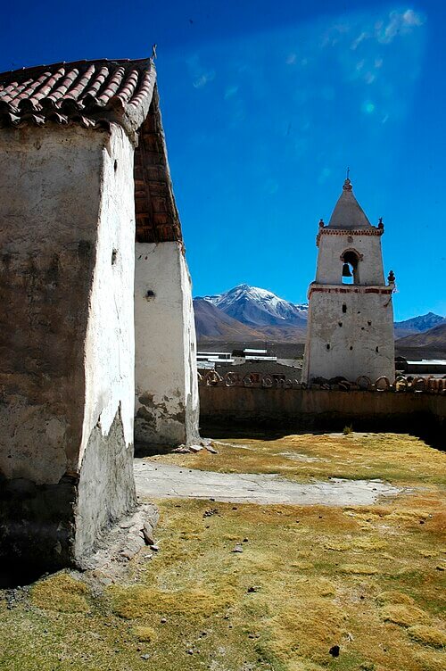
The park is home to Aymara communities and is also a protected landscape. Its ceremonial center is the village and church of Isluga, about 9 km (5.6 mi) from Colchane, where an adobe church with a separate bell tower, built in the 18th century, stands inside a walled atrium. The church was declared a Historic Monument in 1975 and sits empty most of the year except during ceremonies, when Aymara communities gather; only a single caretaker, the fabriquero, lives there permanently. The park also protects the Isluga pucará, a pre-Hispanic fortress reached by a trail of about 3 km (1.9 mi), the cemeteries of Usamalla and Alsuri, and a sanctuary on the volcano's summit where rituals are still held. Communities such as Enquelga, Chapicollo, and Caraguano herd llamas and alpacas on the wet meadows known as bofedales, weave textiles, and grow quinoa, and the Aymara calendar still includes festivals such as the Fiesta de Tomás on December 21.
The Puchuldiza Geysers
The park's most unusual feature after the volcano is the Puchuldiza geothermal field, at about 4,200 to 4,300 m (13,800 to 14,100 ft), one of the highest in the world. Its geysers, fumaroles, mud pools, and hot springs, more than a hundred separate features in all, release water at temperatures of 40 to 84 °C (104 to 183 °F) along the Puchuldiza River, in an area of about 1 sq km (0.4 sq mi), with a smaller field at Tuja 6 km (3.7 mi) to the northwest. The geysers are best seen at dawn, when the cold air makes their plumes visible, and Puchuldiza has also been studied as a possible source of geothermal power. Another high-altitude geyser field, El Tatio, is described in our Atacama Desert article.
Puna Plants and Animals
Vegetation ranges from shrubs, cacti, and queñoa trees (Polylepis rugulosa and Polylepis tarapacana) in the lower precordillera zone to cushion plants and bunchgrasses on the high plateau. On the grasslands live the suri (Rhea pennata tarapacensis), a rhea of the northern Andes, the puna tinamou (Tinamotis pentlandii), and the vicuña (Vicugna vicugna), and the lagoons attract the Andean flamingo (Phoenicoparrus andinus) and waterbirds such as the puna ibis (Plegadis ridgwayi), the Andean goose (Chloephaga melanoptera), and the Andean avocet (Recurvirostra andina). To the south, Salar del Huasco National Park protects a high-altitude wetland where all three South American flamingo species nest.
Colchane and the Border
The park's gateway, Colchane, sits at about 3,650 m (12,000 ft) on the Bolivian border, a mostly Aymara commune with roughly 1,600 residents. In early 2021, more than a thousand migrants, mostly Venezuelans, crossed the altiplano on foot in a single day, overwhelming the town and starting a crisis that has since reshaped life in the area. Researchers who have studied it find that the militarization of the border did not stop irregular crossings and strained relations between Aymara communities and migrants, in a region where Aymara families have crossed the frontier for generations. The park itself lies at the heart of this contested landscape.
Visiting the Park
The high altitude, cold nights, and distances call for preparation, and a four-wheel-drive vehicle is recommended beyond Huara. Visitors usually base themselves in Colchane, and CONAF, the Aymara communities, and local guides all offer access to the volcano trail, the Puchuldiza geysers, the Isluga church, and the Aravilla lagoon.
Conclusion
Isluga is a park defined less by wilderness than by the long relationship between a mountain and the people who live beneath it: a volcano that is also a deity, a church that is also a ceremonial center, and a frontier that Aymara families crossed long before it became a border. The park's future will depend on how Chile protects its landscape while respecting the communities whose homeland it is.