The Geography of Honduras: Land of Mountains and Two Seas
Honduras has a diverse and complex landscape shaped by its topography, which borders both the Caribbean Sea and the Pacific Ocean. The country serves as a vital bridge between North and South America, boasting a diverse range of ecosystems, climate zones, and geological features.


, https://www.flickr.com/photos/waterdotorg/19747498145")

From Caribbean Shores to Pacific Coast: The Diverse Landscapes of Honduras
Honduras, often referred to as the "heart of Central America," boasts one of the most geographically diverse and topographically complex landscapes in the region. This nation, spanning approximately 112,492 square kilometers (43,433 square miles), serves as a crucial bridge between North and South America, offering a remarkable array of ecosystems, climatic zones, and geological formations that have shaped both its natural heritage and human development patterns.
Strategically positioned between Guatemala, El Salvador, and Nicaragua, Honduras holds the unique distinction of having coastlines on both the Caribbean Sea and the Pacific Ocean. The nation's dramatic topographic relief, ranging from sea level to peaks exceeding 2,800 meters (9,186 feet), creates a vertical zonation of climates and ecosystems that makes it a critical component of the Mesoamerican Biological Corridor connecting North and South American fauna and flora.
Physical Geography and Topography
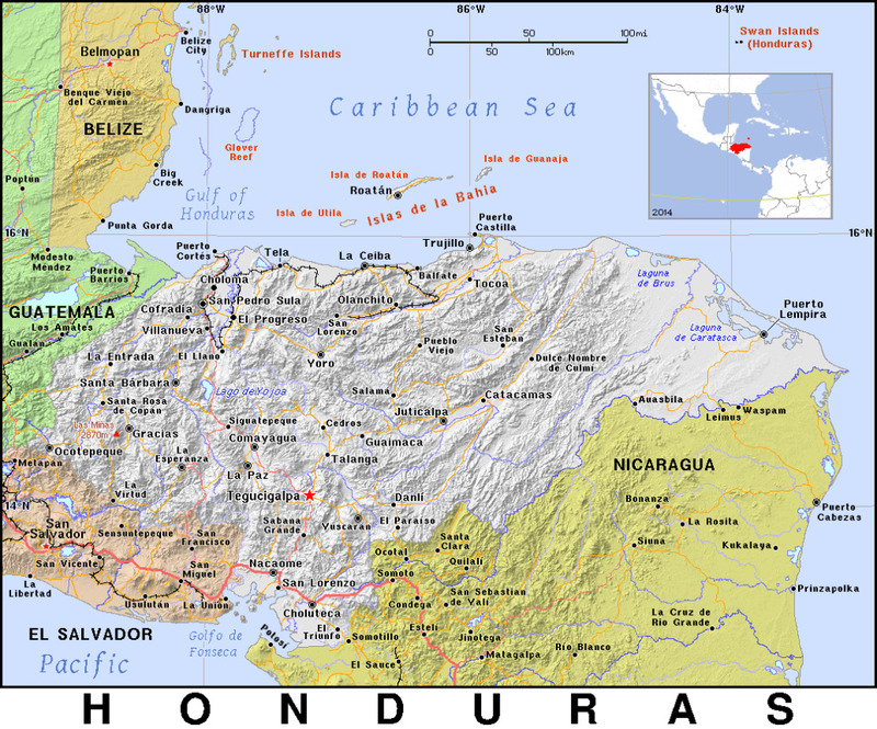
The defining characteristic of Honduras is its predominantly mountainous terrain, with approximately 80% of the country consisting of mountains and hills. The Cordillera Central dominates the nation's topography. This massive mountain range forms the backbone of the country and represents the southern extension of the Sierra Madre mountain system. This range includes Honduras's highest peak, Cerro Las Minas, which rises to 2,870 meters (9,416 feet) above sea level in the Celaque National Park.
The country's mountainous character creates a complex pattern of valleys, plateaus, and intermontane basins. The Sula Valley in the northwest and the Comayagua Valley in the central region represent the most significant lowland areas, serving as crucial agricultural zones and population centers. These valleys, carved by millennia of river erosion, provide fertile alluvial soils that contrast sharply with the thin, rocky soils typical of the mountainous regions.
The geological foundation of Honduras reflects its position along the complex junction of the North American, Caribbean, and Cocos tectonic plates. This tectonic complexity has created a landscape characterized by volcanic activity, seismic instability, and a diverse array of mineral deposits. The country's geology comprises Paleozoic metamorphic rocks, Mesozoic sedimentary formations, and Cenozoic volcanic deposits, which contribute to the varied topography and soil types found throughout the nation.
Coastal Geography and Maritime Boundaries
Honduras holds the unique distinction of having coastlines on both the Caribbean Sea and the Pacific Ocean, making it one of only three Central American nations to possess this geographic advantage. The Caribbean coast extends approximately 644 kilometers (400 miles) from the Guatemalan border to the mouth of the Río Coco on the Nicaraguan frontier. This northern coastline boasts a diverse range of coastal environments, including mangrove swamps, lagoons, sandy beaches, and rocky headlands.
The Pacific coastline, though much shorter at approximately 124 kilometers (77 miles), provides access to the Gulf of Fonseca, which Honduras shares with El Salvador and Nicaragua. This Pacific frontage, while limited, includes important port facilities and represents a crucial component of the country's maritime geography.
The Bay Islands (Islas de la Bahía), located 50-60 kilometers (31-37 miles) off the Caribbean coast, constitute one of Honduras's most distinctive geographic features. This archipelago includes three main islands: Roatán, Utila, and Guanaja, along with numerous smaller cays and islets. These islands, formed by ancient coral reef systems and volcanic activity, are surrounded by the Mesoamerican Reef System, the second-largest coral reef system in the World.
Honduras physical map.
River Systems and Hydrology
Honduras's river systems reflect the country's mountainous topography and dual coastal orientation. The continental divide runs roughly through the center of the country, separating rivers that flow toward the Caribbean from those that drain toward the Pacific. The Caribbean drainage basin encompasses approximately 85% of the national territory, while the Pacific basin accounts for the remaining 15%.
The most significant river system is the Río Ulúa, which originates in the central mountains and flows northward through the Sula Valley before emptying into the Caribbean Sea. This river, along with its major tributary the Río Chamelecón, drains approximately 21,000 square kilometers (8,100 square miles) and serves as a crucial transportation and agricultural corridor.
The Río Coco (also known as Río Segovia) forms much of the border with Nicaragua and represents the longest river in Central America, measuring approximately 680 kilometers (425 miles). Other significant Caribbean-draining rivers include the Río Aguán, Río Patuca, and Río Motagua, each of which carves distinct valleys through the mountainous terrain.
Pacific drainage is characterized by shorter, steeper rivers, reflecting the proximity of the continental divide to the Pacific coast. The Río Choluteca and Río Nacaome are the primary Pacific-draining systems, flowing southward through narrow valleys before reaching the Gulf of Fonseca.
Climate and Weather Patterns
Honduras experiences a tropical climate that is significantly modified by elevation, resulting in distinct climatic zones throughout the country. The lowland areas, particularly along the Caribbean coast, experience a hot, humid tropical climate with temperatures averaging 26-28°C (79-82°F) throughout the year. These coastal regions receive substantial precipitation, with annual rainfall totals often exceeding 2,500 millimeters (98 inches) per year.
The mountainous interior exhibits a more temperate climate, with temperatures decreasing approximately 6°C per 1,000 meters of elevation (3.3°F per 1,000 feet). Highland areas above 1,500 meters (4,921 feet) experience what locals call "eternal spring" conditions, with moderate temperatures averaging 18-24°C (64-75°F) and distinct wet and dry seasons.
The country's climate is significantly influenced by the trade wind system, which brings moisture-laden air from the Caribbean Sea. The windward (Caribbean-facing) slopes of the mountains receive considerably more precipitation than the leeward (Pacific-facing) slopes, creating distinct rainfall patterns across the country. The wet season typically lasts from May to November, while the dry season spans from December to April.
Ecosystems and Biodiversity
Honduras's varied topography and climate have created an extraordinary diversity of ecosystems, making it one of the most biodiverse countries in Central America. The nation encompasses portions of two major biogeographic regions: the Nearctic and Neotropical realms, contributing to its exceptional species richness.
The Caribbean lowlands support extensive tropical rainforests dominated by species such as Cecropia peltata (the trumpet tree), Terminalia amazonia (yellowwood), and various palm species, including Roystonea regia (the royal palm). These forests provide habitat for numerous mammalian species, including the endangered Tapirus bairdii (Baird's tapir), Panthera onca (jaguar), and Trichechus manatus (West Indian manatee).
The cloud forests of the central highlands represent one of Honduras's most unique ecosystems. These high-elevation forests, characterized by persistent cloud cover and high humidity, support endemic species such as the Pharomachrus mocinno (resplendent quetzal) and numerous orchid species, including Brassavola nodosa and Oncidium sphacelatum.
Pine forests dominate much of the mountainous interior, particularly at elevations between 600 and 2,400 meters (1,969 and 7,874 feet). These forests are primarily composed of Pinus oocarpa (ocote pine) and Pinus tecunumanii, adapted to the cooler temperatures and seasonal precipitation patterns of the highlands.
The coastal mangrove ecosystems, particularly along the Caribbean shore, support critical nursery habitats for marine species and provide important ecological services, including coastal protection and carbon sequestration. Dominant mangrove species include Rhizophora mangle (red mangrove), Avicennia germinans (black mangrove), and Laguncularia racemosa (white mangrove).
Human Geography and Settlement Patterns
Honduras's challenging topography has significantly influenced human settlement patterns throughout its history. The majority of the population is concentrated in the intermontane valleys and coastal plains, where agricultural potential is greatest and transportation infrastructure is most developed.
The capital city, Tegucigalpa, located in the central highlands at approximately 990 meters (3,248 feet) above sea level, exemplifies the influence of topography on urban development. The city's location in a narrow valley surrounded by steep mountains has constrained its growth and complicated infrastructure development.
San Pedro Sula, the country's industrial center, is situated in the fertile Sula Valley and benefits from its strategic location near the Caribbean coast and proximity to major transportation routes. This geographic advantage has made it Honduras's economic hub and most populous urban area.
The sparsely populated eastern regions, characterized by dense forests and challenging terrain, remain among the least developed areas of the country. These regions, including much of the Mosquitia, represent some of Central America's last remaining wilderness areas but face increasing pressure from agricultural expansion and resource extraction.
Natural Resources and Economic Geography
Honduras's varied geology has endowed the country with significant mineral resources, including silver, gold, lead, zinc, and iron ore. The western mountains, particularly around the town of El Mochito, contain important zinc and lead deposits, while gold mining operations are scattered throughout the mountainous regions.
The country's forest resources represent another crucial component of its natural wealth. Pine forests in the interior mountains support a significant timber industry, while the diverse tropical forests provide numerous non-timber forest products. However, deforestation rates remain an important concern, with forest cover declining from approximately 75% in the 1960s to less than 45% today.
Agricultural geography reflects the country's topographic diversity. The fertile lowlands and valley bottoms support export crops such as bananas, coffee, and African palm, while the highland areas are suited for temperate crops, including coffee, vegetables, and basic grains. The geographic distribution of agricultural activities has created distinct regional economies tied to specific crops and environmental conditions.
Environmental Challenges and Natural Hazards
Honduras's geographic location and topographic complexity expose it to numerous natural hazards that significantly impact human activities and economic development. The country lies within the Central American seismic zone, making it susceptible to earthquakes and volcanic activity. While Honduras has no active volcanoes, it experiences regular seismic activity due to its position along active fault systems.
Hurricane activity represents one of the most significant natural hazards facing Honduras. The country's extensive Caribbean coastline and low-lying areas make it particularly vulnerable to tropical storms and hurricanes during the Atlantic hurricane season. Hurricane Mitch in 1998 and Hurricanes Eta and Iota in 2020 demonstrated the devastating potential of these weather systems, causing widespread flooding, landslides, and infrastructure damage.
The mountainous terrain and intense seasonal precipitation patterns create conditions conducive to landslides and flash flooding. Deforestation and inappropriate land use practices have exacerbated these risks, particularly in areas where steep slopes have been cleared for agriculture or settlement.
Climate change is beginning to alter traditional weather patterns, with potential implications for agricultural productivity, water resources, and the stability of ecosystems. Rising sea levels pose a threat to coastal communities and infrastructure, while changing precipitation patterns may alter the geographic distribution of crops and natural vegetation.
Conclusion
The geography of Honduras represents a complex tapestry of physical features, climatic conditions, and ecological systems that have profoundly shaped the nation's development trajectory. From the cloud-draped peaks of the central mountains to the coral reefs of the Bay Islands, from the tropical rainforests of the Mosquitia to the pine forests of the interior highlands, Honduras encompasses a remarkable diversity of landscapes within its modest territorial boundaries.
Understanding this geographic complexity is crucial for addressing the country's contemporary challenges, ranging from sustainable development and environmental conservation to natural disaster preparedness and climate change adaptation. The nation's geographic endowment presents both opportunities and constraints that will continue to shape its future development patterns and environmental stewardship efforts.
As Honduras moves forward into the 21st century, its success will largely depend on how effectively it balances the exploitation of its natural resources with the preservation of its extraordinary geographic heritage. The country's position as a biological corridor between North and South America, its role as a watershed for both Caribbean and Pacific drainage systems, and its function as a cultural bridge in Central America all underscore the global significance of its unique geographic character.