The Geography of Ecuador: Land of Four Worlds and the Equatorial Divide
Ecuador, one of South America's most diverse and compact countries, boasts a variety of landscapes, climates, and ecosystems, including the Andes' peaks, the Amazon's rich biodiversity, dry coastal plains, and the Galápagos Islands. This diversity promotes a rich biodiversity and complex ecosystems.
 https://www.flickr.com/photos/bentavener/7165491786")
 https://www.flickr.com/photos/franzleonardo/5934877768")

 via Wikimedia Commons")


Equatorial Convergence: Ecuador's Role as a Geographic and Biological Crossroads
Ecuador stands as one of the most geographically diverse and compact nations on the South American continent, encompassing an extraordinary range of landscapes, climates, and ecosystems within its 283,561 square kilometers (109,484 square miles). Named for its position astride the equatorial line, Ecuador presents a unique geographical tapestry that encompasses the snow-capped peaks of the Andes Mountains, the lush biodiversity of the Amazon rainforest, the arid coastal plains of the Pacific Ocean, and the volcanic islands of the Galápagos archipelago. This remarkable geographical diversity, compressed into a territory smaller than Nevada, has created conditions supporting some of the highest biodiversity levels on Earth and one of the world's most complex patterns of human settlement and cultural development.
Bordered by Colombia to the north, Peru to the east and south, and the Pacific Ocean to the west, Ecuador's strategic location has profoundly influenced its natural and human geography throughout history. The country's position at the equator, combined with dramatic elevation changes exceeding 6,000 meters (19,685 feet) from sea level to the summit of Chimborazo, creates climatic conditions ranging from tropical rainforests to glaciated peaks, often within distances of less than 100 kilometers (62 miles). This geographical complexity has given rise to distinct regional identities, economic specializations, and environmental challenges that continue to shape Ecuador's development in the 21st century.
Physical Geography and Topography
Ecuador's topographical complexity can be understood through four distinct geographical regions that reflect the country's position at the intersection of major geological and climatic systems. These regions – La Costa (the coast), La Sierra (the highlands), El Oriente (the east/Amazon), and the Galápagos Islands – each present unique topographical characteristics that have profoundly influenced settlement patterns, economic activities, and cultural development.
La Sierra, the Andean highlands region, dominates Ecuador's interior and represents one of the most dramatic topographical features in South America. The Ecuadorian Andes divide into two parallel cordilleras – the Cordillera Occidental (Western Cordillera) and the Cordillera Oriental (Eastern Cordillera) – creating a central highland valley system known as the Avenue of the Volcanoes. This remarkable geological formation extends approximately 325 kilometers (202 miles) from north to south and encompasses over 70 volcanic peaks, many of which exceed 4,000 meters (13,123 feet) in elevation.
Chimborazo, Ecuador's highest peak at 6,263 meters (20,548 feet) above sea level, represents the highest point in Ecuador and, due to the Earth's equatorial bulge, the point on Earth's surface farthest from the planet's center. Other significant peaks include Cotopaxi at 5,897 meters (19,347 feet), one of the world's highest active volcanoes, and Cayambe at 5,790 meters (18,996 feet), the only point on the equator where snow persists year-round. These towering peaks create dramatic topographical contrasts with the inter-Andean valleys that lie between 2,000 and 3,000 meters (6,562 and 9,843 feet) in elevation, supporting the majority of Ecuador's highland population.
La Costa encompasses the Pacific coastal plain, extending inland from the ocean for distances varying from 20 to 180 kilometers (12 to 112 miles). This region presents a topography of gentle rolling hills, river valleys, and alluvial plains that rarely exceed 300 meters (984 feet) in elevation. The coastal region encompasses the Guayas River basin, Ecuador's most significant lowland river system, which drains approximately 32,000 square kilometers (12,355 square miles) of territory, creating extensive wetlands and agricultural plains near the port city of Guayaquil.
El Oriente, Ecuador's Amazonian region, encompasses approximately 45% of the country's territory yet supports less than 5% of its population. This region features a topography of gradually descending terrain, ranging from the eastern slopes of the Andes to the lowland Amazon basin, with elevations decreasing from approximately 1,200 meters (3,937 feet) along the Andean foothills to less than 200 meters (656 feet) at the eastern border with Peru. The region is characterized by numerous river systems flowing eastward toward the Amazon River, creating a landscape of river terraces, floodplains, and interfluves covered by dense tropical rainforest.
The Galápagos Islands, located approximately 1,000 kilometers (621 miles) west of the mainland, represent a unique volcanic archipelago consisting of 13 major islands, six smaller islands, and over 100 islets and rocks. These volcanic islands, formed by hotspot volcanism over the Nazca Plate, range in elevation from sea level to 1,707 meters (5,600 feet) at the summit of Wolf Volcano on Isabela Island. The islands present a varied topography, ranging from recent lava flows and volcanic cones to eroded highlands and coastal plains, which support unique ecosystems found nowhere else on Earth.
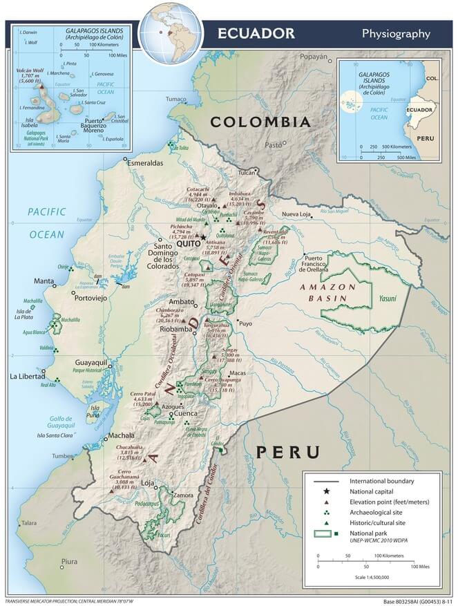
Physiographic map of Ecuador.
Climate and Weather Patterns
Ecuador's climatic diversity reflects the complex interaction of latitude, elevation, ocean currents, and topography that creates numerous climatic zones within a relatively compact territory. Despite its equatorial location, Ecuador's climate patterns are largely influenced by elevation effects, resulting in conditions that range from tropical rainforests at sea level to polar-like conditions on the highest mountain peaks.
The coastal region experiences a tropical climate significantly influenced by ocean currents and seasonal wind patterns. The cold Humboldt Current, flowing northward along the South American coast, moderates temperatures and reduces precipitation along much of the coast, creating relatively dry conditions compared to other equatorial regions. Average temperatures along the coast range from 23°C to 26°C (73°F to 79°F) throughout the year, with minimal seasonal variation due to the equatorial location.
The coastal climate exhibits two distinct seasons: the wet season, from December to May, when the warm Panama Current brings increased precipitation and higher temperatures, and the dry season, from June to November, when the cooler Humboldt Current prevails, resulting in lower temperatures and reduced precipitation. Annual rainfall varies significantly across the coastal region, from less than 250 millimeters (10 inches) in the southwestern desert areas to over 3,000 millimeters (118 inches) in the northwestern coastal forests near the Colombian border.
The Sierra region exhibits complex climatic patterns, primarily determined by elevation and topographical position in relation to prevailing wind patterns. The inter-Andean valleys, situated between 2,000 and 3,000 meters (6,562 and 9,843 feet) in elevation, experience a subtropical highland climate with average temperatures ranging from 13°C to 18°C (55°F to 64°F) and relatively consistent conditions throughout the year. These valleys experience two wet seasons corresponding to the equinoxes (March-May and October-December) and two drier periods during the solstices.
At higher elevations, temperatures decrease approximately 6°C per 1,000 meters of elevation gain (3.5°F per 1,000 feet), creating alpine conditions above 3,500 meters (11,483 feet) and glacial conditions on the highest peaks. The páramo ecosystem, occurring between 3,500 and 4,500 meters (11,483 and 14,764 feet), experiences cool temperatures averaging 3°C to 9°C (37°F to 48°F) with frequent fog, high humidity, and significant temperature variations between day and night.
El Oriente experiences a tropical rainforest climate characterized by high temperatures, high humidity, and abundant precipitation throughout the year. Average temperatures range from 24°C to 27°C (75°F to 81°F) with minimal seasonal variation, while annual rainfall typically exceeds 2,500 millimeters (98 inches) and can reach over 4,000 millimeters (157 inches) in some areas. The region experiences a slightly drier period from December to February, though precipitation remains significant even during these months.
The Galápagos Islands present a unique oceanic climate influenced by the convergence of warm and cool ocean currents. The islands experience two distinct seasons: a warm, wet season from December to June, when the Panama Current brings higher temperatures and increased precipitation, and a cool, dry season from July to November, when the Humboldt Current prevails. Temperatures range from 18°C to 28°C (64°F to 82°F) depending on elevation and season, while precipitation varies dramatically from less than 200 millimeters (8 inches) in coastal areas to over 1,500 millimeters (59 inches) in highland zones.
Hydrography and Water Resources
Ecuador's hydrographic network reflects the country's position astride the continental divide, with river systems flowing toward both the Pacific Ocean and the Atlantic Ocean via the Amazon River system. The Andes Mountains create the primary watershed divide, with approximately 90% of Ecuador's territory draining eastward toward the Amazon basin and 10% draining westward toward the Pacific Ocean.
The Pacific watershed encompasses numerous river systems flowing from the western slopes of the Andes across the coastal plain to the Pacific Ocean. The Guayas River represents the most significant Pacific drainage system, formed by the confluence of the Daule and Babahoyo rivers and flowing approximately 56 kilometers (35 miles) from their junction to the Gulf of Guayaquil. The Guayas basin drains approximately 32,000 square kilometers (12,355 square miles) and supports Ecuador's most important agricultural and industrial region, including the port city of Guayaquil.
Other significant Pacific rivers include the Esmeraldas River in the north, which drains approximately 21,000 square kilometers (8,108 square miles) and provides water resources for both agricultural and urban development in the northern coastal region. The Chone, Portoviejo, and Jama rivers serve smaller coastal basins but play important roles in regional water supply and agricultural irrigation systems.
The Amazon watershed encompasses the vast majority of Ecuador's territory and includes portions of several major Amazon tributaries. The Napo River, Ecuador's largest Amazon tributary, flows approximately 1,075 kilometers (668 miles) from its headwaters in the Andes to its confluence with the Amazon River in Peru. The Napo basin drains approximately 100,000 square kilometers (38,610 square miles) of Ecuadorian territory and serves as a critical transportation corridor for communities in El Oriente.
The Pastaza River system drains the central Amazonian region of Ecuador, flowing eastward from the inter-Andean valley through dramatic gorges in the eastern cordillera before entering the broad Amazon lowlands. The Pastaza and its tributaries provide water resources for both Indigenous communities and emerging oil extraction activities in the central Amazon region.
The Santiago River forms part of the border between Ecuador and Peru in the southern Amazon region, draining approximately 30,000 square kilometers (11,583 square miles) of Ecuadorian territory. This river system supports important biodiversity and Indigenous communities while also representing a significant source of potential conflict over water rights and resource extraction.
Ecuador's water resources are facing increasing pressure from population growth, agricultural expansion, mining activities, and the impacts of climate change. The country's glaciers, which provide critical water supplies during dry seasons, have experienced significant retreat due to rising temperatures, with several peaks losing their permanent snow cover entirely during the past century. Water quality issues affect both urban and rural areas, with pollution from agricultural chemicals, mining activities, and inadequate sewage treatment posing threats to both human health and aquatic ecosystems.
Coastal Geography and Marine Environment
Ecuador's Pacific coastline stretches approximately 2,237 kilometers (1,390 miles), encompassing both the mainland coast and the Galápagos Islands, and featuring diverse marine environments that reflect the influence of ocean currents, coastal topography, and human activities. The mainland coast presents a diverse array of geographical features, including sandy beaches, rocky headlands, mangrove estuaries, and river deltas, which create distinct marine habitats that support a wide range of diverse biological communities.
The northern coast, extending from the Colombian border to approximately Manta, features extensive beaches, mangrove forests, and river estuaries that create productive marine environments. The Cayapas-Mataje Ecological Reserve encompasses some of the most pristine mangrove ecosystems on the Pacific coast of South America, supporting populations of endemic species and serving as nursery areas for commercially important fish and shellfish species.
The central coast, centered on the Guayas River delta and the Gulf of Guayaquil, represents Ecuador's most economically important coastal region. The Guayas estuary supports extensive wetland systems that cater to both natural ecosystems and human activities, including shrimp farming, fishing, and port operations. The port of Guayaquil, located approximately 60 kilometers (37 miles) inland from the ocean, serves as Ecuador's primary commercial port and handles the majority of the country's international trade.
The southern coast features drier conditions and different geological formations, including areas of desert and semi-arid vegetation that extend to the ocean. The Santa Elena Peninsula represents the westernmost point of mainland Ecuador and features unique dry coastal ecosystems that support endemic plant and animal species adapted to arid conditions.
The convergence of warm and cool ocean currents has a significant impact on Ecuador's marine environment. The cold Humboldt Current, flowing northward along the coast, brings nutrient-rich waters that support high levels of marine productivity and important fishing industries. During El Niño events, warm tropical waters from the north dominate the coastal marine environment, dramatically altering fish populations, weather patterns, and coastal ecosystems.
The Galápagos Marine Reserve, encompassing 138,000 square kilometers (53,282 square miles) of ocean around the islands, represents one of the world's most important marine protected areas. The convergence of several ocean currents around the islands creates unique marine conditions that support extraordinary biodiversity, including endemic species found nowhere else on Earth. The marine environment includes coral reefs, rocky reefs, sandy beaches, and deep-water habitats that support populations of hammerhead sharks, whale sharks, marine iguanas, sea lions, and numerous endemic fish species.
Geological Foundation
Ecuador's geological complexity reflects its position at the intersection of several tectonic plates and geological processes that have operated over millions of years to create the country's diverse landscapes and mineral resources. The country primarily sits on the South American Plate, with the oceanic Nazca Plate subducting beneath it along the Pacific coast, creating the geological conditions responsible for the Andes Mountains and the active volcanism that characterizes much of Ecuador's geography.
The Andes Mountains in Ecuador form part of the larger Andean mountain system, consisting primarily of volcanic rocks and sedimentary formations that have been uplifted and deformed through tectonic processes. The Western Cordillera consists primarily of oceanic rocks and volcanic formations that were accreted to the South American continent through the process of subduction. In contrast, the Eastern Cordillera contains older metamorphic rocks and sedimentary formations that represent the ancient margin of the South American continent.
Active volcanism continues to shape Ecuador's landscape, with over 70 volcanic centers identified within the country's borders. The most recent major eruptions include Reventador, which has been continuously active since 2002, and Tungurahua, which experienced significant activity from 1999 to 2016. These volcanic systems not only create dramatic landscapes but also contribute to soil fertility through the deposition of volcanic ash and the weathering of volcanic rocks into nutrient-rich soils.
The coastal region consists primarily of sedimentary rocks deposited in marine and terrestrial environments over the past 100 million years. These formations include sandstones, shales, and limestones that contain important petroleum deposits, particularly in the Gulf of Guayaquil and offshore areas. The coastal geology also includes recent alluvial deposits created by rivers flowing from the Andes, forming the fertile plains that support much of Ecuador's agricultural production.
The Amazon region features a complex geology of sedimentary rocks deposited in ancient marine and fluvial environments, overlain by more recent alluvial deposits created by the Amazon River system and its tributaries. This region contains significant petroleum reserves that have become increasingly important to Ecuador's economy since the 1970s; however, oil extraction activities pose significant environmental challenges to pristine rainforest ecosystems.
The Galápagos Islands represent a unique geological environment created by hotspot volcanism over the Nazca Plate. The islands range in age from less than 1 million years for the youngest western islands to over 4 million years for the oldest eastern islands. This age gradient gives rise to distinct stages of ecological succession and speciation, which contribute to the islands' extraordinary biodiversity and scientific significance.
Seismic activity represents a significant geological hazard throughout Ecuador due to the active tectonic setting. Major earthquakes have caused substantial damage and loss of life, including the 2016 earthquake near the coast that killed over 650 people and caused billions of dollars in damage. Ongoing seismic monitoring and building codes aim to reduce earthquake risks, though the geological setting ensures that seismic hazards will remain a permanent challenge for development planning.
Soils and Land Use
Ecuador's soil geography reflects the complex interaction of geology, climate, topography, and biological processes operating across diverse environmental conditions. Volcanic soils, known as andisols, cover significant portions of the Sierra region and represent some of the most fertile soils in South America, supporting intensive agricultural production and dense rural populations.
Andisols in the inter-Andean valleys are characterized by high organic matter content, excellent water retention capacity, and high fertility levels, which support a diverse range of agricultural activities, including flower cultivation, vegetable production, and grain crops. These soils, derived from volcanic ash and weathered volcanic rocks, can support population densities exceeding 200 people per square kilometer (518 people per square mile) in some rural areas, representing some of the highest rural population densities in Latin America.
The coastal region features diverse soil types reflecting varied geological conditions and climate patterns. Alluvial soils deposited by rivers create fertile conditions for agriculture, particularly in the Guayas River basin, where rice, corn, and other crops support important agricultural industries. However, coastal soils also include problematic vertisols with high clay content that expand and contract with changes in moisture, creating challenges for construction and agriculture.
Amazon soils present unique characteristics that reflect the tropical rainforest environment and the underlying sedimentary geology. Oxisols and ultisols dominate the region, characterized by high acidity, low nutrient content, and aluminum toxicity that limits agricultural potential without significant soil amendments. These soils, while supporting extraordinary biodiversity in natural forest ecosystems, pose significant challenges for sustainable agriculture and development.
Highland soils above 3,500 meters (11,483 feet) in elevation consist primarily of histosols and inceptisols, characterized by high organic matter content and slow decomposition rates due to cool temperatures. These páramo soils play a critical role in regulating water and storing carbon, although they are fragile and easily damaged by overgrazing or inappropriate land-use practices.
Land use patterns in Ecuador reflect both geographical constraints and economic opportunities. Approximately 20% of the country's territory is designated as protected areas, including national parks, ecological reserves, and wildlife refuges that preserve representative samples of different ecosystems. Agricultural activities occupy approximately 29% of the land area, utilizing various crops and livestock systems that are adapted to specific geographical conditions.
Coffee and cacao cultivation utilize the fertile slopes of the Andes and coastal mountains, taking advantage of specific elevation and climate conditions that produce high-quality products for export markets. Banana production, concentrated in the coastal lowlands, has made Ecuador the world's largest banana exporter. Meanwhile, flower cultivation in the highland valleys has created a significant export industry, capitalizing on year-round growing conditions and proximity to international air transportation.
Biodiversity and Ecosystems
Ecuador ranks among the world's most biodiverse countries, supporting an estimated 15,000-20,000 plant species, over 1,600 bird species, 400 mammal species, 400 reptile species, and 600 amphibian species within its compact territory. This extraordinary biodiversity reflects Ecuador's position at the intersection of multiple biogeographical regions, its extreme elevation gradients, and its diverse range of climatic conditions and habitats.
The Amazon region alone supports over half of Ecuador's biodiversity, featuring tropical rainforest ecosystems that include some of the most species-rich habitats on the planet. Yasuní National Park, situated in the central Amazon region, is home to over 2,200 tree species, 204 mammal species, 610 bird species, and an estimated 100,000 insect species per hectare in certain locations. This level of diversity surpasses that found in many entire countries, underscoring the global significance of Ecuador's Amazon ecosystems.
The Andes Mountains support distinct ecosystems at various elevations, resulting in a vertical zonation of habitats that significantly contributes to the region's overall biodiversity. Cloud forests on the eastern slopes of the Andes exhibit high levels of endemism, particularly among plants, birds, and amphibians adapted to the persistent fog and high humidity conditions. The páramo ecosystem above the treeline supports unique plant and animal communities adapted to cool temperatures, intense solar radiation, and extreme daily temperature fluctuations.
The coastal region encompasses a diverse range of ecosystems, from dry forests and scrublands in the south to humid tropical forests in the north. The Chocó biogeographical region, extending into northwestern Ecuador from Colombia, is one of the world's biodiversity hotspots, characterized by exceptionally high levels of endemic species. Coastal mangrove ecosystems provide critical habitats for numerous species and serve as nurseries for marine organisms.
The Galápagos Islands support relatively low overall diversity but exceptionally high levels of endemism, with approximately 40% of plant species and 80% of terrestrial vertebrate species found nowhere else on Earth. The islands' isolation and varied habitats have created natural laboratories for evolution and speciation, making them invaluable for scientific research and conservation.
Ecuador's biodiversity faces significant threats from habitat loss, fragmentation, pollution, and climate change. Deforestation rates in the Amazon region have accelerated due to agricultural expansion, road construction, and oil exploration, while coastal ecosystems face pressure from urban development, aquaculture, and pollution. Climate change poses additional threats, particularly to high-elevation ecosystems and glacially-fed water systems that support both natural ecosystems and human communities.
Human Geography and Settlement Patterns
Ecuador's population of approximately 17.8 million people is distributed unevenly across the country's diverse geographical regions, reflecting the fundamental influence of topography, climate, and resource availability on human settlement patterns. The Sierra region, which encompasses only 22% of the country's territory, supports approximately 45% of the national population, demonstrating the attractive force of fertile volcanic soils, moderate climate conditions, and historical settlement patterns established during the pre-Columbian and colonial periods.
The inter-Andean valleys, particularly around Quito, Cuenca, Ambato, and Riobamba, support the highest rural population densities in Ecuador and some of the highest in Latin America. These valleys, situated at elevations between 2,000 and 3,000 meters (6,562 and 9,843 feet), feature fertile volcanic soils, favorable climate conditions, and abundant water resources that have supported intensive agriculture and dense settlement for over a thousand years.
Quito, Ecuador's capital city, exemplifies the influence of geography on urban development. Located at an elevation of 2,850 meters (9,350 feet) in a narrow inter-Andean valley surrounded by volcanic peaks, Quito has developed as a linear city extending north-south along the valley floor. The city's elevation provides moderate temperatures year-round, while the surrounding volcanoes create dramatic scenery and influence local climate patterns through orographic effects.
La Costa supports approximately 49% of Ecuador's population, despite encompassing only 25% of the country's territory, with the population concentrated primarily in the Guayas River basin and around the port city of Guayaquil. Guayaquil, with over 2.7 million inhabitants in the metropolitan area, is Ecuador's largest city and primary commercial center, leveraging its proximity to the river and ocean, fertile agricultural hinterlands, and connections to international markets.
El Oriente, despite covering 45% of Ecuador's territory, supports less than 5% of the national population, reflecting the challenges posed by dense forest cover, limited transportation infrastructure, difficult terrain, and humid tropical climate conditions. The population in the Amazon region is concentrated primarily along rivers and in areas developed for oil extraction, with Indigenous communities maintaining traditional settlement patterns that are adapted to forest environments.
The Galápagos Islands support a resident population of approximately 33,000 people concentrated in a few settlements on four of the main islands. Population growth in the islands is strictly controlled due to environmental concerns, although tourism and research activities bring thousands of temporary visitors each year.
Ecuador's ethnic composition reflects both its Indigenous heritage and centuries of cultural mixing, with approximately 72% of the population identifying as mestizo (having mixed Indigenous and European ancestry), 7% as Montubio (coastal mixed heritage), 7% as Afro-Ecuadorian, 4% as Indigenous, and 6% as white. Indigenous groups, including Quechua-speaking peoples in the highlands and diverse Amazonian peoples such as the Shuar and Achuar, maintain distinct cultural identities and often inhabit specific geographical regions that reflect historical territories and adaptation to local environmental conditions.
Natural Resources and Economic Geography
Ecuador's natural resource base reflects its diverse geographical environments and geological history, with petroleum, agricultural products, fisheries, and minerals forming the foundation of the national economy. Oil resources, discovered in the Amazon region in the 1960s, transformed Ecuador's economy and continue to provide approximately 30-40% of the government's revenues and over 50% of its export earnings.
The petroleum industry primarily operates in the Amazon region, where sedimentary rocks contain significant oil reserves estimated to be over 8 billion barrels. Major oil fields include Sacha, Shushufindi, and Auca; meanwhile, newer developments in Yasuní National Park have sparked significant environmental controversies. Oil production necessitates extensive infrastructure, including pipelines that cross the Andes to coastal refineries and export terminals, highlighting the challenges of resource extraction in geographically diverse and environmentally sensitive regions.
Agricultural resources in Ecuador capitalize on the country's diverse climatic conditions and fertile soils to produce both subsistence and export crops. Banana production, concentrated in the coastal lowlands, has made Ecuador the world's largest banana exporter, with annual exports exceeding 6 million tons valued at over $3 billion. The industry benefits from year-round growing conditions, fertile alluvial soils, and well-developed transportation and port infrastructure.
Coffee and cacao cultivation utilize specific elevation and climate zones to produce high-quality products for specialty markets. Ecuadorian cacao, particularly the fine flavor Nacional variety, is considered among the world's finest and commands premium prices in international chocolate markets. Coffee production primarily focuses on Arabica varieties grown on Andean slopes between 1,200 and 2,000 meters (3,937 and 6,562 feet) in elevation.
The flower industry has emerged as a significant export sector, leveraging its equatorial location, high elevation, and consistent climate conditions to produce cut flowers year-round. Ecuador ranks as the fourth-largest flower exporter globally, with production concentrated in the highland valleys around Quito, where cool temperatures, intense sunlight, and proximity to international airports create ideal conditions.
Fishing resources along the Pacific coast support important industries targeting tuna, shrimp, and other marine species. The convergence of ocean currents creates productive marine conditions, although El Niño events periodically disrupt fish populations, necessitating the development of adaptive management strategies to mitigate these disruptions.
Mining activities primarily focus on gold, silver, and copper deposits in the Andes Mountains, although the industry remains relatively underdeveloped compared to other Andean countries. Large-scale mining projects face significant environmental and social challenges due to the sensitive ecosystems and water resources of highland regions.
Tourism has grown rapidly as an economic sector, generating over $2 billion annually and employing hundreds of thousands of people. The industry relies heavily on Ecuador's geographical diversity, which includes the Galápagos Islands, the Amazon rainforest, the Andean peaks, and colonial cities that attract visitors interested in nature, culture, and adventure activities.
Environmental Challenges and Conservation
Ecuador faces complex environmental challenges that reflect both its extraordinary natural heritage and the pressures of economic development in a relatively small territory supporting a large population. Deforestation represents perhaps the most significant environmental threat, with forest loss rates among the highest in South America due to agricultural expansion, road construction, oil exploration, and logging activities.
The Amazon region has experienced accelerating deforestation since the 1970s, with annual forest loss rates exceeding 200,000 hectares (494,000 acres) during peak periods. Oil exploration and extraction activities have created particular environmental pressures through road construction, pipeline development, and contamination from spills and waste disposal. The Chevron-Texaco case, involving contamination from oil operations in the northern Amazon, represents one of the largest environmental lawsuits in history, highlighting the challenges of balancing resource extraction with environmental protection.
Coastal environmental challenges include habitat loss from urban development and aquaculture expansion, pollution from industrial and urban sources, and overfishing that threatens marine ecosystems and fishing communities. Mangrove forests have been extensively converted for shrimp farming, resulting in the loss of over 70% of the original mangrove cover along parts of the coast.
Mountain ecosystems face pressures from agricultural expansion, mining exploration, and climate change impacts that threaten water resources and biodiversity. Glacial retreat on Ecuador's highest peaks has accelerated dramatically, with several mountains losing their permanent snow cover entirely. This glacial loss threatens water supplies for both human communities and natural ecosystems, particularly during dry seasons when glacial melt provides critical base flows for rivers.
Climate change impacts pose increasing threats across all of Ecuador's geographical regions. Rising temperatures threaten cloud forest ecosystems, which depend on specific climatic conditions, while changing precipitation patterns impact both agriculture and natural ecosystems. Sea level rise and increased storm intensity pose significant threats to coastal communities and ecosystems, while ocean acidification and rising temperatures impact marine biodiversity.
Ecuador has responded to these environmental challenges through an extensive system of protected areas encompassing approximately 20% of the national territory. The Galápagos National Park, established in 1959, was among the world's first UNESCO World Heritage sites and remains a model for marine and terrestrial conservation. Yasuní National Park protects some of the world's most biodiverse ecosystems, while also containing significant oil reserves, which creates ongoing tensions between conservation and economic development.
The country has also pioneered innovative conservation approaches, including the Yasuní-ITT Initiative, which sought international payment to keep oil reserves underground in exchange for biodiversity conservation and climate change mitigation. Although this initiative ultimately failed, it demonstrated Ecuador's willingness to explore new approaches to balancing economic needs with environmental protection.
Constitutional recognition of the "Rights of Nature" has made Ecuador a global leader in environmental law, although implementation and enforcement remain significant challenges. The constitution establishes the right to live in a healthy environment, recognizing nature's intrinsic right to exist and regenerate. This recognition creates legal frameworks for environmental protection that extend beyond traditional conservation approaches.
Conclusion
The geography of Ecuador represents one of the world's most remarkable concentrations of environmental diversity, geological complexity, and cultural richness within a compact national territory. From the glaciated peaks of the Andes to the depths of the Amazon rainforest, from the productive waters of the Pacific Ocean to the evolutionary laboratories of the Galápagos Islands, Ecuador encompasses geographical features and ecological systems of global significance that continue to influence scientific understanding and conservation practice.
The country's strategic position at the equator, combined with dramatic elevation gradients and diverse geological foundations, has created environmental conditions that support extraordinary biodiversity and unique ecosystems, placing Ecuador among the world's most biodiverse nations. The volcanic soils of the inter-Andean valleys have supported dense human populations for centuries, while the Amazon region contains both pristine wilderness and valuable natural resources that shape national economic and environmental policy.
Ecuador's human geography reflects the profound influence of physical geography on settlement patterns, economic activities, and cultural development. The concentration of population in highland valleys and coastal plains demonstrates how topography, climate, and resource availability continue to shape demographic patterns and urban development. The country's ethnic and cultural diversity mirrors its geographical diversity, with different groups adapting to and modifying distinct environmental conditions over thousands of years.
The challenges facing Ecuador's geography in the 21st century reflect global trends toward environmental degradation, climate change, and resource exploitation, all of which are compressed into a small territory where impacts are immediately visible and consequences are rapidly felt throughout interconnected systems. The country's responses to these challenges, including constitutional recognition of environmental rights and innovative conservation initiatives, provide important models for other nations facing similar pressures.
Ecuador's future depends largely on its ability to balance the economic necessities of supporting a growing population with the environmental imperatives of protecting the geographical features and ecological systems that make it unique. Achieving this balance will require continued innovation in conservation finance, sustainable development practices, and environmental governance that acknowledges the intrinsic connections between human well-being and environmental health.
The legacy of Ecuador's geography extends far beyond its national boundaries, contributing to global biodiversity, climate regulation, and scientific knowledge while serving as a natural laboratory for understanding evolutionary processes, ecological relationships, and human-environment interactions. Through careful stewardship of its geographical heritage, Ecuador can continue to serve as a global model for small nations seeking to maintain environmental integrity while meeting the development needs of their populations in an increasingly interconnected and environmentally constrained world.