Lake Poopó and Lake Uru Uru: Desaguadero River (Bolivia)
Lake Poopó was the second largest lake in Bolivia and, along with Lake Uru Uru, received most of its water from the Desaguadero River, which flows from Lake Titicaca. By 2016, the lakes had lost nearly all their water due to glacial melt and water diversion for mining and agriculture.
 https://www.flickr.com/photos/davidalmeida/15768282471")
, Oruro, Bolivia - by Viaje al corazón de Bolivia, CC BY 2.0, via Wikimedia Commons")
 https://www.flickr.com/photos/fingermann/12417509574/")
 via Wikimedia Commons")
 - by Chiliguanca / flickr, CC BY-SA")
 - by Mathias Fingermann via Flickr (CC BY-NC-ND 2.0) https://www.flickr.com/photos/fingermann/12417005295/")
 - by Golda Fuentes via Flickr (CC BY 2.0) https://www.flickr.com/photos/103682584@N05/13275532874/in/album-72157642612295013/")
Lake Poopó
Lake Poopó, located on the Bolivian high plains, was a large saline lake in a shallow depression in the Altiplano of Bolivia.
Poopó was the second largest lake in Bolivia and received most of its water from the Desaguadero River, which flows from Lake Titicaca at the north end of the Altiplano. Situated at approximately 3,700 m (12,100 ft) asl, the lake was about 90 km (56 mi) long and 56 km (20 mi) wide.
In 2002, Lake Poopó was designated as a site for conservation under the Ramsar Convention. However, by the end of 2015, the lake had completely dried up, leaving only a few marshy areas.
Suggested causes of Poopó's demise are the melting of Andes mountain glaciers due to climate change and the continued water diversion for mining and agriculture.
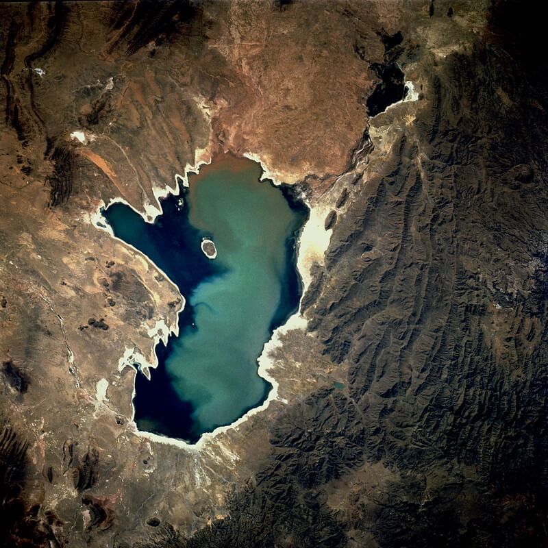
NASA image of Lake Poopó, Bolivia, September 1991
Lake Uru Uru
Lake Uru Uru, located in Bolivia's Oruro Department, is fed by the Desaguadero and Jach'a Jawira rivers. The lake is situated at an elevation of 3,686 m (12,093 ft) asl and has a surface area of 214 sq km (82.6 sq mi). The city of Oruro, a mining center, is located near its shore.
During a prolonged drought in 2016, the lake lost almost all of its water.
Desaguadero River
The Desaguadero River begins at the southern end of Lake Titicaca, near the border with Peru. It drains approximately 5% of the lake's excess water.
The river travels over 300 km (200 mi) in a southeasterly direction until it ultimately drains into what are now the mostly parched salt flats of Uru Uru and Poopó lakes, just south of the Bolivian city of Oruro.
The Desaguadero River is only navigable by small craft and supports indigenous communities such as the Uru Muratu community.
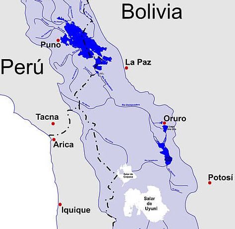
Map depicting Lake Titicaca, Rio Desaguadero, Lago Poopó, Lago Uru Uru and the Salar de Uyuni basin